31:
366:, England. Local governance is provided through the 'grouped' Parish Council for Aston Botterill, Burwarton and Cleobury North. The Parish falls within the Brown Clee Division of the Shropshire Unitary Council. There is no village meeting place, but the combined parishes share the facilities of the Village Hall at Cleobury North. The Burwarton Parish embraces most of the 'home estate' around Burwarton House. This rises westward from the main Bridgnorth-Ludlow road, passing north–south through the village, up to the ridge summit of Brown Clee Hill.
51:
372:: nearby are Burwarton Cottage owned by the Scout organisation and Wenlock hills. The Shropshire Way passes along the western border of the parish close to the Brown Clee summit. Orienteering and Mountain Bike events take place periodically. The famous annual Burwarton Show has its offices here. The show is actually held in the adjacent village of Cleobury North. Public Footpaths criss-cross the parish and the Boyne Estate. Burwarton Parish Church is now a private residence.
457:
438:
58:
238:
413:
278:
262:
498:
382:, whose family gives their name to the village pub, the Boyne Arms. Hiking route information is also available from links on the website of the Boyne Arms at
97:
30:
224:
517:
527:
286:
250:
50:
255:
322:
491:
304:
522:
267:
212:
176:
140:
393:
90:
484:
314:
359:
309:
190:
166:
442:
122:
243:
158:
217:
468:
379:
511:
106:
456:
464:
363:
205:
148:
130:
71:
337:
324:
200:
437:
182:
383:
472:
277:
261:
249:
237:
223:
211:
199:
189:
175:
157:
139:
121:
105:
89:
81:
23:
492:
8:
499:
485:
20:
405:
276:
232:
198:
174:
88:
27:
260:
248:
236:
222:
210:
188:
156:
138:
120:
7:
453:
451:
14:
57:
455:
436:
56:
49:
29:
414:"Civil Parish population 2011"
1:
394:Listed buildings in Burwarton
518:Civil parishes in Shropshire
471:. You can help Knowledge by
370:Notable Landmarks and Events
91:OS grid reference
18:Human settlement in England
544:
528:Shropshire geography stubs
450:
295:
273:
233:
44:
28:
358:is a small village and
39:public house, Burwarton
523:Villages in Shropshire
467:location article is a
213:Postcode district
141:Ceremonial county
123:Unitary authority
445:at Wikimedia Commons
191:Sovereign state
334: /
279:UK Parliament
225:Dialling code
480:
479:
441:Media related to
353:
352:
535:
501:
494:
487:
459:
452:
440:
425:
424:
422:
420:
410:
349:
348:
346:
345:
344:
339:
338:52.462°N 2.562°W
335:
332:
331:
330:
327:
301:
185:
101:
100:
70:Location within
60:
59:
53:
33:
21:
543:
542:
538:
537:
536:
534:
533:
532:
508:
507:
506:
505:
448:
434:
429:
428:
418:
416:
412:
411:
407:
402:
390:
378:is the seat of
376:Burwarton House
342:
340:
336:
333:
328:
325:
323:
321:
320:
319:
299:
291:
181:
171:
153:
135:
117:
96:
95:
85:233 (2011)
77:
76:
75:
74:
68:
67:
66:
65:
61:
40:
19:
12:
11:
5:
541:
539:
531:
530:
525:
520:
510:
509:
504:
503:
496:
489:
481:
478:
477:
460:
433:
432:External links
430:
427:
426:
404:
403:
401:
398:
397:
396:
389:
386:
380:Viscount Boyne
351:
350:
343:52.462; -2.562
318:
317:
312:
307:
302:
300:List of places
296:
293:
292:
290:
289:
283:
281:
275:
274:
271:
270:
265:
259:
258:
253:
247:
246:
241:
235:
234:
231:
230:
227:
221:
220:
215:
209:
208:
203:
197:
196:
195:United Kingdom
193:
187:
186:
179:
173:
172:
170:
169:
163:
161:
155:
154:
152:
151:
145:
143:
137:
136:
134:
133:
127:
125:
119:
118:
116:
115:
111:
109:
103:
102:
93:
87:
86:
83:
79:
78:
69:
63:
62:
55:
54:
48:
47:
46:
45:
42:
41:
34:
26:
25:
17:
13:
10:
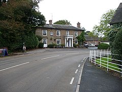
9:
6:
4:
3:
2:
540:
529:
526:
524:
521:
519:
516:
515:
513:
502:
497:
495:
490:
488:
483:
482:
476:
474:
470:
466:
461:
458:
454:
449:
446:
444:
439:
431:
415:
409:
406:
399:
395:
392:
391:
387:
385:
384:
381:
377:
373:
371:
367:
365:
361:
357:
347:
316:
313:
311:
308:
306:
303:
298:
297:
294:
288:
285:
284:
282:
280:
272:
269:
268:West Midlands
266:
264:
257:
254:
252:
245:
242:
240:
228:
226:
219:
216:
214:
207:
204:
202:
194:
192:
184:
180:
178:
168:
167:West Midlands
165:
164:
162:
160:
150:
147:
146:
144:
142:
132:
129:
128:
126:
124:
113:
112:
110:
108:
104:
99:
94:
92:
84:
80:
73:
52:
43:
38:
32:
22:
16:
473:expanding it
462:
447:
435:
417:. Retrieved
408:
375:
374:
369:
368:
360:civil parish
355:
354:
107:Civil parish
36:
15:
419:23 November
341: /
244:West Mercia
512:Categories
465:Shropshire
400:References
364:Shropshire
326:52°27′43″N
315:Shropshire
256:Shropshire
206:Bridgnorth
149:Shropshire
131:Shropshire
82:Population
72:Shropshire
37:Boyne Arms
443:Burwarton
356:Burwarton
329:2°33′43″W
263:Ambulance
201:Post town
114:Burwarton
64:Burwarton
24:Burwarton
388:See also
98:SO618850
310:England
183:England
177:Country
287:Ludlow
239:Police
159:Region
463:This
229:01746
469:stub
421:2015
251:Fire
218:WV16
35:The
362:in
514::
305:UK
500:e
493:t
486:v
475:.
423:.
Text is available under the Creative Commons Attribution-ShareAlike License. Additional terms may apply.
↑