1068:
534:
198:
38:
1023:, which have lower traffic densities than the main trunk roads, or A roads. This classification has nothing to do with the width or quality of the physical road, and B roads can range from dual carriageways to single track roads with passing places. B roads follow the same numbering scheme as A roads, but almost always have 3- and 4-digit designations. Many 3-digit B roads outside the
140:. A classification system was created in 1922, under which important routes connecting large population centres, or for through traffic, were designated as Class I, and roads of lesser importance were designated as Class II. The definitive list of those roads was published on 1 April 1923, following consultations with
391:. In Central London, the A40 (Holborn Viaduct, Holborn, High Holborn and Oxford Street) provides a border between the 4 and 5 zones east of Marble Arch. The original A5 (now renumbered A5183) also provides such a border, and north of St Albans the original A6 (now renumbered A1081) provides an Eastern border.
732:(The A6 originally started in Barnet on the old A1. When the A1 was moved onto the Barnet Bypass in the 1950s, the A6 was cut back to the A1/A1(M) junction (later A1/M25 junction). Further renumbering in the St Albans area means that it now starts in Luton town centre. The old route is numbered as A1081).
156:
With the introduction of motorways in the late 1950s, a new classification of "M" was introduced. In many cases the motorways duplicated existing stretches of A road, which therefore lost much of their significance and were in some cases renumbered. There was no consistent approach to the renumbering
147:
Shortly after this, the numbers started to appear in road atlases and on signs on the roads themselves, making them a tool for motorists in addition to their use for determining funding. The numbers of the roads changed quite frequently during the early years of the system, because it was a period of
57:
and identify all roads. Each road is given a single letter (representing a category) and a subsequent number (between one and four digits). Though this scheme was introduced merely to simplify funding allocations, it soon became used on maps and as a method of navigation. There are two sub-schemes in
873:
The system continues to three and four digit numbers which further split and criss-cross the radials. Lower numbers originate closer to London than higher numbered ones. As roads have been improved since the scheme commenced, some roads with 3 or 4 digit numbers have increased in significance, for
544:
first came to
Britain over three decades after the advent of the A-road numbering event, and as a result required a new numbering system. They were given an M prefix, and in England and Wales a numbering system of their own not coterminous with that of the A-road network, though based on the same
1148:
prefixes but, while these are numbered, in general this is done for use by the local authorities who are responsible for maintaining them and the non-unique numbering is in a local series which usually does not appear on road signs; use of local numbers on signs in
England is "not advised".
979:
Some sections of A roads have been improved to the same standard as motorways, but do not completely replace the existing road; they form a higher standard part of the route for those which are not excluded. These sections retain the same number but are suffixed with (M), for example the
509:, causing some of the roads in Zone 1 to lie in Zone 6. The designated A1 later moved to the western bypass around the city, and roads between the two found themselves back in Zone 1. For the most part the roads affected retained their original numbers throughout.
69:, no E-routes are signposted in the United Kingdom. Due to changes in local road designation, in some cases roads are numbered out of zone. There are also instances where two unrelated roads have been given exactly the same number; for example, the
120:- money raised by taxation to pay for new road construction and for repair of damage done to existing roads by the growing number of motorists. As the Board needed to work out which roads should be funded, upgraded or replaced, its secretary,
152:
gave the
Ministry direct control of major routes and a new classification system was created to identify these routes. Originally, those numbers beginning in T were to be made public, but that was eventually deemed unnecessary.
573:, the UK's first motorway section, should have been numbered A6(M) under the scheme decided upon, but it was decided to keep the number M6 as had already been applied. The first full-length motorway in the UK was the
841:
be slightly less important, but may still be classified as trunk routes, although many of these routes have lost a lot of their significance due to motorway bypasses, or the upgrading of other A-roads (such as the
1035:
B roads in the county of Devon have further sub-classifications according to their accessibility. This is due to the rural nature of Devon's topology making some roads unsuitable for certain types of vehicle.
616:(Scottish Government after 1999), the decision was taken to adopt a scheme whereby motorways took the numbers of the all-purpose routes they replaced. As a result, there is no M7 (as no motorway follows the
846:). These routes are not all centred on London, but as far as possible follow the general principle that their number locates them radially clockwise from the associated single digit route. For example, the
1766:
829:
While these routes remain the basis for the numbering of the A road network, they are no longer necessarily major roads, having been bypassed by motorways or other changes to the road network.
471:
1726:
1721:
1716:
1711:
1706:
1701:
1696:
1691:
1686:
1665:
1660:
1655:
1650:
1645:
1640:
1635:
1630:
1625:
1309:
1116:
1111:
1106:
1101:
1096:
1091:
1086:
1081:
1076:
946:
941:
936:
931:
926:
921:
916:
911:
906:
988:. There have been occasions where this designation has been used to indicate motorway bypasses of an existing road, but the original retains the A road designation, for example
897:
is a proposed classification of major local-authority controlled A roads that the government committed to implementing in 2017, with the aim of better targeting road funding.
128:, one of the Board's senior engineers, to devise a classification system and then assign numbers to the highways for identification purposes. The work was interrupted by the
1467:
1166:
136:
was formed in 1919 and given authority to classify highways and to allocate funding for road maintenance, authority for which was granted by section 17 (2) of the
1544:
612:, and applied only in England and Wales. It was decided to reserve the numbers 7, 8 & 9 for Scotland. In Scotland, where roads were the responsibility of the
1756:
1751:
870:(London to Dover), and so on. These roads have been numbered either outwards from or clockwise around their respective hubs, depending on their alignment.
581:
516:
1213:, no road that forms part of this network is signposted as such and only the road's national designation is shown. The same is true in Northern Ireland.
1424:
501:
starts in Zone 3, and is therefore numbered with an A3x number, even though it passes through Zones 4 and 5 to end in Zone 6. Additionally, the A1 in
185:). Occasionally, the new motorway would take the name of the old A road rather than having its own number. The most notable example of that is the
1761:
1573:
649:
In
England and Wales, the six single-digit numbers reflect the traditionally most important radial routes coming out of London. Starting with the
528:
59:
1496:
1067:
705:, (Also known as the Great West Road or the Bath Road), although this route is not used as a long-distance road since the completion of the
1787:
1610:
967:, which implies that central government rather than local government has responsibility for them. A more recent classification is that of
485:
The first digit in the number of any road should be the number of the furthest-anticlockwise zone entered by that road. For example, the
1731:
1670:
1537:
1390:
1267:
1242:
1027:
area are former A roads which have been downgraded owing to new road construction; others may link smaller settlements to A roads.
218:. In both cases the main single-digit roads normally define the zone boundaries. The exception is between Zones 1 and 2, where the
169:
in
Warwickshire became the A3400 after the M40 was built), and the remainder were downgraded to B or unclassified roads (e.g. the
1588:
210:
In
England and Wales the road numbering system for all-purpose (i.e. non-motorway) roads is based on a radial pattern centred on
1316:
1190:
1162:
137:
512:
Elsewhere when single-digit roads were bypassed, roads were often re-numbered in keeping with the original zone boundaries.
1598:
1583:
1578:
1530:
580:
Shorter motorways typically take their numbers from a parent motorway in contravention of the zone system, explaining the
30:
1210:
105:
66:
971:, the category of recommended routes for long-distance traffic. Primary routes include both trunk and non-trunk roads.
533:
1553:
1039:
The classification is denoted by the colour of the sign border and direction arrow, and can be summarised as follows:
554:
550:
1234:
1341:
93:
426:. Between St Albans and Luton, the original A6 (now renumbered A1081) provides the Western border of the 6-zone.
751:
609:
144:. Government funding towards the repairs of these roads were set at 60% for the former and 50% for the latter.
133:
97:
197:
981:
863:
779:
761:
740:
722:
712:
698:
678:
657:
650:
617:
457:
806:
773:
755:
325:
886:. New routes have also been allocated 3 or 4 digit numbers, for example the Edinburgh City Bypass is the
801:
on 16 May 1935, and later cut back at the southern end because of the construction of the main runway at
430:
148:
rapid expansion of the network and some numbered routes did not follow the most usual routes taken. The
121:
70:
958:
814:
149:
1593:
1406:
1170:
502:
117:
74:
736:
Similarly, in
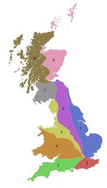
Scotland, important roads radiating from Edinburgh have single-digit numbers, thus:
1284:
894:
867:
859:
855:
851:
847:
399:
315:
166:
1363:
116:
Work on classification began in 1913. The Road Board had been established in 1909 to administer
1492:
1386:
1263:
1238:
1201:
prefixes for Cycle
Superhighways, marked using magenta signs, but these are being phased out.
802:
794:
747:
729:
141:
37:
1005:
993:
985:
419:
372:
267:
50:
653:
which heads due north, numbers were allocated sequentially in a clockwise direction, thus:
1001:
843:
818:
629:
613:
453:
407:
341:
337:
178:
129:
101:
429:
Zone 7: North of the Solway Firth/Eden
Estuary, west of the A7, south of the A8 covering
17:
1149:
Exceptions to this are known in the forms of numbers on signs and past use of prefixes
1020:
798:
672:
570:
411:
376:
321:
285:
263:
239:
231:
54:
1781:
1158:
968:
601:
597:
461:
311:
259:
255:
125:
46:
810:
633:
605:
589:
585:
438:
364:
360:
281:
271:
247:
227:
219:
162:
1517:
1046:- roads suitable for cars, minibuses and light goods vehicles - but NOT caravans
964:
706:
668:
667:, (Also known as the Great North Road), but most of the road is bypassed by the
574:
566:
562:
558:
546:
506:
446:
368:
345:
329:
243:
174:
1522:
1449:
1173:, including the creation of a new vehicular access onto a highway. The letter
879:
692:
593:
490:
395:
388:
349:
307:
1512:
569:
numbers were reserved for the other two planned long distance motorways. The
505:
has moved twice. Originally along the Great North Road, it then moved to the
157:– some A roads retained their existing number as non-primary roads (e.g. the
887:
883:
875:
790:
786:
743:
702:
664:
541:
498:
403:
353:
303:
275:
251:
215:
850:(London to King's Lynn) is the first main route clockwise from the A1, the
765:
716:
625:
621:
486:
479:
434:
423:
380:
170:
158:
85:
837:
These radials are supplemented by two-digit codes which are routes that
989:
805:
on top of it. As such, the route from
Edinburgh is now replaced by the
782:
769:
688:
442:
415:
384:
333:
302:
Zone 3: North/West of the A3, south of the A4 covering part of Surrey,
81:
685:, (The southern part of Watling Street, also known as the Dover Road).
1468:"DfT - Guidance on Road Classification and the Primary Route Network"
1024:
997:
822:
660:
494:
475:
293:
289:
211:
182:
1132:
Roads and lanes with yet lower traffic densities are designated as
452:
Zone 8: North of the A8, west of the A9 covering northern Glasgow,
1425:"Proposals for the Creation of a Major Road Network: Consultation"
1066:
772:, now has a 25-mile (40 km) gap, where it is replaced by the
725:
682:
532:
235:
196:
186:
89:
36:
1364:"List of Class I and Class II Roads and Numbers (transcription)"
1209:
Despite numerous large roads in Great Britain being part of the
1178:
467:
297:
1526:
1052:- roads that are only suitable for cars and other light traffic
394:
Zone 6: East of the A6 and A7, west of the A1 covering eastern
1407:"Sandbox: 1920s Renumbering - Roader's Digest: The SABRE Wiki"
1197:
prefix and marked using pale green signs. There are also some
549:
the zones were defined for Zones 1 to 4 based on the proposed
608:. This numbering system was devised in 1958–59 by the then
359:
Zone 5: North/East of the A5, west of the A6, south of the
320:
Zone 4: North of the A4, south/west of the A5 covering the
65:
While some of Great Britain's major roads form part of the
1231:
Just Taxes: The Politics of Taxation in Britain, 1914–1979
201:
This sign at Crouch Hill shows two road numbers in Zone 2.
165:), others were given "less significant" numbers (e.g. the
1315:. Department for Transport. 5 August 2005. Archived from
92:; a separate system using similar conventions is used in
222:
defines the boundary so that all of Kent is in Zone 2.
41:
The numbering zones for A & B roads in Great Britain
1368:
HMSO and National Archives files MT39/241 and MT39/246
1513:
Pathetic Motorways – How the motorways were numbered
1744:
1679:
1618:
1609:
1560:
1262:. Newcastle: Red Kite Prayer/Front Page Creations.
1177:is used for many important unclassified roads in
862:(London to Shoeburyness); the next radial is the
466:Zone 9: North of the A8, east of the A9 covering
545:principle of zones. Running clockwise from the
96:, as well as outside the United Kingdom in the
1538:
1487:Bancroft, Peter; Andrew Emmerson (May 2007).
8:
214:. In Scotland the same scheme is centred on
1071:C road sign in Ribblesdale, North Yorkshire
821:). On 1 April 1997, the A9 was diverted to
1615:
1545:
1531:
1523:
1058:- roads recommended for local traffic only
854:(London to Norwich) is the next, then the
537:Motorway number zones of England and Wales
1342:"History of roads and National Highways"
671:and many sections have been upgraded to
610:Ministry of Transport and Civil Aviation
1221:
719:, (The Northern part of Watling Street)
529:List of motorways in the United Kingdom
1489:A, B, C and M: Road Numbering Revealed
62:, and another for non-motorway roads.
1163:main roads have a regular grid system
768:, which formerly linked Edinburgh to
695:, (Also known as the Portsmouth Road)
7:
1165:. These designations are used when
758:motorways now form the primary link.
632:, the short M85 became part of the
1381:Porter, John; Bridle, Ron (2002).
1344:. National Highways. 15 April 2020
825:and Scrabster at the northern end.
284:, east of the A3 covering most of
230:, east of the A1 covering much of
25:
1491:. Capital Transport Publishing.
1285:"Road numbers: how it happened"
1385:. Thomas Telford. p. 27.
1310:"FOI Request – Road numbering"
953:Trunk roads and primary routes
858:(London to Lowestoft) and the
138:Ministry of Transport Act 1919
132:. It did not resume until the
1:
1518:roads.org.uk - Road Numbering
1260:Roads Were Not Built For Cars
624:was re-routed to replace the
31:Odonymy in the United Kingdom
1211:International E-road network
963:Some A roads are designated
582:apparently anomalous numbers
173:, which was replaced by the
106:British Overseas Territories
80:This scheme applies only to
67:international E-road network
1788:Roads in the United Kingdom
1554:Roads in the United Kingdom
1804:
1752:Anomalously numbered roads
1430:. Department for Transport
1235:Cambridge University Press
1229:Daunton, Martin J (2002).
956:
789:. Originally Edinburgh to
604:motorways as those of the
526:
77:are both designated A594.
28:
793:, the A9 was extended to
1599:Gaelic-speaking Scotland
1567:Road numbering schemes:
1383:The Motorway Achievement
18:B roads in Great Britain
1411:www.sabre-roads.org.uk
1258:Reid, Carlton (2014).
1072:
538:
202:
161:running alongside the
42:
1171:planning applications
1136:roads commonly using
1123:Other classifications
1070:
817:as an alternative to
536:
431:Dumfries and Galloway
280:Zone 2: South of the
226:Zone 1: North of the
200:
134:Ministry of Transport
122:William Rees Jeffreys
40:
1767:Primary destinations
959:Trunk roads in Wales
815:Queensferry Crossing
645:Single-digit A roads
517:anomalously numbered
150:Trunk Roads Act 1936
503:Newcastle upon Tyne
472:North East Scotland
118:Vehicle Excise Duty
71:Leicester Ring Road
1169:deal with certain
1128:Unclassified roads
1073:
895:Major Road Network
866:, followed by the
539:
400:North East England
316:South West England
203:
43:
1775:
1774:
1740:
1739:
1574:Motoring taxation
1498:978-1-85414-307-5
1167:planning officers
1021:distributor roads
975:Motorway sections
803:Edinburgh Airport
142:local authorities
75:a road in Cumbria
16:(Redirected from
1795:
1732:Northern Ireland
1671:Northern Ireland
1616:
1547:
1540:
1533:
1524:
1502:
1475:
1474:
1472:
1464:
1458:
1457:
1454:www.roads.org.uk
1446:
1440:
1439:
1437:
1435:
1429:
1421:
1415:
1414:
1403:
1397:
1396:
1378:
1372:
1371:
1360:
1354:
1353:
1351:
1349:
1338:
1332:
1331:
1329:
1327:
1321:
1314:
1306:
1300:
1299:
1297:
1295:
1281:
1275:
1273:
1255:
1249:
1248:
1226:
1063:Lists of B roads
1031:B roads in Devon
901:Lists of A roads
620:), and when the
515:A few roads are
439:Central Scotland
420:Scottish Borders
268:Scottish Borders
94:Northern Ireland
51:numbering scheme
21:
1803:
1802:
1798:
1797:
1796:
1794:
1793:
1792:
1778:
1777:
1776:
1771:
1736:
1675:
1605:
1556:
1551:
1509:
1499:
1486:
1483:
1481:Further reading
1478:
1470:
1466:
1465:
1461:
1450:"Devon help us"
1448:
1447:
1443:
1433:
1431:
1427:
1423:
1422:
1418:
1405:
1404:
1400:
1393:
1380:
1379:
1375:
1362:
1361:
1357:
1347:
1345:
1340:
1339:
1335:
1325:
1323:
1319:
1312:
1308:
1307:
1303:
1293:
1291:
1283:
1282:
1278:
1270:
1257:
1256:
1252:
1245:
1228:
1227:
1223:
1219:
1207:
1187:
1130:
1125:
1065:
1033:
1014:
977:
961:
955:
903:
835:
750:, although the
647:
642:
614:Scottish Office
596:of the M4, and
531:
525:
454:Argyll and Bute
408:Nottinghamshire
342:Buckinghamshire
338:Gloucestershire
266:, parts of the
208:
195:
130:First World War
114:
102:Roads in Jersey
33:
23:
22:
15:
12:
11:
5:
1801:
1799:
1791:
1790:
1780:
1779:
1773:
1772:
1770:
1769:
1764:
1759:
1754:
1748:
1746:
1742:
1741:
1738:
1737:
1735:
1734:
1729:
1724:
1719:
1714:
1709:
1704:
1699:
1694:
1689:
1683:
1681:
1677:
1676:
1674:
1673:
1668:
1663:
1658:
1653:
1648:
1643:
1638:
1633:
1628:
1622:
1620:
1613:
1607:
1606:
1604:
1603:
1602:
1601:
1596:
1586:
1581:
1576:
1571:
1564:
1562:
1558:
1557:
1552:
1550:
1549:
1542:
1535:
1527:
1521:
1520:
1515:
1508:
1507:External links
1505:
1504:
1503:
1497:
1482:
1479:
1477:
1476:
1459:
1441:
1416:
1398:
1391:
1373:
1355:
1333:
1322:on 12 May 2009
1301:
1276:
1268:
1250:
1243:
1220:
1218:
1215:
1206:
1203:
1193:are using the
1186:
1183:
1129:
1126:
1124:
1121:
1120:
1119:
1117:Zone 9 B roads
1114:
1112:Zone 8 B roads
1109:
1107:Zone 7 B roads
1104:
1102:Zone 6 B roads
1099:
1097:Zone 5 B roads
1094:
1092:Zone 4 B roads
1089:
1087:Zone 3 B roads
1084:
1082:Zone 2 B roads
1079:
1077:Zone 1 B roads
1064:
1061:
1060:
1059:
1053:
1047:
1032:
1029:
1013:
1010:
976:
973:
969:primary routes
954:
951:
950:
949:
947:Zone 9 A roads
944:
942:Zone 8 A roads
939:
937:Zone 7 A roads
934:
932:Zone 6 A roads
929:
927:Zone 5 A roads
924:
922:Zone 4 A roads
919:
917:Zone 3 A roads
914:
912:Zone 2 A roads
909:
907:Zone 1 A roads
902:
899:
834:
831:
827:
826:
795:John o' Groats
777:
759:
734:
733:
720:
710:
696:
686:
676:
646:
643:
641:
638:
571:Preston Bypass
527:Main article:
524:
521:
483:
482:
464:
450:
427:
412:Leicestershire
392:
377:Leicestershire
357:
318:
300:
278:
264:Northumberland
240:Cambridgeshire
207:
204:
194:
191:
113:
110:
24:
14:
13:
10:
9:
6:
4:
3:
2:
1800:
1789:
1786:
1785:
1783:
1768:
1765:
1763:
1760:
1758:
1755:
1753:
1750:
1749:
1747:
1743:
1733:
1730:
1728:
1725:
1723:
1720:
1718:
1715:
1713:
1710:
1708:
1705:
1703:
1700:
1698:
1695:
1693:
1690:
1688:
1685:
1684:
1682:
1678:
1672:
1669:
1667:
1664:
1662:
1659:
1657:
1654:
1652:
1649:
1647:
1644:
1642:
1639:
1637:
1634:
1632:
1629:
1627:
1624:
1623:
1621:
1617:
1614:
1612:
1608:
1600:
1597:
1595:
1592:
1591:
1590:
1587:
1585:
1582:
1580:
1577:
1575:
1572:
1570:
1569:Great Britain
1566:
1565:
1563:
1559:
1555:
1548:
1543:
1541:
1536:
1534:
1529:
1528:
1525:
1519:
1516:
1514:
1511:
1510:
1506:
1500:
1494:
1490:
1485:
1484:
1480:
1469:
1463:
1460:
1455:
1451:
1445:
1442:
1426:
1420:
1417:
1412:
1408:
1402:
1399:
1394:
1392:0-7277-3196-3
1388:
1384:
1377:
1374:
1369:
1365:
1359:
1356:
1343:
1337:
1334:
1318:
1311:
1305:
1302:
1290:
1286:
1280:
1277:
1271:
1269:9780993005701
1265:
1261:
1254:
1251:
1246:
1244:0-521-81400-6
1240:
1236:
1232:
1225:
1222:
1216:
1214:
1212:
1204:
1202:
1200:
1196:
1192:
1184:
1182:
1180:
1176:
1172:
1168:
1164:
1160:
1159:Milton Keynes
1156:
1152:
1147:
1143:
1139:
1135:
1127:
1122:
1118:
1115:
1113:
1110:
1108:
1105:
1103:
1100:
1098:
1095:
1093:
1090:
1088:
1085:
1083:
1080:
1078:
1075:
1074:
1069:
1062:
1057:
1054:
1051:
1048:
1045:
1042:
1041:
1040:
1037:
1030:
1028:
1026:
1022:
1019:are numbered
1018:
1011:
1009:
1007:
1003:
999:
995:
991:
987:
983:
974:
972:
970:
966:
960:
952:
948:
945:
943:
940:
938:
935:
933:
930:
928:
925:
923:
920:
918:
915:
913:
910:
908:
905:
904:
900:
898:
896:
891:
889:
885:
881:
877:
871:
869:
865:
861:
857:
853:
849:
845:
840:
833:Other A roads
832:
830:
824:
820:
816:
812:
808:
804:
800:
796:
792:
788:
784:
781:
778:
775:
771:
767:
764:Edinburgh to
763:
760:
757:
753:
749:
745:
742:
739:
738:
737:
731:
727:
724:
721:
718:
714:
711:
708:
704:
700:
697:
694:
690:
687:
684:
680:
677:
674:
670:
666:
662:
659:
656:
655:
654:
652:
644:
639:
637:
635:
631:
627:
623:
619:
615:
611:
607:
603:
599:
595:
592:motorways as
591:
587:
583:
578:
576:
572:
568:
564:
560:
556:
552:
548:
543:
535:
530:
522:
520:
518:
513:
510:
508:
504:
500:
496:
493:running from
492:
488:
481:
477:
473:
469:
465:
463:
462:Western Isles
459:
455:
451:
448:
445:south of the
444:
440:
436:
432:
428:
425:
421:
417:
413:
409:
405:
401:
397:
393:
390:
386:
382:
378:
374:
370:
366:
362:
358:
355:
351:
347:
343:
339:
335:
331:
327:
326:West Midlands
323:
319:
317:
313:
312:Isle of Wight
309:
305:
301:
299:
295:
291:
287:
283:
279:
277:
274:and on up to
273:
269:
265:
261:
260:Tyne and Wear
257:
256:County Durham
253:
249:
245:
241:
237:
233:
229:
225:
224:
223:
221:
217:
213:
205:
199:
193:Zoning system
192:
190:
188:
184:
180:
176:
172:
168:
164:
160:
154:
151:
145:
143:
139:
135:
131:
127:
126:Henry Maybury
123:
119:
111:
109:
107:
103:
99:
95:
91:
87:
83:
78:
76:
72:
68:
63:
61:
58:use: one for
56:
52:
49:, there is a
48:
47:Great Britain
39:
35:
32:
27:
19:
1680:B-road lists
1619:A-road lists
1568:
1488:
1462:
1453:
1444:
1432:. Retrieved
1419:
1410:
1401:
1382:
1376:
1367:
1358:
1346:. Retrieved
1336:
1324:. Retrieved
1317:the original
1304:
1292:. Retrieved
1289:Roads.org.uk
1288:
1279:
1259:
1253:
1230:
1224:
1208:
1198:
1194:
1188:
1174:
1157:on signs in
1154:
1150:
1145:
1141:
1137:
1134:unclassified
1133:
1131:
1055:
1049:
1043:
1038:
1034:
1016:
1015:
978:
962:
892:
874:example the
872:
838:
836:
828:
735:
648:
579:
559:M4 motorways
540:
514:
511:
484:
441:, including
387:and western
365:Eden Estuary
361:Solway Firth
286:South London
272:East Lothian
248:Lincolnshire
232:North London
220:River Thames
209:
206:Non-motorway
155:
146:
124:, appointed
115:
79:
64:
44:
34:
26:
1745:Other lists
1348:23 December
1326:27 December
1233:. England:
1189:In London,
965:trunk roads
813:across the
575:M1 motorway
507:Tyne Tunnel
369:North Wales
330:Oxfordshire
306:(excluding
250:, parts of
244:East Anglia
98:Isle of Man
1589:Road signs
1434:5 February
1217:References
957:See also:
809:(with the
715:London to
701:London to
693:Portsmouth
691:London to
681:London to
491:trunk road
418:, and the
410:, eastern
396:Lancashire
389:Lancashire
375:, western
308:Portsmouth
288:, part of
29:See also:
1762:Motorways
1757:Junctions
1191:Cycleways
1185:Cycleways
791:Inverness
787:Scrabster
744:Edinburgh
703:Avonmouth
665:Edinburgh
628:south of
542:Motorways
523:Motorways
499:Mansfield
404:Yorkshire
367:covering
354:Mid Wales
304:Hampshire
276:Edinburgh
252:Yorkshire
216:Edinburgh
60:motorways
1782:Category
1561:Articles
1294:18 March
766:Greenock
748:Carlisle
730:Carlisle
717:Holyhead
487:A38 road
480:Shetland
460:and the
458:Highland
435:Ayrshire
424:Lothians
381:Cheshire
373:Midlands
371:, North
179:Tiverton
177:between
86:Scotland
55:classify
53:used to
1584:Odonymy
1579:Driving
1205:E-roads
1017:B roads
1012:B roads
1006:A627(M)
994:A329(M)
986:A404(M)
844:A38 (M)
783:Falkirk
770:Glasgow
640:A roads
584:of the
443:Glasgow
416:Rutland
385:Cumbria
334:Bristol
310:), the
112:History
82:England
1495:
1389:
1266:
1241:
1161:where
1025:London
1002:A48(M)
998:A38(M)
823:Thurso
661:London
561:. The
495:Bodmin
476:Orkney
294:Sussex
290:Surrey
282:Thames
228:Thames
212:London
183:Exeter
1611:Zones
1594:Wales
1471:(PDF)
1428:(PDF)
1320:(PDF)
1313:(PDF)
1274:p.30.
1056:White
1050:Brown
990:A3(M)
982:A1(M)
880:A1079
819:Perth
726:Luton
683:Dover
673:A1(M)
630:Perth
594:spurs
447:Clyde
346:south
322:south
236:Essex
187:A1(M)
90:Wales
1493:ISBN
1436:2018
1387:ISBN
1350:2022
1328:2007
1296:2022
1264:ISBN
1239:ISBN
1179:Fife
1153:and
1144:and
1044:Blue
1004:and
984:and
893:The
888:A720
884:A414
882:and
876:A127
799:Wick
797:via
754:and
602:M275
600:and
598:M271
588:and
565:and
557:and
489:, a
478:and
468:Fife
437:and
422:and
414:and
352:and
350:west
344:and
324:and
314:and
298:Kent
296:and
181:and
104:and
88:and
73:and
868:A20
860:A13
856:A12
852:A11
848:A10
839:may
811:M90
785:to
752:M74
746:to
728:to
663:to
634:M90
626:A85
622:A90
606:M27
590:M49
586:M48
497:to
171:A38
167:A34
163:M40
159:A40
45:In
1784::
1452:.
1409:.
1366:.
1287:.
1237:.
1199:CS
1181:.
1140:,
1008:.
1000:,
996:,
992:,
890:.
878:,
864:A2
807:M9
780:A9
774:M8
762:A8
756:M8
741:A7
723:A6
713:A5
707:M4
699:A4
689:A3
679:A2
669:M1
658:A1
651:A1
636:.
618:A7
577:.
567:M6
563:M5
555:M3
553:,
551:M2
547:M1
519:.
474:,
470:,
456:,
433:,
406:,
402:,
398:,
383:,
379:,
348:,
340:,
336:,
332:,
328:,
292:,
270:,
262:,
258:,
254:,
246:,
242:,
238:,
234:,
189:.
175:M5
108:.
100:,
84:,
1727:9
1722:8
1717:7
1712:6
1707:5
1702:4
1697:3
1692:2
1687:1
1666:9
1661:8
1656:7
1651:6
1646:5
1641:4
1636:3
1631:2
1626:1
1546:e
1539:t
1532:v
1501:.
1473:.
1456:.
1438:.
1413:.
1395:.
1370:.
1352:.
1330:.
1298:.
1272:.
1247:.
1195:C
1175:Q
1155:V
1151:H
1146:U
1142:D
1138:C
776:.
709:.
675:.
449:.
363:/
356:.
20:)
Text is available under the Creative Commons Attribution-ShareAlike License. Additional terms may apply.