29:
203:
219:, Gordon Biggar, Peter Clarke, Peter Gilbert, Brian Powling, (UK) and Damian Aurelio Vargas (Peru) June 11, 2000. AAJ 1997 page 243 shows a previous ascent on 20/11/1996 when German del Rio and Jorge Llanos approached the peak on motorbikes. However, in an interview with John Biggar, he proved they did not reach the summit.
191:, with an elevation of 6,070 metres (19,915 ft) metres. The peak is also sometimes known as Veladero Northeast. The peak has one of the largest glaciers in the Puna de Atacama on its southern flank, and one of the few glaciers other than the ones on
418:
552:
557:
312:
464:
83:
547:
180:
154:
11/06/2000 – John Biggar, Gordon Biggar, Peter Clarke, Peter
Gilbert, Brian Powling, (UK) and Damian Aurelio Vargas (Peru)
76:
216:
228:
393:
252:
64:
54:
272:
517:
184:
69:
468:
308:
215:
It was one of the last 6,000m+ peaks in the Andes to be climbed. Baboso was first climbed by
493:
328:
188:
236:
130:
541:
28:
268:
192:
159:
149:
264:
276:
98:
85:
439:
123:
202:
240:
196:
176:
244:
256:
248:
44:
201:
137:
232:
350:
348:
419:"USGS EROS Archive - Digital Elevation - SRTM Coverage Maps"
302:
304:
The Andes: A Guide for
Climbers and Skiers (5th ed.)
259:. Baboso is considered a Mountain according to the
158:
148:
143:
129:
119:
114:
75:
63:
53:
43:
38:
21:
8:
307:. Andes Publishing (Scotland). p. 240.
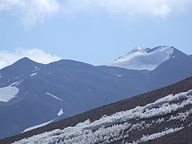
33:Baboso seen from the Cordon de los Pioneros.
394:"Capas SIG | Instituto Geográfico Nacional"
18:
553:Volcanoes of La Rioja Province, Argentina
375:Guillermo Almaraz. "Personal Interview".
465:"Copernicus Space Component Data Access"
243:6,097 metres. The height of the nearest
288:
206:The first ascent team on Baboso summit
296:
294:
292:
7:
488:
486:
388:
386:
370:
368:
366:
14:
355:"AAJ (American Alpine Journal)".
263:and its dominance is 10.02%. Its
27:
1:
357:AAJ (American Alpine Journal)
49:6,070 m (19,910 ft)
558:Six-thousanders of the Andes
574:
227:Other data from available
59:608 m (1,995 ft)
16:Mountain peak in Argentina
26:
229:digital elevation models
444:ssl.jspacesystems.or.jp
548:Mountains of Argentina
494:"Baboso / Veladero NE"
463:TanDEM-X, TerraSAR-X.
329:"Baboso / Veladero NE"
253:topographic prominence
207:
175:is a remote peak near
301:Biggar, John (2020).
273:Topographic isolation
235:yields 6,055 metres,
205:
518:"Dominance - Page 2"
440:"ASTER GDEM Project"
417:USGS, EROS Archive.
187:) in the Argentine
179:in the province of
95: /
377:Personal Interview
208:
39:Highest point
498:Andes Specialists
333:Andes Specialists
314:978-0-9536087-6-8
239:6,069 metres and
183:(municipality of
170:
169:
99:28.017°S 68.900°W
565:
532:
531:
529:
528:
514:
508:
507:
505:
504:
490:
481:
480:
478:
476:
471:on 12 April 2020
467:. Archived from
460:
454:
453:
451:
450:
436:
430:
429:
427:
425:
414:
408:
407:
405:
404:
390:
381:
380:
379:: estilo andino.
372:
361:
360:
352:
343:
342:
340:
339:
325:
319:
318:
298:
261:Dominance System
162:
133:
110:
109:
107:
106:
105:
104:-28.017; -68.900
100:
96:
93:
92:
91:
88:
31:
19:
573:
572:
568:
567:
566:
564:
563:
562:
538:
537:
536:
535:
526:
524:
522:www.8000ers.com
516:
515:
511:
502:
500:
492:
491:
484:
474:
472:
462:
461:
457:
448:
446:
438:
437:
433:
423:
421:
416:
415:
411:
402:
400:
392:
391:
384:
374:
373:
364:
354:
353:
346:
337:
335:
327:
326:
322:
315:
300:
299:
290:
285:
251:, leading to a
225:
213:
189:Puna de Atacama
166:Southwest ridge
160:
131:
103:
101:
97:
94:
89:
86:
84:
82:
81:
34:
17:
12:
11:
5:
571:
569:
561:
560:
555:
550:
540:
539:
534:
533:
509:
482:
455:
431:
409:
398:www.ign.gob.ar
382:
362:
344:
320:
313:
287:
286:
284:
281:
224:
221:
212:
209:
168:
167:
164:
156:
155:
152:
146:
145:
141:
140:
135:
127:
126:
121:
117:
116:
112:
111:
79:
73:
72:
67:
61:
60:
57:
51:
50:
47:
41:
40:
36:
35:
32:
24:
23:
15:
13:
10:
9:
6:
4:
3:
2:
570:
559:
556:
554:
551:
549:
546:
545:
543:
523:
519:
513:
510:
499:
495:
489:
487:
483:
470:
466:
459:
456:
445:
441:
435:
432:
420:
413:
410:
399:
395:
389:
387:
383:
378:
371:
369:
367:
363:
358:
351:
349:
345:
334:
330:
324:
321:
316:
310:
306:
305:
297:
295:
293:
289:
282:
280:
278:
274:
270:
266:
262:
258:
254:
250:
246:
242:
238:
234:
230:
222:
220:
218:
210:
204:
200:
198:
195:to have open
194:
190:
186:
182:
178:
174:
165:
163:
161:Easiest route
157:
153:
151:
147:
142:
139:
136:
134:
128:
125:
122:
118:
113:
108:
80:
78:
74:
71:
68:
66:
62:
58:
56:
52:
48:
46:
42:
37:
30:
25:
20:
525:. Retrieved
521:
512:
501:. Retrieved
497:
473:. Retrieved
469:the original
458:
447:. Retrieved
443:
434:
422:. Retrieved
412:
401:. Retrieved
397:
376:
359:: 328. 2002.
356:
336:. Retrieved
332:
323:
303:
269:Bonete Chico
260:
226:
214:
211:First ascent
193:Monte Pissis
172:
171:
150:First ascent
132:Parent range
265:parent peak
217:John Biggar
102: /
77:Coordinates
65:Parent peak
542:Categories
527:2020-04-12
503:2020-04-12
449:2020-04-14
403:2020-04-30
338:2020-04-12
283:References
277:kilometers
55:Prominence
247:is 5,462
223:Elevation
197:crevasses
124:Argentina
115:Geography
45:Elevation
475:12 April
424:12 April
275:is 15.2
271:and the
241:TanDEM-X
185:Vinchina
181:La Rioja
177:Veladero
144:Climbing
120:Location
255:of 608
245:key col
90:68°54′W
87:28°01′S
311:
257:meters
249:meters
173:Baboso
70:Bonete
22:Baboso
237:ASTER
138:Andes
477:2020
426:2020
309:ISBN
233:SRTM
267:is
544::
520:.
496:.
485:^
442:.
396:.
385:^
365:^
347:^
331:.
291:^
231::
530:.
506:.
479:.
452:.
428:.
406:.
341:.
317:.
279:.
199:.
Text is available under the Creative Commons Attribution-ShareAlike License. Additional terms may apply.