83:
269:
63:
152:
90:
310:
253:
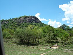
watersheds, in an important cattle ranching area with a history of gold prospecting. There is a prominent landmark nearby in the form of a granite hill (
219:
by
Europeans, which was altered to its present name in 1982 by the Zimbabwean government in order to coincide closer with the local orthography.
329:
239:
334:
82:
303:
114:
28:
223:
62:
296:
190:
202:
235:
231:
230:. The village also hosts a large army barracks, which is the Zimbabwe School of Infantry, formerly
250:
27:
This article is about the village in
Zimbabwe. For the pastoral lease in Western Australia, see
246:
280:
323:
268:
206:
166:
182:
129:
116:
68:
17:
276:
227:
198:
197:. Situated approximately 41 miles (66 km) south-east of the city of
194:
186:
156:
151:
189:
road in uMzingwane district(at the junction with the
Filabusi Road) in
53:
245:
Mbalabala is situated on high ground, which forms a ridge between the
254:
257:) known as Balloon Kop or "Baldy" - due to its bare rock.
284:
210:
162:
145:
41:
304:
8:
238:from 1976 to 1980. The site was previously
226:and is the railhead for the mining area of
311:
297:
38:
222:The village has a railway station on the
144:
109:
75:
59:
242:from February 1959 to December 1975.
161:
7:
265:
263:
25:
89:
36:Village in Matabeleland, Zimbabwe
267:
150:
88:
81:
61:
201:. The name is derived from the
29:Balla Balla, Western Australia
1:
215:. It was originally rendered
191:Matabeleland South providence
330:Populated places in Zimbabwe
283:. You can help Knowledge by
224:Beitbridge Bulawayo Railway
181:, is a village on the main
351:
262:
26:
110:
76:
60:
51:
335:Zimbabwe geography stubs
236:Rhodesian African Rifles
279:location article is a
211:
177:, originally known as
240:St. Stephen's College
102:Location of Mbalabala
126: /
292:
291:
172:
171:
16:(Redirected from
342:
313:
306:
299:
271:
264:
214:
155:
154:
141:
140:
138:
137:
136:
131:
127:
124:
123:
122:
119:
92:
91:
85:
65:
39:
21:
350:
349:
345:
344:
343:
341:
340:
339:
320:
319:
318:
317:
260:
149:
134:
132:
130:20.45°S 29.03°E
128:
125:
120:
117:
115:
113:
112:
106:
105:
104:
103:
100:
99:
98:
97:
93:
72:
71:near Mbalabala.
56:
47:
44:
37:
32:
23:
22:
15:
12:
11:
5:
348:
346:
338:
337:
332:
322:
321:
316:
315:
308:
301:
293:
290:
289:
272:
170:
169:
164:
160:
159:
147:
143:
142:
108:
107:
101:
95:
94:
87:
86:
80:
79:
78:
77:
74:
73:
66:
58:
57:
52:
49:
48:
45:
42:
35:
24:
14:
13:
10:
9:
6:
4:
3:
2:
347:
336:
333:
331:
328:
327:
325:
314:
309:
307:
302:
300:
295:
294:
288:
286:
282:
278:
273:
270:
266:
261:
258:
256:
252:
248:
243:
241:
237:
233:
232:Shaw Barracks
229:
225:
220:
218:
213:
208:
205:name for the
204:
200:
196:
192:
188:
184:
180:
176:
168:
165:
158:
153:
148:
139:
135:-20.45; 29.03
111:Coordinates:
84:
70:
64:
55:
50:
40:
34:
30:
19:
285:expanding it
274:
259:
244:
221:
216:
207:greater kudu
178:
174:
173:
167:Matabeleland
33:
217:Balla Balla
212:ibhalabhala
179:Balla Balla
133: /
46:Balla Balla
18:Balla Balla
324:Categories
251:Mbilambowe
183:Beitbridge
247:Mzingwane
175:Mbalabala
96:Mbalabala
43:Mbalabala
277:Zimbabwe
234:for the
228:Filabusi
199:Bulawayo
195:Zimbabwe
187:Bulawayo
157:Zimbabwe
67:Granite
203:Ndebele
146:Country
121:29°02′E
118:20°27′S
54:Village
163:Region
69:koppie
275:This
255:kopje
281:stub
249:and
326::
209:,
193:,
312:e
305:t
298:v
287:.
185:-
31:.
20:)
Text is available under the Creative Commons Attribution-ShareAlike License. Additional terms may apply.