292:
277:
265:
44:
406:
51:
31:
237:
in the 20th century. The village began as a seasonally inhabited trading post, until the first compound was founded by a prosperous local trader, Bakary Darboe, in the 1920s. His family was followed by relatives of
291:
187:
downstream, Bansang has better access to the more affluent coastal region of the country, and is sometimes considered the unofficial "upcountry" economic capital.
276:
377:
Bellagamba, Alice. "A Matter of Trust. Political
Identities and Interpersonal Relationships along the River Gambia." Paideuma, vol. 46, 2000, p. 38. JSTOR,
217:
Bansang became an important settlement during the colonial period as families settled there to take advantage of opportunities in the growing trade of
447:
471:
264:
476:
75:
43:
466:
322:
440:
433:
129:
117:
183:, with a population of 8,843 (2012). Although the official government center of the Division is located in
176:
122:
239:
199:
184:
163:
203:
417:
244:
365:
226:
405:
30:
460:
283:
234:
222:
134:
313:
298:
230:
180:
110:
337:
324:
90:
77:
154:
378:
413:
250:
218:
211:
159:
207:
421:
368:, Encyclopædia Britannica online. Retrieved 2012-04-30.
153:
145:
140:
128:
116:
106:
21:
190:The town is a market for peanuts, rice and fish.
198:The area was originally part of the kingdoms of
441:
8:
16:Place in Central River Division, The Gambia
448:
434:
18:
210:empire. In the 1860s the Fula kingdom of
229:were the earliest founders, followed by
358:
260:
152:
139:
105:
70:
36:
27:
144:
127:
115:
7:
402:
400:
379:http://www.jstor.org/stable/40341782
420:. You can help Knowledge (XXG) by
14:
404:
290:
275:
263:
49:
42:
29:
50:
472:Populated places in the Gambia
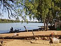
301:vehicle ferry across the river
1:
206:, constituent states of the
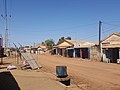
270:The main street in Bansang
493:
477:The Gambia geography stubs
399:
71:
37:
28:
214:rose as Kaabu declined.
381:. Accessed 4 June 2023.
314:The Atlas of the Gambia
467:Central River Division
416:location article is a
177:Central River Division
123:Central River Division
63:Location in the Gambia
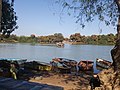
282:Upstream view of the
334: /
87: /
146: • Total
429:
428:
390:Bellagamba, 47-8.
338:13.433°N 14.650°W
299:manually-operated
240:Musa Molloh Balde
175:is a town in the
170:
169:
91:13.433°N 14.650°W
484:
450:
443:
436:
408:
401:
391:
388:
382:
375:
369:
363:
349:
348:
346:
345:
344:
339:
335:
332:
331:
330:
327:
294:
279:
267:
248:
102:
101:
99:
98:
97:
92:
88:
85:
84:
83:
80:
53:
52:
46:
33:
19:
492:
491:
487:
486:
485:
483:
482:
481:
457:
456:
455:
454:
397:
395:
394:
389:
385:
376:
372:
364:
360:
355:
343:13.433; -14.650
342:
340:
336:
333:
328:
325:
323:
321:
320:
309:
302:
295:
286:
280:
271:
268:
259:
242:
227:Mandinka people
196:
96:13.433; -14.650
95:
93:
89:
86:
81:
78:
76:
74:
73:
67:
66:
65:
64:
61:
60:
59:
58:
54:
24:
17:
12:
11:
5:
490:
488:
480:
479:
474:
469:
459:
458:
453:
452:
445:
438:
430:
427:
426:
409:
393:
392:
383:
370:
357:
356:
354:
351:
318:
317:
308:
305:
304:
303:
296:
289:
287:
281:
274:
272:
269:
262:
258:
255:
195:
192:
168:
167:
157:
151:
150:
147:
143:
142:
138:
137:
132:
126:
125:
120:
114:
113:
108:
104:
103:
69:
68:
62:
56:
55:
48:
47:
41:
40:
39:
38:
35:
34:
26:
25:
22:
15:
13:
10:
9:
6:
4:
3:
2:
489:
478:
475:
473:
470:
468:
465:
464:
462:
451:
446:
444:
439:
437:
432:
431:
425:
423:
419:
415:
410:
407:
403:
398:
387:
384:
380:
374:
371:
367:
362:
359:
352:
350:
347:
316:
315:
311:
310:
306:
300:
293:
288:
285:
278:
273:
266:
261:
256:
254:
252:
246:
241:
236:
232:
228:
224:
220:
215:
213:
209:
205:
201:
193:
191:
188:
186:
182:
178:
174:
165:
161:
158:
156:
148:
136:
133:
131:
124:
121:
119:
112:
109:
100:
72:Coordinates:
45:
32:
20:
422:expanding it
411:
396:
386:
373:
361:
319:
312:
284:River Gambia
223:Gambia river
216:
197:
189:
172:
171:
135:Fulladu West
341: /
249:, ruler of
243: [
185:Janjanbureh
94: /
461:Categories
353:References
181:the Gambia
141:Population
111:The Gambia
155:Time zone
204:Wuropana
130:District
118:Division
414:Gambian
366:Bansang
329:14°39′W
326:13°26′N
307:Sources
257:Gallery
221:on the
219:peanuts
194:History
173:Bansang
107:Country
82:14°39′W
79:13°26′N
57:Bansang
23:Bansang
251:Fuladu
212:Fuladu
200:Jimara
412:This
247:]
235:Wolof
208:Kaabu
160:UTC+0
149:8,843
418:stub
297:The
233:and
231:Fula
202:and
179:of
164:GMT
463::
253:.
245:fr
225:.
449:e
442:t
435:v
424:.
166:)
162:(
Text is available under the Creative Commons Attribution-ShareAlike License. Additional terms may apply.