402:, the seabed falls sharply from the shore before hitting the level floor of the harbour which forms a gently sloping basin of mud and gravel with a maximum depth of 9.1 metres (30 ft) near Dixon Island. Waters within a 2–3-kilometre (1.2–1.9 mi) radius of the harbour entrance vary greatly in depth with three deep channels branching out from the entrance leaving deep shoals in between at a depth of 5 metres (16 ft). The true deepest point in the harbour is where the three channels meet between Platypus Point and Nixon Point which reaches 29 metres (95 ft) due to the dredging action of the tide.
47:
517:
31:
489:
277:
503:
54:
445:
which supports an airstrip, several light structures, boat moorings and remains from the tin mines in the early 1900s. A mining department camp was formerly located at
Woureddy Bay on Melaleuca Creek and the homestead "Claytons Corner" is located at the mouth of Melaleuca Creek on Forest Lagoon which
393:
Almost all of the harbour is navigable by sailing vessels with no submerged rocks or navigational hazards except for a small area around Black Swan Island at Old Bay in the harbours north. Of the four main inflows only
Melaleuca Creek is truly navigable and maintains a depth in excess of 2–3 metres
409:
formation caused by the inundation of a large valley and its associated alluvial plains. The glacially carved landscape of the region has resulted in the shape of the estuarine system being greatly different to other ria formations around
Tasmania such as the
373:
Bathurst
Harbour is a large, rectangular, almost landlocked body of water located in the southwest corner of Tasmania. The harbour is surrounded by low-lying alluvial plains with mountain ranges running along the western and eastern shores. The
398:. With the exception of the waters around the harbour entrance, most of the harbour has a relatively flat seabed with an average depth of 7 metres (23 ft). As with almost all of the estuarine system including the
454:
Bathurst
Harbour has no vehicular access of any kind. Access is instead provided by either boat, air or walking. The only marine access to the harbour is via the Bathurst Channel from Port Davey. Two walking tracks,
602:
235:
The harbour is an expansive, almost landlocked, shallow bay of relatively uniform depth ranging from 3 to 7 metres (9.8 to 23.0 ft), which provides safe anchorage from the
562:
98:
1017:
754:
394:(6 ft 7 in – 9 ft 10 in) for more than 6.5 kilometres (4.0 mi) upstream of "Claytons Corner" which provides marine access to
294:
1012:
1043:
441:
The land around the harbour is unpopulated with little infrastructure. Most buildings and structures in the vicinity of the harbour are located at
1869:
1307:
1025:
686:
647:
1757:
1414:
674:
341:
313:
46:
1651:
1193:
1572:
747:
664:
360:
320:
1743:
1315:
984:
446:
includes a timber jetty. At present the region has no permanent population, but has in time had a number reclusive inhabitants.
327:
298:
1736:
577:
309:
1864:
1646:
1641:
1399:
1359:
1136:
823:
740:
1843:
1475:
1084:
818:
390:
all drain into the harbour either directly or into one of the many offshoot bays and inlets connected to the harbour.
1483:
1260:
1874:
1812:
1700:
1522:
1177:
221:, Australia. Bathurst Harbour is contained within the Port Davey/Bathurst Harbour Marine Nature Reserve, and the
1577:
1552:
1154:
411:
1705:
1676:
1404:
1185:
1030:
464:
375:
287:
222:
882:
828:
792:
573:
383:
379:
334:
1791:
1786:
1774:
1600:
1587:
1542:
1142:
1059:
1035:
892:
138:
1450:
1297:
1276:
1255:
813:
782:
725:
711:
610:
387:
244:
240:
226:
1750:
907:
833:
808:
787:
763:
637:
472:
442:
395:
229:
214:
198:
81:
35:
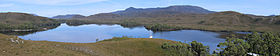
Forest Lagoon, an offshoot of
Bathurst Harbour, looking south with "Claytons Corner" in lower right
259:. Like most estuarine systems in southwest Tasmania, the water is stained a deep red-brown due to
1796:
1636:
1514:
976:
970:
838:
659:(Working paper). Sandy Bay, Tas: Steering Committee, South West Tasmania Resources Survey. 1981.
522:
475:
gives the only aerial access to the region and is in turn connected to the main walking tracks.
1656:
1595:
1557:
1537:
1394:
1369:
1292:
1219:
912:
682:
660:
643:
532:
456:
430:
1710:
1666:
1567:
1496:
1429:
1364:
1240:
1214:
927:
708:
Parks & Wildlife
Service, Department of Primary Industries, Parks, Water and Environment
516:
494:
460:
422:
399:
248:
145:
732:
703:
247:
coasts of
Tasmania. The harbour is connected by the narrow 12-kilometre (7.5 mi)-long
1838:
1780:
1615:
1532:
1488:
1245:
1172:
960:
874:
468:
236:
30:
429:
to
Tasmania, has been reported from. The main population is found in similar habitats in
1817:
1610:
1527:
1069:
917:
897:
859:
854:
256:
160:
153:
1858:
1833:
1661:
1631:
1605:
1501:
1465:
1455:
1343:
942:
937:
1715:
1562:
1547:
1074:
952:
508:
561:
Hirst, Alastair; Barrett, Neville; Meyer, Lisa; Reid, Catherine (November 2007).
1460:
1434:
1409:
1250:
1130:
1125:
1115:
1089:
1064:
932:
922:
719:
415:
276:
1424:
1224:
1167:
1105:
1079:
887:
864:
537:
484:
252:
149:
635:
Australian
Conservation Foundation (1978), Gee, Helen; Fenton, Janet (eds.),
113:
100:
1419:
1389:
1162:
502:
210:
1684:
767:
426:
218:
84:
67:
902:
301: in this section. Unsourced material may be challenged and removed.
139:
260:
414:, instead bearing close resemblance to artificial impoundments like
609:. Department of Primary Industries, Parks, Water and Environment,
421:
Bathurst Harbour is one of only two places in the world where the
607:
Sea Fishing & Aquaculture: Area Restrictions: Marine Reserves
736:
406:
405:
Bathurst Harbour, like the rest of the Bathurst Channel, is a
270:
721:
Southwest National Park: Marine Zones: Vicinity of Port Davey
563:"Port Davey – Bathurst Harbour marine benthic survey"
133:
North River, Old River, Ray River and Melaleuca Creek
1826:
1805:
1767:
1728:
1693:
1675:
1624:
1586:
1513:
1474:
1443:
1382:
1352:
1336:
1329:
1306:
1285:
1269:
1233:
1202:
1151:
1114:
1098:
1052:
1003:
983:
969:
951:
873:
847:
801:
775:
603:"Port Davey/Bathurst Harbour Marine Nature Reserve"
194:
190:
182:
174:
170:
159:
137:
129:
90:
77:
23:
1022:Port Davey/Bathurst Harbour Marine Nature Reserve
263:leached from buttongrass and adjacent heathland.
91:
16:Natural harbour on coast of South West Tasmania
1018:Melaleuca to Birchs Inlet Important Bird Area
748:
570:Tasmanian Aquaculture and Fisheries Institute
8:
1040:Tasman Fracture Commonwealth Marine Reserve
418:, 30 kilometres (19 mi) to the north.
1471:
1333:
1303:
870:
755:
741:
733:
20:
1013:Franklin-Gordon Wild Rivers National Park
361:Learn how and when to remove this message
1044:Tasmanian Wilderness World Heritage Area
53:
548:
1026:Port Davey Islands Important Bird Area
657:Bathurst Harbour – Old River catchment
642:, Australian Conservation Foundation,
556:
554:
552:
7:
1758:South West Tasmania Resources Survey
1203:Harbours, bays, inlets and estuaries
679:Bathurst Harbour-Old River catchment
675:South West Tasmania Resources Survey
299:adding citations to reliable sources
178:3 to 7 metres (9.8 to 23.0 ft)
14:
463:, provide land access via either
985:Prince of Wales Range (Tasmania)
515:
501:
487:
275:
255:, and then water flows into the
52:
45:
29:
286:needs additional citations for
181:
173:
1870:Ports and harbours of Tasmania
640: : a Tasmanian wilderness
1:
1744:Tasmania's Wilderness Battles
1647:Mutton Bird Islet (southwest)
1642:Mutton Bird Islet (southeast)
76:
1360:Maatsuyker Island Lighthouse
1318:(proposed never constructed)
1137:Lake Pedder Action Committee
310:"Bathurst Harbour, Tasmania"
1844:Western Tasmanian languages
1813:Southern Ranges (bioregion)
1737:Tasmania's offshore islands
704:"Port Davey Marine Reserve"
576:. p. 7. Archived from
1891:
1768:Flora, fauna, and fishlife
114:43.3426889°S 146.1756611°E
40:
28:
119:-43.3426889; 146.1756611
1186:Commonwealth v Tasmania
1116:Lake Pedder controversy
1031:Southwest National Park
223:Southwest National Park
1194:The Wilderness Society
829:Derwent Valley Council
574:University of Tasmania
186:29 metres (95 ft)
1775:Orange-bellied parrot
1316:Great Western Railway
1143:United Tasmania Group
1036:South West Wilderness
267:Features and location
1729:Books and newspapers
1298:Scotts Peak Dam Road
1155:Franklin controversy
726:Tasmanian Government
712:Tasmanian Government
611:Tasmanian Government
295:improve this article
227:Tasmanian Wilderness
1865:South West Tasmania
1827:Indigenous heritage
1751:The South West Book
1625:Mutton Bird (group)
1558:Maatsuyker (island)
834:Huon Valley Council
714:. 12 November 2013.
638:The South West Book
230:World Heritage Area
110: /
1797:Pedra Branca skink
1637:Mutton Bird Island
1515:Maatsuyker (group)
1006:parks and reserves
977:Mount King William
971:King William Range
839:West Coast Council
814:Franklin (federal)
724:(Map). 1:250,000.
613:. 3 September 2014
523:Environment portal
1852:
1851:
1724:
1723:
1395:Peter Dombrovskis
1378:
1377:
1370:South Coast Track
1325:
1324:
1293:Gordon River Road
1220:James Kelly Basin
999:
998:
809:Braddon (federal)
688:978-0-7246-1010-5
649:978-0-85802-056-6
533:Macquarie Harbour
471:. An airstrip at
457:South Coast Track
431:Macquarie Harbour
371:
370:
363:
345:
204:
203:
1882:
1875:Bays of Tasmania
1818:West (bioregion)
1792:Pedder planarian
1787:Pedder earthworm
1588:Swainson (group)
1472:
1430:Olegas Truchanas
1365:Port Davey Track
1334:
1304:
1241:High Rocky Point
1234:Coastal features
1215:Bathurst Channel
1210:Bathurst Harbour
1004:Protected areas,
871:
824:Franklin (state)
757:
750:
743:
734:
729:
715:
692:
670:
652:
623:
622:
620:
618:
599:
593:
592:
590:
588:
583:on 11 April 2015
582:
567:
558:
525:
520:
519:
511:
506:
505:
497:
495:Australia portal
492:
491:
490:
461:Port Davey Track
400:Bathurst Channel
366:
359:
355:
352:
346:
344:
303:
279:
271:
249:Bathurst Channel
239:that buffet the
207:Bathurst Harbour
146:Bathurst Channel
141:
140:Primary outflows
125:
124:
122:
121:
120:
115:
111:
108:
107:
106:
103:
93:
60:Bathurst Harbour
56:
55:
49:
33:
24:Bathurst Harbour
21:
1890:
1889:
1885:
1884:
1883:
1881:
1880:
1879:
1855:
1854:
1853:
1848:
1839:Toogee language
1822:
1801:
1781:Pedder galaxias
1763:
1720:
1701:Coffee Pot, The
1689:
1671:
1620:
1582:
1509:
1470:
1439:
1374:
1348:
1321:
1302:
1281:
1265:
1261:South West Cape
1246:Low Rocky Point
1229:
1198:
1153:
1147:
1110:
1094:
1048:
1005:
995:
979:
965:
947:
875:Frankland Range
869:
843:
819:Braddon (state)
797:
771:
761:
718:
702:
699:
689:
673:
667:
655:
650:
634:
631:
629:Further reading
626:
616:
614:
601:
600:
596:
586:
584:
580:
565:
560:
559:
550:
546:
529:
528:
521:
514:
507:
500:
493:
488:
486:
481:
469:Scotts Peak Dam
452:
439:
412:Derwent Estuary
388:Melaleuca Creek
367:
356:
350:
347:
304:
302:
292:
280:
269:
237:Roaring Forties
213:located in the
163: countries
118:
116:
112:
109:
104:
101:
99:
97:
96:
73:
72:
71:
70:
64:
63:
62:
61:
57:
36:
17:
12:
11:
5:
1888:
1886:
1878:
1877:
1872:
1867:
1857:
1856:
1850:
1849:
1847:
1846:
1841:
1836:
1830:
1828:
1824:
1823:
1821:
1820:
1815:
1809:
1807:
1803:
1802:
1800:
1799:
1794:
1789:
1784:
1777:
1771:
1769:
1765:
1764:
1762:
1761:
1754:
1747:
1740:
1732:
1730:
1726:
1725:
1722:
1721:
1719:
1718:
1713:
1708:
1703:
1697:
1695:
1691:
1690:
1688:
1687:
1681:
1679:
1673:
1672:
1670:
1669:
1664:
1659:
1654:
1649:
1644:
1639:
1634:
1628:
1626:
1622:
1621:
1619:
1618:
1613:
1608:
1603:
1598:
1592:
1590:
1584:
1583:
1581:
1580:
1575:
1570:
1565:
1560:
1555:
1550:
1545:
1540:
1535:
1530:
1525:
1519:
1517:
1511:
1510:
1508:
1507:
1504:
1499:
1494:
1491:
1486:
1480:
1478:
1469:
1468:
1463:
1458:
1453:
1447:
1445:
1441:
1440:
1438:
1437:
1432:
1427:
1422:
1417:
1412:
1407:
1402:
1397:
1392:
1386:
1384:
1383:People of note
1380:
1379:
1376:
1375:
1373:
1372:
1367:
1362:
1356:
1354:
1350:
1349:
1347:
1346:
1340:
1338:
1331:
1327:
1326:
1323:
1322:
1320:
1319:
1312:
1310:
1301:
1300:
1295:
1289:
1287:
1283:
1282:
1280:
1279:
1273:
1271:
1270:Power stations
1267:
1266:
1264:
1263:
1258:
1253:
1248:
1243:
1237:
1235:
1231:
1230:
1228:
1227:
1222:
1217:
1212:
1206:
1204:
1200:
1199:
1197:
1196:
1190:
1189:
1181:
1180:
1175:
1170:
1165:
1159:
1157:
1149:
1148:
1146:
1145:
1140:
1133:
1128:
1123:
1120:
1118:
1112:
1111:
1109:
1108:
1102:
1100:
1096:
1095:
1093:
1092:
1087:
1082:
1077:
1072:
1067:
1062:
1056:
1054:
1050:
1049:
1047:
1046:
1041:
1038:
1033:
1028:
1023:
1020:
1015:
1009:
1007:
1001:
1000:
997:
996:
994:
993:
989:
987:
981:
980:
975:
973:
967:
966:
964:
963:
957:
955:
949:
948:
946:
945:
940:
935:
930:
925:
920:
918:Murpheys Bluff
915:
910:
905:
900:
895:
890:
885:
879:
877:
868:
867:
862:
860:Frenchmans Cap
857:
855:Engineer Range
851:
849:
845:
844:
842:
841:
836:
831:
826:
821:
816:
811:
805:
803:
799:
798:
796:
795:
790:
785:
779:
777:
773:
772:
762:
760:
759:
752:
745:
737:
731:
730:
728:. 12 May 2004.
716:
698:
697:External links
695:
694:
693:
687:
671:
665:
653:
648:
630:
627:
625:
624:
594:
547:
545:
542:
541:
540:
535:
527:
526:
512:
498:
483:
482:
480:
477:
451:
448:
438:
435:
433:to the north.
369:
368:
283:
281:
274:
268:
265:
257:Southern Ocean
225:, part of the
202:
201:
196:
192:
191:
188:
187:
184:
180:
179:
176:
172:
171:
168:
167:
164:
157:
156:
154:Southern Ocean
143:
135:
134:
131:
127:
126:
105:146°10′32.38″E
94:
88:
87:
79:
75:
74:
65:
59:
58:
51:
50:
44:
43:
42:
41:
38:
37:
34:
26:
25:
15:
13:
10:
9:
6:
4:
3:
2:
1887:
1876:
1873:
1871:
1868:
1866:
1863:
1862:
1860:
1845:
1842:
1840:
1837:
1835:
1834:Kutikina Cave
1832:
1831:
1829:
1825:
1819:
1816:
1814:
1811:
1810:
1808:
1804:
1798:
1795:
1793:
1790:
1788:
1785:
1783:
1782:
1778:
1776:
1773:
1772:
1770:
1766:
1760:
1759:
1755:
1753:
1752:
1748:
1746:
1745:
1741:
1739:
1738:
1734:
1733:
1731:
1727:
1717:
1714:
1712:
1709:
1707:
1704:
1702:
1699:
1698:
1696:
1692:
1686:
1683:
1682:
1680:
1678:
1674:
1668:
1665:
1663:
1660:
1658:
1655:
1653:
1650:
1648:
1645:
1643:
1640:
1638:
1635:
1633:
1632:East Pyramids
1630:
1629:
1627:
1623:
1617:
1614:
1612:
1609:
1607:
1604:
1602:
1599:
1597:
1594:
1593:
1591:
1589:
1585:
1579:
1578:Western Rocks
1576:
1574:
1571:
1569:
1566:
1564:
1561:
1559:
1556:
1554:
1551:
1549:
1546:
1544:
1541:
1539:
1536:
1534:
1531:
1529:
1526:
1524:
1521:
1520:
1518:
1516:
1512:
1505:
1503:
1500:
1498:
1495:
1492:
1490:
1487:
1485:
1482:
1481:
1479:
1477:
1473:
1467:
1466:Sidmouth Rock
1464:
1462:
1459:
1457:
1456:Hibbs Pyramid
1454:
1452:
1449:
1448:
1446:
1442:
1436:
1433:
1431:
1428:
1426:
1423:
1421:
1418:
1416:
1415:Richard Jones
1413:
1411:
1408:
1406:
1405:James Goodwin
1403:
1401:
1398:
1396:
1393:
1391:
1388:
1387:
1385:
1381:
1371:
1368:
1366:
1363:
1361:
1358:
1357:
1355:
1351:
1345:
1344:Gordon Splits
1342:
1341:
1339:
1335:
1332:
1328:
1317:
1314:
1313:
1311:
1309:
1305:
1299:
1296:
1294:
1291:
1290:
1288:
1284:
1278:
1275:
1274:
1272:
1268:
1262:
1259:
1257:
1254:
1252:
1249:
1247:
1244:
1242:
1239:
1238:
1236:
1232:
1226:
1223:
1221:
1218:
1216:
1213:
1211:
1208:
1207:
1205:
1201:
1195:
1192:
1191:
1188:
1187:
1183:
1182:
1179:
1176:
1174:
1171:
1169:
1166:
1164:
1161:
1160:
1158:
1156:
1150:
1144:
1141:
1139:
1138:
1134:
1132:
1129:
1127:
1124:
1122:
1121:
1119:
1117:
1113:
1107:
1104:
1103:
1101:
1097:
1091:
1088:
1086:
1083:
1081:
1078:
1076:
1073:
1071:
1068:
1066:
1063:
1061:
1058:
1057:
1055:
1051:
1045:
1042:
1039:
1037:
1034:
1032:
1029:
1027:
1024:
1021:
1019:
1016:
1014:
1011:
1010:
1008:
1002:
991:
990:
988:
986:
982:
978:
974:
972:
968:
962:
959:
958:
956:
954:
950:
944:
941:
939:
936:
934:
931:
929:
926:
924:
921:
919:
916:
914:
911:
909:
906:
904:
901:
899:
896:
894:
891:
889:
886:
884:
881:
880:
878:
876:
872:
866:
863:
861:
858:
856:
853:
852:
850:
846:
840:
837:
835:
832:
830:
827:
825:
822:
820:
817:
815:
812:
810:
807:
806:
804:
800:
794:
791:
789:
786:
784:
781:
780:
778:
774:
769:
765:
758:
753:
751:
746:
744:
739:
738:
735:
727:
723:
722:
717:
713:
709:
705:
701:
700:
696:
690:
684:
680:
676:
672:
668:
666:0-7246-1010-3
662:
658:
654:
651:
645:
641:
639:
633:
632:
628:
612:
608:
604:
598:
595:
579:
575:
571:
564:
557:
555:
553:
549:
543:
539:
536:
534:
531:
530:
524:
518:
513:
510:
504:
499:
496:
485:
478:
476:
474:
470:
466:
462:
458:
449:
447:
444:
436:
434:
432:
428:
424:
423:Maugean Skate
419:
417:
413:
408:
403:
401:
397:
391:
389:
385:
381:
377:
365:
362:
354:
343:
340:
336:
333:
329:
326:
322:
319:
315:
312: –
311:
307:
306:Find sources:
300:
296:
290:
289:
284:This section
282:
278:
273:
272:
266:
264:
262:
258:
254:
250:
246:
242:
238:
233:
231:
228:
224:
220:
216:
212:
209:is a shallow
208:
200:
197:
193:
189:
185:
177:
175:Average depth
169:
165:
162:
158:
155:
152:and then the
151:
147:
144:
142:
136:
132:
130:River sources
128:
123:
102:43°20′33.68″S
95:
89:
86:
83:
80:
69:
48:
39:
32:
27:
22:
19:
1779:
1756:
1749:
1742:
1735:
1716:West Pyramid
1677:Pedra Branca
1596:Big Caroline
1548:Ile du Golfe
1209:
1184:
1135:
992:Diamond Peak
953:Arthur Range
883:Citadel, The
793:Strathgordon
720:
707:
678:
656:
636:
615:. Retrieved
606:
597:
585:. Retrieved
578:the original
569:
509:Water portal
465:Cockle Creek
453:
440:
420:
404:
392:
372:
357:
348:
338:
331:
324:
317:
305:
293:Please help
288:verification
285:
234:
206:
205:
66:Location in
18:
1461:Inner Rocks
1435:T. B. Moore
1410:Brenda Hean
1256:South Coast
1251:Point Hibbs
1173:Scotts Peak
928:Right Angle
913:Lloyd Jones
893:Cupola, The
776:Settlements
770:, Australia
416:Lake Pedder
376:North River
195:Settlements
117: /
92:Coordinates
1859:Categories
1806:Bioregions
1657:Sugarmouse
1538:Flat Witch
1497:Mavourneen
1425:Eric Reece
1225:Port Davey
1178:Serpentine
1085:Serpentine
961:Federation
888:Cleft Peak
802:Governance
783:Adamsfield
766:region of
764:South West
544:References
538:Port Davey
437:Settlement
321:newspapers
253:Port Davey
217:region of
215:south west
183:Max. depth
150:Port Davey
82:South West
1711:Trumpeter
1694:Trumpeter
1667:Wild Wind
1652:Sugarloaf
1568:Round Top
1451:Eddystone
1420:Deny King
1400:Helen Gee
1390:Bob Brown
1330:Landmarks
1286:Transport
908:Lion, The
898:Frankland
848:Mountains
788:Melaleuca
473:Melaleuca
443:Melaleuca
396:Melaleuca
384:Ray River
380:Old River
351:July 2015
199:Melaleuca
166:Australia
1685:Mewstone
1616:Swainson
1533:Flat Top
1489:Kathleen
1476:Breaksea
1353:Man-made
1308:Railways
1070:Franklin
943:Terminal
938:Secheron
768:Tasmania
677:(1981).
479:See also
459:and the
245:southern
219:Tasmania
85:Tasmania
78:Location
68:Tasmania
1563:Needles
1528:De Witt
1523:Chicken
1484:Fitzroy
1444:Islands
1337:Natural
903:Greycap
617:10 July
587:11 July
427:endemic
335:scholar
241:western
1662:Wendar
1611:Shanks
1606:Lourah
1573:Walker
1553:Louisa
1502:Munday
1277:Gordon
1168:Gordon
1131:Pedder
1126:Gordon
1075:Gordon
1053:Rivers
933:Scotts
923:Redtop
685:
663:
646:
450:Access
337:
330:
323:
316:
308:
261:tannin
1706:Hobbs
1506:North
1163:Edgar
1106:Edgar
1099:Lakes
1090:Spero
1065:Davey
581:(PDF)
566:(PDF)
342:JSTOR
328:books
161:Basin
1493:Main
1152:Dams
1080:Huon
1060:Anne
865:Anne
683:ISBN
661:ISBN
644:ISBN
619:2015
589:2015
386:and
314:news
243:and
1601:Hay
1543:Hen
467:or
407:ria
297:by
251:to
211:bay
148:to
1861::
710:.
706:.
681:.
605:.
572:.
568:.
551:^
425:,
382:,
378:,
232:.
756:e
749:t
742:v
691:.
669:.
621:.
591:.
364:)
358:(
353:)
349:(
339:·
332:·
325:·
318:·
291:.
Text is available under the Creative Commons Attribution-ShareAlike License. Additional terms may apply.