141:
172:
22:
437:
179:
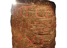
A Roman milestone was discovered in 1862 in the
Silverlands district of Buxton. It is the oldest inscribed milestone found in Derbyshire. The inscription is ‘TRIB POT COS II P P A NAVIONE M P XI’ which means ‘With the
434:
137:
has suggested this as the route of the lost Roman road. The feature, which extends through Barber Fields, is 20m wide and filled to a depth of 5m with rubble and has a metalled surface.
321:
244:
110:
he said that evidence is now available that shows that after the
Redmires Reservoir the Roman road did not follow the medieval route to
118:
half a mile north-west of the present route, on a narrow and steeper terrace. Batham Gate Road was assigned the
Margary number RR710a.
512:
366:
332:
217:
278:
361:
121:
Another possible route, backed by excavations carried out in 2016, suggests a route that would have taken the road close to the
497:
502:
233:
189:
507:
80:
45:
140:
458:
130:
171:
402:
161:
103:
88:
445:
153:
164:, near Brough, which are remnants of the route of the original Roman road. The section crossing
114:
but kept to the line of the present-day track to
Stanedge Lodge. The Roman road then descended
274:
213:
126:
76:
means "road" in northern
English dialects; the name therefore means "road to the bath town".
357:
68:
58:
441:
92:
49:
106:
said that the Long
Causeway had a slightly different route in Roman times. In his book
79:
The route of the road from
Templebrough to the Roman signal station Navio is disputed.
491:
165:
111:
84:
53:
188:, father of this country. From Navio 11 miles.' The milestone is on display in the
115:
41:
25:
Batham Gate: the modern road follows the line of the Roman road near
Laughman Tor
149:
122:
134:
37:
33:
473:
460:
157:
96:
295:
450:
21:
429:
181:
133:
staff on excavations of a linear feature in the
Sheephill Road area of
185:
63:
170:
139:
20:
175:
Inscription on Roman milestone found at
Silverlands, Buxton
451:
Geograph image of Batham Gate Roman road, near Peak Forest
156:. There are also modern roads called Batham Gate Road at
212:. Five Leaves Publications. pp. 219–221, 239–242.
95:
maps, but this is now known to be a medieval packhorse
391:(Map). 1:25000. Explorer. Ordnance Survey. West sheet.
8:
144:Route of Batham Gate Road near Peak Forest
91:as the route and it was shown as such on
200:
273:. Moorland Publishing Co. p. 38.
148:A section of Batham Gate Road east of
250:from the original on 9 September 2018
40:, England, which ran south-west from
7:
362:"Batham Gate, Roman road (1007051)"
367:National Heritage List for England
14:
285:Gives details of Roman deviation.
16:Roman road in Derbyshire, England
329:Roman Roads Research Association
296:"OS Roman Road Files (Margary)"
320:Inglis, D. H. (January 2016).
234:"Long Causway Management Plan"
1:
403:"Roman Buxton – Silverlands"
271:Peakland Roads and Trackways
168:is now called Clement Lane.
407:www.wondersofthepeak.org.uk
241:Peak District National Park
32:is the medieval name for a
529:
513:Roman sites in Derbyshire
444:showing Batham Gate near
440:20 September 2015 at the
322:"The Roman Road Project"
208:Patterson, Mark (2016).
269:Dodd, A.E.; Dodd, E.M.
131:University of Sheffield
129:. An interim report by
498:Roman roads in England
176:
160:, near Buxton, and at
145:
108:Roman Roads In Britain
62:) and the spa town of
26:
503:History of Derbyshire
174:
143:
102:Roman road historian
24:
389:OL24 White Peak area
508:Roads in Derbyshire
470: /
435:Ordnance survey Map
338:on 9 September 2018
104:Ivan Donald Margary
474:53.2809°N 1.8851°W
300:www.romanroads.org
177:
154:Scheduled Monument
146:
27:
430:About Batham Gate
127:Whirlow Hall Farm
72:) in Derbyshire.
520:
485:
484:
482:
481:
480:
479:53.2809; -1.8851
475:
471:
468:
467:
466:
463:
418:
417:
415:
413:
399:
393:
392:
385:
379:
378:
376:
374:
358:Historic England
354:
348:
347:
345:
343:
337:
331:. Archived from
326:
317:
311:
310:
308:
306:
292:
286:
284:
266:
260:
259:
257:
255:
249:
238:
230:
224:
223:
210:Roman Derbyshire
205:
184:'s power, twice
69:Aquae Arnemetiae
528:
527:
523:
522:
521:
519:
518:
517:
488:
487:
478:
476:
472:
469:
464:
461:
459:
457:
456:
442:Wayback Machine
426:
421:
411:
409:
401:
400:
396:
387:
386:
382:
372:
370:
356:
355:
351:
341:
339:
335:
324:
319:
318:
314:
304:
302:
294:
293:
289:
281:
268:
267:
263:
253:
251:
247:
236:
232:
231:
227:
220:
207:
206:
202:
198:
152:is a protected
93:Ordnance Survey
50:South Yorkshire
17:
12:
11:
5:
526:
524:
516:
515:
510:
505:
500:
490:
489:
454:
453:
448:
432:
425:
424:External links
422:
420:
419:
394:
380:
349:
312:
287:
279:
261:
225:
219:978-1910170250
218:
199:
197:
194:
83:suggested the
15:
13:
10:
9:
6:
4:
3:
2:
525:
514:
511:
509:
506:
504:
501:
499:
496:
495:
493:
486:
483:
452:
449:
447:
443:
439:
436:
433:
431:
428:
427:
423:
408:
404:
398:
395:
390:
384:
381:
369:
368:
363:
359:
353:
350:
334:
330:
323:
316:
313:
301:
297:
291:
288:
282:
280:0 86190 004 9
276:
272:
265:
262:
246:
242:
235:
229:
226:
221:
215:
211:
204:
201:
195:
193:
191:
190:Buxton Museum
187:
183:
173:
169:
167:
166:Bradwell Moor
163:
159:
155:
151:
142:
138:
136:
132:
128:
124:
119:
117:
113:
112:Stanedge Pole
109:
105:
100:
98:
94:
90:
86:
85:Long Causeway
82:
77:
75:
71:
70:
65:
61:
60:
55:
54:Brough-on-Noe
51:
47:
43:
39:
35:
31:
23:
19:
455:
410:. Retrieved
406:
397:
388:
383:
373:24 September
371:. Retrieved
365:
352:
340:. Retrieved
333:the original
328:
315:
305:24 September
303:. Retrieved
299:
290:
270:
264:
252:. Retrieved
240:
228:
209:
203:
178:
147:
120:
116:Stanage Edge
107:
101:
78:
73:
67:
57:
42:Templebrough
29:
28:
18:
477: /
150:Peak Forest
123:Roman villa
30:Batham Gate
492:Categories
462:53°16′51″N
342:4 December
254:3 December
196:References
135:Ringinglow
38:Derbyshire
34:Roman road
465:1°53′06″W
158:Peak Dale
46:River Don
438:Archived
245:Archived
243:. 2008.
162:Bradwell
89:Redmires
412:4 April
182:tribune
97:saltway
66:(Latin
56:(Latin
44:on the
446:Brough
277:
216:
186:consul
81:Hunter
64:Buxton
336:(PDF)
325:(PDF)
248:(PDF)
237:(PDF)
59:Navio
414:2020
375:2020
344:2017
307:2020
275:ISBN
256:2017
214:ISBN
74:Gate
125:at
87:at
52:to
48:in
36:in
494::
405:.
364:.
360:.
327:.
298:.
239:.
192:.
99:.
416:.
377:.
346:.
309:.
283:.
258:.
222:.
Text is available under the Creative Commons Attribution-ShareAlike License. Additional terms may apply.