631:
215:
61:
82:
68:
39:
317:, from west to east only. At Roslyn Street, through traffic is not permitted, with all traffic directed north on Roslyn Street. East of the junction of Roslyn Street and Bayswater Road, southbound traffic on Roslyn Street is also directed one way, east, on Bayswater Road. From this point Bayswater Road
332:
The western end of the street is lined with nightspots, eateries, adult venues, dance clubs hotels, and is a popular destination for both
Sydneysiders and tourists. It is considered to be a more upmarket precinct of Kings Cross, when compared with Darlingurst Road.
752:
An Act to amend the Main Roads Act, 1924-1927; to confer certain further powers upon the Main Roads Board; to amend the Local
Government Act, 1919, and certain other Acts; to validate certain payments and other matters; and for purposes connected
799:
775:
An Act to make provision with respect to the roads of New South Wales; to repeal the State Roads Act 1986, the Crown and Other Roads Act 1990 and certain other enactments; and for other purposes.
862:
376:
updated road classifications and the way they could be declared within New South Wales. Under this act, William Street retains its declaration as part of Main Road 173.
668:
806:
730:
An Act to provide for the better construction, maintenance, and financing of main roads; to provide for developmental roads; to constitute a Main Roads Board
109:
142:
362:
855:
778:
733:
1335:
848:
369:
further west along
Bayswater Road to William Street (and continuing west along William Street towards Woolloomooloo) on 2 December 1964.
756:
60:
1174:
706:
539:
499:
479:
458:
543:
560:
520:
483:
448:
346:
1139:
1078:
581:
470:
444:
432:
391:
286:
100:
47:
1068:
573:
1330:
893:
547:
1058:
577:
533:
1023:
1018:
963:
943:
938:
903:
635:
1088:
948:
495:
322:
252:
1299:
1274:
1179:
1073:
1038:
1028:
998:
968:
908:
898:
772:
349:
provided for the declaration of Main Roads, roads partially funded by the State government through the
38:
313:
where, east of Ward Avenue and west of Roslyn Street, vehicular traffic in the street able to head in
1284:
1219:
1164:
1109:
953:
727:
1239:
1229:
1114:
1093:
1063:
1043:
1013:
1008:
1003:
569:
366:
326:
263:
1254:
1189:
1149:
993:
923:
599:
505:
380:
379:
The route was allocated State Route 76 through
Rushcutters Bay in 1976, after the opening of the
318:
840:
1289:
1214:
1194:
1169:
933:
795:
354:
749:
1294:
1269:
1244:
1204:
983:
973:
918:
350:
630:
1264:
1249:
1124:
978:
928:
876:
782:
760:
737:
387:
314:
310:
294:
269:
29:
1259:
1224:
1209:
1184:
1154:
1144:
1129:
1083:
1048:
885:
698:
641:
529:
427:
198:
1324:
1309:
1234:
1119:
988:
1304:
1199:
1033:
610:
365:(having succeeded the MRB in 1932) extended the western end of Main Road 173 from
1159:
1053:
958:
673:
306:
241:
1134:
705:. No. 137. National Library of Australia. 4 December 1964. p. 3910.
361:
to provide for additional declarations of State
Highways and Trunk Roads, the
157:
144:
124:
111:
1279:
394:
once ran down the thoroughfare, this was closed in 1960, replaced by buses.
305:
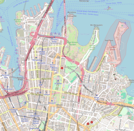
Bayswater Road commences at the intersection with
Darlinghurst Road in
872:
290:
282:
844:
558:
518:
494:
325:
and, adjacent to
Rushcutters Bay Park, the street continues as
800:"Schedule of Classified Roads and Unclassified Regional Roads"
568:
442:
309:
and heads east over a short rise and down a hill towards
1102:
884:
564:
524:
503:
258:
248:
232:
227:
207:
197:
189:
181:
176:
99:
23:
703:Government Gazette of the State of New South Wales
585:
519:MacLachlan Avenue (one-way northbound) –
452:
805:. Government of New South Wales. Archived from
469:Roslyn Street (one-way southbound) –
856:
693:
691:
559:Neild Avenue (one-way southbound) –
405:
383:, but was completely decommissioned in 2004.
8:
863:
849:
841:
401:
281:is a 700-metre-long (2,300 ft) minor
37:
20:
663:
661:
659:
657:
653:
357:). With the subsequent passing of the
552:
512:
488:
468:
462:
436:
7:
359:Main Roads (Amendment) Act of 1929
14:
709:from the original on 15 May 2023
629:
213:
81:
80:
67:
66:
59:
498:(one-way eastbound) –
1:
834:. Transit Press: Sydney, p. 2
443:Darlinghurst Road –
347:Parliament of New South Wales
1336:Kings Cross, New South Wales
1140:Burnt Bridge Creek Deviation
699:"Main Roads Act, 1924-1963"
636:Australian Roads portal
16:Street in Sydney, Australia
1352:
773:State of New South Wales,
750:State of New South Wales,
728:State of New South Wales,
590:
555:
538:
528:
515:
491:
478:
474:
465:
457:
439:
431:
426:
421:
418:
415:
412:
409:
404:
222:(through Rushcutters Bay)
54:
45:
36:
606:
595:
586:Eastern terminus of road
453:Western terminus of road
363:Department of Main Roads
193:700 m (0.4 mi)
158:33.876215°S 151.226860°E
125:33.874768°S 151.222531°E
504:Eastbound traffic from
270:Rushcutters Bay, Sydney
781:11 August 2022 at the
759:12 August 2022 at the
736:11 August 2022 at the
343:Main Roads Act of 1924
163:-33.876215; 151.226860
130:-33.874768; 151.222531
1180:Great Western Highway
1285:Southern Cross Drive
1165:General Holmes Drive
1240:Old South Head Road
1230:New South Head Road
830:Keenan, D. (1979),
570:New South Head Road
398:Major intersections
372:The passing of the
367:New South Head Road
341:The passing of the
327:New South Head Road
264:New South Head Road
242:Potts Point, Sydney
177:General information
154: /
121: /
1255:Pennant Hills Road
1190:Henry Lawson Drive
1150:Cumberland Highway
924:Castlereagh Street
832:Tramways of Sydney
506:Kings Cross Tunnel
381:Kings Cross Tunnel
46:Bayswater Road in
1331:Streets in Sydney
1318:
1317:
1290:Syd Einfeld Drive
1215:King Georges Road
1195:The Horsley Drive
1170:Gore Hill Freeway
812:on 25 August 2022
796:Transport for NSW
621:
620:
600:Incomplete access
374:Roads Act of 1993
355:Transport for NSW
315:one way direction
276:
275:
237:Darlinghurst Road
1343:
1295:Taren Point Road
1270:Prospect Highway
1245:Old Windsor Road
1205:James Ruse Drive
1175:Great North Road
1024:Macquarie Street
1019:Liverpool Street
984:Grosvenor Street
974:Glebe Point Road
964:Elizabeth Street
944:Cleveland Street
865:
858:
851:
842:
835:
828:
822:
821:
819:
817:
811:
804:
792:
786:
785:10 November 1924
770:
764:
747:
741:
740:10 November 1924
725:
719:
718:
716:
714:
695:
686:
685:
683:
681:
669:"Bayswater Road"
665:
634:
633:
614:
607:
602:
596:
407:
402:
388:electric tramway
351:Main Roads Board
272:
244:
223:
217:
216:
169:
168:
166:
165:
164:
159:
155:
152:
151:
150:
147:
136:
135:
133:
132:
131:
126:
122:
119:
118:
117:
114:
84:
83:
70:
69:
63:
41:
21:
1351:
1350:
1346:
1345:
1344:
1342:
1341:
1340:
1321:
1320:
1319:
1314:
1265:Princes Highway
1250:Parramatta Road
1125:Barrenjoey Road
1098:
1079:Victoria Street
979:Goulburn Street
939:Clarence Street
929:Chalmers Street
904:Bathurst Street
880:
877:New South Wales
869:
839:
838:
829:
825:
815:
813:
809:
802:
798:(August 2022).
794:
793:
789:
783:Wayback Machine
771:
767:
761:Wayback Machine
748:
744:
738:Wayback Machine
726:
722:
712:
710:
697:
696:
689:
679:
677:
667:
666:
655:
650:
628:
626:
617:
609:
605:
598:
594:
540:Rushcutters Bay
500:Rushcutters Bay
480:Rushcutters Bay
459:Rushcutters Bay
400:
339:
311:Rushcutters Bay
303:
295:New South Wales
268:
267:
240:
239:
228:Major junctions
221:
219:
218:State Route 76
214:
209:
170: (East end)
162:
160:
156:
153:
148:
145:
143:
141:
140:
137: (West end)
129:
127:
123:
120:
115:
112:
110:
108:
107:
95:
94:
93:
92:
91:
90:
89:
85:
77:
76:
75:
71:
32:
30:New South Wales
27:
26:
17:
12:
11:
5:
1349:
1347:
1339:
1338:
1333:
1323:
1322:
1316:
1315:
1313:
1312:
1307:
1302:
1297:
1292:
1287:
1282:
1277:
1272:
1267:
1262:
1260:Pittwater Road
1257:
1252:
1247:
1242:
1237:
1232:
1227:
1225:Lane Cove Road
1222:
1217:
1212:
1210:Jeffrey Street
1207:
1202:
1197:
1192:
1187:
1185:Heathcote Road
1182:
1177:
1172:
1167:
1162:
1157:
1155:Darling Street
1152:
1147:
1145:City West Link
1142:
1137:
1132:
1130:Blacktown Road
1127:
1122:
1117:
1112:
1106:
1104:
1103:Suburban roads
1100:
1099:
1097:
1096:
1091:
1089:William Street
1086:
1084:Whitlam Square
1081:
1076:
1071:
1069:Stanley Street
1066:
1061:
1059:Queen's Square
1056:
1051:
1049:Phillip Street
1046:
1041:
1036:
1031:
1026:
1021:
1016:
1011:
1006:
1001:
996:
991:
986:
981:
976:
971:
966:
961:
956:
951:
949:College Street
946:
941:
936:
931:
926:
921:
916:
914:Bayswater Road
911:
906:
901:
896:
890:
888:
886:City of Sydney
882:
881:
870:
868:
867:
860:
853:
845:
837:
836:
823:
787:
765:
742:
720:
687:
652:
651:
649:
646:
645:
644:
642:City of Sydney
625:
622:
619:
618:
616:
615:
603:
591:
588:
587:
584:
566:
565:
563:
557:
554:
551:
537:
526:
525:
523:
517:
514:
510:
509:
502:
496:William Street
493:
490:
487:
476:
475:
473:
467:
464:
461:
455:
454:
451:
441:
438:
435:
430:
424:
423:
420:
417:
414:
411:
408:
399:
396:
338:
335:
323:William Street
302:
299:
279:Bayswater Road
274:
273:
260:
256:
255:
253:William Street
250:
246:
245:
234:
230:
229:
225:
224:
211:
205:
204:
201:
195:
194:
191:
187:
186:
183:
179:
178:
174:
173:
172:
171:
138:
103:
97:
96:
87:
86:
79:
78:
73:
72:
65:
64:
58:
57:
56:
55:
52:
51:
43:
42:
34:
33:
28:
25:Bayswater Road
24:
15:
13:
10:
9:
6:
4:
3:
2:
1348:
1337:
1334:
1332:
1329:
1328:
1326:
1311:
1310:Wolseley Road
1308:
1306:
1303:
1301:
1300:Victoria Road
1298:
1296:
1293:
1291:
1288:
1286:
1283:
1281:
1278:
1276:
1275:Richmond Road
1273:
1271:
1268:
1266:
1263:
1261:
1258:
1256:
1253:
1251:
1248:
1246:
1243:
1241:
1238:
1236:
1235:Norton Street
1233:
1231:
1228:
1226:
1223:
1221:
1218:
1216:
1213:
1211:
1208:
1206:
1203:
1201:
1198:
1196:
1193:
1191:
1188:
1186:
1183:
1181:
1178:
1176:
1173:
1171:
1168:
1166:
1163:
1161:
1158:
1156:
1153:
1151:
1148:
1146:
1143:
1141:
1138:
1136:
1133:
1131:
1128:
1126:
1123:
1121:
1120:Bangor Bypass
1118:
1116:
1113:
1111:
1108:
1107:
1105:
1101:
1095:
1092:
1090:
1087:
1085:
1082:
1080:
1077:
1075:
1074:Sussex Street
1072:
1070:
1067:
1065:
1062:
1060:
1057:
1055:
1052:
1050:
1047:
1045:
1042:
1040:
1039:Oxford Street
1037:
1035:
1032:
1030:
1029:Market Street
1027:
1025:
1022:
1020:
1017:
1015:
1012:
1010:
1007:
1005:
1002:
1000:
999:Hunter Street
997:
995:
992:
990:
989:Harris Street
987:
985:
982:
980:
977:
975:
972:
970:
969:George Street
967:
965:
962:
960:
957:
955:
952:
950:
947:
945:
942:
940:
937:
935:
932:
930:
927:
925:
922:
920:
917:
915:
912:
910:
909:Bridge Street
907:
905:
902:
900:
899:Alfred Street
897:
895:
894:Albion Street
892:
891:
889:
887:
883:
878:
874:
866:
861:
859:
854:
852:
847:
846:
843:
833:
827:
824:
808:
801:
797:
791:
788:
784:
780:
777:
776:
769:
766:
762:
758:
755:
754:
746:
743:
739:
735:
732:
731:
724:
721:
708:
704:
700:
694:
692:
688:
676:
675:
670:
664:
662:
660:
658:
654:
647:
643:
640:
639:
638:
637:
632:
623:
612:
604:
601:
593:
592:
589:
583:
579:
575:
571:
567:
562:
549:
545:
544:Darling Point
541:
535:
531:
527:
522:
511:
507:
501:
497:
485:
481:
477:
472:
460:
456:
450:
446:
434:
429:
425:
403:
397:
395:
393:
389:
384:
382:
377:
375:
370:
368:
364:
360:
356:
352:
348:
344:
336:
334:
330:
328:
324:
320:
316:
312:
308:
300:
298:
297:, Australia.
296:
292:
288:
284:
280:
271:
266:
265:
261:
257:
254:
251:
247:
243:
238:
235:
231:
226:
212:
206:
203:December 1964
202:
200:
196:
192:
188:
184:
180:
175:
167:
139:
134:
106:
105:
104:
102:
98:
62:
53:
49:
44:
40:
35:
31:
22:
19:
1305:Windsor Road
1200:Hume Highway
1110:Anzac Parade
1034:Martin Place
954:Crown Street
913:
831:
826:
814:. Retrieved
807:the original
790:
774:
768:
763:8 April 1929
751:
745:
729:
723:
711:. Retrieved
702:
678:. Retrieved
672:
627:
608:
597:
572: –
561:Darlinghurst
521:Darlinghurst
484:Darlinghurst
449:Darlinghurst
419:Destinations
385:
378:
373:
371:
358:
353:(MRB, later
345:through the
342:
340:
331:
304:
289:district of
278:
277:
262:
236:
210:route number
18:
1220:King Street
1160:Epping Road
1094:York Street
1064:Rowe Street
1054:Pitt Street
1044:Park Street
1014:Lime Street
1009:King Street
1004:Kent Street
959:Eddy Avenue
879:, Australia
871:Streets of
674:Google Maps
582:Watsons Bay
471:Kings Cross
445:Kings Cross
433:Potts Point
392:Watsons Bay
307:Potts Point
287:Kings Cross
220:(1976–2004)
161: /
149:151°13′37″E
128: /
116:151°13′21″E
101:Coordinates
48:Kings Cross
1325:Categories
1135:Bondi Road
1115:Appian Way
994:Hay Street
753:therewith.
648:References
613:transition
574:Double Bay
146:33°52′34″S
113:33°52′29″S
1280:Ryde Road
934:City Road
548:Edgecliff
534:Woollahra
919:Broadway
816:1 August
779:Archived
757:Archived
734:Archived
707:Archived
624:See also
578:Vaucluse
550:tripoint
536:boundary
486:boundary
410:Location
259:East end
233:West end
199:Gazetted
88:East end
74:West end
671:(Map).
386:A busy
337:History
285:in the
50:in 1929
873:Sydney
713:31 May
680:31 May
530:Sydney
428:Sydney
319:merges
291:Sydney
283:street
249:
208:Former
190:Length
185:Street
810:(PDF)
803:(PDF)
611:Route
422:Notes
321:with
301:Route
818:2022
715:2023
682:2023
556:0.43
516:0.37
508:only
492:0.25
466:0.19
182:Type
553:0.7
513:0.6
489:0.4
463:0.3
440:0.0
437:0.0
406:LGA
390:to
1327::
875:,
701:.
690:^
656:^
580:,
576:,
447:,
416:mi
413:km
329:.
293:,
864:e
857:t
850:v
820:.
717:.
684:.
546:–
542:–
532:–
482:–
Text is available under the Creative Commons Attribution-ShareAlike License. Additional terms may apply.