1020:
39:
981:
1008:
993:
749:
1052:
1342:
799:
744:
709:
223:
61:
1563:
82:
68:
496:
With the combination of trams, buses and cars, the
William Street, Darlinghurst Road and Victoria Street junction (Kings Cross) became one of Sydney's busiest intersections and worst bottlenecks. The tram line on William Street and through Kings Cross was closed on 10 July 1960, superseded by buses and later, the
495:
was opened in 1894 travelling along
William Street and operated until circa 1901. Tram services were electrified in 1905. Motor buses were introduced after World War I. During the 1930s, the tram service from William Street through Kings Cross ran as frequently as one tram per minute during weekdays.
1019:
1388:
An Act to amend the Main Roads Act, 1924-1927; to confer certain further powers upon the MRB; to amend the Local
Government Act, 1919, and certain other Acts; to validate certain payments and other matters; and for purposes connected
1510:
An Act to make provision with respect to the roads of New South Wales; to repeal the State Roads Act 1986, the Crown and Other Roads Act 1990 and certain other enactments; and for other purposes.
542:
and required the resumption and demolition of 118 properties. It was opened on 15 December 1975. In
November 1987, a tunnel opened beneath William Street to carry traffic coming off the
1624:
561:
updated road classifications and the way they could be declared within New South Wales. Under this act, William Street retains its declaration as part of Main Road 173.
445:. In 1909 it was decided to resume the south side of the street to widen the street into a larger boulevard style. The resuming was conducted between 1910 and 1914.
527:
further west along
William Street to its intersection with Palmer Street in Woolloomooloo on 2 December 1964, and eventually again further to the intersection with
1235:
1534:
434:
wanted the street to be further to the south, but whilst he was away exploring the interior of
Australia, the street was constructed in its present location.
1366:
An Act to provide for the better construction, maintenance, and financing of main roads; to provide for developmental roads; to constitute a Main Roads Board
109:
142:
520:
1617:
980:
1230:
1116:
538:
sits at the eastern end of
William Street extending the carriageway to Rushcutters Bay. The cut and cover tunnel was constructed as part of the
2097:
1513:
1369:
2102:
523:(having succeeded the MRB in 1932) extended the western end of Main Road 173 from its old terminus at the intersection of William Street and
362:
and heads in an easterly direction as a four-lane, single carriageway road, widening into a dual-carriageway road just before it enters the
1610:
1392:
992:
488:
1479:
1007:
60:
1936:
1417:
1154:
1567:
885:
837:
810:
359:
249:
1257:
1177:
1593:
1225:
733:
698:
677:
657:
427:
401:. The tunnel was constructed in an attempt to ease traffic congestion for through traffic across the east-west of the CBD.
890:
869:
833:
820:
806:
793:
772:
737:
716:
661:
610:
508:
38:
1901:
1840:
1030:
919:
903:
864:
815:
802:
789:
776:
702:
681:
539:
497:
398:
273:
100:
1830:
1585:
911:
1439:
1078:
2092:
1655:
853:
644:
442:
441:
lived in a boarding house along
William Street before he became famous for his poetry and also wrote a poem titled
431:
1283:
1820:
915:
1785:
1780:
1725:
1705:
1465:
648:
472:
1700:
1665:
1056:
756:
1710:
1675:
1034:
899:
636:
367:
351:
300:
263:
2061:
2036:
1941:
1835:
1800:
1790:
1760:
1730:
1670:
1660:
1507:
580:
480:
511:
provided for the declaration of Main Roads, roads partially funded by the State government through the
2046:
1981:
1926:
1871:
1715:
673:
528:
268:
1363:
2001:
1991:
1876:
1855:
1825:
1805:
1775:
1770:
1765:
1346:
1323:
1037:
907:
752:
712:
622:
551:
524:
371:
347:
294:
243:
47:
2016:
1951:
1911:
1755:
1685:
937:
826:
565:
535:
405:
363:
1602:
1350:
1341:
426:
in the 1830s to allow traffic to and from the fashionable and expensive
Eastern suburbs around
2051:
1976:
1956:
1931:
1695:
1589:
1530:
999:
849:
543:
390:
355:
281:
1385:
2056:
2031:
2006:
1966:
1745:
1735:
1680:
512:
471:, William Street was the bustling centre of Sydney's automotive trade, with Yorks Motors in
1051:
2026:
2011:
1886:
1740:
1690:
1638:
1517:
1396:
1373:
492:
476:
375:
327:
306:
29:
422:
William Street was built through the farm land of the valley between the city centre and
2021:
1986:
1971:
1946:
1916:
1906:
1891:
1845:
1810:
1647:
1409:
1146:
1089:
760:
577:
206:
2086:
2071:
1996:
1881:
1750:
547:
452:
and nightclubs, including the Strand Hotel, the Prince Albert Hotel and the infamous
379:
2066:
1961:
1795:
1026:
959:
468:
457:
438:
408:
394:
383:
1226:"Mixed Residential and Commercial Building "William House" (101-111 William Stree"
1921:
1815:
1720:
1121:
464:
423:
1416:. No. 7. National Library of Australia. 22 January 1993. pp. 223–30.
1896:
1153:. No. 137. National Library of Australia. 4 December 1964. p. 3910.
640:
626:
606:
519:
to provide for additional declarations of State
Highways and Trunk Roads, the
397:, follows much of the route of William Street and extends further west to the
335:
338:
of the United Kingdom of Great Britain and Ireland upon its opening in 1834.
157:
144:
124:
111:
2041:
948:
331:
1562:
1083:
564:
The route was allocated State Route 76 in 1976, after the opening of the
484:
487:
cars in 1932. William Street also once housed recording studios for the
411:
1634:
323:
366:, before ending at the junction with Barcom Avenue, Waratah Street,
378:. The street runs along the border for between the two suburbs of
319:
1606:
1203:
731:
696:
672:
1535:"Schedule of Classified Roads and Unclassified Regional Roads"
1258:"Past and Present: Corner of William Street and Kirketon Road"
898:
621:
449:
448:
In the 1930s, William Street was the location of a number of
1480:"The Eastern Distributor Stage 1 – William Street Underpass"
848:
767:
No right turn northbound or southbound from Bourke Street
686:
No right turn eastbound or westbound into Crown Street
404:
William Street is closed to vehicular traffic for the
1864:
1646:
764:
720:
685:
289:
256:
238:
233:
215:
205:
197:
189:
181:
176:
99:
23:
1414:Government Gazette of the State of New South Wales
1151:Government Gazette of the State of New South Wales
923:
630:
863:Kings Cross Road (one-way eastbound) –
814:Kings Cross Road (one-way eastbound) –
576:William Street is entirely contained within the
346:William Street commences at the intersection of
1582:Faces of the Street: William Street Sydney 1916
884:Waratah Street (one-way northbound) –
868:Craigend Street (one-way westbound) –
857:
819:Craigend Street (one-way westbound) –
889:Barcom Street (one-way southbound) –
1618:
1141:
1139:
568:, but was completely decommissioned in 2004.
318:is a 1.4-kilometre-long (0.87 mi) major
8:
1625:
1611:
1603:
1489:. New South Wales Department of Main Roads
765:No right turn eastbound into Bourke Street
721:No right turn eastbound into Palmer Street
585:
515:(MRB). With the subsequent passing of the
37:
20:
1073:
1071:
334:. The street was named in honour of king
986:William Street from the air in the 1950s
1178:"Sydney's Razor Gang Wars 1925 to 1935"
1111:
1109:
1107:
1067:
1013:William Street as seen from Kings Cross
976:
1349: by Mark Dunn available under the
858:Western entrance and eastern exit only
430:. Originally the NSW Surveyor-General
1288:Heritage, Roads and Traffic Authority
883:
877:
862:
842:
787:
781:
725:
690:
666:
635:
615:
456:, where sex workers were provided by
437:In the 1880s notable Australian poet
7:
1463:Eastern suburbs link to open early
1176:Whitaker, Dick (20 November 2011).
414:and race, held in August annually.
1420:from the original on 27 March 2023
517:Main Roads (Amendment) Act of 1929
489:Australian Broadcasting Commission
14:
1264:. Violet Tingle. 10 February 2012
1238:from the original on 7 April 2021
1561:
1345: This article incorporates
1340:
1157:from the original on 15 May 2023
1050:
1018:
1006:
991:
979:
805:(one-way southbound) –
797:
747:
742:
707:
550:, as part of the Stage 1 of the
360:Sydney central business district
221:
81:
80:
67:
66:
59:
1540:. Government of New South Wales
1290:. Government of New South Wales
910:(one-way westbound) –
902:(one-way eastbound) –
1:
2098:Darlinghurst, New South Wales
1312:. Transit Press: Sydney, p. 2
788:Darlinghurst Road –
509:Parliament of New South Wales
2103:Kings Cross, New South Wales
1902:Burnt Bridge Creek Deviation
1324:"Kings Cross: Getting there"
540:Eastern Suburbs railway line
498:Eastern Suburbs railway line
1147:"Main Roads Act, 1924-1963"
1079:"History of Sydney streets"
1057:Australian roads portal
2119:
1508:State of New South Wales,
1386:State of New South Wales,
1364:State of New South Wales,
924:Eastern terminus of street
631:Western terminus of street
463:During the period between
928:
894:
880:
873:
845:
832:
824:
784:
771:
732:Bourke Street –
728:
697:Palmer Street –
693:
669:
656:
652:
618:
605:
600:
597:
594:
591:
588:
193:1.4 km (0.9 mi)
54:
45:
36:
16:Road in Sydney, Australia
1231:State Heritage Inventory
1206:. The Malouf Group. 2015
1033:, Darlinghurst Road and
955:
944:
933:
521:Department of Main Roads
493:Watsons Bay tram service
386:for most of its length.
158:33.876670°S 151.227222°E
125:33.873683°S 151.212588°E
46:William Street with the
1469:10 February 1987 page 9
1284:"Drain Grate, Rose Bay"
354:on the eastern edge of
307:Rushcutters Bay, Sydney
1568:William Street, Sydney
1516:11 August 2022 at the
1395:12 August 2022 at the
1372:11 August 2022 at the
755:(M1 south) –
715:(M1 north) –
505:Main Roads Act of 1924
163:-33.876670; 151.227222
130:-33.873683; 151.212588
1942:Great Western Highway
1570:at Wikimedia Commons
1440:"King's Cross Tunnel"
811:St Vincent's Hospital
581:local government area
2047:Southern Cross Drive
1927:General Holmes Drive
1328:Dictionary of Sydney
1086:(requires download))
1025:William Street from
998:William Street near
531:on 22 January 1993.
2002:Old South Head Road
1992:New South Head Road
1588:, NSW: Doak Press.
1580:Kelly, Max (1982).
1308:Keenan, D. (1979),
1038:diamond interchange
908:New South Head Road
753:Eastern Distributor
713:Eastern Distributor
572:Major intersections
557:The passing of the
552:Eastern Distributor
525:New South Head Road
503:The passing of the
475:set up as the sole
399:Western Distributor
372:New South Head Road
295:New South Head Road
177:General information
154: /
121: /
48:Coca-Cola billboard
2017:Pennant Hills Road
1952:Henry Lawson Drive
1912:Cumberland Highway
1686:Castlereagh Street
1310:Tramways of Sydney
827:Kings Cross Tunnel
825:Western portal of
566:Kings Cross Tunnel
536:Kings Cross Tunnel
364:Kings Cross Tunnel
2093:Streets in Sydney
2080:
2079:
2052:Syd Einfeld Drive
1977:King Georges Road
1957:The Horsley Drive
1932:Gore Hill Freeway
1566:Media related to
1531:Transport for NSW
1487:Expressway.online
1410:"State Roads Act"
1262:Darlinghurst Blog
1204:"Grenville house"
1092:. 4 December 2012
1000:Australian Museum
970:
969:
938:Incomplete access
850:Cross City Tunnel
559:Roads Act of 1993
544:Cahill Expressway
391:Cross City Tunnel
313:
312:
282:Cross City Tunnel
2110:
2057:Taren Point Road
2032:Prospect Highway
2007:Old Windsor Road
1967:James Ruse Drive
1937:Great North Road
1786:Macquarie Street
1781:Liverpool Street
1746:Grosvenor Street
1736:Glebe Point Road
1726:Elizabeth Street
1706:Cleveland Street
1627:
1620:
1613:
1604:
1599:
1565:
1550:
1549:
1547:
1545:
1539:
1527:
1521:
1520:10 November 1924
1505:
1499:
1498:
1496:
1494:
1484:
1476:
1470:
1461:
1455:
1454:
1452:
1450:
1436:
1430:
1429:
1427:
1425:
1406:
1400:
1383:
1377:
1376:10 November 1924
1361:
1355:
1344:
1338:
1336:
1334:
1319:
1313:
1306:
1300:
1299:
1297:
1295:
1280:
1274:
1273:
1271:
1269:
1254:
1248:
1247:
1245:
1243:
1222:
1216:
1215:
1213:
1211:
1200:
1194:
1193:
1191:
1189:
1173:
1167:
1166:
1164:
1162:
1143:
1134:
1133:
1131:
1129:
1117:"William Street"
1113:
1102:
1101:
1099:
1097:
1087:
1075:
1055:
1054:
1022:
1010:
995:
983:
963:
956:
951:
945:
940:
934:
801:
800:
751:
750:
746:
745:
711:
710:
586:
513:Main Roads Board
454:Fifty-Fifty Club
309:
252:
229:
225:
224:
169:
168:
166:
165:
164:
159:
155:
152:
151:
150:
147:
136:
135:
133:
132:
131:
126:
122:
119:
118:
117:
114:
84:
83:
70:
69:
63:
41:
21:
2118:
2117:
2113:
2112:
2111:
2109:
2108:
2107:
2083:
2082:
2081:
2076:
2027:Princes Highway
2012:Parramatta Road
1887:Barrenjoey Road
1860:
1841:Victoria Street
1741:Goulburn Street
1701:Clarence Street
1691:Chalmers Street
1666:Bathurst Street
1642:
1639:New South Wales
1631:
1596:
1579:
1576:
1574:Further reading
1559:
1554:
1553:
1543:
1541:
1537:
1533:(August 2022).
1529:
1528:
1524:
1518:Wayback Machine
1506:
1502:
1492:
1490:
1482:
1478:
1477:
1473:
1466:Daily Telegraph
1462:
1458:
1448:
1446:
1438:
1437:
1433:
1423:
1421:
1408:
1407:
1403:
1397:Wayback Machine
1384:
1380:
1374:Wayback Machine
1362:
1358:
1332:
1330:
1321:
1320:
1316:
1307:
1303:
1293:
1291:
1282:
1281:
1277:
1267:
1265:
1256:
1255:
1251:
1241:
1239:
1224:
1223:
1219:
1209:
1207:
1202:
1201:
1197:
1187:
1185:
1184:. Dick Whitaker
1175:
1174:
1170:
1160:
1158:
1145:
1144:
1137:
1127:
1125:
1115:
1114:
1105:
1095:
1093:
1081:
1077:
1076:
1069:
1064:
1049:
1047:
1040:
1031:Victoria Street
1023:
1014:
1011:
1002:
996:
987:
984:
975:
966:
958:
954:
947:
943:
936:
932:
906:
888:
886:Rushcutters Bay
867:
838:Rushcutters Bay
818:
813:
803:Victoria Street
798:
796:
766:
748:
743:
740:
708:
705:
574:
479:distributor of
477:New South Wales
432:Thomas Mitchell
420:
395:tolled motorway
376:Rushcutters Bay
352:College Streets
344:
328:New South Wales
305:
304:
298:
278:
274:Victoria Street
248:
247:
234:Major junctions
227:
226:State Route 76
222:
217:
170: (East end)
162:
160:
156:
153:
148:
145:
143:
141:
140:
137: (West end)
129:
127:
123:
120:
115:
112:
110:
108:
107:
95:
94:
93:
92:
91:
90:
89:
85:
77:
76:
75:
71:
32:
30:New South Wales
27:
26:
17:
12:
11:
5:
2116:
2114:
2106:
2105:
2100:
2095:
2085:
2084:
2078:
2077:
2075:
2074:
2069:
2064:
2059:
2054:
2049:
2044:
2039:
2034:
2029:
2024:
2022:Pittwater Road
2019:
2014:
2009:
2004:
1999:
1994:
1989:
1987:Lane Cove Road
1984:
1979:
1974:
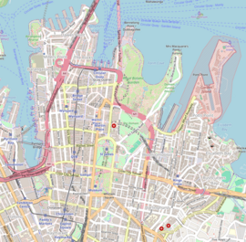
1972:Jeffrey Street
1969:
1964:
1959:
1954:
1949:
1947:Heathcote Road
1944:
1939:
1934:
1929:
1924:
1919:
1917:Darling Street
1914:
1909:
1907:City West Link
1904:
1899:
1894:
1892:Blacktown Road
1889:
1884:
1879:
1874:
1868:
1866:
1865:Suburban roads
1862:
1861:
1859:
1858:
1853:
1851:William Street
1848:
1846:Whitlam Square
1843:
1838:
1833:
1831:Stanley Street
1828:
1823:
1821:Queen's Square
1818:
1813:
1811:Phillip Street
1808:
1803:
1798:
1793:
1788:
1783:
1778:
1773:
1768:
1763:
1758:
1753:
1748:
1743:
1738:
1733:
1728:
1723:
1718:
1713:
1711:College Street
1708:
1703:
1698:
1693:
1688:
1683:
1678:
1676:Bayswater Road
1673:
1668:
1663:
1658:
1652:
1650:
1648:City of Sydney
1644:
1643:
1632:
1630:
1629:
1622:
1615:
1607:
1601:
1600:
1594:
1575:
1572:
1558:
1557:External links
1555:
1552:
1551:
1522:
1500:
1471:
1456:
1431:
1401:
1378:
1356:
1314:
1301:
1275:
1249:
1217:
1195:
1168:
1135:
1103:
1090:City of Sydney
1066:
1065:
1063:
1060:
1046:
1043:
1042:
1041:
1035:Bayswater Road
1024:
1017:
1015:
1012:
1005:
1003:
997:
990:
988:
985:
978:
974:
971:
968:
967:
965:
964:
952:
941:
929:
926:
925:
922:
900:Bayswater Road
896:
895:
893:
882:
879:
875:
874:
872:
860:
859:
856:
847:
844:
841:
830:
829:
823:
786:
783:
780:
769:
768:
763:
761:Sydney Airport
730:
727:
723:
722:
719:
695:
692:
688:
687:
684:
671:
668:
665:
654:
653:
651:
637:College Street
633:
632:
629:
620:
617:
614:
603:
602:
599:
596:
593:
590:
578:City of Sydney
573:
570:
443:William Street
419:
416:
368:Bayswater Road
343:
340:
316:William Street
311:
310:
301:Bayswater Road
291:
287:
286:
285:
284:
277:
276:
271:
266:
264:College Street
260:
258:
254:
253:
240:
236:
235:
231:
230:
219:
213:
212:
209:
203:
202:
199:
195:
194:
191:
187:
186:
183:
179:
178:
174:
173:
172:
171:
138:
103:
97:
96:
87:
86:
79:
78:
73:
72:
65:
64:
58:
57:
56:
55:
52:
51:
43:
42:
34:
33:
28:
25:William Street
24:
15:
13:
10:
9:
6:
4:
3:
2:
2115:
2104:
2101:
2099:
2096:
2094:
2091:
2090:
2088:
2073:
2072:Wolseley Road
2070:
2068:
2065:
2063:
2062:Victoria Road
2060:
2058:
2055:
2053:
2050:
2048:
2045:
2043:
2040:
2038:
2037:Richmond Road
2035:
2033:
2030:
2028:
2025:
2023:
2020:
2018:
2015:
2013:
2010:
2008:
2005:
2003:
2000:
1998:
1997:Norton Street
1995:
1993:
1990:
1988:
1985:
1983:
1980:
1978:
1975:
1973:
1970:
1968:
1965:
1963:
1960:
1958:
1955:
1953:
1950:
1948:
1945:
1943:
1940:
1938:
1935:
1933:
1930:
1928:
1925:
1923:
1920:
1918:
1915:
1913:
1910:
1908:
1905:
1903:
1900:
1898:
1895:
1893:
1890:
1888:
1885:
1883:
1882:Bangor Bypass
1880:
1878:
1875:
1873:
1870:
1869:
1867:
1863:
1857:
1854:
1852:
1849:
1847:
1844:
1842:
1839:
1837:
1836:Sussex Street
1834:
1832:
1829:
1827:
1824:
1822:
1819:
1817:
1814:
1812:
1809:
1807:
1804:
1802:
1801:Oxford Street
1799:
1797:
1794:
1792:
1791:Market Street
1789:
1787:
1784:
1782:
1779:
1777:
1774:
1772:
1769:
1767:
1764:
1762:
1761:Hunter Street
1759:
1757:
1754:
1752:
1751:Harris Street
1749:
1747:
1744:
1742:
1739:
1737:
1734:
1732:
1731:George Street
1729:
1727:
1724:
1722:
1719:
1717:
1714:
1712:
1709:
1707:
1704:
1702:
1699:
1697:
1694:
1692:
1689:
1687:
1684:
1682:
1679:
1677:
1674:
1672:
1671:Bridge Street
1669:
1667:
1664:
1662:
1661:Alfred Street
1659:
1657:
1656:Albion Street
1654:
1653:
1651:
1649:
1645:
1640:
1636:
1628:
1623:
1621:
1616:
1614:
1609:
1608:
1605:
1597:
1591:
1587:
1583:
1578:
1577:
1573:
1571:
1569:
1564:
1556:
1536:
1532:
1526:
1523:
1519:
1515:
1512:
1511:
1504:
1501:
1488:
1481:
1475:
1472:
1468:
1467:
1460:
1457:
1445:
1441:
1435:
1432:
1419:
1415:
1411:
1405:
1402:
1398:
1394:
1391:
1390:
1382:
1379:
1375:
1371:
1368:
1367:
1360:
1357:
1354:
1352:
1348:
1343:
1329:
1325:
1318:
1315:
1311:
1305:
1302:
1289:
1285:
1279:
1276:
1263:
1259:
1253:
1250:
1237:
1233:
1232:
1227:
1221:
1218:
1205:
1199:
1196:
1183:
1179:
1172:
1169:
1156:
1152:
1148:
1142:
1140:
1136:
1124:
1123:
1118:
1112:
1110:
1108:
1104:
1091:
1085:
1080:
1074:
1072:
1068:
1061:
1059:
1058:
1053:
1044:
1039:
1036:
1032:
1028:
1021:
1016:
1009:
1004:
1001:
994:
989:
982:
977:
972:
961:
953:
950:
942:
939:
931:
930:
927:
921:
917:
913:
909:
905:
901:
897:
892:
887:
876:
871:
866:
861:
855:
851:
839:
835:
831:
828:
822:
817:
812:
808:
804:
795:
791:
778:
774:
770:
762:
758:
754:
739:
735:
734:Woolloomooloo
724:
718:
714:
704:
700:
699:Woolloomooloo
689:
683:
679:
678:Woolloomooloo
675:
663:
659:
658:Woolloomooloo
655:
650:
646:
642:
638:
634:
628:
624:
612:
608:
604:
587:
584:
582:
579:
571:
569:
567:
562:
560:
555:
553:
549:
548:Taylor Square
545:
541:
537:
532:
530:
526:
522:
518:
514:
510:
506:
501:
499:
494:
490:
486:
482:
478:
474:
473:William House
470:
466:
461:
459:
455:
451:
446:
444:
440:
435:
433:
429:
428:Elizabeth Bay
425:
417:
415:
413:
410:
407:
402:
400:
396:
392:
387:
385:
381:
380:Woolloomooloo
377:
373:
369:
365:
361:
357:
353:
349:
341:
339:
337:
333:
329:
325:
321:
317:
308:
303:
302:
297:
296:
292:
288:
283:
280:
279:
275:
272:
270:
267:
265:
262:
261:
259:
255:
251:
246:
245:
241:
237:
232:
220:
214:
211:December 1964
210:
208:
204:
200:
196:
192:
188:
184:
180:
175:
167:
139:
134:
106:
105:
104:
102:
98:
62:
53:
49:
44:
40:
35:
31:
22:
19:
2067:Windsor Road
1962:Hume Highway
1872:Anzac Parade
1850:
1796:Martin Place
1716:Crown Street
1581:
1560:
1542:. Retrieved
1525:
1509:
1503:
1491:. Retrieved
1486:
1474:
1464:
1459:
1447:. Retrieved
1443:
1434:
1422:. Retrieved
1413:
1404:
1399:8 April 1929
1387:
1381:
1365:
1359:
1351:CC BY 3.0 AU
1339:
1331:. Retrieved
1327:
1322:Dunn, Mark.
1317:
1309:
1304:
1292:. Retrieved
1287:
1278:
1266:. Retrieved
1261:
1252:
1240:. Retrieved
1229:
1220:
1208:. Retrieved
1198:
1186:. Retrieved
1181:
1171:
1159:. Retrieved
1150:
1126:. Retrieved
1120:
1094:. Retrieved
1048:
1027:Sydney Tower
957:
946:
935:
891:Darlinghurst
870:Darlinghurst
852: –
834:Darlinghurst
821:Darlinghurst
807:Darlinghurst
794:Darlinghurst
773:Darlinghurst
738:Darlinghurst
717:North Sydney
676: –
674:Crown Street
662:Darlinghurst
611:Darlinghurst
598:Destinations
575:
563:
558:
556:
533:
529:Crown Street
516:
507:through the
504:
502:
469:World War II
462:
458:Tilly Devine
453:
447:
439:Henry Lawson
436:
421:
409:road running
403:
388:
384:Darlinghurst
345:
320:thoroughfare
315:
314:
299:
293:
269:Crown Street
242:
218:route number
18:
1982:King Street
1922:Epping Road
1856:York Street
1826:Rowe Street
1816:Pitt Street
1806:Park Street
1776:Lime Street
1771:King Street
1766:Kent Street
1721:Eddy Avenue
1641:, Australia
1633:Streets of
1182:Dick's blog
1122:Google Maps
920:Watsons Bay
904:Kings Cross
865:Kings Cross
816:Kings Cross
790:Kings Cross
777:Potts Point
703:Potts Point
682:Surry Hills
623:Park Street
465:World War I
424:Potts Point
244:Park Street
228:(1976–2004)
161: /
149:151°13′38″E
128: /
116:151°12′45″E
101:Coordinates
2087:Categories
1897:Bondi Road
1877:Appian Way
1756:Hay Street
1595:0959670254
1586:Paddington
1389:therewith.
1333:12 January
1268:12 January
1210:12 January
1188:12 January
1128:11 January
1096:12 January
1062:References
962:transition
912:Double Bay
641:Sydney CBD
627:Sydney CBD
607:Sydney CBD
336:William IV
250:Sydney CBD
146:33°52′36″S
113:33°52′25″S
2042:Ryde Road
1696:City Road
1493:24 August
1449:24 August
1294:22 August
1029:with the
854:Haymarket
645:Haymarket
406:City2Surf
356:Hyde Park
332:Australia
1681:Broadway
1544:1 August
1514:Archived
1418:Archived
1393:Archived
1370:Archived
1353:licence.
1236:Archived
1155:Archived
1084:MS Excel
1045:See also
916:Vaucluse
840:boundary
779:boundary
664:boundary
613:boundary
589:Location
546:towards
485:Chrysler
481:Plymouth
290:East end
239:West end
207:Gazetted
88:East end
74:West end
1444:Ozroads
1242:7 April
1119:(Map).
973:Gallery
649:Redfern
418:History
412:fun run
358:in the
50:in 2008
1635:Sydney
1592:
1424:31 May
1161:31 May
949:Tolled
757:Botany
491:. The
324:Sydney
257:
216:Former
198:Opened
190:Length
185:Street
1538:(PDF)
1483:(PDF)
960:Route
601:Notes
342:Route
1590:ISBN
1546:2022
1495:2021
1451:2021
1426:2023
1347:text
1335:2017
1296:2007
1270:2017
1244:2021
1212:2017
1190:2017
1163:2023
1130:2017
1098:2017
881:0.87
846:0.81
785:0.56
729:0.31
694:0.25
670:0.19
534:The
483:and
467:and
450:pubs
393:, a
389:The
382:and
370:and
350:and
348:Park
201:1834
182:Type
878:1.4
843:1.3
782:0.9
741:to
726:0.5
706:to
691:0.4
667:0.3
619:0.0
616:0.0
374:in
322:in
2089::
1637:,
1584:.
1485:.
1442:.
1412:.
1326:.
1286:.
1260:.
1234:.
1228:.
1180:.
1149:.
1138:^
1106:^
1088:.
1070:^
918:,
914:,
809:,
792:,
759:,
736:,
701:,
680:,
647:,
643:,
639:–
625:–
595:mi
592:km
583:.
554:.
500:.
460:.
330:,
326:,
1626:e
1619:t
1612:v
1598:.
1548:.
1497:.
1453:.
1428:.
1337:.
1298:.
1272:.
1246:.
1214:.
1192:.
1165:.
1132:.
1100:.
1082:(
836:–
775:–
660:–
609:–
Text is available under the Creative Commons Attribution-ShareAlike License. Additional terms may apply.