1435:
52:
270:. The signal box was to the south and to the east was a goods shed with four sidings and a loading bank. Passenger numbers started to decline in the 1920s when bus services were introduced. This led to the station closing on 21 September 1953. It remained open to goods until 2 August 1960. The station itself was demolished but the signal box remained until 1982. After it was demolished, the signal box from
286:
On 9 December 1964, twenty three coal wagons uncoupled from a shunter and ran down the line until colliding with another goods train. This resulted in one death and the line being blocked for several days. Sixty men had to work on cleaning up the debris while the trains were diverted via
1476:
1510:
1505:
1091:
436:
1500:
1495:
1525:
1469:
872:
429:
88:
1520:
1462:
900:
1280:
663:
169:
1515:
1232:
454:
422:
267:
151:
141:
1376:
1247:
933:
915:
774:
739:
1151:
802:
1029:
701:
706:
1348:
1353:
1004:
890:
696:
513:
164:
1284:
1146:
1048:
1034:
943:
624:
543:
792:
1338:
1312:
1307:
1237:
1168:
1061:
1009:
882:
834:
769:
658:
619:
549:
477:
849:
584:
1434:
1332:
1227:
1162:
839:
574:
467:
1014:
1358:
1317:
1270:
1178:
938:
826:
822:
630:
594:
554:
403:
599:
1391:
1343:
1199:
1141:
1136:
1076:
1044:
681:
538:
518:
462:
734:
1401:
1386:
1302:
1255:
1204:
1188:
1183:
1173:
1157:
1131:
961:
895:
867:
807:
784:
759:
754:
711:
653:
614:
487:
389:
367:
288:
251:
1414:
1409:
1381:
1222:
1126:
1071:
1019:
986:
971:
928:
797:
764:
691:
640:
497:
482:
472:
394:
271:
255:
528:
1327:
1265:
1097:
1066:
981:
976:
966:
749:
744:
729:
686:
648:
533:
508:
51:
1081:
1297:
1260:
1194:
1056:
905:
859:
844:
812:
609:
523:
1121:
1024:
604:
589:
564:
377:
239:
70:
22:
1322:
1292:
923:
1086:
953:
1368:
1214:
721:
1442:
247:
996:
313:
1446:
1107:
414:
275:
30:
26:
1489:
673:
446:
243:
74:
334:
21:
This article is about the former public railway station serving the village of
317:
103:
90:
310:
Railway passenger stations in
England, Scotland and Wales - a chronology
418:
312:. Richmond: Railway and Canal Historical Society. p. 69.
1450:
329:
327:
1400:
1367:
1279:
1246:
1213:
1106:
1043:
995:
952:
914:
881:
858:
821:
783:
720:
672:
639:
573:
496:
453:
206:
198:
183:
178:
157:
147:
137:
132:
124:
119:
82:
66:
61:
38:
250:, from 1894 to 1953. The station was built by the
238:was a railway station which served the village of
254:on the Beamish Deviation Line off of the earlier
16:Disused railway station in Beamish, County Durham
1511:Railway stations in Great Britain closed in 1953
1506:Railway stations in Great Britain opened in 1894
25:. For the recreated railway station exhibit at
1470:
430:
339:A History of the Tyne Dock To Consett Railway
266:The station opened on 1 February 1894 by the
8:
274:was dismantled and installed at the nearby
1501:Former North Eastern Railway (UK) stations
1477:
1463:
437:
423:
415:
50:
35:
1496:Disused railway stations in County Durham
1281:South Durham and Lancashire Union Railway
1526:North East England railway station stubs
360:
300:
1441:This article on a railway station in
1248:Darlington and Barnard Castle Railway
31:Beamish Museum § Railway station
7:
1431:
1429:
1115:Byers Green Branch and NER Extension
916:Bishop Auckland and Weardale Railway
501:NER Annfield and Beamish Deviations
1449:. You can help Knowledge (XXG) by
14:
1521:1960 disestablishments in England
1433:
823:Great North of England, Clarence
170:British Railways (North Eastern)
165:London and North Eastern Railway
1285:Stockton and Darlington Railway
1049:Stockton and Hartlepool Railway
827:and Hartlepool Junction Railway
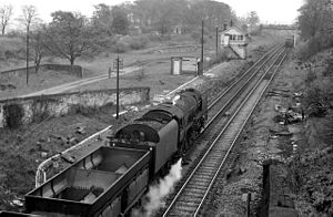
56:The site of the station in 1965
1516:1894 establishments in England
883:Durham to Bishop Auckland Line
1:
575:Durham and Sunderland Railway
1045:Hartlepool Dock and Railway
901:Willington (County Durham)
873:Waterhouses (County Durham)
445:Closed railway stations in
1542:
1428:
785:Weardale Extension Railway
20:
664:Aldin Grange for Bearpark
641:Lanchester Valley Railway
498:Stanhope and Tyne Railway
402:
395:Stanhope and Tyne Railway
388:
376:
366:
256:Stanhope and Tyne Railway
229:
225:
221:
184:1 February 1894
49:
793:Crawley (Northumberland)
1233:Wynyard (County Durham)
860:Deerness Valley Railway
408:Line and station closed
382:Line and station closed
207:2 August 1960
585:Seaton (County Durham)
455:Derwent Valley Railway
23:Beamish, County Durham
1377:Middleton-in-Teesdale
1092:Hartlepool (HD&R)
390:North Eastern Railway
268:North Eastern Railway
252:North Eastern Railway
152:North Eastern Railway
142:North Eastern Railway
1113:Port Clarence Branch
954:East Coast Main Line
934:Wear Valley Junction
775:Wear Valley Junction
740:Westgate-in-Weardale
202:Closed to passengers
1369:Tees Valley Railway
1215:Castle Eden Railway
1152:Stockton (Clarence)
1015:Hawthorn Tower Halt
803:Saltersgate Cottage
722:Wear Valley Railway
368:Historical railways
308:Quick, M E (2002).
100: /
62:General information
1443:North East England
1402:Tanfield Waggonway
1349:Stockton (S&D)
1174:Billingham-on-Tees
1030:Blackhall Colliery
702:Durham (Gilesgate)
600:Haswell (D&S)
372:Following station
364:Preceding station
248:North East England
104:54.8769°N 1.6526°W
1458:
1457:
1423:
1422:
1354:Newport (S&D)
1111:Simpasture Branch
997:Durham Coast Line
707:Sherburn Colliery
413:
412:
233:
232:
199:21 September 1953
120:Other information
1533:
1479:
1472:
1465:
1437:
1430:
1108:Clarence Railway
1005:Seaham Hall Dene
891:Brandon Colliery
697:Belmont (Durham)
578:NER Elvet Branch
539:Pelton (S&T)
439:
432:
425:
416:
409:
397:
383:
361:
350:
349:
347:
345:
331:
322:
321:
305:
214:
212:
191:
189:
138:Original company
115:
114:
112:
111:
110:
109:54.8769; -1.6526
105:
101:
98:
97:
96:
93:
54:
36:
1541:
1540:
1536:
1535:
1534:
1532:
1531:
1530:
1486:
1485:
1484:
1483:
1426:
1424:
1419:
1396:
1363:
1337:
1283:
1275:
1242:
1209:
1193:
1167:
1156:
1147:Norton Junction
1114:
1112:
1110:
1102:
1096:
1047:
1039:
1035:Blackhall Rocks
991:
948:
944:Tunnel Junction
910:
877:
854:
825:
817:
779:
735:St Johns Chapel
716:
668:
635:
629:
625:Shincliffe Town
577:
569:
548:
544:Durham Turnpike
502:
500:
492:
449:
443:
407:
406:
393:
392:
381:
380:
359:
354:
353:
343:
341:
333:
332:
325:
307:
306:
302:
297:
284:
264:
217:Closed to goods
210:
208:
187:
185:
174:
108:
106:
102:
99:
94:
91:
89:
87:
86:
77:
57:
45:
44:
43:
34:
17:
12:
11:
5:
1539:
1537:
1529:
1528:
1523:
1518:
1513:
1508:
1503:
1498:
1488:
1487:
1482:
1481:
1474:
1467:
1459:
1456:
1455:
1438:
1421:
1420:
1418:
1417:
1412:
1406:
1404:
1398:
1397:
1395:
1394:
1389:
1384:
1379:
1373:
1371:
1365:
1364:
1362:
1361:
1359:Watson's Wharf
1356:
1351:
1346:
1341:
1339:Fighting Cocks
1335:
1330:
1325:
1320:
1315:
1313:Cockfield Fell
1310:
1308:Barnard Castle
1305:
1300:
1295:
1289:
1287:
1277:
1276:
1274:
1273:
1268:
1263:
1258:
1252:
1250:
1244:
1243:
1241:
1240:
1238:Thorpe Thewles
1235:
1230:
1225:
1219:
1217:
1211:
1210:
1208:
1207:
1202:
1197:
1191:
1186:
1181:
1176:
1171:
1169:Norton-on-Tees
1165:
1160:
1154:
1149:
1144:
1139:
1134:
1129:
1124:
1118:
1116:
1104:
1103:
1101:
1100:
1094:
1089:
1084:
1079:
1074:
1069:
1064:
1062:Shotton Bridge
1059:
1053:
1051:
1041:
1040:
1038:
1037:
1032:
1027:
1025:Horden (first)
1022:
1017:
1012:
1010:Seaham Harbour
1007:
1001:
999:
993:
992:
990:
989:
984:
979:
974:
969:
964:
958:
956:
950:
949:
947:
946:
941:
936:
931:
926:
920:
918:
912:
911:
909:
908:
903:
898:
893:
887:
885:
879:
878:
876:
875:
870:
864:
862:
856:
855:
853:
852:
847:
842:
837:
835:West Cornforth
831:
829:
819:
818:
816:
815:
810:
805:
800:
795:
789:
787:
781:
780:
778:
777:
772:
770:Witton-le-Wear
767:
762:
757:
752:
747:
742:
737:
732:
726:
724:
718:
717:
715:
714:
709:
704:
699:
694:
689:
684:
678:
676:
670:
669:
667:
666:
661:
659:Witton Gilbert
656:
651:
645:
643:
637:
636:
634:
633:
627:
622:
620:Sherburn House
617:
612:
607:
602:
597:
592:
587:
581:
579:
571:
570:
568:
567:
562:
557:
552:
550:Annfield Plain
546:
541:
536:
531:
526:
521:
516:
511:
505:
503:
494:
493:
491:
490:
488:Consett (DVR)
485:
480:
478:Shotley Bridge
475:
470:
465:
459:
457:
451:
450:
444:
442:
441:
434:
427:
419:
411:
410:
401:
398:
387:
384:
374:
373:
370:
365:
358:
357:External links
355:
352:
351:
323:
299:
298:
296:
293:
283:
280:
276:Beamish Museum
263:
260:
231:
230:
227:
226:
223:
222:
219:
218:
215:
204:
203:
200:
196:
195:
192:
181:
180:
176:
175:
173:
172:
167:
161:
159:
155:
154:
149:
145:
144:
139:
135:
134:
130:
129:
126:
122:
121:
117:
116:
84:
80:
79:
68:
64:
63:
59:
58:
55:
47:
46:
41:
40:
39:
27:Beamish Museum
15:
13:
10:
9:
6:
4:
3:
2:
1538:
1527:
1524:
1522:
1519:
1517:
1514:
1512:
1509:
1507:
1504:
1502:
1499:
1497:
1494:
1493:
1491:
1480:
1475:
1473:
1468:
1466:
1461:
1460:
1454:
1452:
1448:
1444:
1439:
1436:
1432:
1427:
1416:
1413:
1411:
1408:
1407:
1405:
1403:
1399:
1393:
1390:
1388:
1385:
1383:
1380:
1378:
1375:
1374:
1372:
1370:
1366:
1360:
1357:
1355:
1352:
1350:
1347:
1345:
1342:
1340:
1336:
1334:
1333:West Auckland
1331:
1329:
1326:
1324:
1321:
1319:
1316:
1314:
1311:
1309:
1306:
1304:
1301:
1299:
1296:
1294:
1291:
1290:
1288:
1286:
1282:
1278:
1272:
1269:
1267:
1264:
1262:
1259:
1257:
1254:
1253:
1251:
1249:
1245:
1239:
1236:
1234:
1231:
1229:
1228:Hurworth Burn
1226:
1224:
1221:
1220:
1218:
1216:
1212:
1206:
1203:
1201:
1198:
1196:
1192:
1190:
1189:Port Clarence
1187:
1185:
1184:Haverton Hill
1182:
1180:
1177:
1175:
1172:
1170:
1166:
1164:
1163:Demons Bridge
1161:
1159:
1155:
1153:
1150:
1148:
1145:
1143:
1140:
1138:
1135:
1133:
1130:
1128:
1125:
1123:
1122:Coxhoe (WHHR)
1120:
1119:
1117:
1109:
1105:
1099:
1095:
1093:
1090:
1088:
1085:
1083:
1080:
1078:
1075:
1073:
1070:
1068:
1065:
1063:
1060:
1058:
1055:
1054:
1052:
1050:
1046:
1042:
1036:
1033:
1031:
1028:
1026:
1023:
1021:
1018:
1016:
1013:
1011:
1008:
1006:
1003:
1002:
1000:
998:
994:
988:
985:
983:
980:
978:
975:
973:
970:
968:
965:
963:
960:
959:
957:
955:
951:
945:
942:
940:
937:
935:
932:
930:
927:
925:
922:
921:
919:
917:
913:
907:
904:
902:
899:
897:
894:
892:
889:
888:
886:
884:
880:
874:
871:
869:
866:
865:
863:
861:
857:
851:
848:
846:
843:
841:
840:Coxhoe Bridge
838:
836:
833:
832:
830:
828:
824:
820:
814:
811:
809:
806:
804:
801:
799:
796:
794:
791:
790:
788:
786:
782:
776:
773:
771:
768:
766:
763:
761:
758:
756:
753:
751:
748:
746:
743:
741:
738:
736:
733:
731:
728:
727:
725:
723:
719:
713:
710:
708:
705:
703:
700:
698:
695:
693:
690:
688:
685:
683:
680:
679:
677:
675:
674:Leamside line
671:
665:
662:
660:
657:
655:
652:
650:
647:
646:
644:
642:
638:
632:
628:
626:
623:
621:
618:
616:
613:
611:
608:
606:
603:
601:
598:
596:
593:
591:
588:
586:
583:
582:
580:
576:
572:
566:
563:
561:
558:
556:
553:
551:
547:
545:
542:
540:
537:
535:
532:
530:
527:
525:
522:
520:
517:
515:
512:
510:
507:
506:
504:
499:
495:
489:
486:
484:
481:
479:
476:
474:
471:
469:
468:High Westwood
466:
464:
461:
460:
458:
456:
452:
448:
447:County Durham
440:
435:
433:
428:
426:
421:
420:
417:
405:
399:
396:
391:
385:
379:
375:
371:
369:
363:
362:
356:
340:
336:
330:
328:
324:
319:
315:
311:
304:
301:
294:
292:
290:
281:
279:
277:
273:
269:
261:
259:
257:
253:
249:
245:
244:County Durham
241:
237:
228:
224:
220:
216:
205:
201:
197:
193:
182:
177:
171:
168:
166:
163:
162:
160:
158:Post-grouping
156:
153:
150:
146:
143:
140:
136:
131:
127:
123:
118:
113:
85:
81:
76:
75:County Durham
72:
69:
65:
60:
53:
48:
37:
32:
28:
24:
19:
1451:expanding it
1440:
1425:
1415:Bowes Bridge
1410:Tanfield Lea
1318:Haggerleases
1271:Piercebridge
1179:Belasis Lane
939:South Church
631:Durham Elvet
595:South Hetton
559:
555:West Stanley
404:West Stanley
342:. Retrieved
338:
309:
303:
285:
265:
235:
234:
148:Pre-grouping
18:
1392:Cotherstone
1344:Yarm Depots
1200:Byers Green
1142:Redmarshall
1137:Stillington
1077:Castle Eden
682:Fencehouses
519:Hownes Gill
463:Lintz Green
107: /
83:Coordinates
1490:Categories
1387:Romaldkirk
1303:Lartington
1256:Broomielaw
1205:Spennymoor
1158:Simpasture
1132:Sedgefield
962:Plawsworth
896:Brancepeth
868:Ushaw Moor
808:High Stoop
760:Wolsingham
755:Frosterley
712:Shincliffe
654:Lanchester
615:Pittington
529:Carr House
295:References
289:Lanchester
211:1960-08-02
188:1894-02-01
92:54°52′37″N
1382:Mickleton
1223:Wellfield
1127:Ferryhill
1072:Wellfield
1020:Easington
987:Croft Spa
972:Ferryhill
929:Beechburn
798:Waskerley
765:Harperley
692:Frankland
483:Blackhill
473:Ebchester
344:7 January
335:"Beamish"
318:931112387
272:Carrhouse
179:Key dates
95:1°39′09″W
1328:Evenwood
1266:Gainford
1098:Greatham
1082:Hesleden
1067:Thornley
982:Aycliffe
977:Bradbury
967:Croxdale
750:Stanhope
745:Eastgate
730:Wearhead
687:Leamside
649:Knitsley
534:Leadgate
509:Burnhill
282:Accident
67:Location
1298:Hulands
1261:Winston
1195:Coundon
1057:Haswell
906:Hunwick
850:Wingate
845:Trimdon
813:Tow Law
610:Rainton
560:Beamish
524:Consett
400:
386:
262:History
240:Beamish
236:Beamish
209: (
186: (
133:History
128:Disused
78:England
71:Beamish
42:Beamish
605:Hetton
590:Murton
565:Pelton
514:Rowley
378:Pelton
316:
194:Opened
125:Status
29:, see
1445:is a
1323:Lands
1293:Bowes
924:Crook
1447:stub
1087:Hart
346:2021
314:OCLC
242:in
1492::
337:.
326:^
291:.
278:.
258:.
246:,
73:,
1478:e
1471:t
1464:v
1453:.
438:e
431:t
424:v
348:.
320:.
213:)
190:)
33:.
Text is available under the Creative Commons Attribution-ShareAlike License. Additional terms may apply.