188:
East and West branches, and five smaller tributaries. The West Branch is now also called the
Franklin River. The East Branch lies almost entirely within Annapolis County. The East Branch was once well known as a salmon river. One of the lakes in the watershed, now called Charlotte Lake, was at one time known as Salmon Lake. The East Branch flows out of a granite upland plateau about 7.2 kilometres (4.5 mi) south east of Mulgrave Lake, (formerly Big Lake and East Bear River Lake). The East Branch flows about 21.7 kilometres (13.5 mi) to its confluence with the West Branch. Beginning around 1950, hydroelectric power has been produced by impounding water in the upper watershed. Mulgrave Lake has been dammed and two additional dams now form head ponds for the Gulch Power Station in Bear River. Franklin River (Bear River West Branch) has its source at Lake Franklin located about 16 kilometres (9.9 mi) southeast of the village. The 4 kilometres (2.5 mi) long Lake Jolly is situated along the river course.
164:
356:
36:
187:
The river is fed by several streams but even so, at low tide the mud flats, grasses and reeds are very visible. However, at high tide, the salt water from the basin flows in and fills the river to a height of up to 26 feet. There are two main tributaries which converge at the tide head, known as the
171:
The river forms part of the boundary between
Annapolis and Digby Counties. The steep forested slopes and natural environment, particularly in the lower reaches, have led to the nickname "The Switzerland of Nova Scotia" being applied to the river valley area. The deeply cut valley, hewn from the
200:
at the mouth of the river (which drains into the
Annapolis Basin), approximately 6 km from the community. The second is located in downtown Bear River and connects the two halves of the village together. There are several shorter bridges further inland.
196:
In addition to the railway bridge, built in 1912 and demolished in late 2011, there are two primary highway bridges which span the Bear River. The longest is the Bear River Bridge located on
152:
at the start of the seventeenth century. Samuel de
Champlain called it Rivière St. Antoine (St. Anthony's River) on his first map, but the name did not survive. In 1609 it appeared as
329:, Nova Scotia Museum. As the river is forty kilometers long today and Digby Gut lies about 6 kilometers across the Annapolis Basin, the river was effectively shortened by 15 percent.
921:
926:
428:
125:
is a minor river in western Nova Scotia, Canada. Flowing from south to north, it is 40 kilometres (25 mi) long from its headwaters to its discharge into the
377:
648:
301:
234:
137:(which today calls itself "The Tidal Village") is situated near the head of the tide where shipbuilding took place in the nineteenth century.
855:
160:) on Lescarbot's map and the name held. It was altered following English occupation of the region probably in the late eighteenth century.
421:
61:
149:
509:
359:
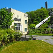
Bear River passes under Nova Scotia
Highway 101 and an abandoned railway bridge as it discharges into the Annapolis Basin (right).
322:
441:
931:
414:
369:
865:
437:
210:
253:
342:
782:
481:
697:
653:
606:
542:
537:
630:
850:
841:
514:
499:
489:
197:
141:
134:
17:
757:
735:
466:
744:
140:
The river lies within an area long-occupied by native Mi'kmaq people, embodied today by members of the
752:
524:
173:
298:
229:
611:
504:
130:
808:
133:. The river is tidal for the last 9.7 kilometres (6.0 mi) of its length. The community of
547:
886:
860:
674:
406:
281:
896:
616:
583:
575:
552:
494:
471:
346:
326:
305:
257:
238:
126:
93:
157:
891:
813:
705:
449:
317:
163:
915:
803:
777:
762:
688:
458:
881:
818:
772:
721:
658:
639:
598:
566:
532:
181:
832:
355:
148:, (pronounced "elsetkook"). The area was settled by European settlers at nearby
78:
66:
35:
798:
767:
250:
392:
379:
340:"A Good Place to Grow Up (Or A River Runs Through It – Nova Scotia Version)"
177:
105:
339:
172:
contact between slate bedrock on the west and granite on the east, is a
54:
354:
162:
144:
who still reside on the river. The native name for the river is
410:
268:
299:
Bear River First Nation
Heritage and Cultural Centre
874:
840:
831:
791:
743:
734:
714:
696:
687:
667:
638:
629:
597:
574:
565:
523:
480:
457:
448:
111:
99:
87:
77:
72:
60:
50:
45:
28:
422:
316:Natural History of Nova Scotia Theme Region:
8:
922:Landforms of Annapolis County, Nova Scotia
837:
740:
693:
635:
571:
454:
429:
415:
407:
129:, some 6 kilometres (3.7 mi) east of
16:For the community named Bear River, see
222:
927:Landforms of Digby County, Nova Scotia
25:
286:Place-Names and Places of Nova Scotia
251:"The River: From the Land to the Sea"
7:
282:"Bear River" and "Bear River East"
14:
249:Bear River Millyard Recreation,
34:
370:Pictures of the railway bridge
1:
211:List of rivers of Nova Scotia
73:Physical characteristics
184:forms the northern extreme.
101: • elevation
23:River in Nova Scotia, Canada
89: • location
948:
15:
269:Bear River Board of Trade
33:
515:West River Sheet Harbour
490:East River Sheet Harbour
297:Travel and Transitions,
231:North American Gazetteer
150:habitation at Port Royal
237:April 26, 2005, at the
142:Bear River First Nation
115:40 km (25 mi)
40:Bear River, Nova Scotia
18:Bear River, Nova Scotia
758:Middle River of Pictou
736:Gulf of Saint Lawrence
467:Little Sackville River
360:
256:July 14, 2011, at the
168:
932:Rivers of Nova Scotia
745:Northumberland Strait
438:Rivers of Nova Scotia
358:
345:May 31, 2010, at the
288:, 1967, pp. 45 and 46
166:
753:East River of Pictou
280:C. Bruce Fergusson,
174:drowned river valley
389: /
167:Gulch Power Station
612:Shubenacadie River
505:Musquodoboit River
361:
325:2009-12-08 at the
304:2010-05-27 at the
169:
909:
908:
905:
904:
827:
826:
730:
729:
683:
682:
625:
624:
561:
560:
393:44.618°N 65.681°W
119:
118:
939:
887:Cornwallis River
861:Kennetcook River
838:
741:
694:
675:Missaguash River
636:
631:Cumberland Basin
572:
510:St. Mary's River
455:
431:
424:
417:
408:
404:
403:
401:
400:
399:
394:
390:
387:
386:
385:
382:
349:
336:
330:
319:720 Basalt Ridge
314:
308:
295:
289:
278:
272:
271:Official Website
266:
260:
247:
241:
227:
38:
26:
947:
946:
942:
941:
940:
938:
937:
936:
912:
911:
910:
901:
897:Gaspereau River
870:
866:St. Croix River
823:
809:Chéticamp River
787:
726:
710:
679:
663:
621:
617:Stewiacke River
593:
584:Annapolis River
576:Annapolis Basin
557:
553:Shelburne River
519:
495:Framboise River
476:
472:Sackville River
444:
442:drainage system
435:
398:44.618; -65.681
397:
395:
391:
388:
383:
380:
378:
376:
375:
366:
353:
352:
347:Wayback Machine
337:
333:
327:Wayback Machine
315:
311:
306:Wayback Machine
296:
292:
279:
275:
267:
263:
258:Wayback Machine
248:
244:
239:Wayback Machine
228:
224:
219:
207:
194:
127:Annapolis Basin
102:
94:Annapolis Basin
90:
41:
24:
21:
12:
11:
5:
945:
943:
935:
934:
929:
924:
914:
913:
907:
906:
903:
902:
900:
899:
894:
892:Farrells River
889:
884:
878:
876:
872:
871:
869:
868:
863:
858:
853:
847:
845:
835:
829:
828:
825:
824:
822:
821:
816:
814:Margaree River
811:
806:
801:
795:
793:
789:
788:
786:
785:
780:
775:
770:
765:
760:
755:
749:
747:
738:
732:
731:
728:
727:
725:
724:
718:
716:
712:
711:
709:
708:
706:Sissiboo River
702:
700:
691:
685:
684:
681:
680:
678:
677:
671:
669:
665:
664:
662:
661:
656:
651:
645:
643:
633:
627:
626:
623:
622:
620:
619:
614:
609:
603:
601:
595:
594:
592:
591:
586:
580:
578:
569:
563:
562:
559:
558:
556:
555:
550:
548:Petite Rivière
545:
540:
535:
529:
527:
521:
520:
518:
517:
512:
507:
502:
497:
492:
486:
484:
478:
477:
475:
474:
469:
463:
461:
452:
450:Atlantic Ocean
446:
445:
436:
434:
433:
426:
419:
411:
373:
372:
365:
364:External links
362:
351:
350:
331:
309:
290:
273:
261:
242:
221:
220:
218:
215:
214:
213:
206:
203:
193:
190:
156:(probably for
154:Rivière Hébert
117:
116:
113:
109:
108:
103:
100:
97:
96:
91:
88:
85:
84:
81:
75:
74:
70:
69:
64:
58:
57:
52:
48:
47:
43:
42:
39:
31:
30:
22:
13:
10:
9:
6:
4:
3:
2:
944:
933:
930:
928:
925:
923:
920:
919:
917:
898:
895:
893:
890:
888:
885:
883:
880:
879:
877:
873:
867:
864:
862:
859:
857:
856:Halfway River
854:
852:
849:
848:
846:
843:
839:
836:
834:
830:
820:
817:
815:
812:
810:
807:
805:
804:Baddeck River
802:
800:
797:
796:
794:
790:
784:
783:Wallace River
781:
779:
778:Tidnish River
776:
774:
771:
769:
766:
764:
763:Pugwash River
761:
759:
756:
754:
751:
750:
748:
746:
742:
739:
737:
733:
723:
720:
719:
717:
713:
707:
704:
703:
701:
699:
698:St. Marys Bay
695:
692:
690:
689:Gulf of Maine
686:
676:
673:
672:
670:
666:
660:
657:
655:
652:
650:
649:Halfway River
647:
646:
644:
641:
637:
634:
632:
628:
618:
615:
613:
610:
608:
605:
604:
602:
600:
596:
590:
587:
585:
582:
581:
579:
577:
573:
570:
568:
564:
554:
551:
549:
546:
544:
541:
539:
536:
534:
531:
530:
528:
526:
522:
516:
513:
511:
508:
506:
503:
501:
498:
496:
493:
491:
488:
487:
485:
483:
482:Eastern Shore
479:
473:
470:
468:
465:
464:
462:
460:
459:Bedford Basin
456:
453:
451:
447:
443:
439:
432:
427:
425:
420:
418:
413:
412:
409:
405:
402:
371:
368:
367:
363:
357:
348:
344:
341:
335:
332:
328:
324:
321:
320:
313:
310:
307:
303:
300:
294:
291:
287:
283:
277:
274:
270:
265:
262:
259:
255:
252:
246:
243:
240:
236:
233:
232:
226:
223:
216:
212:
209:
208:
204:
202:
199:
191:
189:
185:
183:
179:
175:
165:
161:
159:
155:
151:
147:
143:
138:
136:
132:
128:
124:
114:
110:
107:
104:
98:
95:
92:
86:
82:
80:
76:
71:
68:
65:
63:
59:
56:
53:
49:
44:
37:
32:
27:
19:
882:Canard River
819:Sydney River
773:River Philip
722:Tusket River
659:River Hebert
654:Maccan River
640:River Hebert
607:Salmon River
599:Cobequid Bay
588:
567:Bay of Fundy
543:Mersey River
538:Medway River
533:LaHave River
374:
334:
318:
312:
293:
285:
276:
264:
245:
230:
225:
195:
186:
182:Bay of Fundy
170:
158:Louis Hébert
153:
145:
139:
122:
120:
833:Minas Basin
525:South Shore
396: /
338:Ray Riley,
198:Highway 101
67:Nova Scotia
916:Categories
851:Avon River
842:Avon River
799:Aspy River
768:River John
589:Bear River
500:Mira River
384:65°40′52″W
381:44°37′05″N
217:References
135:Bear River
123:Bear River
29:Bear River
844:Watershed
642:Watershed
178:Digby Gut
176:of which
106:sea level
343:Archived
323:Archived
302:Archived
254:Archived
235:Archived
205:See also
146:L'sitkuk
62:Province
46:Location
192:Bridges
180:on the
51:Country
875:Others
792:Others
715:Others
668:Others
112:Length
83:
55:Canada
131:Digby
79:Mouth
121:The
440:by
918::
284:,
430:e
423:t
416:v
20:.
Text is available under the Creative Commons Attribution-ShareAlike License. Additional terms may apply.