564:
258:
1191:
1086:
871:
288:
318:
847:
859:
31:
835:
1198:
325:
295:
265:
460:
structure that was built by the
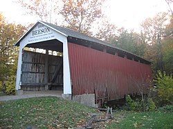
Frankfort Construction Company in 1906. The bridge is 55 feet (17 m) long, 16 feet (4.9 m) wide, with a clearance of 12 feet 6 inches (3.81 m). The bridge had concrete foundations when it was built and was placed on concrete foundations when it
540:
Less than a week later another fire was started just after midnight on August 15, 1979. A nearby neighbor saw someone at the bridge and heard a car turn around in his driveway. Shortly after that he saw flames at the bridge and contacted the Fire
Department. The Marshall Fire Department found the
477:
it was named after the nearby Beeson family. William H. Beeson, who was born in 1879, owned 53 acres of land near the bridge. It crossed
Roaring Creek on C.R. 216, which is now C.R. 200N. Using the map that Parke County sent when filing for NRHP status, the bridge was originally located at:
2082:
1454:
512:
The bridge was closed in 1969, because the abutments were declared unsafe. In March 1979, a nearby concrete bridge collapsed. This, along with the earlier closing of the Beeson
Covered Bridge, caused a severe problem with access to Marshall, and nearby
1984:
2036:
2041:
2077:
2001:
1954:
2046:
1934:
1894:
1624:
1604:
1224:
2006:
1996:
1979:
1959:
1654:
1629:
1609:
1569:
1484:
1384:
1991:
1909:
1819:
1424:
1404:
1369:
1234:
1944:
1939:
1809:
1599:
1554:
1464:
1444:
1429:
1409:
1364:
1354:
1329:
1324:
1299:
1284:
1274:
1128:
2051:
2011:
1904:
1879:
1674:
1649:
1594:
1584:
1544:
1449:
1439:
1414:
1389:
1359:
1314:
1309:
1289:
1279:
1269:
1249:
2031:
1969:
1949:
1924:
1914:
1899:
1889:
1874:
1854:
1824:
1814:
1804:
1644:
1639:
1614:
1589:
1579:
1559:
1549:
1534:
1509:
1494:
1489:
1479:
1469:
1459:
1394:
1379:
1349:
1339:
1334:
1304:
1294:
1229:
524:
At 11:47 pm on August 9, 1979, just shortly after the RCCA had a meeting at Turkey Run High School, a fire was reported at the Beeson Bridge. Firefighters from
Marshall, fought from the south end while firefighters from
2056:
2026:
1919:
1859:
1834:
1829:
1799:
1789:
1690:
1669:
1664:
1659:
1619:
1574:
1539:
1524:
1519:
1499:
1474:
1374:
1344:
1319:
1259:
1244:
1239:
1219:
1214:
1974:
1929:
1869:
1844:
1794:
1634:
1564:
1529:
1514:
1504:
1434:
1419:
1264:
1254:
2016:
1884:
1849:
1399:
2021:
1964:
1864:
1839:
2107:
537:
probably had jurisdiction too but declined to join. Due to the fire happening so close to the RCCA meeting the RCCA threatened legal action with anyone accusing them of being connected with the fire.
1121:
529:, fought from the north end of the bridge. The fire was found to be a clear case of arson, fuel oil odors were still strong the following morning. The Parke County Sheriff's Department,
1141:
1114:
257:
2097:
1718:
1713:
1180:
1170:
903:
563:
2102:
1695:
610:
317:
473:
Many of the bridges in Parke County are named after a nearby city or the body of water they cross but due to another bridge across the county being named the
875:
51:
287:
438:
481:
2112:
1723:
1165:
896:
235:
1761:
107:
1778:
1137:
1096:
684:
615:
226:
1085:
2092:
2087:
980:
889:
1040:
955:
132:
533:
and the
Indiana State Fire Marshal all were part of the investigation, owing that it is a registered national landmark the
1035:
930:
825:
544:
On
December 4, 1979, the Buchta Trucking Company began moving the bridge to its current location over Williams Creek, in
913:
605:
585:
44:
1070:
940:
935:
755:
1754:
1060:
970:
770:
1739:
1065:
1050:
1045:
1010:
995:
816:
787:
1075:
1055:
985:
945:
756:"National Register of Historic Places Inventory Nomination Form: Parke County Covered Bridge Historic District"
635:
1030:
990:
960:
590:
474:
1708:
1160:
1015:
1005:
975:
514:
1747:
1728:
1175:
1155:
1025:
965:
950:
689:
599:
594:
526:
518:
239:
1106:
1000:
809:
580:
545:
530:
442:
36:
1020:
680:"National Register Information System – Beeson Covered Bridge (#38) (#78003447)"
863:
549:
102:
434:
374:
851:
657:
846:
200:
839:
457:
858:
679:
400:
386:
30:
2071:
734:
2083:
Covered bridges on the
National Register of Historic Places in Parke County, Indiana
740:. Department of Natural Resources, Division of Historic Preservation and Archaeology
735:"Indiana State Historic Architectural and Archaeological Research Database (SHAARD)"
552:. They first removed the roof and sides before transporting the rest of the bridge.
521:. The Roaring Creek Citizens Association (RCCA) was formed to address this problem.
881:
150:
790:. Parke County Incorporated / Parke County Convention and Visitors Commission
496:
483:
66:
53:
454:
462:
122:
541:
bridge floor covered in flames but was quickly able to extinguish them.
433:
originally crossed
Roaring Creek, one mile (1.6 km) northwest of
2078:
Historic district contributing properties in USA Indiana Parke County
1774:
1770:
1743:
1110:
885:
534:
461:
was moved, but after a flood in 1989, the bridge was reset on
324:
294:
264:
2108:
Covered bridges in the United States destroyed by arson
717:
715:
713:
711:
709:
707:
823:
1714:
History of the
National Register of Historic Places
1683:
1205:
1171:
History of the National Register of Historic Places
1148:
418:
406:
393:
381:
369:
361:
346:
199:
188:
180:
172:
164:
156:
146:
141:
131:
121:
113:
98:
90:
82:
43:
21:
441:. The bridge was moved to its current location in
86:Pedestrian traffic (Not open to vehicular traffic)
2098:Relocated buildings and structures in Indiana
1755:
1122:
897:
611:List of Registered Historic Places in Indiana
569:Beeson Covered Bridge at Billie Creek Village
8:
453:The Beeson Covered Bridge is a single span
1762:
1748:
1740:
1129:
1115:
1107:
904:
890:
882:
18:
1138:U.S. National Register of Historic Places
721:
227:U.S. National Register of Historic Places
2103:Burr Truss bridges in the United States
830:
627:
559:
108:Adams Township, Parke County, Indiana
7:
1779:National Register of Historic Places
1097:Parke County Covered Bridge Festival
876:National Register of Historic Places
810:Parke County Covered Bridge Festival
685:National Register of Historic Places
616:Parke County Covered Bridge Festival
14:
754:Charles Felkner (December 1977).
439:Washington Township, Parke County
385:Parke County Covered Bridges TR (
331:Location of Beeson Covered Bridge
301:Location of Beeson Covered Bridge
277:Show map of Parke County, Indiana
271:Location of Beeson Covered Bridge
1196:
1189:
1084:
869:
857:
845:
833:
660:. Indiana Covered Bridge Society
562:
323:
316:
293:
286:
263:
256:
29:
773:, and Accompanying photographs.
531:Indiana State Police Department
16:Bridge in Parke County, Indiana
2113:1906 establishments in Indiana
602:, within Turkey Run State Park
395:
365:Frankfort Construction Company
189:
1:
788:"Beeson Covered Bridge (#38)"
337:Show map of the United States
914:Parke County Covered Bridges
606:Parke County Covered Bridges
586:Arch in the Town of Marshall
1696:National Historic Landmarks
219:Beeson Covered Bridge (#38)
2129:
2093:Wooden bridges in Indiana
2088:Bridges completed in 1906
1785:
1704:
1187:
1093:
1082:
921:
437:, on County Road 216, in
423:
414:
394:NRHP reference
250:
246:
233:
224:
217:
213:
209:
205:12.5 ft (3.8 m)
67:39.7632444°N 87.2064389°W
35:Beeson Covered Bridge in
28:
600:Richard Lieber Log Cabin
176:55 ft (16.8 m)
1455:Marion: Center Township
591:Lusk Home and Mill Site
497:39.859715°N 87.197165°W
475:Marshall Covered Bridge
184:16 ft (4.9 m)
72:39.7632444; -87.2064389
1709:Keeper of the Register
1161:Keeper of the Register
515:Turkey Run High School
236:U.S. Historic district
160:Concrete (foundations)
151:Burr arch truss bridge
1729:Contributing property
1176:National Park Service
1156:Contributing property
738:(Searchable database)
690:National Park Service
595:Turkey Run State Park
519:Turkey Run State Park
502:39.859715; -87.197165
431:Beeson Covered Bridge
240:Contributing property
23:Beeson Covered Bridge
581:Billie Creek Village
546:Billie Creek Village
443:Billie Creek Village
37:Billie Creek Village
981:Leatherwood Station
658:"The Beeson Bridge"
638:. Geo A. Ogle. 1908
636:"Parke County 1908"
493: /
307:Show map of Indiana
165:Trough construction
63: /
692:. January 23, 2007
445:in December 1979.
2065:
2064:
1737:
1736:
1724:Historic district
1166:Historic district
1104:
1103:
435:Marshall, Indiana
427:
426:
410:December 22, 1978
127:The Beeson Family
2120:
2042:Washington, D.C.
1764:
1757:
1750:
1741:
1200:
1199:
1193:
1192:
1131:
1124:
1117:
1108:
1088:
906:
899:
892:
883:
874:
873:
872:
862:
861:
850:
849:
838:
837:
836:
829:
820:
819:
817:Official website
799:
797:
795:
774:
768:
766:
765:
760:
748:
746:
745:
739:
731:
725:
719:
702:
701:
699:
697:
676:
670:
669:
667:
665:
654:
648:
647:
645:
643:
632:
566:
508:
507:
505:
504:
503:
498:
494:
491:
490:
489:
486:
397:
377:
357:
355:
338:
327:
326:
320:
308:
297:
296:
290:
278:
267:
266:
260:
191:
78:
77:
75:
74:
73:
68:
64:
61:
60:
59:
56:
33:
19:
2128:
2127:
2123:
2122:
2121:
2119:
2118:
2117:
2068:
2067:
2066:
2061:
1781:
1768:
1738:
1733:
1700:
1679:
1207:
1201:
1197:
1195:
1194:
1190:
1185:
1144:
1135:
1105:
1100:
1089:
1080:
917:
910:
880:
870:
868:
856:
844:
834:
832:
824:
815:
814:
806:
793:
791:
786:
783:
778:
777:
763:
761:
758:
753:
743:
741:
737:
733:
732:
728:
720:
705:
695:
693:
678:
677:
673:
663:
661:
656:
655:
651:
641:
639:
634:
633:
629:
624:
577:
570:
567:
558:
501:
499:
495:
492:
487:
484:
482:
480:
479:
471:
451:
373:
353:
351:
342:
341:
340:
339:
336:
335:
334:
333:
332:
328:
311:
310:
309:
306:
305:
304:
303:
302:
298:
281:
280:
279:
276:
275:
274:
273:
272:
268:
242:
238:
229:
220:
201:Clearance above
142:Characteristics
106:
94:William's Creek
71:
69:
65:
62:
57:
54:
52:
50:
49:
39:
24:
17:
12:
11:
5:
2126:
2124:
2116:
2115:
2110:
2105:
2100:
2095:
2090:
2085:
2080:
2070:
2069:
2063:
2062:
2060:
2059:
2054:
2049:
2044:
2039:
2034:
2029:
2024:
2019:
2014:
2009:
2004:
2002:South Carolina
1999:
1994:
1989:
1988:
1987:
1977:
1972:
1967:
1962:
1957:
1955:North Carolina
1952:
1947:
1942:
1937:
1932:
1927:
1922:
1917:
1912:
1907:
1902:
1897:
1892:
1887:
1882:
1877:
1872:
1867:
1862:
1857:
1852:
1847:
1842:
1837:
1832:
1827:
1822:
1817:
1812:
1807:
1802:
1797:
1792:
1786:
1783:
1782:
1769:
1767:
1766:
1759:
1752:
1744:
1735:
1734:
1732:
1731:
1726:
1721:
1719:Property types
1716:
1711:
1705:
1702:
1701:
1699:
1698:
1693:
1687:
1685:
1681:
1680:
1678:
1677:
1672:
1667:
1662:
1657:
1652:
1647:
1642:
1637:
1632:
1627:
1622:
1617:
1612:
1607:
1602:
1597:
1592:
1587:
1582:
1577:
1572:
1567:
1562:
1557:
1552:
1547:
1542:
1537:
1532:
1527:
1522:
1517:
1512:
1507:
1502:
1497:
1492:
1487:
1482:
1477:
1472:
1467:
1462:
1457:
1452:
1447:
1442:
1437:
1432:
1427:
1422:
1417:
1412:
1407:
1402:
1397:
1392:
1387:
1382:
1377:
1372:
1367:
1362:
1357:
1352:
1347:
1342:
1337:
1332:
1327:
1322:
1317:
1312:
1307:
1302:
1297:
1292:
1287:
1282:
1277:
1272:
1267:
1262:
1257:
1252:
1247:
1242:
1237:
1232:
1227:
1222:
1217:
1211:
1209:
1203:
1202:
1188:
1186:
1184:
1183:
1181:Property types
1178:
1173:
1168:
1163:
1158:
1152:
1150:
1146:
1145:
1136:
1134:
1133:
1126:
1119:
1111:
1102:
1101:
1094:
1091:
1090:
1083:
1081:
1079:
1078:
1073:
1068:
1063:
1058:
1053:
1048:
1043:
1038:
1036:Portland Mills
1033:
1028:
1023:
1018:
1013:
1008:
1003:
998:
993:
988:
983:
978:
973:
968:
963:
958:
953:
948:
943:
938:
933:
931:Big Rocky Ford
928:
922:
919:
918:
911:
909:
908:
901:
894:
886:
879:
878:
866:
854:
842:
822:
821:
812:
805:
804:External links
802:
801:
800:
782:
779:
776:
775:
752:This includes
726:
703:
671:
649:
626:
625:
623:
620:
619:
618:
613:
608:
603:
597:
588:
583:
576:
573:
572:
571:
568:
561:
557:
554:
470:
467:
458:covered bridge
450:
447:
425:
424:
421:
420:
416:
415:
412:
411:
408:
404:
403:
398:
391:
390:
383:
379:
378:
371:
367:
366:
363:
359:
358:
348:
344:
343:
330:
329:
322:
321:
315:
314:
313:
312:
300:
299:
292:
291:
285:
284:
283:
282:
270:
269:
262:
261:
255:
254:
253:
252:
251:
248:
247:
244:
243:
234:
231:
230:
225:
222:
221:
218:
215:
214:
211:
210:
207:
206:
203:
197:
196:
193:
186:
185:
182:
178:
177:
174:
170:
169:
166:
162:
161:
158:
154:
153:
148:
144:
143:
139:
138:
135:
129:
128:
125:
119:
118:
115:
111:
110:
100:
96:
95:
92:
88:
87:
84:
80:
79:
47:
41:
40:
34:
26:
25:
22:
15:
13:
10:
9:
6:
4:
3:
2:
2125:
2114:
2111:
2109:
2106:
2104:
2101:
2099:
2096:
2094:
2091:
2089:
2086:
2084:
2081:
2079:
2076:
2075:
2073:
2058:
2055:
2053:
2050:
2048:
2047:West Virginia
2045:
2043:
2040:
2038:
2035:
2033:
2030:
2028:
2025:
2023:
2020:
2018:
2015:
2013:
2010:
2008:
2005:
2003:
2000:
1998:
1995:
1993:
1990:
1986:
1983:
1982:
1981:
1978:
1976:
1973:
1971:
1968:
1966:
1963:
1961:
1958:
1956:
1953:
1951:
1948:
1946:
1943:
1941:
1938:
1936:
1935:New Hampshire
1933:
1931:
1928:
1926:
1923:
1921:
1918:
1916:
1913:
1911:
1908:
1906:
1903:
1901:
1898:
1896:
1895:Massachusetts
1893:
1891:
1888:
1886:
1883:
1881:
1878:
1876:
1873:
1871:
1868:
1866:
1863:
1861:
1858:
1856:
1853:
1851:
1848:
1846:
1843:
1841:
1838:
1836:
1833:
1831:
1828:
1826:
1823:
1821:
1818:
1816:
1813:
1811:
1808:
1806:
1803:
1801:
1798:
1796:
1793:
1791:
1788:
1787:
1784:
1780:
1776:
1772:
1765:
1760:
1758:
1753:
1751:
1746:
1745:
1742:
1730:
1727:
1725:
1722:
1720:
1717:
1715:
1712:
1710:
1707:
1706:
1703:
1697:
1694:
1692:
1689:
1688:
1686:
1682:
1676:
1673:
1671:
1668:
1666:
1663:
1661:
1658:
1656:
1653:
1651:
1648:
1646:
1643:
1641:
1638:
1636:
1633:
1631:
1628:
1626:
1623:
1621:
1618:
1616:
1613:
1611:
1608:
1606:
1603:
1601:
1598:
1596:
1593:
1591:
1588:
1586:
1583:
1581:
1578:
1576:
1573:
1571:
1568:
1566:
1563:
1561:
1558:
1556:
1553:
1551:
1548:
1546:
1543:
1541:
1538:
1536:
1533:
1531:
1528:
1526:
1523:
1521:
1518:
1516:
1513:
1511:
1508:
1506:
1503:
1501:
1498:
1496:
1493:
1491:
1488:
1486:
1483:
1481:
1478:
1476:
1473:
1471:
1468:
1466:
1463:
1461:
1460:Marion: Other
1458:
1456:
1453:
1451:
1448:
1446:
1443:
1441:
1438:
1436:
1433:
1431:
1428:
1426:
1423:
1421:
1418:
1416:
1413:
1411:
1408:
1406:
1403:
1401:
1398:
1396:
1393:
1391:
1388:
1386:
1383:
1381:
1378:
1376:
1373:
1371:
1368:
1366:
1363:
1361:
1358:
1356:
1353:
1351:
1348:
1346:
1343:
1341:
1338:
1336:
1333:
1331:
1328:
1326:
1323:
1321:
1318:
1316:
1313:
1311:
1308:
1306:
1303:
1301:
1298:
1296:
1293:
1291:
1288:
1286:
1283:
1281:
1278:
1276:
1273:
1271:
1268:
1266:
1263:
1261:
1258:
1256:
1253:
1251:
1248:
1246:
1243:
1241:
1238:
1236:
1233:
1231:
1228:
1226:
1223:
1221:
1218:
1216:
1213:
1212:
1210:
1204:
1182:
1179:
1177:
1174:
1172:
1169:
1167:
1164:
1162:
1159:
1157:
1154:
1153:
1151:
1147:
1143:
1139:
1132:
1127:
1125:
1120:
1118:
1113:
1112:
1109:
1099:
1098:
1092:
1087:
1077:
1074:
1072:
1069:
1067:
1064:
1062:
1059:
1057:
1054:
1052:
1049:
1047:
1044:
1042:
1039:
1037:
1034:
1032:
1029:
1027:
1024:
1022:
1019:
1017:
1014:
1012:
1009:
1007:
1004:
1002:
999:
997:
994:
992:
989:
987:
984:
982:
979:
977:
974:
972:
969:
967:
964:
962:
959:
957:
956:Conley's Ford
954:
952:
949:
947:
944:
942:
939:
937:
934:
932:
929:
927:
924:
923:
920:
916:
915:
907:
902:
900:
895:
893:
888:
887:
884:
877:
867:
865:
860:
855:
853:
848:
843:
841:
831:
827:
818:
813:
811:
808:
807:
803:
789:
785:
784:
780:
772:
757:
751:
736:
730:
727:
723:
722:Beeson Bridge
718:
716:
714:
712:
710:
708:
704:
691:
687:
686:
681:
675:
672:
659:
653:
650:
637:
631:
628:
621:
617:
614:
612:
609:
607:
604:
601:
598:
596:
592:
589:
587:
584:
582:
579:
578:
574:
565:
560:
555:
553:
551:
547:
542:
538:
536:
532:
528:
522:
520:
516:
510:
506:
476:
468:
466:
464:
459:
456:
448:
446:
444:
440:
436:
432:
422:
417:
413:
409:
407:Added to NRHP
405:
402:
399:
392:
388:
384:
380:
376:
375:Beeson Bridge
372:
368:
364:
360:
349:
345:
319:
289:
259:
249:
245:
241:
237:
232:
228:
223:
216:
212:
208:
204:
202:
198:
194:
187:
183:
179:
175:
171:
167:
163:
159:
155:
152:
149:
145:
140:
136:
134:
130:
126:
124:
120:
117:Beeson Bridge
116:
114:Official name
112:
109:
104:
101:
97:
93:
89:
85:
81:
76:
58:87°12′23.18″W
55:39°45′47.68″N
48:
46:
42:
38:
32:
27:
20:
2007:South Dakota
1997:Rhode Island
1980:Pennsylvania
1960:North Dakota
1095:
1071:Wilkins Mill
941:Bowsher Ford
936:Billie Creek
925:
912:
792:. Retrieved
781:Bibliography
762:. Retrieved
749:
742:. Retrieved
729:
694:. Retrieved
683:
674:
662:. Retrieved
652:
640:. Retrieved
630:
543:
539:
527:Bloomingdale
523:
511:
472:
452:
449:Construction
430:
428:
173:Total length
1992:Puerto Rico
1910:Mississippi
1820:Connecticut
1684:Other lists
1625:Vanderburgh
1605:Switzerland
1225:Bartholomew
1061:Thorpe Ford
971:Harry Evans
864:Engineering
794:21 November
500: /
70: /
45:Coordinates
2072:Categories
2037:Washington
1945:New Mexico
1940:New Jersey
1810:California
1655:Washington
1630:Vermillion
1610:Tippecanoe
1570:St. Joseph
1485:Montgomery
1385:Huntington
1066:West Union
1051:Sanitorium
1046:Rush Creek
1011:Mill Creek
996:McAllister
764:2016-06-01
744:2016-06-01
696:August 30,
622:References
488:87°11′50″W
485:39°51′35″N
387:ID64000193
2052:Wisconsin
2012:Tennessee
1905:Minnesota
1880:Louisiana
1425:Kosciusko
1405:Jefferson
1370:Hendricks
1235:Blackford
1208:by county
1076:Zacke Cox
1056:Sim Smith
1041:Roseville
986:Mansfield
946:Bridgeton
852:Transport
593:, within
550:Rockville
463:creosoted
455:Burr Arch
123:Named for
103:Rockville
2032:Virginia
1970:Oklahoma
1950:New York
1925:Nebraska
1915:Missouri
1900:Michigan
1890:Maryland
1875:Kentucky
1855:Illinois
1825:Delaware
1815:Colorado
1805:Arkansas
1600:Sullivan
1555:Randolph
1465:Marshall
1445:Lawrence
1430:LaGrange
1410:Jennings
1365:Harrison
1355:Hamilton
1330:Franklin
1325:Fountain
1300:Delaware
1285:Dearborn
1275:Crawford
1031:Phillips
991:Marshall
961:Cox Ford
771:Site map
575:See also
419:Location
401:78003447
362:Built by
192:of spans
157:Material
137:14-61-24
2057:Wyoming
2027:Vermont
1985:covered
1920:Montana
1860:Indiana
1835:Georgia
1830:Florida
1800:Arizona
1790:Alabama
1777:on the
1775:tunnels
1771:Bridges
1691:Bridges
1675:Whitley
1650:Warrick
1595:Steuben
1585:Spencer
1545:Pulaski
1450:Madison
1440:LaPorte
1415:Johnson
1390:Jackson
1360:Hancock
1315:Fayette
1310:Elkhart
1290:Decatur
1280:Daviess
1270:Clinton
1250:Carroll
1142:Indiana
1016:Narrows
1006:Melcher
976:Jackson
840:Indiana
826:Portals
556:Gallery
469:History
382:Part of
370:Website
352: (
91:Crosses
83:Carries
1975:Oregon
1930:Nevada
1870:Kansas
1845:Hawaii
1795:Alaska
1645:Warren
1640:Wabash
1615:Tipton
1590:Starke
1580:Shelby
1560:Ripley
1550:Putnam
1535:Porter
1510:Orange
1495:Newton
1490:Morgan
1480:Monroe
1470:Martin
1395:Jasper
1380:Howard
1350:Greene
1340:Gibson
1335:Fulton
1305:Dubois
1295:DeKalb
1230:Benton
1149:Topics
1026:Nevins
966:Crooks
951:Catlin
926:Beeson
664:1 July
642:1 July
465:wood.
147:Design
133:WGCB #
99:Locale
2017:Texas
1885:Maine
1850:Idaho
1670:White
1665:Wells
1660:Wayne
1620:Union
1575:Scott
1540:Posey
1525:Perry
1520:Parke
1500:Noble
1475:Miami
1375:Henry
1345:Grant
1320:Floyd
1260:Clark
1245:Brown
1240:Boone
1220:Allen
1215:Adams
1206:Lists
1001:Mecca
759:(PDF)
750:Note:
347:Built
181:Width
2022:Utah
1965:Ohio
1865:Iowa
1840:Guam
1773:and
1635:Vigo
1565:Rush
1530:Pike
1515:Owen
1505:Ohio
1435:Lake
1420:Knox
1265:Clay
1255:Cass
1021:Neet
796:2019
698:2018
666:2021
644:2021
517:and
429:The
354:1906
350:1906
168:Wood
1400:Jay
1140:in
535:FBI
396:No.
190:No.
2074::
769:,
706:^
688:.
682:.
548:,
509:.
105:,
1763:e
1756:t
1749:v
1130:e
1123:t
1116:v
905:e
898:t
891:v
828::
798:.
767:.
747:.
724:.
700:.
668:.
646:.
389:)
356:)
195:1
Text is available under the Creative Commons Attribution-ShareAlike License. Additional terms may apply.