252:
240:
37:
228:
430:
377:
251:
501:
332:
414:
239:
511:
491:
467:
506:
227:
516:
407:
292:
460:
521:
486:
400:
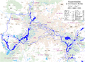
178:. Because it joins the Havel upstream of the river lock at Spandau, it provides a more direct route from the Spree to the
453:
36:
496:
193:) lies on the Berlin–Spandau Ship Canal some 4 kilometres (2.5 mi) from its eastern (River Spree) end. The
429:
284:
179:
144:
526:
198:
171:
107:
209:
288:
437:
384:
194:
128:
17:
202:
480:
167:
103:
212:
committed suicide by gunshot to the head on the banks of the canal following a long
213:
308:
348:
334:
186:
41:
View of the canal in April 2019, from the Berlin Tegel
Airport access road
163:
140:
93:
257:
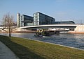
Barge entering the canal from the River Spree by the new
Hauptbahnhof
175:
136:
376:
159:
132:
89:
190:
143:. It was built between 1848 and 1859 to a plan created by
201:
also connect the port to the Spree further downstream in
189:, Berlin's largest port with an area of 173,000 m (42.75
441:
436:
This article about a Berlin building or structure is a
388:
502:
158:
The 12.2-kilometre (7.6 mi) long canal links the
99:
85:
80:
72:
64:
59:
51:
46:
29:
287:: Imray Laurie Norie & Wilson. p. 115.
461:
408:
383:This article related to water transport is a
8:
121:
468:
454:
415:
401:
26:
274:
272:
268:
223:
233:Map of waterways in the Berlin region
7:
426:
424:
373:
371:
512:Buildings and structures in Spandau
492:Berlin building and structure stubs
440:. You can help Knowledge (XXG) by
387:. You can help Knowledge (XXG) by
245:Information board on the promenade
123:Berlin-Spandauer Schifffahrtskanal
25:
507:Buildings and structures in Mitte
428:
375:
250:
238:
226:
147:, and was formerly known as the
35:
309:"The Internet as a Way of Life"
1:
517:Federal waterways in Germany
281:Inland Waterways of Germany
208:On August 26, 2013, author
543:
423:
370:
360:Spandauer-Schiffahrtskanal
279:Sheffield, Barry (1995).
122:
117:Berlin–Spandau Ship Canal
34:
30:Berlin–Spandau Ship Canal
18:Berlin-Spandau Ship Canal
55:12.2 km (7.6 miles)
522:Canals opened in 1859
487:Water transport stubs
199:Charlottenburg Canal
349:52.5366°N 13.3637°E
344: /
108:Berlin Hauptbahnhof
210:Wolfgang Herrndorf
149:Hohenzollern Canal
145:Peter Joseph Lenné
65:Construction began
449:
448:
396:
395:
153:Hohenzollernkanal
113:
112:
16:(Redirected from
534:
497:Canals in Berlin
470:
463:
456:
432:
425:
417:
410:
403:
379:
372:
368:
367:
365:
364:
363:
361:
356:
355:
354:52.5366; 13.3637
350:
345:
342:
341:
340:
337:
323:
322:
320:
319:
305:
299:
298:
276:
254:
242:
230:
180:Oder–Havel Canal
125:
124:
39:
27:
21:
542:
541:
537:
536:
535:
533:
532:
531:
477:
476:
475:
474:
422:
421:
359:
357:
353:
351:
347:
346:
343:
338:
335:
333:
331:
330:
329:
327:
326:
317:
315:
313:Goethe Institut
307:
306:
302:
295:
278:
277:
270:
265:
258:
255:
246:
243:
234:
231:
222:
195:Westhafen Canal
42:
23:
22:
15:
12:
11:
5:
540:
538:
530:
529:
524:
519:
514:
509:
504:
499:
494:
489:
479:
478:
473:
472:
465:
458:
450:
447:
446:
433:
420:
419:
412:
405:
397:
394:
393:
380:
325:
324:
300:
293:
267:
266:
264:
261:
260:
259:
256:
249:
247:
244:
237:
235:
232:
225:
221:
218:
203:Charlottenburg
111:
110:
101:
97:
96:
87:
83:
82:
78:
77:
74:
73:Date completed
70:
69:
66:
62:
61:
57:
56:
53:
49:
48:
47:Specifications
44:
43:
40:
32:
31:
24:
14:
13:
10:
9:
6:
4:
3:
2:
539:
528:
525:
523:
520:
518:
515:
513:
510:
508:
505:
503:
500:
498:
495:
493:
490:
488:
485:
484:
482:
471:
466:
464:
459:
457:
452:
451:
445:
443:
439:
434:
431:
427:
418:
413:
411:
406:
404:
399:
398:
392:
390:
386:
381:
378:
374:
369:
366:
314:
310:
304:
301:
296:
294:0-85288-283-1
290:
286:
282:
275:
273:
269:
262:
253:
248:
241:
236:
229:
224:
219:
217:
215:
211:
206:
204:
200:
196:
192:
188:
183:
181:
177:
173:
169:
165:
161:
156:
154:
150:
146:
142:
138:
134:
130:
126:
118:
109:
105:
102:
98:
95:
91:
88:
84:
79:
75:
71:
67:
63:
58:
54:
50:
45:
38:
33:
28:
19:
442:expanding it
435:
389:expanding it
382:
328:
316:. Retrieved
312:
303:
280:
207:
184:
172:Hauptbahnhof
157:
152:
148:
120:
116:
114:
527:Havel basin
352: /
168:River Spree
160:River Havel
104:River Spree
90:River Havel
86:Start point
481:Categories
358: (
339:13°21′49″E
336:52°32′12″N
318:2021-10-27
263:References
187:Westhafen
170:near the
162:north of
100:End point
92:north of
81:Geography
131:, is a
285:St Ives
220:Gallery
214:illness
166:to the
164:Spandau
141:Germany
94:Spandau
60:History
291:
176:Berlin
137:Berlin
129:German
52:Length
191:acres
133:canal
119:, or
106:near
438:stub
385:stub
289:ISBN
197:and
185:The
115:The
76:1859
68:1848
174:in
155:.
151:or
135:in
127:in
483::
311:.
283:.
271:^
216:.
205:.
182:.
139:,
469:e
462:t
455:v
444:.
416:e
409:t
402:v
391:.
362:)
321:.
297:.
20:)
Text is available under the Creative Commons Attribution-ShareAlike License. Additional terms may apply.