328:
29:
385:
233:. It is not navigable for the most part, but the section between Hamlin Lake and Lake Michigan is popular for tubing. It is considered an excellent river for fishing. It appears on maps as both "Big Sable" and "Big Sauble".
456:
369:
422:
446:
276:
168:
451:
362:
267:
95:
415:
355:
272:
461:
408:
441:
293:
242:
327:
262:
335:
222:
150:
218:
77:
226:
392:
339:
297:
28:
313:
435:
230:
146:
47:
384:
289:
U.S. Geological Survey. National
Hydrography Dataset high-resolution flowline data.
225:
counties. It is dammed to form Hamlin Lake, and below the dam continues through
131:
183:
170:
110:
97:
290:
214:
154:
81:
221:
in the chain of lakes known as Sauble Lakes and flows across Lake and
76:
confluence of Sauble Lakes chain and Bloody-Run Creek in
396:
343:
33:
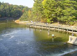
Fishing on the Big Sable, just below Hamlin Lake Dam
199:
160:
140:
130:
87:
70:
62:
53:
43:
38:
21:
391:This article related to a river in Michigan is a
416:
363:
8:
423:
409:
370:
356:
457:Lower Peninsula, Michigan geography stubs
277:United States Department of the Interior
213:is a 52-mile-long (84 km) river in
314:Michigan Streamflow Data from the USGS
254:
217:in the United States. It originates in
18:
7:
381:
379:
324:
322:
268:Geographic Names Information System
395:. You can help Knowledge (XXG) by
342:. You can help Knowledge (XXG) by
14:
447:Rivers of Mason County, Michigan
383:
326:
27:
273:United States Geological Survey
162: • coordinates
89: • coordinates
1:
54:Physical characteristics
452:Tributaries of Lake Michigan
300:, accessed November 21, 2011
142: • location
72: • location
478:
378:
321:
243:List of rivers of Michigan
16:River in the United States
126:
58:
26:
203:52 mi (84 km)
338:location article is a
336:Mason County, Michigan
111:44.060564°N 85.93646°W
184:44.03028°N 86.50703°W
462:Michigan river stubs
227:Ludington State Park
116:44.060564; -85.93646
189:44.03028; -86.50703
180: /
107: /
442:Rivers of Michigan
296:2012-03-29 at the
404:
403:
351:
350:
263:"Big Sable River"
207:
206:
469:
425:
418:
411:
387:
380:
372:
365:
358:
330:
323:
301:
291:The National Map
287:
281:
280:
259:
195:
194:
192:
191:
190:
185:
181:
178:
177:
176:
173:
122:
121:
119:
118:
117:
112:
108:
105:
104:
103:
100:
90:
73:
31:
19:
477:
476:
472:
471:
470:
468:
467:
466:
432:
431:
430:
429:
377:
376:
319:
310:
305:
304:
298:Wayback Machine
288:
284:
261:
260:
256:
251:
239:
211:Big Sable River
188:
186:
182:
179:
174:
171:
169:
167:
166:
163:
143:
115:
113:
109:
106:
101:
98:
96:
94:
93:
88:
71:
34:
22:Big Sable River
17:
12:
11:
5:
475:
473:
465:
464:
459:
454:
449:
444:
434:
433:
428:
427:
420:
413:
405:
402:
401:
388:
375:
374:
367:
360:
352:
349:
348:
331:
317:
316:
309:
308:External links
306:
303:
302:
282:
253:
252:
250:
247:
246:
245:
238:
235:
229:to empty into
205:
204:
201:
197:
196:
164:
161:
158:
157:
144:
141:
138:
137:
134:
128:
127:
124:
123:
91:
85:
84:
74:
68:
67:
64:
60:
59:
56:
55:
51:
50:
45:
41:
40:
36:
35:
32:
24:
23:
15:
13:
10:
9:
6:
4:
3:
2:
474:
463:
460:
458:
455:
453:
450:
448:
445:
443:
440:
439:
437:
426:
421:
419:
414:
412:
407:
406:
400:
398:
394:
389:
386:
382:
373:
368:
366:
361:
359:
354:
353:
347:
345:
341:
337:
332:
329:
325:
320:
315:
312:
311:
307:
299:
295:
292:
286:
283:
278:
274:
270:
269:
264:
258:
255:
248:
244:
241:
240:
236:
234:
232:
231:Lake Michigan
228:
224:
220:
216:
212:
202:
198:
193:
165:
159:
156:
152:
148:
147:Lake Michigan
145:
139:
135:
133:
129:
125:
120:
92:
86:
83:
79:
75:
69:
65:
61:
57:
52:
49:
48:United States
46:
42:
37:
30:
25:
20:
397:expanding it
390:
344:expanding it
333:
318:
285:
266:
257:
210:
208:
151:Mason County
219:Lake County
187: /
114: /
78:Lake County
436:Categories
249:References
175:86°30′25″W
172:44°01′49″N
102:85°56′11″W
99:44°03′38″N
294:Archived
237:See also
215:Michigan
155:Michigan
82:Michigan
39:Location
44:Country
200:Length
136:
66:
63:Source
334:This
223:Mason
132:Mouth
393:stub
340:stub
209:The
438::
275:,
271:.
265:.
153:,
149:,
80:,
424:e
417:t
410:v
399:.
371:e
364:t
357:v
346:.
279:.
Text is available under the Creative Commons Attribution-ShareAlike License. Additional terms may apply.