53:
65:
956:
149:
587:
In the township the population was spread out, with 23.5% under the age of 18, 6.5% from 18 to 24, 29.2% from 25 to 44, 26.1% from 45 to 64, and 14.7% who were 65 years of age or older. The median age was 40 years. For every 100 females, there were 96.6 males. For every 100 females age 18 and over,
583:
There were 515 households, out of which 30.1% had children under the age of 18 living with them, 65.0% were married couples living together, 6.4% had a female householder with no husband present, and 24.5% were non-families. 21.9% of all households were made up of individuals, and 10.5% had someone
576:, there were 1,317 people, 515 households, and 388 families residing in the township. The population density was 48.0 inhabitants per square mile (18.5/km). There were 540 housing units at an average density of 19.7/sq mi (7.6/km). The
52:
591:
The median income for a household in the township was $ 35,536, and the median income for a family was $ 42,500. Males had a median income of $ 35,625 versus $ 21,016 for females. The
1029:
829:
1024:
64:
989:
1375:
1069:
1044:
1014:
994:
249:, the township has a total area of 27.9 square miles (72 km), of which 27.4 square miles (71 km) is land and 0.5 square miles (1.3 km) (1.79%) is water.
1019:
974:
21:
999:
577:
1009:
1089:
1084:
1039:
1034:
1004:
979:
778:
1054:
703:
822:
580:
of the township was 99.32% White, 0.08% from other races, and 0.61% from two or more races. Hispanic or Latino of any race were 0.23% of the population.
206:
1157:
1079:
1064:
1049:
815:
1074:
1380:
1262:
1117:
615:
181:
97:
807:
645:
1302:
584:
living alone who was 65 years of age or older. The average household size was 2.55 and the average family size was 2.97.
1059:
839:
226:
102:
1345:
1197:
1152:
925:
910:
759:
711:
246:
1327:
1192:
1147:
234:
1312:
890:
885:
573:
538:
523:
508:
493:
478:
463:
448:
433:
418:
403:
388:
373:
358:
343:
328:
313:
298:
283:
230:
1317:
1287:
1202:
1132:
1112:
945:
915:
75:
17:
704:"Geographic Identifiers: 2010 Census Summary File 1 (G001): Black Lick township, Indiana County, Pennsylvania"
1252:
1232:
1122:
1099:
966:
935:
930:
900:
222:
43:
1307:
1292:
1272:
1267:
1222:
1162:
1142:
1137:
940:
872:
1277:
1247:
1187:
1182:
1107:
920:
861:
690:
1352:
1332:
1322:
1257:
1242:
1217:
905:
895:
880:
191:
1297:
1227:
1212:
1207:
1172:
1127:
1282:
1237:
595:
for the township was $ 16,766. About 7.8% of families and 10.0% of the population were below the
733:
665:
592:
677:
1369:
596:
90:
854:
85:
793:
780:
172:
599:, including 13.3% of those under age 18 and 8.3% of those age 65 or over.
57:
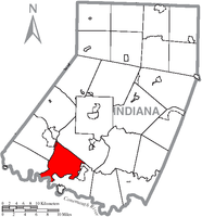
Map of
Indiana County, Pennsylvania, highlighting Black Lick Township
691:
http://www.usgwarchives.net/maps/pa/county/indian/usgs/blackbur.jpg
198:
177:
811:
954:
755:
639:
637:
635:
633:
233:. The township includes the communities of Grafton,
1171:
1098:
965:
871:
205:
188:
171:
163:
155:
142:
137:
129:
121:
113:
108:
96:
84:
74:
34:
229:, United States. The population was 1,133 at the
22:Blacklick Township, Cambria County, Pennsylvania
69:Map of Pennsylvania highlighting Indiana County
823:
8:
646:"City and Town Population Totals: 2020-2021"
830:
816:
808:
693:Partial Topographic map of Black Lick Area
256:
31:
1376:Townships in Indiana County, Pennsylvania
607:
204:
170:
136:
107:
73:
49:
29:Township in Pennsylvania, United States
673:
663:
276:
187:
162:
154:
141:
128:
125:27.33 sq mi (70.78 km)
120:
117:27.94 sq mi (72.36 km)
112:
95:
83:
61:
7:
710:. U.S. Census Bureau. Archived from
133:0.61 sq mi (1.59 km)
838:Municipalities and communities of
734:"Census of Population and Housing"
266:
14:
36:Black Lick Township, Pennsylvania
148:
147:
63:
51:
1:
618:. United States Census Bureau
841:Indiana County, Pennsylvania
227:Indiana County, Pennsylvania
760:United States Census Bureau
616:"2016 U.S. Gazetteer Files"
247:United States Census Bureau
167:43.22/sq mi (16.69/km)
156: • Estimate
1397:
15:
1381:Townships in Pennsylvania
1341:
952:
852:
565:
552:
537:
522:
507:
492:
477:
462:
447:
432:
417:
402:
387:
372:
357:
342:
327:
312:
297:
282:
275:
270:
265:
262:
62:
50:
41:
18:Black Lick, Pennsylvania
16:Not to be confused with
588:there were 94.2 males.
959:
958:
794:40.48333°N 79.28333°W
756:"U.S. Census website"
566:U.S. Decennial Census
258:Historical population
190: • Summer (
1354:United States portal
714:on February 13, 2020
164: • Density
1347:Pennsylvania portal
1118:Chevy Chase Heights
799:40.48333; -79.28333
790: /
708:American Factfinder
644:Bureau, US Census.
259:
219:Black Lick Township
960:
676:has generic name (
652:. US Census Bureau
257:
143: • Total
130: • Water
114: • Total
1363:
1362:
593:per capita income
570:
569:
245:According to the
216:
215:
122: • Land
1388:
1355:
1348:
957:
864:
857:
847:
842:
832:
825:
818:
809:
805:
804:
802:
801:
800:
795:
791:
788:
787:
786:
783:
771:
770:
768:
766:
752:
746:
745:
743:
741:
730:
724:
723:
721:
719:
700:
694:
688:
682:
681:
675:
671:
669:
661:
659:
657:
641:
628:
627:
625:
623:
612:
278:
273:
268:
260:
195:
151:
150:
67:
55:
32:
1396:
1395:
1391:
1390:
1389:
1387:
1386:
1385:
1366:
1365:
1364:
1359:
1353:
1346:
1337:
1303:Rochester Mills
1174:
1167:
1094:
1080:West Wheatfield
1030:East Wheatfield
961:
955:
950:
867:
862:
855:
848:
845:
840:
836:
798:
796:
792:
789:
784:
781:
779:
777:
776:
774:
764:
762:
754:
753:
749:
739:
737:
732:
731:
727:
717:
715:
702:
701:
697:
689:
685:
672:
662:
655:
653:
643:
642:
631:
621:
619:
614:
613:
609:
605:
271:
255:
243:
237:, and Newport.
189:
70:
58:
46:
37:
30:
25:
12:
11:
5:
1394:
1392:
1384:
1383:
1378:
1368:
1367:
1361:
1360:
1358:
1357:
1350:
1342:
1339:
1338:
1336:
1335:
1330:
1325:
1320:
1315:
1310:
1305:
1300:
1295:
1290:
1285:
1280:
1275:
1270:
1265:
1260:
1255:
1250:
1245:
1240:
1235:
1230:
1225:
1220:
1215:
1210:
1205:
1200:
1195:
1190:
1185:
1179:
1177:
1169:
1168:
1166:
1165:
1160:
1155:
1150:
1145:
1140:
1135:
1130:
1125:
1120:
1115:
1110:
1104:
1102:
1096:
1095:
1093:
1092:
1087:
1082:
1077:
1072:
1067:
1065:South Mahoning
1062:
1057:
1052:
1050:North Mahoning
1047:
1042:
1037:
1032:
1027:
1022:
1017:
1012:
1007:
1002:
997:
992:
987:
982:
977:
971:
969:
963:
962:
953:
951:
949:
948:
943:
938:
933:
928:
923:
918:
913:
908:
903:
898:
893:
888:
883:
877:
875:
869:
868:
853:
850:
849:
837:
835:
834:
827:
820:
812:
773:
772:
747:
725:
695:
683:
629:
606:
604:
601:
568:
567:
563:
562:
559:
557:
554:
550:
549:
546:
544:
541:
535:
534:
531:
529:
526:
520:
519:
516:
514:
511:
505:
504:
501:
499:
496:
490:
489:
486:
484:
481:
475:
474:
471:
469:
466:
460:
459:
456:
454:
451:
445:
444:
441:
439:
436:
430:
429:
426:
424:
421:
415:
414:
411:
409:
406:
400:
399:
396:
394:
391:
385:
384:
381:
379:
376:
370:
369:
366:
364:
361:
355:
354:
351:
349:
346:
340:
339:
336:
334:
331:
325:
324:
321:
319:
316:
310:
309:
306:
304:
301:
295:
294:
291:
289:
286:
280:
279:
274:
269:
264:
254:
251:
242:
239:
214:
213:
210:
203:
202:
196:
186:
185:
175:
169:
168:
165:
161:
160:
157:
153:
152:
144:
140:
139:
135:
134:
131:
127:
126:
123:
119:
118:
115:
111:
110:
106:
105:
100:
94:
93:
88:
82:
81:
78:
72:
71:
68:
60:
59:
56:
48:
47:
42:
39:
38:
35:
28:
13:
10:
9:
6:
4:
3:
2:
1393:
1382:
1379:
1377:
1374:
1373:
1371:
1356:
1351:
1349:
1344:
1343:
1340:
1334:
1331:
1329:
1326:
1324:
1321:
1319:
1316:
1314:
1311:
1309:
1306:
1304:
1301:
1299:
1296:
1294:
1291:
1289:
1286:
1284:
1281:
1279:
1276:
1274:
1271:
1269:
1266:
1264:
1261:
1259:
1256:
1254:
1251:
1249:
1246:
1244:
1241:
1239:
1236:
1234:
1231:
1229:
1226:
1224:
1221:
1219:
1216:
1214:
1211:
1209:
1206:
1204:
1201:
1199:
1198:Chambersville
1196:
1194:
1191:
1189:
1186:
1184:
1181:
1180:
1178:
1176:
1170:
1164:
1161:
1159:
1156:
1154:
1153:Lucerne Mines
1151:
1149:
1146:
1144:
1141:
1139:
1136:
1134:
1131:
1129:
1126:
1124:
1121:
1119:
1116:
1114:
1111:
1109:
1106:
1105:
1103:
1101:
1097:
1091:
1088:
1086:
1083:
1081:
1078:
1076:
1075:West Mahoning
1073:
1071:
1068:
1066:
1063:
1061:
1058:
1056:
1053:
1051:
1048:
1046:
1043:
1041:
1038:
1036:
1033:
1031:
1028:
1026:
1025:East Mahoning
1023:
1021:
1018:
1016:
1013:
1011:
1008:
1006:
1003:
1001:
998:
996:
993:
991:
988:
986:
983:
981:
978:
976:
973:
972:
970:
968:
964:
947:
944:
942:
939:
937:
934:
932:
929:
927:
926:Marion Center
924:
922:
919:
917:
914:
912:
911:Glen Campbell
909:
907:
904:
902:
899:
897:
894:
892:
889:
887:
884:
882:
879:
878:
876:
874:
870:
866:
865:
858:
851:
846:United States
843:
833:
828:
826:
821:
819:
814:
813:
810:
806:
803:
761:
757:
751:
748:
735:
729:
726:
713:
709:
705:
699:
696:
692:
687:
684:
679:
667:
651:
647:
640:
638:
636:
634:
630:
617:
611:
608:
602:
600:
598:
594:
589:
585:
581:
579:
578:racial makeup
575:
564:
560:
558:
555:
551:
547:
545:
542:
540:
536:
532:
530:
527:
525:
521:
517:
515:
512:
510:
506:
502:
500:
497:
495:
491:
487:
485:
482:
480:
476:
472:
470:
467:
465:
461:
457:
455:
452:
450:
446:
442:
440:
437:
435:
431:
427:
425:
422:
420:
416:
412:
410:
407:
405:
401:
397:
395:
392:
390:
386:
382:
380:
377:
375:
371:
367:
365:
362:
360:
356:
352:
350:
347:
345:
341:
337:
335:
332:
330:
326:
322:
320:
317:
315:
311:
307:
305:
302:
300:
296:
292:
290:
287:
285:
281:
261:
252:
250:
248:
240:
238:
236:
232:
228:
224:
220:
211:
208:
200:
197:
193:
183:
182:Eastern (EST)
179:
176:
174:
166:
158:
145:
132:
124:
116:
104:
101:
99:
92:
89:
87:
80:United States
79:
77:
66:
54:
45:
40:
33:
27:
23:
19:
1328:West Lebanon
1193:Brush Valley
1148:Jacksonville
990:Brush Valley
984:
860:
775:
763:. Retrieved
750:
738:. Retrieved
736:. Census.gov
728:
716:. Retrieved
712:the original
707:
698:
686:
674:|last1=
654:. Retrieved
649:
620:. Retrieved
610:
597:poverty line
590:
586:
582:
571:
253:Demographics
244:
235:Jacksonville
218:
217:
212:42-063-06752
91:Pennsylvania
26:
1313:Strongstown
1175:communities
891:Cherry Tree
886:Blairsville
856:County seat
797: /
765:January 31,
574:2000 census
553:2021 (est.)
231:2020 census
1370:Categories
1318:Trade City
1288:Northpoint
1203:Clarksburg
1133:Dixonville
1113:Black Lick
1070:Washington
1045:Montgomery
1015:Cherryhill
995:Buffington
985:Black Lick
946:Smicksburg
916:Homer City
785:79°17′00″W
782:40°29′00″N
650:Census.gov
622:August 14,
603:References
572:As of the
138:Population
1253:Josephine
1233:Hillsdale
1123:Commodore
1020:Conemaugh
975:Armstrong
967:Townships
936:Saltsburg
931:Plumville
901:Creekside
718:April 10,
241:Geography
173:Time zone
1308:Starford
1293:Penn Run
1273:McIntyre
1268:Marchand
1223:Dilltown
1163:Rossiter
1158:Robinson
1143:Heilwood
1138:Graceton
941:Shelocta
873:Boroughs
666:cite web
223:township
44:Township
1278:Mentcle
1248:Jewtown
1188:Aultman
1183:Arcadia
1108:Alverda
1000:Burrell
921:Indiana
863:Indiana
740:June 4,
656:July 6,
103:Indiana
76:Country
1333:Wilgus
1323:Wehrum
1258:Locust
1243:Iselin
1218:Covode
1010:Center
906:Ernest
896:Clymer
881:Armagh
458:−12.0%
443:−13.0%
413:−13.3%
323:−10.1%
308:−44.7%
263:Census
146:1,133
98:County
1298:Rexis
1228:Gipsy
1213:Clyde
1208:Clune
1173:Other
1128:Coral
1090:Young
1085:White
1060:Rayne
1040:Green
1035:Grant
1005:Canoe
980:Banks
561:−0.4%
556:1,128
548:−8.4%
543:1,133
533:−6.1%
528:1,237
513:1,317
498:1,225
488:26.9%
483:1,164
473:33.9%
428:−4.4%
398:34.8%
393:1,078
368:−8.3%
353:−6.0%
338:−9.1%
318:1,016
303:1,130
288:2,043
221:is a
201:(EDT)
199:UTC-4
178:UTC-5
159:1,128
86:State
1283:Nolo
1263:Loop
1238:Home
1100:CDPs
1055:Pine
767:2008
742:2016
720:2018
678:help
658:2022
624:2017
539:2020
524:2010
518:7.5%
509:2000
503:5.2%
494:1990
479:1980
464:1970
449:1960
434:1950
419:1940
404:1930
389:1920
383:0.4%
374:1910
359:1900
344:1890
329:1880
314:1870
299:1860
284:1850
272:Note
267:Pop.
209:code
207:FIPS
109:Area
468:917
453:685
438:778
423:894
408:935
378:800
363:797
348:869
333:924
225:in
192:DST
20:or
1372::
859::
844:,
758:.
706:.
670::
668:}}
664:{{
648:.
632:^
277:%±
831:e
824:t
817:v
769:.
744:.
722:.
680:)
660:.
626:.
293:—
194:)
184:)
180:(
24:.
Text is available under the Creative Commons Attribution-ShareAlike License. Additional terms may apply.