52:
36:
59:
435:
The upper river receives
Quentin Creek from the right before crossing the border into Lane County. Just southwest of the border, the river receives Cook Creek, also from the right. Just beyond RM 9 (RK 14), the river passes under Forest Road 15 and receives Tidbits Creek from the right. At
447:
A fraction of a mile beyond the mouth of Mona Creek, Lookout Creek enters from the left near the
Lookout Campground and Boat Launch, and Mona Campground is on the right. Blue River and the reservoir curve to the southwest, and Scott Creek enters from the right at RM 5 (RK 8). On the
419:
Blue River begins on the western slopes of the
Cascade Range at the confluence of Mann and Wolf creeks in Linn County, slightly north of its border with Lane County. Descending from an elevation of about 2,500 feet (760 m) above sea level, the river flows generally southwest through the
455:
As Blue River nears Blue River Dam, about 2 miles (3 km) from the mouth, Quartz Creek and North Fork Quartz Creek enter from the right. Below the dam, Forest Road 125 runs parallel to the river along its right bank. The river passes a
570:
for the first 9 miles (14 km) of the Blue River. The remaining distance is an estimate based on map scale and ruler. The relevant quadrangles are, from mouth to source, Blue River, McKenzie Bridge, and
Carpenter
460:
stream gauge below the dam, and then
Simmonds Creek enters from the right. Blue River joins the McKenzie River at the community of Blue River, 57 miles (92 km) from the McKenzie's confluence with the
448:
opposite shore at this point is Saddle Dam and its boat launch, which lie outside the national forest. At this point, Forest Road 15 leaves the river and the reservoir and heads south to
707:
581:
51:
758:
393:
504:
235:
691:
653:
457:
553:
154:
644:
Johnson, Daniel M.; Petersen, Richard R.; Lycan, D. Richard; Sweet, James W.; Neuhaus, Mark E.; Schaedel, Andrew L. (1985).
588:
400:
132:
738:
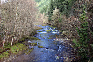
753:
683:
444:, the river receives Mona Creek from the right and passes under Forest Road 120, which leads to Mona Campground.
474:
499:
678:
357:
205:
712:
389:
365:
361:
221:
140:
103:
99:
35:
381:
217:
20:
687:
673:
669:
649:
411:. Blue River was named for the striking blue color that apparently comes from its rocky bed.
462:
449:
616:
404:
421:
747:
377:
136:
16:
Tributary of the McKenzie River in Linn and Lane counties in the U.S. state of Oregon
528:
384:. Saddle Dam and Blue River Dam block the river about 2 miles (3 km) from its
440:. Just before entering Blue River Reservoir, about 8 miles (13 km) from the
441:
425:
408:
385:
311:
200:
567:
437:
429:
369:
436:
this point, the river turns sharply south, and Forest Road 15 runs along its
250:
237:
169:
156:
708:"Indians, Surveyors, Incidents Gave Names to Streams, Lakes and Mountains"
380:, it flows generally southwest to join the McKenzie near the community of
587:. Oregon Department of Environmental Quality. p. 6. Archived from
373:
617:"Water-Data Report 2011: USGS 14162200 Blue River at Blue River, OR"
376:. From its source at the confluence of Mann and Wolf creeks in the
648:. Corvallis: Oregon State University Press. p. 157.
547:
545:
543:
541:
539:
537:
399:
The river's watershed lies almost entirely within the
509:. United States Geological Survey. November 28, 1980
337:
327:
317:
304:
296:
284:
276:
266:
227:
211:
199:
185:
146:
126:
118:
109:
95:
87:
79:
74:
28:
392:, a multipurpose impoundment built in 1968 by the
310:near Blue River, 0.9 miles (1.4 km) from the
639:
637:
554:"United States Geological Survey Topographic Map"
66:Location of the mouth of the Blue River in Oregon
432:(RM) 9 or river kilometer (RK) 14.
8:
611:
609:
58:
582:"Willamette Basin TMDL: McKenzie Subbasin"
552:United States Geological Survey (USGS).
486:
333:0.80 cu ft/s (0.023 m/s)
122:Confluence of Wolf Creek and Mann Creek
494:
492:
490:
343:7,270 cu ft/s (206 m/s)
25:
531:search using GNIS source coordinates.
424: 15 follows the river along its
394:United States Army Corps of Engineers
323:457 cu ft/s (12.9 m/s)
7:
505:Geographic Names Information System
682:(7th ed.). Portland, Oregon:
14:
622:. United States Geological Survey
288:87 sq mi (230 km)
57:
50:
34:
458:United States Geological Survey
527:Source elevation derived from
229: • coordinates
148: • coordinates
1:
759:Rivers of Lane County, Oregon
110:Physical characteristics
716:. January 4, 1942. p. 5
420:Willamette National Forest.
268: • elevation
187: • elevation
306: • location
213: • location
128: • location
775:
739:McKenzie Watershed Council
401:Willamette National Forest
339: • maximum
329: • minimum
319: • average
272:1,040 ft (320 m)
191:2,504 ft (763 m)
133:Willamette National Forest
40:Flowing through the forest
18:
684:Oregon Historical Society
428:from its source to about
347:
292:
195:
114:
45:
33:
475:List of rivers of Oregon
679:Oregon Geographic Names
280:17 mi (27 km)
19:For the community, see
356:is a tributary of the
251:44.15417°N 122.34500°W
170:44.29472°N 122.17139°W
713:Eugene Register-Guard
646:Atlas of Oregon Lakes
566:Map quadrangles show
390:Blue River Reservoir
256:44.15417; -122.34500
175:44.29472; -122.17139
686:Press. p. 93.
247: /
166: /
674:McArthur, Lewis L.
670:McArthur, Lewis A.
21:Blue River, Oregon
351:
350:
766:
754:Rivers of Oregon
726:
725:
723:
721:
704:
698:
697:
666:
660:
659:
641:
632:
631:
629:
627:
621:
613:
604:
603:
601:
599:
593:
586:
578:
572:
565:
563:
561:
549:
532:
525:
519:
518:
516:
514:
496:
463:Willamette River
450:Oregon Route 126
368:counties in the
340:
330:
320:
307:
262:
261:
259:
258:
257:
252:
248:
245:
244:
243:
240:
188:
181:
180:
178:
177:
176:
171:
167:
164:
163:
162:
159:
149:
129:
61:
60:
54:
38:
26:
774:
773:
769:
768:
767:
765:
764:
763:
744:
743:
735:
730:
729:
719:
717:
706:
705:
701:
694:
668:
667:
663:
656:
643:
642:
635:
625:
623:
619:
615:
614:
607:
597:
595:
591:
584:
580:
579:
575:
559:
557:
551:
550:
535:
526:
522:
512:
510:
498:
497:
488:
483:
471:
417:
405:western hemlock
403:, dominated by
338:
328:
318:
305:
269:
255:
253:
249:
246:
241:
238:
236:
234:
233:
230:
214:
186:
174:
172:
168:
165:
160:
157:
155:
153:
152:
147:
127:
70:
69:
68:
67:
64:
63:
62:
41:
24:
17:
12:
11:
5:
772:
770:
762:
761:
756:
746:
745:
742:
741:
734:
733:External links
731:
728:
727:
699:
693:978-0875952772
692:
661:
654:
633:
605:
573:
533:
520:
485:
484:
482:
479:
478:
477:
470:
467:
416:
413:
358:McKenzie River
349:
348:
345:
344:
341:
335:
334:
331:
325:
324:
321:
315:
314:
308:
302:
301:
298:
294:
293:
290:
289:
286:
282:
281:
278:
274:
273:
270:
267:
264:
263:
231:
228:
225:
224:
215:
212:
209:
208:
206:McKenzie River
203:
197:
196:
193:
192:
189:
183:
182:
150:
144:
143:
130:
124:
123:
120:
116:
115:
112:
111:
107:
106:
97:
93:
92:
89:
85:
84:
81:
77:
76:
72:
71:
65:
56:
55:
49:
48:
47:
46:
43:
42:
39:
31:
30:
15:
13:
10:
9:
6:
4:
3:
2:
771:
760:
757:
755:
752:
751:
749:
740:
737:
736:
732:
715:
714:
709:
703:
700:
695:
689:
685:
681:
680:
675:
671:
665:
662:
657:
655:0-87071-343-4
651:
647:
640:
638:
634:
618:
612:
610:
606:
594:on 2016-05-09
590:
583:
577:
574:
569:
568:river mileage
555:
548:
546:
544:
542:
540:
538:
534:
530:
524:
521:
508:
506:
501:
495:
493:
491:
487:
480:
476:
473:
472:
468:
466:
464:
459:
453:
451:
445:
443:
439:
433:
431:
427:
423:
414:
412:
410:
406:
402:
397:
395:
391:
387:
383:
379:
378:Cascade Range
375:
371:
367:
363:
359:
355:
346:
342:
336:
332:
326:
322:
316:
313:
309:
303:
299:
295:
291:
287:
283:
279:
275:
271:
265:
260:
232:
226:
223:
219:
216:
210:
207:
204:
202:
198:
194:
190:
184:
179:
151:
145:
142:
138:
137:Cascade Range
134:
131:
125:
121:
117:
113:
108:
105:
101:
98:
94:
90:
86:
83:United States
82:
78:
73:
53:
44:
37:
32:
27:
22:
718:. Retrieved
711:
702:
677:
664:
645:
626:December 26,
624:. Retrieved
598:December 26,
596:. Retrieved
589:the original
576:
560:December 26,
558:. Retrieved
529:Google Earth
523:
513:December 26,
511:. Retrieved
503:
500:"Blue River"
454:
446:
434:
418:
398:
353:
352:
556:. TopoQuest
422:Forest Road
409:Douglas-fir
254: /
242:122°20′42″W
222:Lane County
173: /
161:122°10′17″W
141:Linn County
748:Categories
481:References
430:river mile
426:right bank
382:Blue River
370:U.S. state
354:Blue River
285:Basin size
239:44°09′15″N
218:Blue River
158:44°17′41″N
29:Blue River
720:April 23,
676:(2003) .
571:Mountain.
438:left bank
297:Discharge
469:See also
388:to form
75:Location
80:Country
690:
652:
507:(GNIS)
415:Course
374:Oregon
300:
277:Length
119:Source
96:County
91:Oregon
620:(PDF)
592:(PDF)
585:(PDF)
442:mouth
386:mouth
312:mouth
201:Mouth
88:State
722:2015
688:ISBN
650:ISBN
628:2012
600:2012
562:2012
515:2012
407:and
366:Lane
364:and
362:Linn
104:Linn
102:and
100:Lane
372:of
360:in
750::
710:.
672:;
636:^
608:^
536:^
502:.
489:^
465:.
452:.
396:.
220:,
139:,
135:,
724:.
696:.
658:.
630:.
602:.
564:.
517:.
23:.
Text is available under the Creative Commons Attribution-ShareAlike License. Additional terms may apply.