108:
115:
26:
226:
204:. The Bobenthaler Kopf is covered by mixed woods. A footpath leads to the summit from the south. It forms the centre of the 319 hectares (790 acres) Bobenthaler Knopf Core Zone in the
302:
297:
107:
196:, from which it derives its name. It lies about 2 kilometres (1.2 mi) east of the main settlement. In the west it descends relatively gently to the valley of the
64:
249:
245:
Bundesamt für
Kartographie und Geodäsie, Landesamt für Vermessung und Geobasisinformation Rheinland-Pfalz: Digital Topographic Map 1:50,000,
266:
Landesverordnung über den „Naturpark Pfälzerwald“ als deutscher Teil des Biosphärenreservats Pfälzerwald-Nordvogesen dated 22 January 2007
265:
30:
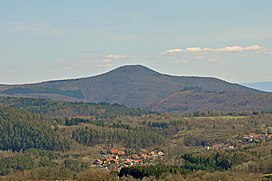
View of the
Bobenthaler Knopf from Napoleon Rock. Foreground: the municipality of Bundenthal; right rear: the northern Black Forest.
57:
205:
246:
165:
48:
201:
127:
25:
253:
174:
150:
197:
143:
291:
225:
210:
200:
stream; in the east it drops considerably more steeply into the valley of the
79:
66:
193:
278:
192:
The hill is located entirely within the territory of the municipality of
178:
131:
186:
182:
170:
41:
224:
173:, the name given to the region covering the southern part of the
208:. About 1.5 kilometres (0.93 mi) to the south lie the
142:
95:
56:
40:
35:
18:
8:
303:Mountains and hills of the Palatinate Forest
298:Mountains and hills of Rhineland-Palatinate
15:
114:
238:
169:(1,752 ft), in the southeastern
7:
14:
113:
106:
24:
229:The Bobenthaler Knopf in winter
162:("Bobenthal Knob") is a hill,
1:
181:and the northern part of the
268:, retrieved 26 November 2009
256:, retrieved 26 November 2009
206:Palatine Forest Nature Park
319:
100:
23:
252:July 23, 2007, at the
230:
228:
220:Eselsschleifhäuschen
128:Rhineland-Palatinate
80:49.0675°N 7.87583°E
76: /
247:Deutschland Viewer
231:
36:Highest point
279:"Rittersteine.de"
166:m above sea level
160:Bobenthaler Knopf
156:
155:
121:Bobenthaler Knopf
49:m above sea level
19:Bobenthaler Knopf
310:
283:
282:
275:
269:
263:
257:
243:
168:
146:
117:
116:
110:
91:
90:
88:
87:
86:
85:49.0675; 7.87583
81:
77:
74:
73:
72:
69:
51:
28:
16:
318:
317:
313:
312:
311:
309:
308:
307:
288:
287:
286:
277:
276:
272:
264:
260:
254:Wayback Machine
244:
240:
236:
175:Palatine Forest
163:
151:Palatine Forest
144:
138:
137:
136:
135:
134:
125:
124:
123:
122:
118:
84:
82:
78:
75:
70:
67:
65:
63:
62:
52:(1,752 ft)
46:
31:
12:
11:
5:
316:
314:
306:
305:
300:
290:
289:
285:
284:
270:
258:
237:
235:
232:
154:
153:
148:
140:
139:
126:
120:
119:
112:
111:
105:
104:
103:
102:
101:
98:
97:
93:
92:
60:
54:
53:
44:
38:
37:
33:
32:
29:
21:
20:
13:
10:
9:
6:
4:
3:
2:
315:
304:
301:
299:
296:
295:
293:
280:
274:
271:
267:
262:
259:
255:
251:
248:
242:
239:
233:
227:
223:
221:
217:
213:
212:
207:
203:
199:
195:
190:
188:
184:
180:
176:
172:
167:
161:
152:
149:
147:
141:
133:
129:
109:
99:
94:
89:
61:
59:
55:
50:
45:
43:
39:
34:
27:
22:
17:
273:
261:
241:
219:
215:
211:Rittersteins
209:
191:
159:
157:
145:Parent range
216:Löffelkreuz
83: /
58:Coordinates
292:Categories
234:References
198:Wieslauter
68:49°04′03″N
194:Bobenthal
164:534
96:Geography
71:7°52′33″E
47:534
42:Elevation
250:Archived
202:Reisbach
179:Germany
132:Germany
187:France
183:Vosges
171:Wasgau
218:and
158:The
214:of
185:in
177:in
294::
222:.
189:.
130:,
281:.
Text is available under the Creative Commons Attribution-ShareAlike License. Additional terms may apply.