55:
39:
62:
203:
At the right hand side of the cove there is a cave that is about 60 feet in height at the entrance but only 15–20 wide. It opens up into a large cavern with two more caverns which become very dark. The cave continues after this point but the floor becomes rock and very uneven. It has been said there
199:
An unusual part of the cliff is known as the
Elephant Rock, where a high vertical arch has formed almost separating a ″narrow trunk of rock from the mainland″. This feature shows the relationship of vertical jointing to cliff features. The cove has a sandy beach which is completely covered by the
243:
231:
174:
54:
38:
207:
Access to the beach is by steep steps, a route which is not suitable for wheelchairs or push chairs. There is no lifeguard coverage.
178:
86:
285:
295:
254:
177:
designated for its geological and wildlife interests. The cove is at the northern point of the
Tintagel
167:
182:
290:
227:
190:
134:
193:
186:
185:, and for its hard rock coastal landforms. The cove is open to northerly winds off the
279:
151:
101:
88:
163:
159:
155:
146:
121:
196:
of
Willapark to the north. At low tide it is linked to Benoath Cove.
162:, United Kingdom and a mile east of Tintagel and three miles west of
29:
175:
Tintagel Cliffs Site of
Special Scientific Interest (SSSI)
117:
20:
181:site, chosen because it is a good example of a
8:
223:Ordnance Survey: Landranger map sheet 200
170:closely follows the coast above the cove.
17:
216:
116:
47:
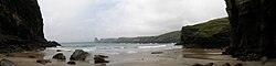
43:Panorama of Bossiney Haven on a wet day
35:
61:
7:
14:
60:
53:
37:
179:Geological Conservation Review
173:Bossiney Haven is part of the
158:. It is on the north coast of
1:
204:is a waterfall in the cave.
312:
150:) is a small cove in the
82:
48:
36:
27:
189:and is flanked by the
138:
168:South West Coast Path
225:Newquay & Bodmin
74:Location in Cornwall
286:Beaches of Cornwall
200:tide at high water
98: /
260:on 24 October 2012
183:longitudinal coast
296:Coves of Cornwall
244:"Tintagel Cliffs"
232:978-0-319-22938-5
128:
127:
303:
270:
269:
267:
265:
259:
253:. Archived from
248:
240:
234:
221:
113:
112:
110:
109:
108:
103:
102:50.671°N 4.735°W
99:
96:
95:
94:
91:
64:
63:
57:
41:
18:
311:
310:
306:
305:
304:
302:
301:
300:
276:
275:
274:
273:
263:
261:
257:
251:Natural England
246:
242:
241:
237:
222:
218:
213:
106:
104:
100:
97:
92:
89:
87:
85:
84:
78:
77:
76:
75:
72:
71:
70:
69:
65:
44:
32:
23:
12:
11:
5:
309:
307:
299:
298:
293:
288:
278:
277:
272:
271:
235:
215:
214:
212:
209:
131:Bossiney Haven
126:
125:
119:
115:
114:
107:50.671; -4.735
80:
79:
73:
68:Bossiney Haven
67:
66:
59:
58:
52:
51:
50:
49:
46:
45:
42:
34:
33:
28:
25:
24:
22:Bossiney Haven
21:
13:
10:
9:
6:
4:
3:
2:
308:
297:
294:
292:
289:
287:
284:
283:
281:
256:
252:
245:
239:
236:
233:
229:
226:
220:
217:
210:
208:
205:
201:
197:
195:
192:
188:
184:
180:
176:
171:
169:
165:
161:
157:
153:
149:
148:
142:
141:
140:Porth Boskyny
136:
132:
123:
120:
111:
83:Coordinates:
81:
56:
40:
31:
26:
19:
16:
262:. Retrieved
255:the original
250:
238:
224:
219:
206:
202:
198:
194:cliff castle
172:
152:civil parish
144:
139:
130:
129:
15:
105: /
280:Categories
211:References
143:, meaning
90:50°40′16″N
164:Boscastle
93:4°44′06″W
291:Tintagel
264:14 March
191:Iron Age
187:Atlantic
160:Cornwall
156:Tintagel
147:Bossiney
145:cove at
122:Cornwall
118:Location
135:Cornish
230:
166:. The
258:(PDF)
247:(PDF)
266:2015
228:ISBN
124:, UK
30:Cove
154:of
282::
249:.
137::
268:.
133:(
Text is available under the Creative Commons Attribution-ShareAlike License. Additional terms may apply.