46:
38:
84:
The
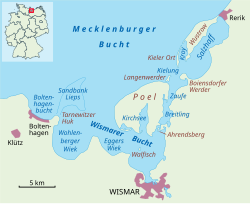
Breitling is a very shallow body of water, mostly under one metre in depth. Large parts can even become exposed at low water, whereas at high water it can cover the low-lying causeway known as the Poeldamm. In the south the road link runs along a
125:
140:
89:(the Poeldamm) over a low peninsula to Poel over the Breitling. The waterbody is about five kilometres long and no more than one kilometre wide.
97:
The landscape alternates between short stretches of steep shoreline on the mainland side, on the southern shores of the small islands of
184:
113:. The higher areas are usually very dry and are characterised by arid vegetation such as poor, dry grassland with thorn bushes.
70:
122:
45:
179:
31:
129:
105:
and very shallow areas subject to flooding. This is indicated by salt grasslands with
173:
74:
37:
17:
102:
62:
155:
142:
106:
86:
78:
110:
58:
44:
66:
81:(into which estuaries of the Zaufe and Gollwitz empty).
69:
and the mainland in the northeast of the district of
8:
49:The Breitling between Poel and the mainland
41:The Breitling as part of the Bay of Wismar
77:, beginning south of Poeldamm, with the
36:
109:islands and shores, interspersed with
73:. It links the sheltered part of the
30:For the bay on the River Warnow, see
7:
25:
1:
201:
123:Bay of Wismar conservation
29:
185:Straits of the Baltic Sea
27:Strait in the Baltic Sea
65:between the island of
50:
42:
48:
40:
152: /
71:Nordwestmecklenburg
18:Breitling (channel)
128:2011-03-11 at the
51:
43:
32:Breitling (Warnow)
156:53.983°N 11.483°E
16:(Redirected from
192:
167:
166:
164:
163:
162:
157:
153:
150:
149:
148:
145:
134:
21:
200:
199:
195:
194:
193:
191:
190:
189:
170:
169:
160:
158:
154:
151:
146:
143:
141:
139:
138:
132:
130:Wayback Machine
119:
95:
93:Flora and fauna
35:
28:
23:
22:
15:
12:
11:
5:
198:
196:
188:
187:
182:
172:
171:
161:53.983; 11.483
136:
135:
118:
117:External links
115:
94:
91:
26:
24:
14:
13:
10:
9:
6:
4:
3:
2:
197:
186:
183:
181:
180:Bay of Wismar
178:
177:
175:
168:
165:
131:
127:
124:
121:
120:
116:
114:
112:
108:
104:
100:
92:
90:
88:
82:
80:
76:
75:Bay of Wismar
72:
68:
64:
60:
56:
47:
39:
33:
19:
137:
98:
96:
83:
57:is a narrow
54:
52:
159: /
133:(in German)
103:Ahrendsberg
174:Categories
99:Baumwerder
63:Baltic Sea
55:Breitling
126:Archived
107:alluvial
87:causeway
79:Salzhaff
147:11°29′E
144:53°59′N
61:in the
111:creeks
59:strait
101:and
67:Poel
53:The
176::
34:.
20:)
Text is available under the Creative Commons Attribution-ShareAlike License. Additional terms may apply.