29:
206:. Zapata Swamp has an area of 450 km. It lies between 22º01’ and 22º40’ N latitude and 80º33’ and 82º09’ W longitude in southern Matanzas province. The swamp extends 175 km east and west from Punta Gorda to Jagua, with an average width of 14 to 16 km, reaching a maximum width of 58 km from southern Torriente to Cayo Miguel.
43:
355:
Eric
Dinerstein, David Olson, et al. (2017). An Ecoregion-Based Approach to Protecting Half the Terrestrial Realm, BioScience, Volume 67, Issue 6, June 2017, pp. 534–545; Supplemental material 2 table S1b.
413:
300:
403:
255:
Plant communities include floating vegetation in areas of deeper water, permanently and seasonally flooded grasslands, and swamp forests.
183:
The Cuban wetlands are found on lowland floodplains on island's northern and southern (Caribbean) shores. Most are fringed with
418:
165:
75:
141:
175:
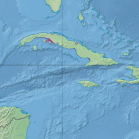
and nearby smaller islands. The ecoregion covers 5,631 km (2,174 sq mi), about 4% of the island's area.
408:
184:
103:
218:
214:
222:
226:
210:
199:
98:
58:
233:
93:
195:
88:
63:
237:
203:
383:
225:
in Ciego de Ávila and Camagüey provinces, and Birama Inlet and
Leonero Lagoon along the
284:
28:
397:
244:
191:
33:
372:
335:
388:
272:
264:
42:
168:
280:
357:
299:
3,306 km, or 59%, of the ecoregion is in protected areas, including
291:) lives in the Zapata Swamp and adjacent forests and cactus scrub.
70:
172:
129:
232:
On the northern shore, the larger wetlands are around the
209:Other wetlands along Cuba's southern shore include
150:
140:
135:
125:
117:
112:
81:
69:
57:
52:
21:
8:
351:
349:
247:, which lies south of the Cuban mainland.
312:
389:Cuban wetlands (Encyclopedia of Earth)
18:
330:
328:
326:
324:
322:
320:
318:
316:
121:5,631 km (2,174 sq mi)
7:
301:Ciénaga de Zapata Biosphere Reserve
190:The largest wetland in Cuba is the
14:
236:in Matanzas Province, and around
41:
27:
414:Flooded grasslands and savannas
198:, and extending west along the
166:flooded grasslands and savannas
76:flooded grasslands and savannas
47:Ecoregion territory (in purple)
1:
240:in Ciego de Ávila Province.
404:Ecoregions of the Caribbean
217:in the western province of
435:
104:Greater Antilles mangroves
283:to the Zapata Swamp. The
40:
26:
243:Lanier Swamp is on the
419:Neotropical ecoregions
379:. World Wildlife Fund.
377:Terrestrial Ecoregions
342:. World Wildlife Fund.
340:Terrestrial Ecoregions
289:Torreornis inexpectata
215:Alcatraz Grande Lagoon
194:, located in southern
384:Cuban wetlands (DOPA)
277:Cyanolimnas cerverai
227:Gulf of Guacanayabo
187:nearer to the sea.
146:Critical/endangered
142:Conservation status
99:Cuban moist forests
409:Ecoregions of Cuba
234:Bay of Santa Clara
94:Cuban pine forests
223:Gulf of Ana María
196:Matanzas Province
171:on the island of
158:
157:
89:Cuban dry forests
16:Ecoregion in Cuba
426:
380:
373:"Cuban wetlands"
359:
353:
344:
343:
336:"Cuban wetlands"
332:
269:Fermina cerverai
200:Gulf of Batabanó
45:
31:
19:
434:
433:
429:
428:
427:
425:
424:
423:
394:
393:
371:
368:
363:
362:
354:
347:
334:
333:
314:
309:
297:
295:Protected areas
261:
253:
238:Laguna de Leche
204:Havana Province
181:
108:
48:
36:
17:
12:
11:
5:
432:
430:
422:
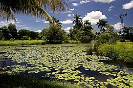
421:
416:
411:
406:
396:
395:
392:
391:
386:
381:
367:
366:External links
364:
361:
360:
345:
311:
310:
308:
305:
296:
293:
285:Zapata sparrow
260:
257:
252:
249:
202:into southern
180:
177:
162:Cuban wetlands
156:
155:
154:3,306 km (59%)
152:
148:
147:
144:
138:
137:
133:
132:
127:
123:
122:
119:
115:
114:
110:
109:
107:
106:
101:
96:
91:
85:
83:
79:
78:
73:
67:
66:
61:
55:
54:
50:
49:
46:
38:
37:
32:
24:
23:
22:Cuban wetlands
15:
13:
10:
9:
6:
4:
3:
2:
431:
420:
417:
415:
412:
410:
407:
405:
402:
401:
399:
390:
387:
385:
382:
378:
374:
370:
369:
365:
358:
352:
350:
346:
341:
337:
331:
329:
327:
325:
323:
321:
319:
317:
313:
306:
304:
302:
294:
292:
290:
286:
282:
278:
274:
270:
267:or ferminia (
266:
258:
256:
250:
248:
246:
245:Isle of Youth
241:
239:
235:
230:
228:
224:
221:, around the
220:
219:Pinar del Río
216:
212:
211:Pesquero Lake
207:
205:
201:
197:
193:
188:
186:
178:
176:
174:
170:
167:
163:
153:
149:
145:
143:
139:
134:
131:
128:
124:
120:
116:
111:
105:
102:
100:
97:
95:
92:
90:
87:
86:
84:
80:
77:
74:
72:
68:
65:
62:
60:
56:
51:
44:
39:
35:
30:
25:
20:
376:
339:
298:
288:
276:
268:
262:
254:
242:
231:
208:
192:Zapata Swamp
189:
182:
161:
159:
136:Conservation
34:Zapata Swamp
273:Zapata rail
265:Zapata wren
64:Neotropical
398:Categories
307:References
271:) and the
185:mangroves
179:Geography
169:ecoregion
151:Protected
113:Geography
281:endemic
126:Country
82:Borders
53:Ecology
279:) are
259:Fauna
251:Flora
164:is a
71:Biome
59:Realm
263:The
213:and
173:Cuba
160:The
130:Cuba
118:Area
400::
375:.
348:^
338:.
315:^
303:.
229:.
287:(
275:(
Text is available under the Creative Commons Attribution-ShareAlike License. Additional terms may apply.