742:
777:, Harley Gulch, and Davis Creek. Reports like this led to protocols set in place to monitor the mercury levels within Cache Creek and warn the public of possible health concerns from fish consumption. In 2017, The Department of Environmental Science and Policy from UC Davis, in consultation with The Yolo County Cache Creek Technical Advisory Committee, proposed revisions to the existing protocols. The revision proposal called for yearly monitoring of off channel wet pits for five years, given they may explain additional sources of mercury within the creek. As well as a monitoring of these pits every other year for 10 years once the reclamation process is completed
520:
512:
769:
the mines that are still releasing quicksilver, and the course the element has traveled to measure the extent of the issue. In 2004, the
California Environmental Protection Agency published a staff report that acknowledged the continued increase of mercury in Cache Creek, and determined that 12 percent of the source were old mercury mines located near major tributaries such as: North Fork Cache Creek,
757:, was widely popular in Cache Creek's upper watershed, given its gold recovering properties. At the peak of mercury production, over 6 million pounds (2.7 million kg) of mercury were mined, creating large mining caverns across the entirety of California. Throughout this period, little to no environmental regulations had been established causing mercury, in the form of mining waste from
33:
669:
680:
ensure a balance between the needs of the two counties, although high-water conditions can cause temporary disagreements. Under the Solano Decree Yolo currently holds appropriative rights for up to 150,000 acre-feet (190,000,000 m) per year from Clear Lake, and all the water from the Indian Valley dam.
875:
Cache Creek was added to
California's Wild and Scenic Rivers System in October 2005 which protects 31 miles (50 km) of the river from construction of new dams or diversions. Assembly member Lois Wolk introduced AB 1328 in 2005 which received support as well as opposition. New dam construction on
768:
Water quality studies conducted by the
Central Valley Regional Water Quality Control Board and the U.S. Geological Survey from 1994-2001 confirmed Cache Creek as a major source contributing to mercury level spikes in the Sacramento River. Since then, multiple studies have been conducted to pinpoint
679:
The Yolo County Flood
Control & Water Conservation District ("Yolo") has "an 1855 priority right to divert the natural flow of Cache Creek, and 1912 priority right to store waters in Clear Lake to elevation 7.56 feet Rumsey Gauge for later release and beneficial use." Various decrees attempt to
484:
Our Rumsey correspondent mentions the fall of Cache Creek as a result of an earthquake shock
Tuesday night. The water has continued to fall some since that date and in some places it is dry. Upon investigation by the officials of the Water Company it was found that a landslide had dammed the Creek
462:
trappers who cached their furs along the
Sacramento River and smaller tributaries, one of which became known to them as Cache Creek. One of their camps, recognized by early settlers as French Camp, was situated in a grove of oaks on the north bank of Cache Creek one mile (1.6 km) east of the
1172:
593:
Meanwhile, Cache Creek cuts south-east between Cache Creek Ridge (on its north bank) and Little Blue Ridge (south bank), joining Bear Creek at Route 16 near the junction of Lake, Colusa and Yolo counties. The combined Cache Creek continues in the canyon until it emerges north of
765:, the integration of mercury into the creek caused increased levels of the element in organisms within the creek. If consumed, accumulation of high mercury levels within organisms, particularity fish, may induce harm to the nervous systems of unborn babies and young children.
733:. The 474 foot long, 15 foot high concrete dam was constructed in 1914. In 1994 its apron was raised with a 5-foot high inflatable bladder (the "longest in the world"), which can be raised or lowered in 30 minutes. It underwent substantial repairs starting in 2009.
1014:
Damage caused at the Rumsey Depot Caused by 1906 earthquake and resulting flood. The earthquake created a rock slide which blocked cache creek. The resulting floodwaters washed out the Rumsey Depot. Several damaged buildings are visible in the
699:. This ledge restricts the amount of water that can flow through at that point. The limited capacity of the stream means that it takes a very long time to drain excess flow from Clear Lake, increasing the chance of
490:
From 1800s to the mid 1900s, mercury was mined free of environmental regulation causing an influx of the element within Cache Creek. In 2001, the
Central Valley Regional Water Quality Control Board and the
703:
around the lake. The bottleneck is seen as a backup to prevent flooding downstream and Yolo County is prohibited from increasing the capacity of the channel by the
Gopcevic and Bemmerly Decrees.
500:
1978:
426:
In addition to the recreational use of Clear Lake and Indian Valley
Reservoir there are numerous trail-heads, parks and campgrounds, including the Bear Valley wildflower hotspot.
725:. For example, water is pumped into the Winters Canal, which runs south and ends in a reservoir near Winters. This feeds into Willows Canal, which runs east for miles alongside
499:. Since then, various regulations have been enacted to monitor the mercury levels in Cache Creek, and multiple studies have been conducted to find the site of contamination. The
1659:
876:
Cache Creek was under consideration in 2002 by the Yolo County Water
District, the agency that had built the Indian Valley Dam and the present dam on Cache Creek.
1303:
1483:
1702:
687:, was built to increase Clear Lake's capacity and to regulate outflow for downstream users of Cache Creek water. The dam was later modified to include a 3 MW
1963:
1948:
895:
741:
191:
1968:
1958:
1953:
831:, Cache Creek now only reaches it during extremely wet years due to damming and diversion of the stream's water. Degradation of the channel caused by
1732:
1973:
586:) until it meets Route 20. It then runs east in parallel with Route 20 for a few miles, and turns south, again cutting through a canyon following
550:
125:
1983:
1737:
1717:
1697:
579:
385:
1752:
1652:
1626:
890:
695:
is able to release. There is a rock ledge a mile and a half downstream of Clear Lake, called the Grigsby Riffle, near the bridge on
1572:
1095:
Domagalski, Joseph (December 2001). "Mercury and methylmercury in water and sediment of the Sacramento River Basin, California".
492:
1611:
1027:
1001:
1645:
1637:
1277:
1381:
479:
1632:
569:
885:
1669:
785:
A large part of the creek within Lake County is designated a Wildlife Area by the state of California and the federal
676:
Water rights and flooding protection have been in dispute between Yolo and Lake Counties since the late 19th century.
1621:
975:"Felt Reports and Intensity Assignments for Aftershocks and Triggered Events of the Great 1906 California Earthquake"
672:
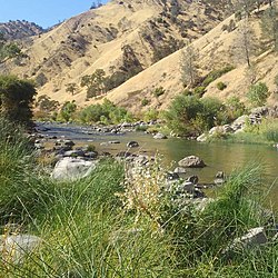
Cache Creek, in a canyon with native chaparral and woodlands habitat vegetation, in Lake County, northern California
438:. Cache Creek provides white-water rafting, both in the spring when it is flooded, and through the summer using the
1794:
1777:
1712:
1616:
1164:
942:
824:
and innertubing which are popular in the summer using the water released from the dams for downstream agriculture.
790:
774:
745:
Aerial view of tributary Davis Creek, Davis Creek Dam (owned by Homestake Mining), and Homestake Mining operation,
575:
528:
427:
381:
329:
1380:
Domagalski, Joseph L.; Alpers, Charles N.; Slotton, Darell G.; Suchanek, Thomas H.; Ayers, Shaun M. (2004-07-05).
1862:
1799:
1789:
1762:
1757:
1707:
786:
696:
587:
558:
546:
443:
431:
373:
349:
75:
519:
1917:
1902:
1767:
1747:
789:, on which vehicles are prohibited but hiking, primitive camping, and hunting are allowed. The North Fork and
927:
913:
770:
707:
684:
554:
542:
535:
459:
377:
369:
353:
345:
98:
79:
71:
806:
802:
325:
1350:
1065:
111:
1198:
1393:
1250:
1104:
625:
416:
177:
1337:"Summary and Synthesis of Mercury Studies in the Cache Creek Watershed, California, 2000-01". 2004.
1052:"Summary and Synthesis of Mercury Studies in the Cache Creek Watershed, California, 2000-01". 2004.
754:
404:
721:, diverts water for distribution throughout Yolo County using a 175-mile (280 km) network of
609:, diverts water for distribution throughout Yolo County using a 175-mile (280 km) network of
538:(for which it is the outlet), flowing east to the dam which now controls the level of Clear Lake.
1425:
595:
475:
1821:
1444:
1417:
1409:
1120:
718:
621:
606:
503:
released an advisory regarding eating fish caught from this creek based on the mercury level.
408:
392:
1382:"Mercury and methylmercury concentrations and loads in the Cache Creek watershed, California"
761:, to infiltrate water systems and make its way into Cache Creek . Through a process known as
683:
The Cache Creek Dam on the South Fork of Cache Creek, five miles (8 km) downstream from
1879:
1847:
1678:
1401:
1338:
1112:
1053:
832:
828:
801:. The ruggedness of the area tends to ensure its isolation from human activity. In 2006 the
637:
496:
464:
420:
1842:
1830:
1727:
1363:
1078:
974:
946:
864:
860:
810:
762:
495:
confirmed that Cache Creek was a contributor to the increase of mercury levels within the
691:
plant. The stream has a relatively small capacity, less than a quarter of the amount the
1468:
1465:
1397:
1108:
1874:
1852:
1835:
1784:
1580:
958:
852:
753:
From the early 1800s to much of the 1900s, mining for elemental mercury, also known as
583:
511:
412:
1116:
928:
U.S. Geological Survey Geographic Names Information System: Cache Creek Settling Basin
1942:
1742:
1692:
1223:
856:
730:
714:, but a 3.3 MW hydroelectric plant was built to take advantage of the falling water.
688:
51:
1405:
938:
U.S. Geological Survey. National Hydrography Dataset high-resolution flowline data.
1907:
1884:
1869:
1857:
1722:
1429:
1139:
1035:
1009:
837:
599:
400:
1894:
1811:
1040:
Trees have been toppled over and are being pushed downstream by the floodwaters.
798:
746:
726:
649:
161:
1927:
1922:
1912:
1772:
711:
572:
before joining the North Fork about 2 miles east of the bridge over Route 20.
568:
Cache Creek runs north-east from the dam, behind Perkins Creek Ridge and over
439:
357:
61:
1413:
1124:
805:
designated 27,245 acres (110 km) of the area as the federally protected
206:
193:
140:
127:
1687:
1421:
467:. Cache Creek was originally known to the Hudson's Bay Company trappers as
395:, diverts water for distribution throughout Yolo County using a network of
32:
628:. If the Sacramento river is not in flood then any overflow runs into the
939:
821:
817:
794:
487:
The creek subsequently broke through, causing severe flooding in Rumsey.
447:
266:
557:. It then flows south along New Long Valley Road, and turns east along
1518:
914:
U.S. Geological Survey Geographic Names Information System: Cache Creek
863:, even if there is enough water. Consequently, there are no longer any
843:
668:
617:
1342:
1057:
648:
in flood, then the overflow from the settling basin is swept into the
848:
758:
341:
1545:
1200:
Floodplain Interrupted: The Story of the Cache Creek Settling Basin
740:
722:
700:
667:
610:
518:
510:
446:
and west of Route 16 is a wildlife preserve, hosting two herds of
396:
1641:
1496:
692:
1195:"Yolo County Flood Control & Water Conservation District"
706:
The Indian Valley dam on the North Fork of Cache Creek forms
1484:"Cache Creek, Bear Creek, and Harley Gulch TMDL for Mercury"
1443:
Nutrition, Center for Food Safety and Applied (2020-02-24).
582:
and runs south through a canyon (joining Sulphur Creek near
372:. It has two main tributaries: North Fork (starting in the
1617:
Yolo County Flood Control & Water Conservation District
1313:. Yolo County Flood Control and Water Conservation District
501:
California Office of Environmental Health Hazard Assessment
1194:
549:
north of Upper Lake. It flows east, where it is joined by
1278:"Capay Diversion Dam is key to Yolo County's water works"
527:
Cache Creek has two main tributaries: North Fork, and
959:
http://www.pa-roots.com/~yolo/maps/locations1.html#C
1893:
1820:
1677:
809:. Cache Creek Conservancy has restored a 130-acre
319:
311:
306:
292:
282:
272:
260:
252:
240:
232:
222:
183:
170:
160:
117:
104:
94:
85:
67:
57:
47:
42:
21:
1594:"Cache Creek Bill Progresses Despite Opposition".
37:Cache Creek, Upper Yolo County section, California
710:. The dam's primary purpose is water storage for
1486:2004. California Environmental Protection Agency
1622:Cache Creek Bioregion Information from UC Davis
1469:Off-Channel Pits Mercury Monitoring Protocols"
1979:Bureau of Land Management areas in California
1653:
534:Cache Creek begins at the south-east end of
474:Cache Creek was temporarily blocked north of
430:and Cache Creek run in a scenic canyon along
8:
923:
921:
1577:Sacramento River Portal and Library website
816:Whitewater boating on Cache Creek includes
793:each host a growing population of the rare
656:flood control system, emerging directly at
1660:
1646:
1638:
973:Meltzner, Aron J.; Wald, David J. (2002).
729:—the water of which is used primarily by
485:near the Leonard ranch in Lake county....
434:in Colusa and Yolo county, including the
298:41,400 cu ft/s (1,170 m/s)
1598:(Spring 2005). Friends of the River: 14.
1579:. Lake County Record Bee. Archived from
906:
376:north of Clear Lake, and dammed by the
1359:
1348:
1074:
1063:
458:The name of the water body comes from
419:, the overflow of which runs into the
18:
1479:
1477:
1460:
1458:
1375:
1373:
1332:
1330:
1328:
1090:
1088:
624:, ending in a settling basin east of
515:Aerial view of North Fork Cache Creek
278:533 cu ft/s (15.1 m/s)
244:1,139 sq mi (2,950 km)
7:
1633:Cache Creek Natural Area BLM website
1612:Lake County Water Resources Division
1251:"Conjunctive Use without management"
616:At the end of the Capay Valley near
368:Cache Creek starts at the outlet of
1964:Tributaries of the Sacramento River
1949:Rivers of Colusa County, California
1304:"Capay Diversion Dam Modernisation"
896:Tributaries of the Sacramento River
1969:Geography of the Sacramento Valley
1571:Logson, Terre (October 12, 2005).
813:area downstream in the watershed.
14:
1959:Rivers of Yolo County, California
1954:Rivers of Lake County, California
891:Rivers of Lake County, California
851:has left no suitable habitat for
717:The Capay Diversion Dam, west of
605:The Capay Diversion Dam, west of
391:The Capay Diversion Dam, west of
340:is an 87-mile-long (140 km)
1471:University of California, Davis.
1386:Science of the Total Environment
1032:DIY History Yolo County Archives
1006:DIY History Yolo County Archives
288:0 cu ft/s (0 m/s)
31:
1406:10.1016/j.scitotenv.2004.01.013
442:flow. The entire area south of
423:through a flood control canal.
1974:Wilderness areas of California
185: • coordinates
119: • coordinates
1:
1984:Rivers of Northern California
1546:"Bear Creek into Cache Creek"
1519:"Cache Creek in Capay Valley"
1276:Moyle, Peter (4 March 2011).
1117:10.1016/s0883-2927(01)00068-3
1028:"Earthquake and Flood Damage"
1002:"Earthquake and Flood Damage"
827:Nominally a tributary of the
797:, plus winter populations of
737:Mercury levels at Cache Creek
590:in Colusa and Yolo Counties.
480:1906 San Francisco earthquake
478:by a landslide caused by the
407:, Cache Creek runs east into
86:Physical characteristics
886:List of rivers of California
553:, and is then dammed by the
224: • elevation
1670:California's Central Valley
1224:"WMP District Water Supply"
1138:Admin, OEHHA (2014-12-30).
871:State Wild and Scenic River
811:Cache Creek Nature Preserve
620:Cache Creek runs east into
563:Cache Creek Recreation Area
262: • location
172: • location
106: • location
2000:
1672:watershed (north-to-south)
1445:"Advice about Eating Fish"
561:, which it crosses at the
294: • maximum
284: • minimum
274: • average
166:Cache Creek Settling Basin
1573:"Cache Creek Bill Signed"
1497:"Cache Creek Conservancy"
1165:"Cache Creek Hydrography"
949:, accessed March 10, 2011
787:Bureau of Land Management
547:Mendocino National Forest
541:The North Fork begins in
523:Aerial view of Bear Creek
436:Cache Creek Regional Park
374:Mendocino National Forest
302:
248:
156:
90:
30:
867:species in Cache Creek.
847:spp., as well as gravel
236:87 mi (140 km)
16:Stream in California, US
781:Wildlife and recreation
708:Indian Valley Reservoir
636:and finally enters the
555:Indian Valley Reservoir
378:Indian Valley Reservoir
321: • left
228:30 ft (9.1 m)
1358:Cite journal requires
1171:. USGS. Archived from
1163:National Maps Viewer.
1073:Cite journal requires
807:Cache Creek Wilderness
803:United States Congress
750:
673:
524:
516:
493:U.S. Geological Survey
326:North Fork Cache Creek
207:38.69000°N 121.69167°W
141:38.93611°N 122.64306°W
1627:Trust for Public Land
744:
671:
522:
514:
112:Clearlake, California
1583:on December 1, 2008.
1464:Slotton, D. (2017)."
1282:The Davis Enterprise
1097:Applied Geochemistry
644:. If the Sacramento
460:Hudson's Bay Company
399:. At the end of the
212:38.69000; -121.69167
178:Woodland, California
146:38.93611; -122.64306
1552:. California Creeks
1525:. California Creeks
1398:2004ScTEn.327..215D
1109:2001ApGC...16.1677D
982:web.gps.caltech.edu
307:Basin features
203: /
137: /
945:2012-03-29 at the
751:
674:
570:The Jams Waterfall
525:
517:
440:agricultural water
1936:
1935:
1822:San Joaquin River
1466:Lower Cache Creek
1343:10.3133/wri034335
1103:(15): 1677–1691.
1058:10.3133/wri034335
654:Sacramento Bypass
622:Sacramento Valley
409:Sacramento Valley
335:
334:
1991:
1880:Chowchilla River
1848:Stanislaus River
1703:Cottonwood Creek
1679:Sacramento River
1662:
1655:
1648:
1639:
1600:
1599:
1591:
1585:
1584:
1568:
1562:
1561:
1559:
1557:
1541:
1535:
1534:
1532:
1530:
1514:
1508:
1507:
1505:
1503:
1493:
1487:
1481:
1472:
1462:
1453:
1452:
1440:
1434:
1433:
1377:
1368:
1367:
1361:
1356:
1354:
1346:
1334:
1323:
1322:
1320:
1318:
1308:
1299:
1293:
1292:
1290:
1288:
1273:
1267:
1266:
1264:
1262:
1246:
1240:
1239:
1237:
1235:
1220:
1214:
1213:
1212:
1210:
1205:
1191:
1185:
1184:
1182:
1180:
1175:on 29 March 2012
1160:
1154:
1153:
1151:
1150:
1135:
1129:
1128:
1092:
1083:
1082:
1076:
1071:
1069:
1061:
1049:
1043:
1042:
1034:. Archived from
1024:
1018:
1017:
1008:. Archived from
998:
992:
991:
989:
988:
979:
970:
964:
956:
950:
940:The National Map
936:
930:
925:
916:
911:
829:Sacramento River
763:bio-accumulation
638:Sacramento River
497:Sacramento River
469:Rivière la Cache
465:Yolo, California
463:present town of
421:Sacramento River
322:
295:
285:
275:
263:
218:
217:
215:
214:
213:
208:
204:
201:
200:
199:
196:
152:
151:
149:
148:
147:
142:
138:
135:
134:
133:
130:
120:
107:
35:
25:Rivière la Cache
19:
1999:
1998:
1994:
1993:
1992:
1990:
1989:
1988:
1939:
1938:
1937:
1932:
1889:
1843:Calaveras River
1831:Mokelumne River
1816:
1728:Big Chico Creek
1673:
1666:
1608:
1603:
1593:
1592:
1588:
1570:
1569:
1565:
1555:
1553:
1544:Tuthill, Bill.
1543:
1542:
1538:
1528:
1526:
1517:Tuthill, Bill.
1516:
1515:
1511:
1501:
1499:
1495:
1494:
1490:
1482:
1475:
1463:
1456:
1442:
1441:
1437:
1379:
1378:
1371:
1357:
1347:
1336:
1335:
1326:
1316:
1314:
1306:
1302:Sabol, George.
1301:
1300:
1296:
1286:
1284:
1275:
1274:
1270:
1260:
1258:
1249:Jenkins, Mimi.
1248:
1247:
1243:
1233:
1231:
1222:
1221:
1217:
1208:
1206:
1203:
1193:
1192:
1188:
1178:
1176:
1162:
1161:
1157:
1148:
1146:
1137:
1136:
1132:
1094:
1093:
1086:
1072:
1062:
1051:
1050:
1046:
1038:on 2018-08-03.
1026:
1025:
1021:
1012:on 2018-08-03.
1000:
999:
995:
986:
984:
977:
972:
971:
967:
957:
953:
947:Wayback Machine
937:
933:
926:
919:
912:
908:
904:
882:
873:
865:anadromous fish
833:invasive plants
783:
739:
666:
634:Prospect Slough
632:, continues as
509:
456:
366:
320:
293:
283:
273:
261:
225:
211:
209:
205:
202:
197:
194:
192:
190:
189:
186:
173:
145:
143:
139:
136:
131:
128:
126:
124:
123:
118:
105:
38:
26:
23:
17:
12:
11:
5:
1997:
1995:
1987:
1986:
1981:
1976:
1971:
1966:
1961:
1956:
1951:
1941:
1940:
1934:
1933:
1931:
1930:
1925:
1920:
1915:
1910:
1905:
1899:
1897:
1891:
1890:
1888:
1887:
1882:
1877:
1875:Mariposa Creek
1872:
1867:
1866:
1865:
1860:
1853:Tuolumne River
1850:
1845:
1840:
1839:
1838:
1836:Cosumnes River
1827:
1825:
1818:
1817:
1815:
1814:
1809:
1804:
1803:
1802:
1797:
1792:
1785:American River
1782:
1781:
1780:
1775:
1770:
1765:
1760:
1755:
1750:
1740:
1735:
1730:
1725:
1720:
1715:
1710:
1705:
1700:
1695:
1690:
1684:
1682:
1675:
1674:
1667:
1665:
1664:
1657:
1650:
1642:
1636:
1635:
1630:
1624:
1619:
1614:
1607:
1604:
1602:
1601:
1586:
1563:
1536:
1509:
1488:
1473:
1454:
1435:
1392:(1): 215–237.
1369:
1360:|journal=
1324:
1294:
1268:
1255:Masters Thesis
1241:
1215:
1186:
1155:
1130:
1084:
1075:|journal=
1044:
1019:
993:
965:
951:
931:
917:
905:
903:
900:
899:
898:
893:
888:
881:
878:
872:
869:
853:Chinook salmon
782:
779:
738:
735:
697:State Route 53
665:
662:
588:State Route 16
584:Wilbur Springs
559:State Route 20
551:Bartlett Creek
508:
505:
455:
452:
432:State Route 16
413:settling basin
411:, ending in a
365:
362:
333:
332:
323:
317:
316:
313:
309:
308:
304:
303:
300:
299:
296:
290:
289:
286:
280:
279:
276:
270:
269:
264:
258:
257:
254:
250:
249:
246:
245:
242:
238:
237:
234:
230:
229:
226:
223:
220:
219:
187:
184:
181:
180:
174:
171:
168:
167:
164:
158:
157:
154:
153:
121:
115:
114:
108:
102:
101:
96:
92:
91:
88:
87:
83:
82:
69:
65:
64:
59:
55:
54:
49:
45:
44:
40:
39:
36:
28:
27:
24:
15:
13:
10:
9:
6:
4:
3:
2:
1996:
1985:
1982:
1980:
1977:
1975:
1972:
1970:
1967:
1965:
1962:
1960:
1957:
1955:
1952:
1950:
1947:
1946:
1944:
1929:
1926:
1924:
1921:
1919:
1916:
1914:
1911:
1909:
1906:
1904:
1901:
1900:
1898:
1896:
1892:
1886:
1883:
1881:
1878:
1876:
1873:
1871:
1868:
1864:
1861:
1859:
1856:
1855:
1854:
1851:
1849:
1846:
1844:
1841:
1837:
1834:
1833:
1832:
1829:
1828:
1826:
1823:
1819:
1813:
1810:
1808:
1805:
1801:
1798:
1796:
1793:
1791:
1788:
1787:
1786:
1783:
1779:
1776:
1774:
1771:
1769:
1766:
1764:
1761:
1759:
1756:
1754:
1751:
1749:
1746:
1745:
1744:
1743:Feather River
1741:
1739:
1736:
1734:
1731:
1729:
1726:
1724:
1721:
1719:
1716:
1714:
1711:
1709:
1706:
1704:
1701:
1699:
1696:
1694:
1693:McCloud River
1691:
1689:
1686:
1685:
1683:
1680:
1676:
1671:
1663:
1658:
1656:
1651:
1649:
1644:
1643:
1640:
1634:
1631:
1628:
1625:
1623:
1620:
1618:
1615:
1613:
1610:
1609:
1605:
1597:
1590:
1587:
1582:
1578:
1574:
1567:
1564:
1551:
1547:
1540:
1537:
1524:
1520:
1513:
1510:
1498:
1492:
1489:
1485:
1480:
1478:
1474:
1470:
1467:
1461:
1459:
1455:
1450:
1446:
1439:
1436:
1431:
1427:
1423:
1419:
1415:
1411:
1407:
1403:
1399:
1395:
1391:
1387:
1383:
1376:
1374:
1370:
1365:
1352:
1344:
1340:
1333:
1331:
1329:
1325:
1312:
1305:
1298:
1295:
1283:
1279:
1272:
1269:
1256:
1252:
1245:
1242:
1230:. Yolo County
1229:
1225:
1219:
1216:
1202:
1201:
1196:
1190:
1187:
1174:
1170:
1166:
1159:
1156:
1145:
1141:
1140:"Cache Creek"
1134:
1131:
1126:
1122:
1118:
1114:
1110:
1106:
1102:
1098:
1091:
1089:
1085:
1080:
1067:
1059:
1055:
1048:
1045:
1041:
1037:
1033:
1029:
1023:
1020:
1016:
1011:
1007:
1003:
997:
994:
983:
976:
969:
966:
963:
960:
955:
952:
948:
944:
941:
935:
932:
929:
924:
922:
918:
915:
910:
907:
901:
897:
894:
892:
889:
887:
884:
883:
879:
877:
870:
868:
866:
862:
858:
854:
850:
846:
845:
840:
839:
834:
830:
825:
823:
819:
814:
812:
808:
804:
800:
796:
792:
788:
780:
778:
776:
772:
766:
764:
760:
756:
748:
743:
736:
734:
732:
731:Solano County
728:
724:
720:
715:
713:
709:
704:
702:
698:
694:
690:
689:hydroelectric
686:
681:
677:
670:
663:
661:
659:
655:
651:
647:
643:
639:
635:
631:
627:
623:
619:
614:
612:
608:
603:
601:
597:
591:
589:
585:
581:
577:
573:
571:
566:
564:
560:
556:
552:
548:
544:
539:
537:
532:
530:
521:
513:
506:
504:
502:
498:
494:
488:
486:
481:
477:
472:
470:
466:
461:
453:
451:
449:
445:
441:
437:
433:
429:
424:
422:
418:
414:
410:
406:
402:
398:
394:
389:
387:
384:(starting in
383:
379:
375:
371:
363:
361:
359:
355:
351:
347:
343:
339:
331:
327:
324:
318:
314:
310:
305:
301:
297:
291:
287:
281:
277:
271:
268:
265:
259:
255:
251:
247:
243:
239:
235:
231:
227:
221:
216:
188:
182:
179:
175:
169:
165:
163:
159:
155:
150:
122:
116:
113:
110:southwest of
109:
103:
100:
97:
93:
89:
84:
81:
77:
76:Colusa County
73:
70:
66:
63:
60:
56:
53:
52:United States
50:
46:
41:
34:
29:
20:
1908:Kaweah River
1895:Tulare Basin
1885:Fresno River
1870:Merced River
1863:Cherry Creek
1858:Clavey River
1806:
1723:Thomes Creek
1708:Battle Creek
1595:
1589:
1581:the original
1576:
1566:
1554:. Retrieved
1549:
1539:
1527:. Retrieved
1522:
1512:
1500:. Retrieved
1491:
1448:
1438:
1389:
1385:
1351:cite journal
1315:. Retrieved
1310:
1297:
1285:. Retrieved
1281:
1271:
1259:. Retrieved
1254:
1244:
1232:. Retrieved
1227:
1218:
1207:, retrieved
1199:
1189:
1177:. Retrieved
1173:the original
1168:
1158:
1147:. Retrieved
1143:
1133:
1100:
1096:
1066:cite journal
1047:
1039:
1036:the original
1031:
1022:
1013:
1010:the original
1005:
996:
985:. Retrieved
981:
968:
962:pa-roots.com
961:
954:
934:
909:
874:
842:
838:Arundo donax
836:
826:
815:
784:
767:
752:
716:
705:
682:
678:
675:
658:Cache Slough
657:
653:
645:
642:Cache Slough
641:
633:
629:
615:
604:
600:Capay Valley
592:
574:
567:
562:
540:
533:
526:
489:
483:
473:
468:
457:
435:
425:
401:Capay Valley
390:
367:
337:
336:
1918:White River
1903:Kings River
1812:Putah Creek
1807:Cache Creek
1795:Middle Fork
1763:Middle Fork
1758:West Branch
1753:East Branch
1738:Butte Creek
1733:Stony Creek
1556:22 February
1529:22 February
1317:16 February
1287:16 February
1261:15 February
1234:10 February
1179:22 February
820:, rafting,
799:bald eagles
755:quicksilver
747:Yolo County
727:Putah Creek
650:Yolo Bypass
580:Bear Valley
543:Lake County
386:Bear Valley
338:Cache Creek
312:Tributaries
210: /
198:121°41′30″W
144: /
132:122°38′35″W
80:Lake County
72:Yolo County
22:Cache Creek
1943:Categories
1928:Kern River
1923:Poso Creek
1913:Tule River
1800:South Fork
1790:North Fork
1778:Bear River
1773:Yuba River
1768:South Fork
1748:North Fork
1718:Deer Creek
1713:Mill Creek
1668:Rivers of
1606:References
1596:Headwaters
1502:3 February
1257:. UC Davis
1149:2018-06-11
987:2023-07-21
835:, such as
791:Bear Creek
775:Bear Creek
771:Clear Lake
712:irrigation
685:Clear Lake
630:Tule Canal
578:starts in
576:Bear Creek
536:Clear Lake
529:Bear Creek
428:Bear Creek
382:Bear Creek
370:Clear Lake
358:California
356:counties,
330:Bear Creek
241:Basin size
195:38°41′24″N
129:38°56′10″N
99:Clear Lake
62:California
1824:watershed
1698:Cow Creek
1688:Pit River
1681:watershed
1414:0048-9697
1125:0883-2927
857:steelhead
773:outflow,
759:retorting
664:Hydrology
507:Geography
253:Discharge
1422:15172583
1015:picture.
943:Archived
880:See also
822:canoeing
818:kayaking
795:tule elk
701:flooding
626:Woodland
482: :
448:Tule Elk
444:Route 20
417:Woodland
415:east of
267:Yolo, CA
176:east of
43:Location
1430:6816647
1394:Bibcode
1228:Article
1209:23 June
1105:Bibcode
844:Tamarix
749:Road 40
618:Esparto
545:in the
454:History
405:Esparto
403:, near
380:); and
48:Country
1428:
1420:
1412:
1311:Report
1123:
849:mining
723:canals
611:canals
596:Rumsey
476:Rumsey
397:canals
364:Course
350:Colusa
342:stream
315:
256:
233:Length
95:Source
68:Region
1629:(PDF)
1550:Guide
1523:Guide
1426:S2CID
1307:(PDF)
1204:(PDF)
1144:OEHHA
978:(PDF)
902:Notes
861:spawn
719:Capay
652:and
607:Capay
393:Capay
162:Mouth
58:State
1558:2014
1531:2014
1504:2013
1418:PMID
1410:ISSN
1364:help
1319:2014
1289:2014
1263:2014
1236:2014
1211:2014
1181:2014
1121:ISSN
1079:help
855:and
841:and
354:Yolo
352:and
346:Lake
1449:FDA
1402:doi
1390:327
1339:doi
1169:Map
1113:doi
1054:doi
859:to
693:dam
640:at
598:in
388:).
344:in
1945::
1575:.
1548:.
1521:.
1476:^
1457:^
1447:.
1424:.
1416:.
1408:.
1400:.
1388:.
1384:.
1372:^
1355::
1353:}}
1349:{{
1327:^
1309:.
1280:.
1253:.
1226:.
1197:,
1167:.
1142:.
1119:.
1111:.
1101:16
1099:.
1087:^
1070::
1068:}}
1064:{{
1030:.
1004:.
980:.
920:^
660:.
646:is
613:.
602:.
565:.
531:.
471:.
450:.
360:.
348:,
328:,
78:,
74:,
1661:e
1654:t
1647:v
1560:.
1533:.
1506:.
1451:.
1432:.
1404::
1396::
1366:)
1362:(
1345:.
1341::
1321:.
1291:.
1265:.
1238:.
1183:.
1152:.
1127:.
1115::
1107::
1081:)
1077:(
1060:.
1056::
990:.
Text is available under the Creative Commons Attribution-ShareAlike License. Additional terms may apply.