682:
303:
240:
187:
80:
247:
39:
49:
257:
842:
423:
380:
38:
410:
all gone. The original bronze marker were stolen by thieves and is now replaced by the locals with a white board with the original inscriptions. The roof of the keeper's house and utility rooms have since collapsed. The lighthouse is closed to visitors due to its dilapidated state.
405:
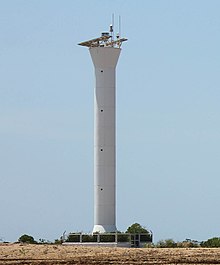
with a new solar-powered tower located next to the previous tower under its
Maritime Safety Improvement Project. After the replacement, the lighthouse was abandoned and left open for thieves and vandals. The expensive first-order lens were vandalized with the large front
392:
The original light, visible for 25 nautical miles (29 mi; 46 km), was shown from a 67-foot (20 m) high square tower on the west angle of the station. It is visible around the entire horizon except where obscured by Lubang and Ambil
Islands.
364:
The lighthouse of Cabra was the first completed during Spain's revitalized program of lighthouse construction in the
Philippines. Construction was started on May 3, 1885, and it was first lit on March 1, 1889. It was also the first of the five
871:
662:
876:
624:
655:
484:
458:
373:
866:
648:
861:
671:
436:
756:
246:
515:
Noche, Manuel M., "Lonely
Sentinels of the Sea, The Spanish Lighthouses in the Philippines", p.55. U.S.T. Publishing House, 2005.
681:
621:
94:
776:
87:
826:
816:
801:
796:
70:
831:
616:
766:
746:
706:
751:
736:
726:
701:
791:
696:
771:
741:
716:
811:
806:
781:
721:
402:
821:
538:
48:
634:
562:
353:
302:
219:
761:
691:
186:
428:
337:
74:
841:
256:
786:
24:
711:
574:
550:
525:
628:
588:
345:
379:
79:
526:"Old vs new : Faro de Punta de Isla Cabra standing beside its modern counterpart"
855:
333:
239:
506:. Amateur Radio Lighthouse Society's World List of Lights. Retrieved on 2010-06-06.
407:
329:
66:
640:
369:
366:
341:
20:
476:
503:
418:
349:
325:
450:
109:
96:
378:
644:
348:
were welcomed by the Cabra Light and directed either towards
344:. International vessels entering the Philippines from
16:
Historic lighthouse in
Occidental Mindoro, Philippines
372:built by the Spaniards in the latter part of their
295:
287:
279:
271:
263:
218:
210:
202:
194:
179:
174:
162:
154:
146:
138:
130:
125:
86:
62:
872:Spanish colonial infrastructure in the Philippines
451:"Lighthouses of the Philippines: Southwest Luzon"
356:, one of busiest sea routes of the Philippines.
877:Buildings and structures in Occidental Mindoro
656:
575:"Derelict, Abandoned. But still breathtaking"
8:
551:"Isla de Cabra Lighthouse (Original marker)"
401:The original lighthouse was replaced by the
33:
539:"Old lighthouse, Cabra Island, Philippines"
485:University of North Carolina at Chapel Hill
459:University of North Carolina at Chapel Hill
663:
649:
641:
301:
255:
238:
214:25 nautical miles (29 mi; 46 km)
185:
78:
47:
32:
477:"Lighthouses of the Philippines: Palawan"
352:or the center of the archipelago through
283:cylindrical tower with balcony and beacon
467:
622:Cabra Island Light on Lighthouse Depot
437:List of lighthouses in the Philippines
158:square tower with balcony and lantern
7:
383:Cabra Island Lighthouse, March 2014
577:. Flickr. Retrieved on 2011-11-01.
553:. Flickr. Retrieved on 2011-11-01.
541:. Flickr. Retrieved on 2011-11-01.
528:. Flickr. Retrieved on 2011-11-01.
14:
840:
680:
617:Maritime Safety Services Command
421:
245:
37:
637:page from Lubang Island Website
332:, the north-westernmost of the
867:Lighthouses in the Philippines
672:Lighthouses in the Philippines
1:
862:Lighthouses completed in 1889
587:Boniol, Leti (May 8, 2014).
893:
524:de Lara, MJ (2008-01-10).
18:
838:
687:
678:
563:"Cabra Island Lighthouse"
314:
310:
254:
236:
232:
228:
170:
58:
46:
481:The Lighthouse Directory
455:The Lighthouse Directory
206:first-order Fresnel lens
150:20.5 metres (67 ft)
635:Cabra Island Lighthouse
334:Lubang group of islands
322:Cabra Island Lighthouse
198:66 metres (217 ft)
34:Cabra Island lighthouse
537:Neikirk (2009-02-19).
403:Philippine Coast Guard
384:
275:20 metres (66 ft)
53:The lighthouse in 1903
23:'s Cabras Island, see
19:For the lighthouse in
827:Siete Pecados Islands
817:San Bernardino Island
589:"Laid-back in Lubang"
382:
376:of the archipelago.
354:Verde Island Passage
110:13.8886°N 120.0233°E
762:Capitancillo Island
142:brick masonry tower
106: /
43:
627:2011-06-14 at the
429:Philippines portal
385:
338:Occidental Mindoro
237:Modern light
183:1 March 1889
75:Occidental Mindoro
849:
848:
832:Tanguingui Island
777:Corregidor Island
397:Current condition
318:
317:
299:solar power
115:13.8886; 120.0233
25:Isla Cabras Light
884:
844:
787:Jintotolo Island
684:
665:
658:
651:
642:
604:
603:
601:
599:
584:
578:
572:
566:
560:
554:
548:
542:
535:
529:
522:
516:
513:
507:
504:Isla Cabra Light
501:
495:
494:
492:
491:
472:
462:
431:
426:
425:
424:
306:
305:
259:
250:
249:
242:
190:
189:
121:
120:
118:
117:
116:
111:
107:
104:
103:
102:
99:
82:
51:
44:
42:
41:
892:
891:
887:
886:
885:
883:
882:
881:
852:
851:
850:
845:
836:
802:Maniguin Island
797:Malabrigo Point
685:
674:
669:
629:Wayback Machine
613:
608:
607:
597:
595:
586:
585:
581:
573:
569:
561:
557:
549:
545:
536:
532:
523:
519:
514:
510:
502:
498:
489:
487:
475:Rowlett, Russ.
474:
473:
469:
449:Rowlett, Russ.
448:
445:
427:
422:
420:
417:
399:
390:
362:
346:South China Sea
300:
243:
184:
114:
112:
108:
105:
100:
97:
95:
93:
92:
77:, Philippines
54:
35:
31:
28:
17:
12:
11:
5:
890:
888:
880:
879:
874:
869:
864:
854:
853:
847:
846:
839:
837:
835:
834:
829:
824:
819:
814:
809:
804:
799:
794:
789:
784:
779:
774:
769:
767:Capones Island
764:
759:
754:
749:
744:
739:
734:
729:
727:Caballo Island
724:
719:
714:
709:
707:Bagatao Island
704:
699:
694:
688:
686:
679:
676:
675:
670:
668:
667:
660:
653:
645:
639:
638:
631:
619:
612:
611:External links
609:
606:
605:
579:
567:
555:
543:
530:
517:
508:
496:
466:
465:
464:
463:
444:
441:
440:
439:
433:
432:
416:
413:
408:Fresnel lenses
398:
395:
389:
386:
361:
358:
324:is a historic
316:
315:
312:
311:
308:
307:
297:
293:
292:
289:
285:
284:
281:
277:
276:
273:
269:
268:
267:concrete tower
265:
261:
260:
252:
251:
234:
233:
230:
229:
226:
225:
222:
220:Characteristic
216:
215:
212:
208:
207:
204:
200:
199:
196:
192:
191:
181:
177:
176:
172:
171:
168:
167:
164:
160:
159:
156:
152:
151:
148:
144:
143:
140:
136:
135:
132:
128:
127:
123:
122:
90:
84:
83:
64:
60:
59:
56:
55:
52:
29:
15:
13:
10:
9:
6:
4:
3:
2:
889:
878:
875:
873:
870:
868:
865:
863:
860:
859:
857:
843:
833:
830:
828:
825:
823:
822:Sibago Island
820:
818:
815:
813:
810:
808:
805:
803:
800:
798:
795:
793:
792:Lusaran Point
790:
788:
785:
783:
780:
778:
775:
773:
770:
768:
765:
763:
760:
758:
757:Cape Santiago
755:
753:
752:Cape Melville
750:
748:
745:
743:
740:
738:
737:Cape Bojeador
735:
733:
730:
728:
725:
723:
720:
718:
715:
713:
710:
708:
705:
703:
702:Bagacay Point
700:
698:
695:
693:
690:
689:
683:
677:
673:
666:
661:
659:
654:
652:
647:
646:
643:
636:
632:
630:
626:
623:
620:
618:
615:
614:
610:
594:
593:Inquirer News
590:
583:
580:
576:
571:
568:
564:
559:
556:
552:
547:
544:
540:
534:
531:
527:
521:
518:
512:
509:
505:
500:
497:
486:
482:
478:
471:
468:
460:
456:
452:
447:
446:
442:
438:
435:
434:
430:
419:
414:
412:
409:
404:
396:
394:
387:
381:
377:
375:
371:
368:
359:
357:
355:
351:
347:
343:
339:
335:
331:
327:
323:
313:
309:
304:
298:
294:
290:
286:
282:
278:
274:
270:
266:
262:
258:
253:
248:
241:
235:
231:
227:
223:
221:
217:
213:
209:
205:
201:
197:
193:
188:
182:
178:
173:
169:
165:
161:
157:
153:
149:
145:
141:
137:
133:
129:
124:
119:
91:
89:
85:
81:
76:
72:
68:
65:
61:
57:
50:
45:
40:
26:
22:
772:Capul Island
742:Cape Bolinao
732:Cabra Island
731:
717:Batag Island
697:Apunan Point
596:. Retrieved
592:
582:
570:
558:
546:
533:
520:
511:
499:
488:. Retrieved
480:
470:
454:
400:
391:
374:colonization
363:
330:Cabra Island
321:
319:
296:Power source
264:Construction
195:Focal height
139:Construction
67:Cabra Island
807:Pasig River
782:Gorda Point
747:Cape Engaño
722:Bugui Point
388:Description
370:lighthouses
367:first-order
342:Philippines
291:white tower
166:white tower
131:Constructed
113: /
101:120°01′24″E
88:Coordinates
21:Puerto Rico
856:Categories
812:Poro Point
490:2016-03-11
443:References
350:Manila Bay
326:lighthouse
98:13°53′19″N
30:Lighthouse
328:built on
180:First lit
692:Apo Reef
625:Archived
415:See also
288:Markings
224:Oc W 5s.
163:Markings
63:Location
598:May 11,
360:History
272:Height
147:Height
71:Lubang
712:Basco
280:Shape
244:
211:Range
175:Light
155:Shape
126:Tower
36:
600:2017
320:The
203:Lens
134:1889
336:in
858::
633:A
591:.
483:.
479:.
457:.
453:.
340:,
73:,
69:,
664:e
657:t
650:v
602:.
565:.
493:.
461:.
27:.
Text is available under the Creative Commons Attribution-ShareAlike License. Additional terms may apply.