115:
31:
162:
122:
155:
222:, 2 kilometers to the east while Edinburgh's southern suburbs start about a kilometer to the north. The nearest hills are Allermuir Hill to the west and Woodhouselee Hill to the south. The Swanston Burn and Lothian Burn rise on the northern slopes while the Boghall Burn receives water from the southern slopes. Their waters meet in the Burdiehouse Burn and, eventually, as the Brunstane Burn, drain into the
248:
The remains of a hill fort can be found on a rocky outcrop almost ten meters high on the east flank. Located in a well-defended position, the facility was surrounded by at least one wall. There was a rampart on the west side. The fort is classified as a
Scheduled Monument.
210:
range of
Scotland. Standing at 478 m, it is at the northeast end of the approximately 25 km (16 mi) long chain of hills on the border between the council areas of the
114:
233:
On the crest of the hill are the scattered remains of a cairn now consisting of small stones, 16 meters in diameter and 1.5 meter high. The cairn is protected as a
430:
154:
70:
211:
134:
395:
377:
353:
335:
311:
63:
425:
30:
53:
227:
297:
404:
362:
320:
234:
381:
339:
223:
207:
195:
188:
419:
245:
A flint arrowhead was discovered on the western flank of
Caerketton Hill in 1970.
272:
215:
138:
85:
72:
219:
252:
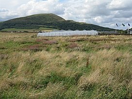
A dry ski run was installed on the north flank of the
Caerketton Hill.
399:
43:
357:
315:
400:"Edinburgh, Hillend Artificial Ski Slopes (149265)"
187:
101:
62:
52:
42:
37:
23:
144:Show map of the City of Edinburgh council area
8:
267:
265:
20:
261:
161:
121:
16:Hill in City of Edinburgh, Scotland, UK
7:
340:"Caerketton Craigs, cairn (SM4118)"
298:"Eintrag im Gazetteer for Scotland"
14:
431:Mountains and hills of Midlothian
273:"Caerketton Hill, United Kingdom"
382:"Caerketton Hill, fort (SM4067)"
160:
153:
120:
113:
29:
135:City of Edinburgh council area
1:
396:Historic Environment Scotland
378:Historic Environment Scotland
354:Historic Environment Scotland
336:Historic Environment Scotland
312:Historic Environment Scotland
447:
174:Caerketton Hill (Scotland)
48:478 m (1,568 ft)
316:"Caerketton Hill (51764)"
300:. Gazetteer for Scotland.
106:
28:
58:63 m (207 ft)
218:. The nearest town is
228:Eastfield, Edinburgh
177:Show map of Scotland
86:55.88305°N 3.22141°W
82: /
426:Hills of Edinburgh
235:scheduled monument
91:55.88305; -3.22141
38:Highest point
358:"Hillend (51763)"
212:City of Edinburgh
206:is a hill in the
201:
200:
438:
410:
409:
392:
386:
385:
374:
368:
367:
350:
344:
343:
332:
326:
325:
308:
302:
301:
294:
288:
287:
285:
283:
269:
191:
178:
164:
163:
157:
145:
124:
123:
117:
97:
96:
94:
93:
92:
87:
83:
80:
79:
78:
75:
33:
21:
446:
445:
441:
440:
439:
437:
436:
435:
416:
415:
414:
413:
394:
393:
389:
376:
375:
371:
352:
351:
347:
334:
333:
329:
310:
309:
305:
296:
295:
291:
281:
279:
271:
270:
263:
258:
243:
204:Caerketton Hill
189:
183:
182:
181:
180:
179:
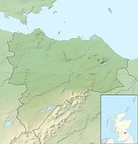
176:
175:
172:
171:
170:
169:
168:Caerketton Hill
165:
148:
147:
146:
143:
142:
132:
131:
130:
129:
128:Caerketton Hill
125:
90:
88:
84:
81:
76:
73:
71:
69:
68:
24:Caerketton Hill
17:
12:
11:
5:
444:
442:
434:
433:
428:
418:
417:
412:
411:
387:
369:
345:
327:
303:
289:
277:Peakbagger.com
260:
259:
257:
254:
242:
239:
224:Firth of Forth
208:Pentland Hills
199:
198:
196:Pentland Hills
193:
185:
184:
173:
167:
166:
159:
158:
152:
151:
150:
149:
133:
127:
126:
119:
118:
112:
111:
110:
109:
108:
107:
104:
103:
99:
98:
66:
60:
59:
56:
50:
49:
46:
40:
39:
35:
34:
26:
25:
15:
13:
10:
9:
6:
4:
3:
2:
443:
432:
429:
427:
424:
423:
421:
407:
406:
401:
397:
391:
388:
383:
379:
373:
370:
365:
364:
359:
355:
349:
346:
341:
337:
331:
328:
323:
322:
317:
313:
307:
304:
299:
293:
290:
278:
274:
268:
266:
262:
255:
253:
250:
246:
240:
238:
236:
231:
229:
225:
221:
217:
213:
209:
205:
197:
194:
192:
186:
156:
140:
136:
116:
105:
100:
95:
67:
65:
61:
57:
55:
51:
47:
45:
41:
36:
32:
27:
22:
19:
403:
390:
372:
361:
348:
330:
319:
306:
292:
280:. Retrieved
276:
251:
247:
244:
241:Surroundings
232:
203:
202:
190:Parent range
18:
89: /
64:Coordinates
420:Categories
282:5 February
256:References
216:Midlothian
141:, Scotland
139:Midlothian
74:55°52′59″N
54:Prominence
102:Geography
77:3°13′17″W
44:Elevation
220:Loanhead
405:Canmore
363:Canmore
321:Canmore
284:2023
214:and
137:and
226:at
422::
402:.
398:.
380:.
360:.
356:.
338:.
318:.
314:.
275:.
264:^
237:.
230:.
408:.
384:.
366:.
342:.
324:.
286:.
Text is available under the Creative Commons Attribution-ShareAlike License. Additional terms may apply.