34:
409:. In different parts of the country, these were terms for the area of land that a team of eight oxen could plough in a single season and are equivalent to 120 acres (49 hectares); this was the amount of land that was considered to be sufficient to support a single family. By 1086, the hide had become a unit of tax assessment rather than an actual land area; a hide was the amount of land that could be assessed as £1 for tax purposes. The survey records that there was nine ploughlands at Caldecote in 1086 and that there was the capacity for a further five ploughlands. There was 40 acres (16 hectares) of meadows and 15 acres (6 hectares) of woodland at Caldecote.
50:
57:
229:
416:
and was a type of land-tax based on the hide or ploughland. It was originally a way of collecting a tribute to pay off the Danes when they attacked
England, and was only levied when necessary. Following the Norman Conquest, the geld was used to raise money for the King and to pay for continental
398:
Caldecote. There is no consensus about the average size of a household at that time; estimates range from 3.5 to 5.0 people per household. Using these figures, an estimate of the population of
Caldecote in 1086 is in the range of 42 and 60 people. There was no church mentioned at Caldecote.
397:
in
Huntingdonshire. In 1086 there were two manors at Caldecote; the annual rent paid to the lords of the manors in 1066 had been £4 and the rent had increased to £5 in 1086. The Domesday Book does not explicitly detail the population of a place but it records that there was 12 households at
487:
which has administration buildings in
Cambridge. The county council provides county-wide services such as major road infrastructure, fire and rescue, education, social services, libraries and heritage services. Cambridgeshire County Council consists of 69 councillors representing 60
421:
of value would be levied on the land holder. While this was typically two shillings in the pound the amount did vary; for example, in 1084 it was as high as six shillings in the pound. For the manors at
Caldecote the total tax assessed was five geld.
373:
ordered that a survey should be carried out across his kingdom to discover who owned which parts and what it was worth. The survey took place in 1086 and the results were recorded in what, since the 12th century, has become known as the
386:; and, for each manor, there is a summary of the resources of the manor, the amount of annual rent that was collected by the lord of the manor both in 1066 and in 1086, together with the taxable value.
500:
133:
88:
1005:
1082:
253:
472:, and provides services such as building regulations, local planning, environmental health, leisure and tourism. Caldecote is a part of the district ward of
477:
295:
215:
49:
508:
246:
33:
1038:
241:
417:
wars; by 1130, the geld was being collected annually. Having determined the value of a manor's land and other assets, a tax of so many
1077:
716:
765:
740:
666:
258:
711:
686:
457:
287:
277:
946:
889:
818:
203:
169:
1013:
464:
of
Cambridgeshire and has its headquarters in Huntingdon. Huntingdonshire District Council has 52 councillors representing 29
484:
81:
537:
356:
842:
476:
and is represented on the district council by one councillor. District councillors serve for four-year terms following
465:
446:
418:
390:
234:
540:. During this time the population was in the range of 23 (the lowest was in 1891) and 70 (the highest was in 1861).
461:
450:
352:
282:
1087:
489:
183:
401:
The
Domesday Book uses a number of units of measure for areas of land that are now unfamiliar terms, such as
516:
394:
442:
370:
362:
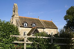
The former Parish Church of St Mary
Magdalene, a Grade II* listed building, is now a private dwelling.
336:
115:
105:
519:). Shailesh Vara has represented the constituency since 2005. The previous member of parliament was
504:
445:
of
Huntingdonshire until 1965. From 1965, the village was part of the new administrative county of
151:
761:
736:
662:
1046:
707:
682:
544:
208:
536:
In the period 1801 to 1901 the population of
Caldecote was recorded every ten years by the
520:
379:
348:
159:
123:
438:. On 1 April 1935 the parish of Caldecote was abolished to form "Denton and Caldecote".
435:
340:
141:
70:
954:
1071:
543:
From 1901, a census was taken every ten years with the exception of 1941 (due to the
512:
375:
344:
332:
97:
791:
469:
402:
383:
864:
406:
310:
297:
193:
343:, England. Caldecote lies approximately 7 miles (11 km) south-west of
413:
638:
The parish of Caldecote was merged with the parish of Denton after 1931.
523:(Conservative) who represented the constituency between 1997 and 2005.
175:
915:
976:
499:
At Westminster Caldecote is in the parliamentary constituency of
712:"Parish Church of St Mary Magdalene (Grade II*) (1215182)"
496:
and is represented on the county council by two councillors.
453:, Caldecote became a part of the county of Cambridgeshire.
843:"Huntingdonshire District Council: Parish Council Details"
865:"Relationships and changes Caldecote AP/CP through time"
434:
which does not have a parish council but has an annual
359:
of England. In 1931 the parish had a population of 27.
483:
For Caldecote the highest tier of local government is
412:
The tax assessment in the Domesday Book was known as
683:"Population statistics Caldecote AP/CP through time"
507:
system of election. Caldecote is represented in the
382:
within a county there is a list of their estates or
252:
240:
228:
214:
202:
192:
182:
168:
150:
132:
114:
96:
80:
26:
503:, and elects one Member of Parliament (MP) by the
492:. Caldecote is part of the electoral division of
389:Caldecote was listed in the Domesday Book in the
1039:"Historic Census figures Cambridgeshire to 2011"
468:. Huntingdonshire District Council collects the
38:Church of St Mary Magdalene, now a private house
1012:. Cambridgeshire County Council. Archived from
890:"Huntingdonshire District Council: Councillors"
630:Historic Census figures Cambridgeshire to 2011
790:Professor J.J.N. Palmer, University of Hull.
658:Peterborough (Market Deeping & Chatteris)
478:elections to Huntingdonshire District Council
8:
1006:"Cambridgeshire County Council: Councillors"
735:. London: Penguin Books. pp. 551–561.
378:. Starting with the king himself, for each
656:Ordnance Survey: Landranger map sheet 142
628:All population census figures from report
23:
941:
939:
937:
430:Caldecote is part of the civil parish of
1045:. Cambridgeshire Insight. Archived from
1033:
1031:
756:Ann Williams; G.H. Martin, eds. (1992).
731:Ann Williams; G.H. Martin, eds. (1992).
549:
1083:Former civil parishes in Cambridgeshire
1000:
998:
884:
882:
760:. London: Penguin Books. p. 1324.
647:
456:The second tier of local government is
223:
191:
167:
79:
30:
785:
783:
781:
779:
777:
758:Domesday Book: A Complete Translation
733:Domesday Book: A Complete Translation
355:of Cambridgeshire as well as being a
251:
239:
227:
213:
201:
181:
149:
131:
113:
7:
819:"Estimating Local Population Sizes"
922:. Huntingdonshire District Council
916:"Huntingdonshire District Council"
896:. Huntingdonshire District Council
867:. A Vision of Britain through Time
845:. Huntingdonshire District Council
792:"Open Domesday: Place – Caldecote"
717:National Heritage List for England
441:Caldecote was in the historic and
16:Village in Cambridgeshire, England
14:
953:. Ordnance Survey. Archived from
56:
1043:www.cambridgeshireinsight.org.uk
687:A Vision of Britain through Time
458:Huntingdonshire District Council
55:
48:
32:
983:. Cambridgeshire County Council
977:"Cambridgeshire County Council"
947:"Ordnance Survey Election Maps"
347:. Caldecote is situated within
661:(Map). Ordnance Survey. 2012.
449:. Then in 1974, following the
1:
817:Goose, Nigel; Hinde, Andrew.
485:Cambridgeshire County Council
419:shillings and pence per pound
622:
620:
618:
616:
614:
612:
610:
607:
604:
601:
447:Huntingdon and Peterborough
82:OS grid reference
21:Human settlement in England
1104:
920:www.huntingdonshire.gov.uk
894:www.huntingdonshire.gov.uk
598:
1078:Hamlets in Cambridgeshire
1010:www.cambridgeshire.gov.uk
981:www.cambridgeshire.gov.uk
552:
501:North West Cambridgeshire
462:non-metropolitan district
451:Local Government Act 1972
353:non-metropolitan district
268:
264:
224:
43:
31:
951:www.ordnancesurvey.co.uk
592:
588:
584:
580:
576:
572:
568:
564:
560:
556:
331:is a village and former
335:, now in the parish of
634:Cambridgeshire Insight
204:Postcode district
443:administrative county
371:William the Conqueror
796:www.opendomesday.org
432:Denton and Caldecote
337:Denton and Caldecote
184:Sovereign state
106:Denton and Caldecote
1052:on 15 February 2016
1016:on 22 February 2016
957:on 20 February 2016
798:. Anna Powell-Smith
505:first past the post
490:electoral divisions
307: /
311:52.4808°N 0.3178°W
216:Dialling code
1050:(xlsx – download)
626:
625:
326:
325:
134:Shire county
1095:
1062:
1061:
1059:
1057:
1051:
1035:
1026:
1025:
1023:
1021:
1002:
993:
992:
990:
988:
973:
967:
966:
964:
962:
943:
932:
931:
929:
927:
912:
906:
905:
903:
901:
886:
877:
876:
874:
872:
861:
855:
854:
852:
850:
839:
833:
832:
830:
828:
823:
814:
808:
807:
805:
803:
787:
772:
771:
753:
747:
746:
728:
722:
721:
708:Historic England
704:
698:
697:
695:
693:
679:
673:
672:
652:
550:
545:Second World War
509:House of Commons
414:geld or danegeld
322:
321:
319:
318:
317:
316:52.4808; -0.3178
312:
308:
305:
304:
303:
300:
274:
178:
92:
91:
69:Location within
59:
58:
52:
36:
24:
1103:
1102:
1098:
1097:
1096:
1094:
1093:
1092:
1088:Huntingdonshire
1068:
1067:
1066:
1065:
1055:
1053:
1049:
1037:
1036:
1029:
1019:
1017:
1004:
1003:
996:
986:
984:
975:
974:
970:
960:
958:
945:
944:
935:
925:
923:
914:
913:
909:
899:
897:
888:
887:
880:
870:
868:
863:
862:
858:
848:
846:
841:
840:
836:
826:
824:
821:
816:
815:
811:
801:
799:
789:
788:
775:
768:
755:
754:
750:
743:
730:
729:
725:
706:
705:
701:
691:
689:
681:
680:
676:
669:
654:
653:
649:
644:
639:
637:
594:
590:
586:
582:
578:
574:
570:
566:
562:
558:
554:
534:
529:
521:Brian Mawhinney
428:
368:
357:historic county
349:Huntingdonshire
315:
313:
309:
306:
301:
298:
296:
294:
293:
292:
272:
259:East of England
174:
164:
146:
128:
124:Huntingdonshire
110:
87:
86:
76:
75:
74:
73:
67:
66:
65:
64:
60:
39:
22:
17:
12:
11:
5:
1101:
1099:
1091:
1090:
1085:
1080:
1070:
1069:
1064:
1063:
1027:
994:
968:
933:
907:
878:
856:
834:
809:
773:
766:
748:
741:
723:
699:
674:
667:
646:
645:
643:
640:
627:
624:
623:
621:
619:
617:
615:
613:
611:
609:
606:
603:
600:
596:
595:
591:
587:
583:
579:
575:
571:
567:
563:
559:
555:
533:
530:
528:
525:
466:district wards
436:parish meeting
427:
424:
367:
364:
341:Cambridgeshire
324:
323:
291:
290:
288:Cambridgeshire
285:
280:
275:
273:List of places
269:
266:
265:
262:
261:
256:
250:
249:
247:Cambridgeshire
244:
238:
237:
235:Cambridgeshire
232:
226:
225:
222:
221:
218:
212:
211:
206:
200:
199:
196:
190:
189:
188:United Kingdom
186:
180:
179:
172:
166:
165:
163:
162:
156:
154:
148:
147:
145:
144:
142:Cambridgeshire
138:
136:
130:
129:
127:
126:
120:
118:
112:
111:
109:
108:
102:
100:
94:
93:
84:
78:
77:
71:Cambridgeshire
68:
62:
61:
54:
53:
47:
46:
45:
44:
41:
40:
37:
29:
28:
20:
15:
13:
10:
9:
6:
4:
3:
2:
1100:
1089:
1086:
1084:
1081:
1079:
1076:
1075:
1073:
1048:
1044:
1040:
1034:
1032:
1028:
1015:
1011:
1007:
1001:
999:
995:
982:
978:
972:
969:
956:
952:
948:
942:
940:
938:
934:
921:
917:
911:
908:
895:
891:
885:
883:
879:
866:
860:
857:
844:
838:
835:
820:
813:
810:
797:
793:
786:
784:
782:
780:
778:
774:
769:
767:0-141-00523-8
763:
759:
752:
749:
744:
742:0-141-00523-8
738:
734:
727:
724:
719:
718:
713:
709:
703:
700:
688:
684:
678:
675:
670:
668:9780319229248
664:
660:
657:
651:
648:
641:
635:
631:
597:
551:
548:
546:
541:
539:
531:
526:
524:
522:
518:
514:
513:Shailesh Vara
510:
506:
502:
497:
495:
491:
486:
481:
479:
475:
471:
467:
463:
459:
454:
452:
448:
444:
439:
437:
433:
425:
423:
420:
415:
410:
408:
404:
399:
396:
392:
387:
385:
381:
377:
376:Domesday Book
372:
365:
363:
360:
358:
354:
350:
346:
342:
338:
334:
330:
320:
289:
286:
284:
281:
279:
276:
271:
270:
267:
263:
260:
257:
255:
248:
245:
243:
236:
233:
231:
219:
217:
210:
207:
205:
197:
195:
187:
185:
177:
173:
171:
161:
158:
157:
155:
153:
143:
140:
139:
137:
135:
125:
122:
121:
119:
117:
107:
104:
103:
101:
99:
95:
90:
85:
83:
72:
51:
42:
35:
25:
19:
1054:. Retrieved
1047:the original
1042:
1018:. Retrieved
1014:the original
1009:
985:. Retrieved
980:
971:
959:. Retrieved
955:the original
950:
924:. Retrieved
919:
910:
898:. Retrieved
893:
869:. Retrieved
859:
847:. Retrieved
837:
825:. Retrieved
812:
800:. Retrieved
795:
757:
751:
732:
726:
715:
702:
690:. Retrieved
677:
659:
655:
650:
633:
629:
542:
535:
517:Conservative
498:
494:Norman Cross
493:
482:
473:
455:
440:
431:
429:
411:
400:
395:Norman Cross
388:
369:
361:
345:Peterborough
333:civil parish
328:
327:
198:Peterborough
98:Civil parish
18:
1056:12 February
1020:15 February
987:23 February
961:23 February
926:23 February
900:23 February
827:23 February
802:25 February
470:council tax
460:which is a
407:ploughlands
351:which is a
314: /
1072:Categories
849:5 February
642:References
599:Caldecote
532:Population
527:Demography
426:Government
380:landholder
299:52°28′51″N
871:8 January
692:8 January
538:UK census
329:Caldecote
302:0°19′04″W
254:Ambulance
194:Post town
63:Caldecote
27:Caldecote
116:District
89:TL143883
474:Stilton
391:Hundred
366:History
283:England
176:England
170:Country
764:
739:
665:
553:Parish
384:manors
230:Police
152:Region
822:(PDF)
593:2011
403:hides
339:, in
220:01733
1058:2016
1022:2016
989:2016
963:2016
928:2016
902:2016
873:2023
851:2016
829:2016
804:2016
762:ISBN
737:ISBN
694:2023
663:ISBN
589:2001
585:1991
581:1981
577:1971
573:1961
569:1951
565:1931
561:1921
557:1911
405:and
242:Fire
160:East
632:by
608:27
605:36
602:28
547:).
511:by
393:of
209:PE7
1074::
1041:.
1030:^
1008:.
997:^
979:.
949:.
936:^
918:.
892:.
881:^
794:.
776:^
714:.
710:.
685:.
480:.
278:UK
1060:.
1024:.
991:.
965:.
930:.
904:.
875:.
853:.
831:.
806:.
770:.
745:.
720:.
696:.
671:.
636:.
515:(
Text is available under the Creative Commons Attribution-ShareAlike License. Additional terms may apply.