435:
420:
2049:
40:
1311:
1209:
1177:
1054:
997:
951:
938:
821:
792:
81:
412:
1266:
1090:
26:
1272:
859:
758:
340:
325:
141:
106:
1317:
1215:
1183:
1096:
1060:
1003:
957:
944:
827:
798:
178:
160:
155:
130:
1440:
404:
692:, based on the alignment that existed at the time, and do not necessarily reflect current mileage. R reflects a realignment in the route since then, M indicates a second realignment, L refers to an overlap due to a correction or change, and T indicates postmiles classified as temporary (
603:. El Portal Drive then splits into a one way loop road to connect the rest of the valley, heading east as Southside Drive on the south side of the river and then looping back west as Northside Drive on the north side of the river.
699:). Segments that remain unconstructed or have been relinquished to local control may be omitted. The numbers reset at county lines; the start and end postmiles in each county are given in the county column.
2484:
642:
The "All-Weather
Highway" (now State Route 140) opened in 1926, ensuring year-long visitation and delivery of supplies under normal conditions. NPS 1989, p. 113. In June 2006, the road between
595:
Inside
Yosemite, state routes are federally maintained and are not included in the state route logs. The highway continues into the park as El Portal Drive, following the Merced River to
1609:
1528:
665:
A small detour opened in August, 2006, with a traffic light system to allow drivers to circumvent the original slide damage area. Plans are underway for construction of a
2530:
1855:
1784:
509:
After exiting
Highway 99, Highway 140 continues through Planada, after which the farmland gives way to grazing land. It is quite dry in the summer due to California's
293:
288:
2535:
2489:
2374:
2525:
689:
298:
2104:
268:
1469:
623:
611:
308:
283:
80:
1719:
1715:
1699:
615:
1661:
581:
2520:
2357:
1848:
303:
278:
2145:
1555:
1636:
1503:
273:
1686:
1068:
2494:
1841:
68:
SR 140 is broken into pieces, and the length does not reflect the overlaps that would be required to make the route continuous.
2323:
619:
2059:
1872:
2479:
2474:
1885:
466:
and the southern portion of
Yosemite would transfer from Highway 99 to Highway 140 at this point. For those coming from
260:
2540:
2297:
1139:
1011:
487:
483:
241:
2389:
2168:
2138:
1277:
1144:
862:
761:
600:
589:
538:
499:
491:
475:
343:
328:
144:
109:
2417:
2384:
2362:
2282:
1421:
1321:
1219:
1187:
1101:
1064:
1007:
965:
961:
831:
802:
727:
659:
655:
604:
554:
451:
380:
237:
181:
167:
163:
133:
434:
2367:
2196:
1998:
1979:
1223:
419:
618:, a network of highways that are considered essential to the country's economy, defense, and mobility by the
2328:
2318:
1444:
1072:
769:
580:. The upper stretch of the Merced River valley below the park, which the highway follows, is designated as
2456:
2421:
2189:
2038:
2023:
2018:
1864:
1473:
1237:
969:
896:
765:
585:
573:
459:
447:
392:
198:
478:
east; then the roads of Road 9, Bliss Road, Sandy Mush Road, and
Plainsburg Road to reach Highway 140 in
2441:
2412:
2272:
2203:
1015:
878:
866:
643:
631:
577:
565:
510:
148:
89:
2451:
2446:
2436:
2431:
2159:
1900:
1191:
1164:
1155:
1122:
654:
buried about 600 feet (180 m) of SR140 between Cedar Lodge and
Briceburg Visitor Center between
647:
627:
561:
550:
534:
467:
424:
388:
185:
85:
1823:
1668:
2407:
2048:
1281:
1111:
914:
874:
779:
695:
685:
542:
503:
495:
479:
384:
113:
2426:
2254:
2175:
1828:
1808:
1382:
1370:
1333:
1329:
1227:
1130:
1126:
973:
923:
870:
835:
651:
514:
455:
376:
171:
572:
valley. The highway then runs alongside the Merced River for about 20 miles (32 km) to the
537:. They become more and more numerous as the elevation increases. As the highway passes through
2499:
2302:
2292:
2033:
1961:
1775:
839:
533:
can be seen as the highway leaves the valley and begins to climb through the foothills of the
443:
2152:
1925:
1910:
1583:
518:
39:
2244:
2239:
2069:
1988:
1935:
1880:
1478:
1349:
596:
522:
463:
2182:
2277:
2229:
2109:
2089:
2079:
2028:
1950:
1905:
546:
526:
471:
411:
2514:
2338:
2099:
2084:
1968:
1895:
673:
364:
217:
1723:
2287:
2249:
2119:
2114:
1890:
569:
482:. (Those going to the northern portion of Yosemite would have instead taken either
1736:
1355:
Continuation beyond SR 41; westbound entrance only accessible via
Northside Drive
2234:
2013:
2008:
1993:
1920:
1818:
1325:
560:
A ponderosa pine forest borders the highway on both sides as it passes through
458:, which it overlaps for a few miles. Travelers coming from most regions of the
2094:
2074:
2003:
1955:
1915:
372:
368:
227:
1813:
442:
Heading east from I-5, the highway passes
Gustine; it then jogs to cross the
2224:
1974:
1945:
1393:
666:
403:
25:
1824:
Acrobat US Forest
Service file containing a map of the slide, (June 2006).
2333:
1833:
530:
428:
56:
599:. The road intersects with Big Oak Flat Road, providing a connection to
1783:
1563:(Map). Scale not given. Washington, DC: Federal Highway Administration
1582:
Natzke, Stefan; Neathery, Mike & Adderly, Kevin (June 20, 2012).
1472:. Sacramento: California Department of Transportation. Archived from
607:/Wawona Road intersects with Southside Drive just east of the split.
1703:
978:
Interchange; west end of SR 99 / SR 59 overlap; SR 99 south exit 188
1637:"Officially Designated State Scenic Highways and Historic Parkways"
1504:"Officially Designated State Scenic Highways and Historic Parkways"
1205:
1173:
1050:
993:
934:
817:
788:
433:
418:
410:
402:
446:. It roughly marks the southern edge of the farmable land around
1837:
1798:
1347:
1307:
1294:
1253:
Arch Rock
Entrance Station; park fee or pass required for entry
1030:
2485:
National Register of Historic Places in Yosemite National Park
1829:
Current Conditions - Ferguson Rock Slide, Chronology of Events
1077:
Interchange; east end of SR 99 overlap; SR 99 north exit 186B
2047:
1793:
1360:
1.000 mi = 1.609 km; 1.000 km = 0.621 mi
1252:
1803:
1420:
Indicates that the postmile represents the distance along
669:
through the slide area to restore the original alignment.
568:, the roadway follows a steep, winding grade down to the
696:
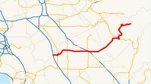
California postmile § Official postmile definitions
513:, and the dry grass gives the landscape a golden color.
1771:
1766:
1635:
California Department of Transportation (August 2019).
1502:
California Department of Transportation (August 2019).
1689:. Sacramento: California Department of Transportation.
1616:. Sacramento: California Office of Legislative Counsel
1535:. Sacramento: California Office of Legislative Counsel
1245:
East end of state maintenance at western park boundary
1231:
1203:
1195:
1171:
1076:
1048:
1019:
990:
977:
932:
843:
815:
807:
786:
375:, 102 miles (164 km) in length. It begins in the
1685:
California Department of Transportation (July 2007).
1642:. Sacramento: California Department of Transportation
1509:. Sacramento: California Department of Transportation
2465:
2398:
2347:
2311:
2263:
2217:
2128:
2058:
1934:
1871:
1354:
1345:
1337:
1305:
1297:
1292:
1033:
1027:
251:
233:
223:
213:
208:
194:
119:
100:
95:
73:
62:
49:
21:
1794:Caltrans: State Route 140 highway conditions
1554:Federal Highway Administration (March 25, 2015).
553:. In Mariposa, it briefly runs concurrently with
1785:Template:Attached KML/California State Route 140
1590:. Washington, DC: Federal Highway Administration
622:. SR 140 is eligible to be included in the
438:Eastbound SR 140 just east of Merced, California
1849:
774:Interchange; west end of SR 140; I-5 exit 418
541:the vegetation begins to diversify a little.
8:
1804:California Highway Patrol Traffic Incidents
1557:National Highway System: California (North)
1463:
1461:
1459:
549:intermingle with the blue oaks as it nears
1931:
1856:
1842:
1834:
1819:California @ AARoads.com - State Route 140
1737:"Yosemite National Park Fees & Passes"
1010:south (Martin Luther King Jr. Way) –
701:
626:; however, only the part of the road from
317:
1814:California Highways—State Route 140
1788:
1468:California Department of Transportation.
462:or other parts of Northern California to
2531:State Scenic Highway System (California)
1610:"Article 2.5 of Chapter 2 of Division 1"
1416:
1414:
1412:
1410:
612:California Freeway and Expressway System
1720:California Numbered Exit Uniform System
1716:California Department of Transportation
1700:California Department of Transportation
1455:
1406:
688:were measured on the road as it was in
672:The road was closed in 2018 due to the
1614:California Streets & Highways Code
1584:"What is the National Highway System?"
1529:"Article 2 of Chapter 2 of Division 1"
66:101.645 mi (163.582 km)
18:
1342:
1302:
1289:
1262:
1257:
1249:
1244:
1241:
1200:
1168:
1153:
1148:
1120:
1115:
1086:
1081:
1043:
1038:
1034:Westbound exit and eastbound entrance
1024:
987:
982:
927:
912:
907:
894:
889:
856:
851:
812:
783:
755:
750:
739:
734:
684:Except where prefixed with a letter,
7:
2536:Roads in Mariposa County, California
1533:California Streets and Highways Code
650:was closed due to a rock slide. The
474:, the most direct, fastest route is
2190:Steck-Salathé Route (Sentinel Rock)
1724:State Route 99 Freeway Interchanges
634:is designated as a scenic highway.
2526:Roads in Merced County, California
2413:El Portal & Arch Rock Entrance
1687:"Log of Bridges on State Highways"
14:
1222:north / Jones Street –
834:north / First Avenue –
694:for a full list of prefixes, see
1906:Mariposa Grove of Giant Sequoias
1438:
1315:
1309:
1270:
1264:
1213:
1207:
1181:
1175:
1094:
1088:
1058:
1052:
1001:
995:
955:
949:
942:
936:
857:
825:
819:
796:
790:
756:
576:entrance, after passing through
338:
323:
176:
158:
153:
139:
128:
104:
79:
38:
24:
1799:Caltrans Traffic Conditions Map
529:are frequently glimpsed. A few
2324:1996 Yosemite Valley landslide
620:Federal Highway Administration
1:
2521:State highways in California
2480:Geology of the Yosemite area
2475:History of the Yosemite area
1044:East end of freeway on SR 99
983:West end of freeway on SR 99
261:State highways in California
2273:Yosemite Lodge at the Falls
1704:All Traffic Volumes on CSHS
1445:California Roads portal
764:(West Side Freeway) –
693:
624:State Scenic Highway System
490:leaving the Bay Area, then
415:A stretch west of El Portal
2557:
1726:, Retrieved on 2009-02-14.
1106:Connects to Campus Parkway
1067:south / 16th Street (
805:south / Sullivan Road
726:
590:Stanislaus National Forest
582:Wild and Scenic River Area
2183:Salathé Wall (El Capitan)
2146:Half Dome, Northwest Face
2139:Fairview Dome, North Face
2045:
1809:Caltrans Route 140 Photos
1359:
1285:
1260:
1236:
1232:East end of SR 49 overlap
1196:West end of SR 49 overlap
1163:
1159:
1151:
1143:
1138:
1134:
1118:
1110:
1105:
1100:Campus Parkway Access to
1084:
1020:East end of SR 59 overlap
922:
918:
910:
904:
900:
892:
886:
882:
854:
848:
844:East end of SR 33 overlap
808:West end of SR 33 overlap
778:
773:
753:
747:
742:
737:
731:
721:
718:
714:
710:
707:
704:
316:
256:
247:
204:
54:
44:SR 140 highlighted in red
37:
1470:"State Truck Route List"
1389:
1378:
1366:
968:north (V Street) –
2329:1997 Merced River flood
2319:1938 Yosemite TWA crash
1588:National Highway System
865:(Lander Avenue) –
743:Continuation beyond I-5
616:National Highway System
2339:2022 Washburn Wildfire
2052:
2039:Yosemite Valley Chapel
2019:Little Yosemite Valley
1865:Yosemite National Park
1238:Yosemite National Park
610:SR 140 is part of the
586:Sierra National Forest
574:Yosemite National Park
460:San Francisco Bay Area
439:
431:
425:Yosemite National Park
416:
408:
393:Yosemite National Park
199:Yosemite National Park
2204:The Nose (El Capitan)
2051:
1741:National Park Service
1662:"Ferguson Rock Slide"
1338:Eastbound access only
1276:Big Oak Flat Road to
614:, and is part of the
584:. The area separates
511:Mediterranean climate
450:. It intersects with
437:
422:
414:
406:
387:, and runs east into
16:Highway in California
2160:Lost Arrow Spire Tip
1789:KML is from Wikidata
1483:on September 5, 2015
1280:(Tioga Road) –
895:Lincoln Boulevard –
543:California live oaks
470:and the rest of the
1674:on August 10, 2006.
1424:rather than SR 140.
680:Major intersections
564:. As it approaches
515:Western meadowlarks
121:Major intersections
2541:Merced, California
2490:List of waterfalls
2255:Ahwahnechee people
2176:Royal Arches Route
2169:Midnight Lightning
2053:
2029:Bracebridge Dinner
1348:Southside Drive –
1121:Plainsburg Road –
440:
432:
417:
409:
377:San Joaquin Valley
2508:
2507:
2500:California Portal
2495:Yosemite Category
2334:2013 Rim Wildfire
2312:Natural disasters
2298:High Sierra Camps
2293:Housekeeping Camp
2230:Stephen T. Mather
2213:
2212:
2034:Yosemite Firefall
1403:
1402:
1383:Incomplete access
913:Applegate Road –
519:American kestrels
444:San Joaquin River
399:Route description
391:, terminating in
354:
353:
350:
349:
50:Route information
2548:
2354:Nearby airports
2245:Buffalo Soldiers
2197:Separate Reality
2153:Lost Arrow Spire
1932:
1926:Chilnualna Falls
1911:Tuolumne Meadows
1886:Yosemite Village
1858:
1851:
1844:
1835:
1779:
1752:
1751:
1749:
1747:
1733:
1727:
1713:
1707:
1697:
1691:
1690:
1682:
1676:
1675:
1673:
1667:. Archived from
1666:
1658:
1652:
1651:
1649:
1647:
1641:
1632:
1626:
1625:
1623:
1621:
1606:
1600:
1599:
1597:
1595:
1579:
1573:
1572:
1570:
1568:
1562:
1551:
1545:
1544:
1542:
1540:
1525:
1519:
1518:
1516:
1514:
1508:
1499:
1493:
1492:
1490:
1488:
1482:
1465:
1443:
1442:
1441:
1425:
1418:
1396:
1390:
1385:
1379:
1374:
1367:
1320:
1319:
1318:
1313:
1312:
1275:
1274:
1273:
1268:
1267:
1218:
1217:
1216:
1211:
1210:
1186:
1185:
1184:
1179:
1178:
1154:Hornitos Road –
1099:
1098:
1097:
1092:
1091:
1063:
1062:
1061:
1056:
1055:
1006:
1005:
1004:
999:
998:
960:
959:
958:
953:
952:
947:
946:
945:
940:
939:
861:
860:
830:
829:
828:
823:
822:
801:
800:
799:
794:
793:
760:
759:
702:
698:
523:red-tailed hawks
346:
342:
341:
331:
327:
326:
318:
180:
179:
162:
161:
157:
156:
143:
142:
132:
131:
122:
108:
107:
83:
42:
28:
19:
2556:
2555:
2551:
2550:
2549:
2547:
2546:
2545:
2511:
2510:
2509:
2504:
2467:
2461:
2400:
2394:
2343:
2307:
2265:
2259:
2240:Shelton Johnson
2209:
2130:
2124:
2070:John Muir Trail
2061:
2054:
2043:
1989:Bridalveil Fall
1938:
1930:
1881:Yosemite Valley
1867:
1862:
1790:
1787:
1782:
1781:
1780:
1764:
1760:
1755:
1745:
1743:
1735:
1734:
1730:
1714:
1710:
1706:, 2005 and 2006
1698:
1694:
1684:
1683:
1679:
1671:
1664:
1660:
1659:
1655:
1645:
1643:
1639:
1634:
1633:
1629:
1619:
1617:
1608:
1607:
1603:
1593:
1591:
1581:
1580:
1576:
1566:
1564:
1560:
1553:
1552:
1548:
1538:
1536:
1527:
1526:
1522:
1512:
1510:
1506:
1501:
1500:
1496:
1486:
1484:
1476:
1467:
1466:
1457:
1453:
1439:
1437:
1434:
1429:
1428:
1419:
1408:
1399:
1392:
1388:
1381:
1377:
1369:
1365:
1361:
1350:Yosemite Valley
1316:
1314:
1310:
1308:
1295:Northside Drive
1271:
1269:
1265:
1263:
1214:
1212:
1208:
1206:
1182:
1180:
1176:
1174:
1095:
1093:
1089:
1087:
1059:
1057:
1053:
1051:
1040:
1012:Downtown Merced
1002:
1000:
996:
994:
956:
954:
950:
948:
943:
941:
937:
935:
929:
858:
826:
824:
820:
818:
797:
795:
791:
789:
757:
716:
712:
682:
640:
601:State Route 120
597:Yosemite Valley
547:ponderosa pines
527:turkey vultures
500:State Route 132
492:State Route 120
476:State Route 152
464:Yosemite Valley
401:
357:State Route 140
339:
337:
324:
322:
190:
177:
159:
154:
140:
129:
120:
105:
96:Major junctions
84:SR 140 between
75:
69:
45:
33:
32:
31:State Route 140
29:
17:
12:
11:
5:
2554:
2552:
2544:
2543:
2538:
2533:
2528:
2523:
2513:
2512:
2506:
2505:
2503:
2502:
2497:
2492:
2487:
2482:
2477:
2471:
2469:
2463:
2462:
2460:
2459:
2454:
2449:
2444:
2439:
2434:
2429:
2424:
2415:
2410:
2404:
2402:
2401:municipalities
2396:
2395:
2393:
2392:
2387:
2382:
2377:
2372:
2371:
2370:
2365:
2360:
2351:
2349:
2348:Transportation
2345:
2344:
2342:
2341:
2336:
2331:
2326:
2321:
2315:
2313:
2309:
2308:
2306:
2305:
2300:
2295:
2290:
2285:
2280:
2275:
2269:
2267:
2261:
2260:
2258:
2257:
2252:
2247:
2242:
2237:
2232:
2227:
2221:
2219:
2215:
2214:
2211:
2210:
2208:
2207:
2200:
2193:
2186:
2179:
2172:
2165:
2164:
2163:
2149:
2142:
2134:
2132:
2126:
2125:
2123:
2122:
2117:
2112:
2110:Mariposa Grove
2107:
2102:
2097:
2092:
2090:Ostrander Lake
2087:
2082:
2080:Panorama Trail
2077:
2072:
2066:
2064:
2056:
2055:
2046:
2044:
2042:
2041:
2036:
2031:
2026:
2021:
2016:
2011:
2006:
2001:
1996:
1991:
1986:
1985:
1984:
1953:
1951:Yosemite Falls
1948:
1942:
1940:
1929:
1928:
1923:
1918:
1913:
1908:
1903:
1898:
1893:
1888:
1883:
1877:
1875:
1869:
1868:
1863:
1861:
1860:
1853:
1846:
1838:
1832:
1831:
1826:
1821:
1816:
1811:
1806:
1801:
1796:
1763:
1762:
1761:
1759:
1758:External links
1756:
1754:
1753:
1728:
1708:
1692:
1677:
1653:
1627:
1601:
1574:
1546:
1520:
1494:
1454:
1452:
1449:
1448:
1447:
1433:
1430:
1427:
1426:
1405:
1404:
1401:
1400:
1398:
1397:
1386:
1375:
1362:
1357:
1356:
1353:
1346:
1344:
1340:
1339:
1336:
1306:
1304:
1300:
1299:
1296:
1293:
1291:
1287:
1286:
1284:
1261:
1259:
1255:
1254:
1251:
1247:
1246:
1243:
1240:
1234:
1233:
1230:
1204:
1202:
1198:
1197:
1194:
1172:
1170:
1167:
1161:
1160:
1158:
1152:
1150:
1147:
1145:Catheys Valley
1142:
1136:
1135:
1133:
1119:
1117:
1114:
1108:
1107:
1104:
1085:
1083:
1079:
1078:
1075:
1071:north) –
1049:
1046:
1045:
1042:
1036:
1035:
1032:
1029:
1026:
1022:
1021:
1018:
992:
989:
985:
984:
980:
979:
976:
933:
931:
926:
920:
919:
917:
911:
909:
906:
902:
901:
899:
893:
891:
888:
884:
883:
881:
855:
853:
850:
846:
845:
842:
816:
814:
810:
809:
806:
787:
785:
782:
776:
775:
772:
754:
752:
749:
745:
744:
741:
738:
736:
733:
730:
724:
723:
720:
717:
713:
709:
706:
681:
678:
652:Ferguson Slide
639:
636:
605:State Route 41
555:State Route 49
539:Catheys Valley
472:Silicon Valley
452:State Route 99
407:Ferguson Slide
400:
397:
352:
351:
348:
347:
334:
332:
314:
313:
312:
311:
306:
301:
296:
294:Pre‑1964
291:
286:
281:
276:
271:
265:
264:
254:
253:
252:Highway system
249:
248:
245:
244:
235:
231:
230:
225:
221:
220:
215:
211:
210:
206:
205:
202:
201:
196:
192:
191:
189:
188:
174:
151:
137:
125:
123:
117:
116:
102:
98:
97:
93:
92:
77:
71:
70:
67:
64:
60:
59:
55:Maintained by
52:
51:
47:
46:
43:
35:
34:
30:
23:
22:
15:
13:
10:
9:
6:
4:
3:
2:
2553:
2542:
2539:
2537:
2534:
2532:
2529:
2527:
2524:
2522:
2519:
2518:
2516:
2501:
2498:
2496:
2493:
2491:
2488:
2486:
2483:
2481:
2478:
2476:
2473:
2472:
2470:
2464:
2458:
2455:
2453:
2450:
2448:
2445:
2443:
2440:
2438:
2435:
2433:
2430:
2428:
2425:
2423:
2419:
2418:Yosemite West
2416:
2414:
2411:
2409:
2406:
2405:
2403:
2397:
2391:
2388:
2386:
2383:
2381:
2378:
2376:
2373:
2369:
2366:
2364:
2361:
2359:
2356:
2355:
2353:
2352:
2350:
2346:
2340:
2337:
2335:
2332:
2330:
2327:
2325:
2322:
2320:
2317:
2316:
2314:
2310:
2304:
2301:
2299:
2296:
2294:
2291:
2289:
2286:
2284:
2281:
2279:
2276:
2274:
2271:
2270:
2268:
2262:
2256:
2253:
2251:
2248:
2246:
2243:
2241:
2238:
2236:
2233:
2231:
2228:
2226:
2223:
2222:
2220:
2216:
2206:
2205:
2201:
2199:
2198:
2194:
2192:
2191:
2187:
2185:
2184:
2180:
2178:
2177:
2173:
2171:
2170:
2166:
2162:
2161:
2157:
2156:
2155:
2154:
2150:
2148:
2147:
2143:
2141:
2140:
2136:
2135:
2133:
2127:
2121:
2118:
2116:
2113:
2111:
2108:
2106:
2103:
2101:
2100:Sentinel Dome
2098:
2096:
2093:
2091:
2088:
2086:
2085:McGurk Meadow
2083:
2081:
2078:
2076:
2073:
2071:
2068:
2067:
2065:
2063:
2057:
2050:
2040:
2037:
2035:
2032:
2030:
2027:
2025:
2024:LeConte Lodge
2022:
2020:
2017:
2015:
2012:
2010:
2007:
2005:
2002:
2000:
1997:
1995:
1992:
1990:
1987:
1983:
1982:
1977:
1976:
1971:
1970:
1969:The Dawn Wall
1965:
1964:
1959:
1958:
1957:
1954:
1952:
1949:
1947:
1944:
1943:
1941:
1937:
1933:
1927:
1924:
1922:
1919:
1917:
1914:
1912:
1909:
1907:
1904:
1902:
1899:
1897:
1896:Glacier Point
1894:
1892:
1889:
1887:
1884:
1882:
1879:
1878:
1876:
1874:
1870:
1866:
1859:
1854:
1852:
1847:
1845:
1840:
1839:
1836:
1830:
1827:
1825:
1822:
1820:
1817:
1815:
1812:
1810:
1807:
1805:
1802:
1800:
1797:
1795:
1792:
1791:
1786:
1777:
1773:
1769:
1768:
1757:
1742:
1738:
1732:
1729:
1725:
1721:
1717:
1712:
1709:
1705:
1701:
1696:
1693:
1688:
1681:
1678:
1670:
1663:
1657:
1654:
1646:September 27,
1638:
1631:
1628:
1615:
1611:
1605:
1602:
1589:
1585:
1578:
1575:
1567:September 27,
1559:
1558:
1550:
1547:
1534:
1530:
1524:
1521:
1505:
1498:
1495:
1480:
1475:
1471:
1464:
1462:
1460:
1456:
1450:
1446:
1436:
1435:
1431:
1423:
1417:
1415:
1413:
1411:
1407:
1395:
1387:
1384:
1376:
1372:
1364:
1363:
1358:
1351:
1341:
1335:
1331:
1327:
1323:
1301:
1298:Entrance only
1288:
1283:
1279:
1256:
1248:
1239:
1235:
1229:
1225:
1221:
1199:
1193:
1190:south –
1189:
1166:
1162:
1157:
1146:
1141:
1137:
1132:
1128:
1124:
1113:
1109:
1103:
1080:
1074:
1070:
1066:
1047:
1037:
1023:
1017:
1013:
1009:
986:
981:
975:
971:
967:
964:north /
963:
925:
921:
916:
903:
898:
885:
880:
876:
872:
868:
864:
847:
841:
837:
833:
811:
804:
781:
777:
771:
767:
763:
746:
740:Sullivan Road
729:
725:
703:
700:
697:
691:
687:
679:
677:
675:
674:Ferguson Fire
670:
668:
663:
661:
657:
653:
649:
645:
637:
635:
633:
629:
625:
621:
617:
613:
608:
606:
602:
598:
593:
591:
587:
583:
579:
575:
571:
567:
563:
558:
556:
552:
548:
544:
540:
536:
535:Sierra Nevada
532:
528:
524:
520:
516:
512:
507:
505:
502:east through
501:
497:
494:east through
493:
489:
485:
481:
477:
473:
469:
465:
461:
457:
453:
449:
445:
436:
430:
426:
421:
413:
405:
398:
396:
394:
390:
389:Sierra Nevada
386:
382:
378:
374:
370:
366:
365:state highway
362:
358:
345:
335:
333:
330:
320:
319:
315:
310:
307:
305:
302:
300:
299:Unconstructed
297:
295:
292:
290:
287:
285:
282:
280:
277:
275:
272:
270:
267:
266:
263:
262:
258:
257:
255:
250:
246:
243:
239:
236:
232:
229:
226:
222:
219:
218:United States
216:
212:
207:
203:
200:
197:
195:East end
193:
187:
183:
175:
173:
169:
165:
152:
150:
146:
138:
135:
127:
126:
124:
118:
115:
111:
103:
101:West end
99:
94:
91:
87:
82:
78:
72:
65:
61:
58:
53:
48:
41:
36:
27:
20:
2379:
2288:Wawona Hotel
2278:The Ahwahnee
2250:Chief Tenaya
2202:
2195:
2188:
2181:
2174:
2167:
2158:
2151:
2144:
2137:
2120:Lembert Dome
2115:Wapama Falls
1981:To the Limit
1980:
1973:
1967:
1962:
1891:Hetch Hetchy
1765:
1746:December 31,
1744:. Retrieved
1740:
1731:
1711:
1695:
1680:
1669:the original
1656:
1644:. Retrieved
1630:
1618:. Retrieved
1613:
1604:
1592:. Retrieved
1587:
1577:
1565:. Retrieved
1556:
1549:
1537:. Retrieved
1532:
1523:
1511:. Retrieved
1497:
1485:. Retrieved
1474:the original
1391:
1380:
1368:
1352:Destinations
1224:Coulterville
719:Destinations
683:
671:
664:
641:
609:
594:
588:(south) and
570:Merced River
559:
508:
441:
423:SR 140 from
381:Interstate 5
360:
356:
355:
259:
2468:information
2266:and camping
2235:Galen Clark
2105:Alder Creek
2014:Nevada Fall
2009:Vernal Fall
1999:Mirror Lake
1994:Happy Isles
1939:attractions
1921:Wawona Tree
1901:Badger Pass
1873:Attractions
1620:February 6,
1539:February 6,
1371:Concurrency
1326:Wawona Road
1278:SR 120
1073:Los Angeles
863:SR 165
770:Los Angeles
344:SR 142
329:SR 139
145:SR 165
2515:Categories
2466:Additional
2457:Lee Vining
2422:Chinquapin
2283:Camp Curry
2095:Taft Point
2075:Mist Trail
2004:North Dome
1963:El Capitan
1956:El Capitan
1916:Tioga Pass
1451:References
1322:SR 41
1220:SR 49
1188:SR 49
1102:SR 99
1069:SR 99 Bus.
1065:SR 99
1008:SR 59
970:Sacramento
966:SR 59
962:SR 99
897:Livingston
832:SR 33
803:SR 33
766:Sacramento
448:Livingston
373:California
369:U.S. state
269:Interstate
228:California
182:SR 49
168:SR 99
164:SR 59
136:in Gustine
134:SR 33
2442:Briceburg
2390:Route 120
2380:Route 140
2225:John Muir
1975:Free Solo
1946:Half Dome
1513:March 27,
1328:) –
1016:Los Banos
879:Los Banos
867:Stevinson
686:postmiles
667:rock shed
644:El Portal
632:El Portal
592:(north).
578:El Portal
566:Briceburg
531:blue oaks
149:Stevinson
90:El Portal
2452:Midpines
2447:Oakhurst
2437:Mariposa
2432:Bootjack
2385:Route 41
1767:KML file
1487:June 30,
1479:XLS file
1432:See also
1373:terminus
1192:Oakhurst
1165:Mariposa
1156:Hornitos
1140:Mariposa
1123:Le Grand
1031:G Street
711:Postmile
708:Location
648:Mariposa
628:Mariposa
562:Midpines
551:Mariposa
468:San Jose
429:Midpines
309:Freeways
242:Mariposa
234:Counties
209:Location
186:Mariposa
166: /
86:Mariposa
57:Caltrans
2408:Foresta
2264:Lodging
1960:Films:
1594:July 1,
1343:
1324:south (
1303:
1290:
1282:Manteca
1258:
1250:
1112:Planada
915:Atwater
905:
887:
875:Turlock
849:
780:Gustine
748:
732:
638:History
504:Modesto
496:Manteca
480:Planada
385:Gustine
367:in the
363:) is a
304:Deleted
289:History
214:Country
114:Gustine
74:Tourist
2427:Wawona
2420:&
2399:Nearby
2303:Camp 4
2218:People
2131:climbs
2062:trails
2060:Hiking
1936:Valley
1640:(XLSX)
1507:(XLSX)
1394:Tolled
1334:Fresno
1330:Wawona
1228:Sonora
1131:Fresno
1127:Madera
974:Sonora
924:Merced
871:Hilmar
836:Newman
728:Merced
705:County
456:Merced
361:SR 140
284:Scenic
238:Merced
172:Merced
76:routes
63:Length
2375:YARTS
2129:Rock
1672:(PDF)
1665:(PDF)
1561:(PDF)
1422:SR 99
1242:51.80
1201:22.00
1169:21.22
1116:43.70
1082:38.26
1041:35.82
1039:13.86
1025:14.41
988:14.69
930:15.77
928:35.81
908:29.47
890:23.43
852:16.22
840:Tracy
722:Notes
660:SR-41
656:SR-49
498:, or
488:I-205
484:I-580
383:near
279:State
224:State
147:near
112:near
1776:help
1772:edit
1748:2021
1648:2017
1622:2019
1596:2012
1569:2017
1541:2019
1515:2019
1489:2015
1149:9.50
1028:187A
991:187B
813:6.06
784:4.35
751:0.00
735:0.00
715:Exit
690:1964
658:and
646:and
545:and
525:and
486:and
88:and
2368:MMH
2363:MPI
2358:FAT
762:I-5
630:to
506:.)
454:in
427:to
379:at
371:of
184:in
170:in
110:I-5
2517::
1978:,
1972:,
1966:,
1774:•
1739:.
1722:,
1718:,
1702:,
1612:.
1586:.
1531:.
1458:^
1409:^
1332:,
1226:,
1129:,
1125:,
1014:,
972:,
877:,
873:,
869:,
838:,
768:,
676:.
662:.
557:.
521:,
517:,
395:.
336:→
321:←
274:US
240:,
1857:e
1850:t
1843:v
1778:)
1770:(
1750:.
1650:.
1624:.
1598:.
1571:.
1543:.
1517:.
1491:.
1481:)
1477:(
359:(
Text is available under the Creative Commons Attribution-ShareAlike License. Additional terms may apply.