524:
1403:
77:
932:
110:
56:
117:
84:
247:
with
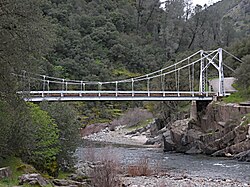
Briceburg Road. The bridge is a 160-foot (49 m) suspension bridge built by the US Forest Service in 1937 and constructed by 30 Civilian Conservation Corps enrollees. Forest Service Engineer J.W. Nute was in charge of construction. The community name honors William M. Brice, who built a
251:
After a 2019 fire, Pacific Gas & Electric decided to create a self-reliant power system rather than rebuilding poles and wires to serve the remote community. The stand-alone power grid includes solar panels, batteries and a backup generator.
1468:
1367:
382:
1473:
339:
1444:
1463:
738:
1372:
1257:
498:
987:
375:
145:
433:
1437:
663:
1240:
76:
731:
653:
623:
368:
1028:
109:
1430:
299:
55:
1377:
724:
360:
1206:
942:
755:
1362:
1357:
768:
1410:
1180:
508:
392:
228:
200:
1272:
1262:
1051:
1021:
633:
555:
483:
448:
244:
1300:
1267:
1245:
1165:
696:
683:
668:
513:
1250:
1079:
881:
862:
580:
473:
453:
443:
273:
1402:
1211:
1201:
648:
425:
1339:
1304:
1072:
921:
906:
901:
747:
658:
618:
590:
585:
570:
1295:
1155:
1086:
628:
608:
463:
458:
243:, at an elevation of 1138 feet (347 m). It is accessed via a bridge over the Merced River that connects
1334:
1329:
1319:
1314:
1042:
783:
703:
493:
488:
478:
438:
414:
240:
1290:
931:
678:
643:
638:
575:
565:
545:
535:
468:
224:
46:
324:
1309:
1137:
1058:
673:
560:
503:
1382:
1185:
1175:
916:
844:
613:
295:
1414:
1035:
808:
793:
1127:
1122:
952:
871:
818:
763:
1065:
1160:
1112:
992:
972:
962:
911:
833:
788:
1457:
1221:
982:
967:
851:
778:
180:
292:
California's
Geographic Names: A Gazetteer of Historic and Modern Names of the State
1170:
1132:
1002:
997:
773:
236:
61:
274:
U.S. Geological Survey
Geographic Names Information System: Briceburg, California
1117:
896:
891:
876:
803:
407:
977:
957:
886:
838:
798:
232:
190:
160:
147:
1107:
857:
828:
325:"Briceburg Fire fully contained at 5,563 acres, according to fire officials"
239:
near the confluence with Bear Creek, 5 miles (8 km) north-northwest of
1216:
716:
17:
720:
364:
1368:
National
Register of Historic Places in Yosemite National Park
930:
522:
340:"California tests off-the-grid solutions to power outages"
1469:
Unincorporated communities in
Mariposa County, California
1418:
294:. Clovis, Calif.: Word Dancer Press. p. 749-750.
32:
Unincorporated community in
California, United States
27:
Unincorporated community in
California, United States
1348:
1281:
1230:
1194:
1146:
1100:
1011:
941:
817:
754:
599:
534:
424:
206:
196:
186:
176:
37:
1438:
732:
376:
8:
1474:Mariposa County, California geography stubs
523:
1445:
1431:
814:
739:
725:
717:
383:
369:
361:
34:
1464:Unincorporated communities in California
261:
205:
175:
140:
68:
52:
269:
267:
265:
285:
283:
281:
195:
185:
7:
1399:
1397:
1073:Steck-Salathé Route (Sentinel Rock)
1417:. You can help Knowledge (XXG) by
1296:El Portal & Arch Rock Entrance
391:Municipalities and communities of
25:
116:
83:
1401:
789:Mariposa Grove of Giant Sequoias
115:
108:
82:
75:
54:
338:Nguyen, Daisy (June 30, 2021).
248:store at the location in 1926.
1207:1996 Yosemite Valley landslide
1:
132:Show map of the United States
129:Briceburg (the United States)
1363:Geology of the Yosemite area
1358:History of the Yosemite area
1411:Mariposa County, California
1156:Yosemite Lodge at the Falls
394:Mariposa County, California
1490:
1396:
210:1,138 ft (347 m)
1066:Salathé Wall (El Capitan)
1029:Half Dome, Northwest Face
1022:Fairview Dome, North Face
928:
692:
520:
405:
290:Durham, David L. (1998).
141:
69:
53:
44:
225:unincorporated community
47:Unincorporated community
1212:1997 Merced River flood
1202:1938 Yosemite TWA crash
235:. It is located on the
1413:–related article is a
1222:2022 Washburn Wildfire
935:
922:Yosemite Valley Chapel
902:Little Yosemite Valley
748:Yosemite National Park
528:
161:37.60500°N 119.96694°W
99:Show map of California
96:Location in California
1087:The Nose (El Capitan)
934:
526:
1043:Lost Arrow Spire Tip
705:United States portal
166:37.60500; -119.96694
527:Mariposa County map
157: /
1373:List of waterfalls
1138:Ahwahnechee people
1059:Royal Arches Route
1052:Midnight Lightning
936:
912:Bracebridge Dinner
529:
1426:
1425:
1391:
1390:
1383:California Portal
1378:Yosemite Category
1217:2013 Rim Wildfire
1195:Natural disasters
1181:High Sierra Camps
1176:Housekeeping Camp
1113:Stephen T. Mather
1096:
1095:
917:Yosemite Firefall
714:
713:
698:California portal
214:
213:
16:(Redirected from
1481:
1447:
1440:
1433:
1405:
1398:
1237:Nearby airports
1128:Buffalo Soldiers
1080:Separate Reality
1036:Lost Arrow Spire
815:
809:Chilnualna Falls
794:Tuolumne Meadows
769:Yosemite Village
741:
734:
727:
718:
706:
699:
525:
417:
410:
400:
395:
385:
378:
371:
362:
355:
354:
352:
350:
335:
329:
328:
321:
315:
314:Mariposa Gazette
312:
306:
305:
287:
276:
271:
172:
171:
169:
168:
167:
162:
158:
155:
154:
153:
150:
133:
119:
118:
112:
100:
86:
85:
79:
60:Bridge over the
58:
35:
21:
1489:
1488:
1484:
1483:
1482:
1480:
1479:
1478:
1454:
1453:
1452:
1451:
1394:
1392:
1387:
1350:
1344:
1283:
1277:
1226:
1190:
1148:
1142:
1123:Shelton Johnson
1092:
1013:
1007:
953:John Muir Trail
944:
937:
926:
872:Bridalveil Fall
821:
813:
764:Yosemite Valley
750:
745:
715:
710:
704:
697:
688:
601:
595:
537:
530:
518:
509:Yosemite Valley
420:
415:
408:
401:
398:
393:
389:
359:
358:
348:
346:
337:
336:
332:
323:
322:
318:
313:
309:
302:
289:
288:
279:
272:
263:
258:
229:Mariposa County
201:Mariposa County
165:
163:
159:
156:
151:
148:
146:
144:
143:
137:
136:
135:
134:
131:
130:
127:
126:
125:
124:
120:
103:
102:
101:
98:
97:
94:
93:
92:
91:
87:
65:
49:
40:
33:
28:
23:
22:
15:
12:
11:
5:
1487:
1485:
1477:
1476:
1471:
1466:
1456:
1455:
1450:
1449:
1442:
1435:
1427:
1424:
1423:
1406:
1389:
1388:
1386:
1385:
1380:
1375:
1370:
1365:
1360:
1354:
1352:
1346:
1345:
1343:
1342:
1337:
1332:
1327:
1322:
1317:
1312:
1307:
1298:
1293:
1287:
1285:
1284:municipalities
1279:
1278:
1276:
1275:
1270:
1265:
1260:
1255:
1254:
1253:
1248:
1243:
1234:
1232:
1231:Transportation
1228:
1227:
1225:
1224:
1219:
1214:
1209:
1204:
1198:
1196:
1192:
1191:
1189:
1188:
1183:
1178:
1173:
1168:
1163:
1158:
1152:
1150:
1144:
1143:
1141:
1140:
1135:
1130:
1125:
1120:
1115:
1110:
1104:
1102:
1098:
1097:
1094:
1093:
1091:
1090:
1083:
1076:
1069:
1062:
1055:
1048:
1047:
1046:
1032:
1025:
1017:
1015:
1009:
1008:
1006:
1005:
1000:
995:
993:Mariposa Grove
990:
985:
980:
975:
973:Ostrander Lake
970:
965:
963:Panorama Trail
960:
955:
949:
947:
939:
938:
929:
927:
925:
924:
919:
914:
909:
904:
899:
894:
889:
884:
879:
874:
869:
868:
867:
836:
834:Yosemite Falls
831:
825:
823:
812:
811:
806:
801:
796:
791:
786:
781:
776:
771:
766:
760:
758:
752:
751:
746:
744:
743:
736:
729:
721:
712:
711:
709:
708:
701:
693:
690:
689:
687:
686:
681:
676:
671:
666:
661:
656:
651:
646:
641:
636:
634:Horseshoe Bend
631:
626:
621:
616:
611:
605:
603:
597:
596:
594:
593:
588:
583:
578:
573:
568:
563:
558:
556:Clearing House
553:
548:
542:
540:
536:Unincorporated
532:
531:
521:
519:
517:
516:
511:
506:
501:
496:
491:
486:
484:Lake Don Pedro
481:
476:
471:
466:
461:
456:
451:
449:Catheys Valley
446:
441:
436:
430:
428:
422:
421:
406:
403:
402:
390:
388:
387:
380:
373:
365:
357:
356:
330:
316:
307:
300:
277:
260:
259:
257:
254:
212:
211:
208:
204:
203:
198:
194:
193:
188:
184:
183:
178:
174:
173:
139:
138:
128:
122:
121:
114:
113:
107:
106:
105:
104:
95:
89:
88:
81:
80:
74:
73:
72:
71:
70:
67:
66:
59:
51:
50:
45:
42:
41:
38:
31:
26:
24:
14:
13:
10:
9:
6:
4:
3:
2:
1486:
1475:
1472:
1470:
1467:
1465:
1462:
1461:
1459:
1448:
1443:
1441:
1436:
1434:
1429:
1428:
1422:
1420:
1416:
1412:
1407:
1404:
1400:
1395:
1384:
1381:
1379:
1376:
1374:
1371:
1369:
1366:
1364:
1361:
1359:
1356:
1355:
1353:
1347:
1341:
1338:
1336:
1333:
1331:
1328:
1326:
1323:
1321:
1318:
1316:
1313:
1311:
1308:
1306:
1302:
1301:Yosemite West
1299:
1297:
1294:
1292:
1289:
1288:
1286:
1280:
1274:
1271:
1269:
1266:
1264:
1261:
1259:
1256:
1252:
1249:
1247:
1244:
1242:
1239:
1238:
1236:
1235:
1233:
1229:
1223:
1220:
1218:
1215:
1213:
1210:
1208:
1205:
1203:
1200:
1199:
1197:
1193:
1187:
1184:
1182:
1179:
1177:
1174:
1172:
1169:
1167:
1164:
1162:
1159:
1157:
1154:
1153:
1151:
1145:
1139:
1136:
1134:
1131:
1129:
1126:
1124:
1121:
1119:
1116:
1114:
1111:
1109:
1106:
1105:
1103:
1099:
1089:
1088:
1084:
1082:
1081:
1077:
1075:
1074:
1070:
1068:
1067:
1063:
1061:
1060:
1056:
1054:
1053:
1049:
1045:
1044:
1040:
1039:
1038:
1037:
1033:
1031:
1030:
1026:
1024:
1023:
1019:
1018:
1016:
1010:
1004:
1001:
999:
996:
994:
991:
989:
986:
984:
983:Sentinel Dome
981:
979:
976:
974:
971:
969:
968:McGurk Meadow
966:
964:
961:
959:
956:
954:
951:
950:
948:
946:
940:
933:
923:
920:
918:
915:
913:
910:
908:
907:LeConte Lodge
905:
903:
900:
898:
895:
893:
890:
888:
885:
883:
880:
878:
875:
873:
870:
866:
865:
860:
859:
854:
853:
852:The Dawn Wall
848:
847:
842:
841:
840:
837:
835:
832:
830:
827:
826:
824:
820:
816:
810:
807:
805:
802:
800:
797:
795:
792:
790:
787:
785:
782:
780:
779:Glacier Point
777:
775:
772:
770:
767:
765:
762:
761:
759:
757:
753:
749:
742:
737:
735:
730:
728:
723:
722:
719:
707:
702:
700:
695:
694:
691:
685:
684:Yosemite Mill
682:
680:
677:
675:
672:
670:
669:Ridleys Ferry
667:
665:
662:
660:
657:
655:
652:
650:
647:
645:
642:
640:
637:
635:
632:
630:
627:
625:
622:
620:
617:
615:
612:
610:
607:
606:
604:
598:
592:
589:
587:
584:
582:
579:
577:
574:
572:
569:
567:
564:
562:
559:
557:
554:
552:
549:
547:
544:
543:
541:
539:
533:
515:
514:Yosemite West
512:
510:
507:
505:
502:
500:
497:
495:
492:
490:
487:
485:
482:
480:
477:
475:
472:
470:
467:
465:
462:
460:
457:
455:
452:
450:
447:
445:
442:
440:
437:
435:
432:
431:
429:
427:
423:
419:
418:
411:
404:
399:United States
396:
386:
381:
379:
374:
372:
367:
366:
363:
345:
341:
334:
331:
326:
320:
317:
311:
308:
303:
301:1-884995-14-4
297:
293:
286:
284:
282:
278:
275:
270:
268:
266:
262:
255:
253:
249:
246:
242:
238:
234:
230:
226:
222:
218:
209:
202:
199:
192:
189:
182:
181:United States
179:
170:
142:Coordinates:
111:
78:
63:
57:
48:
43:
36:
30:
19:
1419:expanding it
1408:
1393:
1324:
1171:Wawona Hotel
1161:The Ahwahnee
1133:Chief Tenaya
1085:
1078:
1071:
1064:
1057:
1050:
1041:
1034:
1027:
1020:
1003:Lembert Dome
998:Wapama Falls
864:To the Limit
863:
856:
850:
845:
774:Hetch Hetchy
581:Indian Gulch
550:
474:Greeley Hill
454:Coulterville
444:Buck Meadows
413:
347:. Retrieved
343:
333:
319:
310:
291:
250:
237:Merced River
220:
216:
215:
64:at Briceburg
62:Merced River
29:
1351:information
1149:and camping
1118:Galen Clark
988:Alder Creek
897:Nevada Fall
892:Vernal Fall
882:Mirror Lake
877:Happy Isles
822:attractions
804:Wawona Tree
784:Badger Pass
756:Attractions
649:Mount Ophir
602:settlements
538:communities
499:Mt. Bullion
434:Bear Valley
409:County seat
245:Highway 140
219:(formerly,
164: /
152:119°58′01″W
1458:Categories
1349:Additional
1340:Lee Vining
1305:Chinquapin
1166:Camp Curry
978:Taft Point
958:Mist Trail
887:North Dome
846:El Capitan
839:El Capitan
799:Tioga Pass
664:Quartzburg
659:Notomidula
619:Chinquapin
591:Mormon Bar
586:Jerseydale
571:Hites Cove
256:References
233:California
221:Bear Creek
191:California
149:37°36′18″N
1325:Briceburg
1273:Route 120
1263:Route 140
1108:John Muir
858:Free Solo
829:Half Dome
629:Hokokwito
609:Agua Fria
551:Briceburg
464:Fish Camp
459:El Portal
217:Briceburg
207:Elevation
123:Briceburg
90:Briceburg
39:Briceburg
18:Briceburg
1335:Midpines
1330:Oakhurst
1320:Mariposa
1315:Bootjack
1268:Route 41
494:Midpines
489:Mariposa
479:Hornitos
439:Bootjack
416:Mariposa
241:Midpines
223:) is an
1291:Foresta
1147:Lodging
843:Films:
679:Wiskala
654:Newtown
644:Macheto
639:Kumaini
624:Dogtown
576:Incline
566:Foresta
546:Ben Hur
469:Foresta
349:July 2,
344:AP News
177:Country
1310:Wawona
1303:&
1282:Nearby
1186:Camp 4
1101:People
1014:climbs
945:trails
943:Hiking
819:Valley
674:Sakaya
600:Former
561:Darrah
504:Wawona
298:
197:County
1409:This
1258:YARTS
1012:Rock
614:Bagby
187:State
1415:stub
426:CDPs
351:2021
296:ISBN
1251:MMH
1246:MPI
1241:FAT
227:in
1460::
861:,
855:,
849:,
412::
397:,
342:.
280:^
264:^
231:,
1446:e
1439:t
1432:v
1421:.
740:e
733:t
726:v
384:e
377:t
370:v
353:.
327:.
304:.
20:)
Text is available under the Creative Commons Attribution-ShareAlike License. Additional terms may apply.