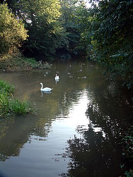
1627:, which was called Newnham until the early 19th century. Commercial End consists of a row of fine buildings, mainly dating from the late 17th and 18th century. The Commissioners of the Bedford Level were responsible for the drain during this period, and they cleared the channel and straightened the banks on several occasions in response to complaints. Use of the lode declined rapidly once the railways arrived in the area, and only the first 2 miles (3.2 km) to Slade Farm are currently navigable, as shallow water and low bridges prevent access beyond this point. There is a lock at the junction with the River Cam which can accommodate boats up to 96 by 15 feet (29.3 by 4.6 m), with a maximum draught of 2 feet (0.61 m). However, the Environment Agency have modified the upstream lock gate, in order to improve flood control, with the result that the headroom below the guillotine gate is too low for boats to enter the lode. The lower gates have also been removed.
1683:
feet (19 m) to gain access, and turning at Reach with a 58-foot (18 m) boat is possible. The lode is quite deep, for the surrounding land has sunk as the peat soils have dried out, and raising of the banks has resulted in the water being up to 10 feet (3.0 m) deep in places. In 2007 the
Environment Agency considered options for lowering the level of Reach Load and possibly some of the other lodes, as a way to reduce the maintenance of the banks. The report concluded that maintaining them at their present level was still the best solution, and a policy of strengthening the embankments was adopted as the way to limit the risk of major repairs being needed in the future.
1696:
1791:
1561:
1767:. There is a right of public navigation as far as its junction with Monk's Lode, and the stretch beyond that is only navigable by local inhabitants. The lode is not as wide or deep as the adjacent lodes, and can only be navigated by smaller craft. The waterway continues as Monk's Lode and then the New River, although these are not navigable. Peat from Burwell Fen was brought up Wicken Lode for much of the 19th century, for distribution to local farms, and the trade only stopped in the 1940s when peat cutting was restricted.
1679:, while incoming trade included building materials, stone, salts, wines and spirits. A lock was built at the start of the lode in 1821, as a result of the passing of the Eau Brink Act, while the South Level Commissioners took over responsibility for the waterway in 1827. Trade declined rapidly after railways reached the area in the 1850s, but some carriers continued to operate, with the last load of 525 tonnes of clunch being shipped in the early 1930s, and some peat being carried for a few years after that.
1419:
1299:
469:
1818:
rapid demise of water-borne transport. Commercial traffic ceased about 1900, and the lode was described as un-navigable in a report by H. Dunn in 1906. There was a sluice at the entrance to the lode, with two sets of mitre gates, pointing in opposite directions, one to prevent flood waters from the Great Ouse entering the lode, and the other to raise the water level in the lode to make navigation easier. When the
Anglian Water Authority was created by
1200:
3114:
3100:
1631:
1723:, ancient fossilised dung extracted from the newly drained fens, using a process which had been developed by a man who lived locally. The works became the Patent Manure Works in the 1890s, and following a partnership, was owned by Colchester and Ball, who ran a fleet of three steam tugs and a large number of lighters, which were carrying around 10,000 tons a year by the early 20th century, despite the fact that the works had been served by a
1222:
1164:
873:
718:
673:
628:
314:
61:
1066:
207:
1073:
524:
250:
1400:
1155:
586:
402:
376:
350:
285:
1439:
1366:
997:
505:
1279:
1272:
1265:
1258:
1136:
1030:
782:
775:
619:
538:
200:
1446:
1373:
1109:
1059:
1037:
935:
789:
531:
498:
435:
236:
214:
1380:
1335:
1328:
1306:
1238:
1230:
1193:
1129:
1102:
1004:
857:
612:
565:
442:
428:
322:
1344:
1080:
1023:
823:
579:
572:
278:
271:
264:
257:
243:
1172:
990:
971:
964:
942:
928:
909:
902:
881:
864:
850:
830:
816:
809:
768:
761:
741:
734:
726:
709:
689:
681:
664:
657:
636:
605:
558:
491:
462:
421:
395:
369:
343:
305:
1735:. The toll structure was complicated, as the South Level Commissioners were responsible for both Burwell Lode and Reach Lode, but tolls of 3 pence (1.2p) per ton were payable to the Burwell Fen Drainage Commissioners, and a further 3 pence per ton for use of the connecting stretch of Reach Lode had to be paid to the Swaffham and Bottisham Drainage Commissioners.
1756:
3086:
1611:. The timber-framed building dates from the late eighteenth century and has a low breastshot waterwheel. The mill machinery was replaced in 1868 by W Rawlings, and the external cladding dates from the 1934 and 1978 restoration. There is a pumping station and a set of mitred flood doors at the entrance to the lode, which were replaced in 2001, but a
1576:(a primitive lock with a single gate), of which the chamber survives. Its water supply comes from Quy Water, which flows through a mill just above the village before entering the lode near to the location of a basin and wharf. In medieval times, navigation along Quy Water was also possible, as there is evidence of moorings in the village of
1686:
The Reach annual fair, which received a charter from King John, has been moved to the May bank holiday from its original
Rogation Week date, to ensure that every Mayor of Cambridge, who by tradition opens the fair, gets to open one fair during a term of office. The movable date of Rogation Week meant
1742:
took over the factory in 1929. Prentice's lighters were bought by A. V. Jackson in 1936, and
Jacksons continued to carry fertilizer until 1948. Trade in sugarbeet continued until 1963. Production of fertilizer at the site ceased in 1962, and the brickworks, which made up to 10 million bricks a year,
1591:
for improving agricultural land, was extensive in
Cambridgeshire. Initially the industry thrived further to the south, but noticing the profits that farmers were making, the commissioners decided to renovate the lode. In 1871, they applied to the South Level Board for permission to scour the channel
1510:
notice. Swaffham
Bulbeck Lode has been rendered unnavigable by the removal of the lower lock gates, and the replacement of the upper lock gates with a guillotine gate which provides little headroom. Reach Lode is quite deep, as a result of the surrounding land sinking, and the banks being built up.
1817:
There is no evidence that the Lode was navigable beyond Soham. Lighters brought cargoes of corn to a water mill at Soham, and later brought coal when steam engines replaced the water wheel. Barley and timber were other important cargoes. Railways did not reach Soham until 1879, and resulted in the
1539:
Research by the Royal
Commission on Historical Monuments published in 1972 confirmed the work of Major Gordon Fowler of the Fenland Research Committee that the Cambridgeshire lodes were of Roman origin; they were excavated to provide navigation to a series of villages to the east of the River Cam,
1781:
bought their first part of it in 1899. Purchases have continued, and the Trust now manages 730 acres (300 ha) of wetland. It is not a true fen, as the area is higher than the surrounding land, but since 1956 the wetland has been maintained by a drainage windmill pump which was moved from its
1715:
and joins Reach Lode about 0.75 miles (1.21 km) from the River Cam. The present course of the Lode was cut in the mid seventeenth century, replacing the previous course, which was referred to as the Old Lode. At
Burwell, two branches diverge in opposite directions, both of which had wharves.
1682:
Upware Lock, at 50 by 13.5 feet (15.2 by 4.1 m), used to restrict the size of boats that could use the lode, and boats longer than 45 feet (14 m) could not be turned at Reach. However, the mitre gates at the downstream end have been replaced by a guillotine gate, enabling boats up to 63
1603:
In 1875, the
Drainage Commissioners spent £294 (equivalent to £34,984 in 2023) on a flash lock, which had a flagstone floor, a chamber constructed of white bricks, a timber guillotine gate, and a mechanism for raising the gate made from cast-iron, supported by a timber frame. The chamber was
1514:
Burwell Lode is a tributary of Reach Lode, and is another deep lode. Barges were built and maintained at
Burwell until 1936, and it was used commercially until 1963, when carriage of sugar beet ceased. Wicken Lode is another tributary of Reach Lode, and was important for the carriage of peat and
1746:
The waterway is comparatively wide, at 40 to 45 feet (12 to 14 m), and the junction of the branches at Burwell provides a point at which long boats can be turned, but the modern lock at Upware restricts access to boats less than 63 feet (19 m) long. It is also quite deep, and the 2007
1730:
Prentice Brothers Ltd, who had built barges at Burwell until 1920, and repaired and maintained them there until 1936, took over the Manure Works in 1921. In addition to the fertilizer, the barges carried coal, stone and sugar beet, and the yellow bricks produced by the
1825:
There is now a pumping station and a set of mitred flood doors at the start of the lode, and although it is not officially navigable, two narrowboats navigated part of it in 2001, and there is increasing evidence that boats can and do use it as far as it is possible.
1592:
as it was in a bad state, and they noted that "parties in charge of Barges throw off the lock doors to enable them to get up the Lode." The South Level Board replied that if conditions did not improve those transporting coprolite on the lode might take their trade to
1580:. The Swaffham and Bottisham Drainage Commissioners were responsible for the lode from 1767, and were empowered to build staunches and collect tolls. The lode was never wide enough to take fen lighters, but smaller boats used it for most of the 19th century.
1604:
11.75 feet (3.58 m) wide, and the mechanism included a winding drum with winding wheel, and cogwheels with ratchets. The timber frame was demolished in 1968 but the chamber still survives, some 1,010 yards (920 m) upstream from the entrance gates.
1651:, ran for a further 7.5 miles (12.1 km) in a straight line to Ditton Green. The ditch is around 15 feet (4.6 m) deep and the rampart some 18 feet (5.5 m) high. It was built in the Anglo-Saxon period, and is listed as a
1530:
In 2007 a strategy plan considered options for the management of the lodes which included rebuilding most of them at a lower level, but concluded that maintaining the banks at the existing level was a better long-term solution.
1782:
location at Adventurers Fen, to the south of the lode, and re-assembled to supply the Fen with water. The National Trust Warden's office includes a display which tells the history of the Fen and how it has been managed.
1551:
The term "Lode" denoted a watercourse in Late Middle English, being derived from the Old English "lād," meaning way or course. It did not acquire its modern meaning of a vein of metal ore until the early 17th century.
1662:
The village of Reach has been a trading port since Roman times. From the 13th century, a fair was held there, and it was at this time that the last 300 yards (270 m) of the Devils Dyke were levelled.
1778:
1608:
1524:
1802:
about 1 mile (1.6 km) below its junction with the River Cam. Its origin is less well known than the other lodes, but it probably dates from the 1790s, when it was built to reduce flooding in the
1527:
bought their first part of it in 1899. Soham Lode is more recent than most, probably dating from the 1790s. It ran by Soham Mere, a large inland lake which was drained in the late 18th century.
2169:
2322:
3154:
2271:
2425:
2374:
3793:
2574:
2118:
2067:
1964:
1913:
1834:
Cottenham Lode has two branches, both of which empty in the Great Ouse. Previously the western branch was named Robbin's Lode, but now both carry the Cottenham Lode title.
1814:, to join the Great Ouse instead. Soham is about halfway along it, and was once close to a large inland lake called Soham Mere, which was drained in the late 18th century.
2220:
163:
1596:, with the loss of significant tolls, and in 1872 the construction of a staunch lock was agreed, which would be the same as those on the Brandon River (now known as the
2016:
3662:
1719:
Burwell became more important than Reach when T. T. Ball opened the Burwell Chemical Works, which was built between 1864 and 1865. Fertilizer was produced from
1822:
in 1977, the lode was not listed as a navigation, and their successors, the Environment Agency, have taken this to mean that there is no right of navigation.
1667:
and basins were developed, and coasters brought a wide variety of products to Reach and to the fair. The coasters stopped when Denver Sluice was built on the
1643:
Reach Lode joins the River Cam at Upware, a further 2.3 miles (3.7 km) below Swaffham Bulbeck Lode, and runs for 3 miles (4.8 km) to the village of
3682:
3766:
river. Partly or mostly navigable, and/or under restoration. A system of canals. Canals which form part of this system are not listed here individually.
1572:
to the River Cam just below Bottisham lock, and is about 2.5 miles (4.0 km) long. It is almost straight, running between embankments, and included a
3147:
1540:
and probably also drainage of the surrounding fenland. The infrastructure was completed by the Car Dyke, which linked Waterbeach on the River Cam to the
1607:
Navigation on the lode ceased around 1900, and it is not currently navigable. The mill at Lode has been restored to working order by its owners, the
3453:
1623:
Swaffham Bulbeck Lode joins the River Cam about 1.5 miles (2.4 km) below Bottisham Lode. It runs for 3.4 miles (5.5 km) to the hamlet of
3298:
3473:
156:
21:
3140:
2508:
2489:
3788:
1763:
Wicken Lode turns off Reach Lode, and crosses Wicken Sedge Fen, running for nearly 1.5 miles (2.4 km) to just short of the village of
3718:
1656:
1506:
Bottisham Lode was navigated throughout the 19th century, and although the flood gates at its mouth were replaced in 2001, it carries a
2736:
1511:
The lower gate of the entrance lock has been replaced by a guillotine gate, enabling boats up to 63 feet (19 m) long to use it.
3238:
2527:
149:
3368:
3033:
2765:
2581:
1560:
2731:
2635:
1648:
3631:
3538:
3393:
3278:
3090:
2881:
1790:
1727:
since 1900. Richard Ball had opened a brickworks nearby, which was served by a channel which became known as Factory Lode.
3523:
1898:
1695:
3228:
3213:
3203:
3164:
1847:
3783:
3178:
3569:
3738:
3488:
3333:
3313:
181:
1671:, but smaller vessels continued to trade in agricultural produce, timber and a type of building material called
3383:
3308:
1747:
Strategy Study considered the option of reconstructing it at a lower level, but did not recommend this action.
1593:
3672:
3641:
3533:
3503:
3498:
3303:
3127:
1807:
1712:
1045:
1874:
1771:
from the fen was transported by boat from the sites where it was cut to a wharf near the head of the lode.
1732:
3708:
3610:
3528:
3508:
3493:
3468:
3458:
1764:
1573:
1869:
3605:
3378:
3373:
3323:
3105:
1891:
1644:
1545:
950:
3438:
3363:
3258:
1864:
1569:
1314:
3723:
3463:
3288:
1716:'Anchor Straits' to the south was used by coasters and 'Weirs' to the north was used by lighters.
3743:
3518:
3358:
3243:
2561:
1652:
2706:
An Inventory of Historical Monuments in the County of Cambridgeshire, Vol 2: N E Cambridgeshire
3763:
3748:
3728:
3703:
3483:
3418:
3413:
3408:
3283:
3208:
3193:
2709:
2553:
2523:
2504:
2485:
1819:
1597:
3636:
3626:
3595:
3554:
3478:
3398:
3388:
3348:
3248:
3119:
2727:
2593:
1799:
1668:
1630:
1624:
1500:
222:
3058:
3713:
3328:
3263:
3113:
1724:
3132:
1495:. Bottisham, Swaffham Bulbeck, Reach, Burwell, Wicken and Monks Lodes all connect to the
3574:
3433:
3338:
3293:
3253:
3218:
3029:
2761:
1704:
1488:
60:
1655:, while the chalk grasslands which it contains have resulted in it being a designated
3777:
3646:
3343:
3318:
3268:
3198:
2537:
1503:. All have been navigable historically, but some are no longer officially navigable.
1484:
2639:
1859:
1794:
Barway Bridge crossing Soham Lode on a section that is still deep enough to navigate
3687:
3600:
3579:
3513:
3443:
3403:
3353:
3188:
1577:
1541:
2885:
3667:
3564:
3559:
3448:
3428:
3423:
3183:
3733:
3677:
3223:
3095:
1811:
1774:
1768:
1720:
1700:
1676:
1520:
1516:
2557:
2441:
2427:
2390:
2376:
2338:
2324:
2287:
2273:
2236:
2222:
2185:
2171:
2134:
2120:
2083:
2069:
2032:
2018:
1980:
1966:
1929:
1915:
1810:
area, by carrying water from the River Snail, which formerly flowed into the
36:
23:
3273:
1588:
1584:
1496:
1088:
3085:
1755:
142:
2565:
1634:
The lock at the junction between Swaffham Bulbeck Lode and the River Cam
2713:
2541:
1492:
2594:"A History of the County of Cambridge and the Isle of Ely: Volume 10"
1739:
1672:
2794:
1803:
1789:
1754:
1694:
1664:
1629:
1559:
477:
65:
The pumping station and flood gates at the end of Bottisham Lode
3136:
1687:
that some mayors opened two fairs, and some did not open any.
2580:. Halcrow Group Ltd and Environment Agency. Archived from
1798:
Soham Lode runs for about 7 miles (11 km) from the
1777:
is one of the oldest nature reserves in England, as the
1523:, one of the oldest nature reserves in England, as the
2676:
2674:
1703:, in December 2013. There are plans to replace this
1647:. From Reach, a defensive rampart and ditch, called
3696:
3655:
3619:
3588:
3547:
3171:
2804:. East Anglian Waterways Association. February 2008
1483:are a series of man-made waterways, believed to be
133:
128:
120:
112:
104:
99:
91:
83:
75:
70:
53:
3059:"Cottenham: Introduction | British History Online"
1499:, while Soham and Cottenham Lodes connect to the
3148:
2962:
157:
16:Man-made waterways in Cambridgeshire, England
8:
3004:
2989:
2943:
2906:
2825:
2665:
2638:. Oxford Living Dictionaries. Archived from
2622:
3000:
2998:
2939:
2937:
2935:
2933:
2931:
2929:
2917:
2915:
2852:
2821:
2819:
2520:Inland Waterways of Great Britain (7th Ed.)
1615:notice was displayed on the gates in 2008.
1229:
1221:
321:
313:
3794:Buildings and structures in Cambridgeshire
3155:
3141:
3133:
2973:
2971:
2864:
2862:
2860:
2661:
2659:
2657:
1884:
189:
164:
150:
50:
1171:
1163:
880:
872:
725:
717:
680:
672:
635:
627:
1418:
1298:
468:
2921:
2848:
2846:
2756:
2754:
2615:
1699:'Cockup Bridge' over Burwell Lode near
147:
2958:
2956:
2954:
2952:
2789:
2787:
2785:
2783:
1711:Burwell Lode runs from the village of
1199:
3053:
3051:
3016:
2977:
2868:
2837:
2692:
2680:
2499:Boyes, John; Russell, Ronald (1977).
1600:). The cost of the project was £750.
7:
2768:from the original on 2 February 2017
2592:Wareham, A F; Wright, A P M (2002).
2542:"Coprolite Mining in Cambridgeshire"
2482:The River Great Ouse and tributaries
1568:Bottisham Lode links the village of
1548:, some 73 miles (117 km) away.
1487:in origin, located in the county of
3719:History of the British canal system
2575:"The Ely Ouse Lodes Strategy Study"
1657:Site of Special Scientific Interest
3032:. Tuesday Night Club. p. 20.
2764:. Tuesday Night Club. p. 21.
2737:National Heritage List for England
1399:
1154:
1065:
401:
375:
349:
284:
206:
14:
3299:Herefordshire and Gloucestershire
3036:from the original on 4 March 2016
2882:"Devils Dyke Restoration Project"
2522:. Imray Laurie Norie and Wilson.
2484:. Imray Laurie Norie and Wilson.
1438:
1365:
1072:
996:
523:
504:
249:
3474:Staffordshire and Worcestershire
3112:
3098:
3084:
2418:
2367:
2315:
2264:
2213:
2162:
2111:
2060:
2009:
1957:
1906:
1444:
1437:
1417:
1398:
1378:
1371:
1364:
1342:
1333:
1326:
1304:
1297:
1278:
1277:
1271:
1270:
1264:
1263:
1257:
1256:
1236:
1228:
1220:
1198:
1191:
1170:
1162:
1153:
1135:
1134:
1127:
1107:
1100:
1078:
1071:
1064:
1057:
1035:
1028:
1021:
1002:
995:
988:
969:
962:
940:
933:
926:
907:
900:
879:
871:
862:
855:
848:
828:
821:
814:
807:
787:
780:
774:
773:
766:
759:
739:
732:
724:
716:
707:
687:
679:
671:
662:
655:
634:
626:
617:
610:
603:
585:
584:
577:
570:
563:
556:
536:
529:
522:
503:
496:
489:
467:
460:
440:
433:
426:
419:
400:
393:
374:
367:
348:
341:
320:
312:
303:
283:
276:
269:
262:
255:
248:
241:
234:
212:
205:
198:
59:
2546:The Agricultural History Review
2317:Start of Swaffham Bulbeck Lode
2164:Wicken Lode jn with Monks Lode
1445:
1372:
1108:
1058:
1036:
934:
788:
530:
497:
434:
235:
213:
2350:Start of Swaffham Bulbeck Lode
2197:Wicken Lode jn with Monks Lode
1675:, which were exported through
1379:
1334:
1327:
1305:
1237:
1192:
1128:
1101:
1029:
1003:
856:
781:
618:
611:
564:
537:
441:
427:
199:
1:
3454:Sheffield and South Yorkshire
2501:The Canals of Eastern England
2480:Blair, Andrew Hunter (2006).
1343:
1079:
1022:
822:
578:
571:
277:
270:
263:
256:
242:
3369:Manchester Bolton & Bury
3204:Birmingham Canal Navigations
3165:canals of the United Kingdom
2732:"Water Mill, Lode (1127088)"
1587:, to be used as a source of
989:
970:
963:
941:
927:
908:
901:
863:
849:
829:
815:
808:
767:
760:
740:
733:
708:
688:
663:
656:
604:
557:
490:
461:
420:
394:
368:
342:
304:
3789:Transport in Cambridgeshire
2266:Swaffham Bulbeck Lode lock
1875:GPX (secondary coordinates)
137:River Cam, River Great Ouse
3810:
2518:Cumberlidge, Jane (1998).
2299:Swaffham Bulbeck Lode lock
1653:Scheduled Ancient Monument
3757:
3739:National Waterways Museum
3063:www.british-history.ac.uk
2963:Wareham & Wright 2002
1895:(Links to map resources)
1870:GPX (primary coordinates)
1845:Map all coordinates using
1613:"No unauthorised vessels"
1508:"No unauthorised vessels"
1453:
1431:
1426:
1411:
1407:
1392:
1387:
1358:
1353:
1320:
1313:
1291:
1286:
1250:
1245:
1212:
1207:
1185:
1180:
1147:
1143:
1121:
1116:
1094:
1087:
1051:
1044:
1015:
1011:
982:
978:
956:
949:
920:
916:
894:
889:
842:
837:
801:
796:
753:
748:
701:
696:
649:
644:
597:
593:
550:
545:
516:
512:
483:
476:
454:
449:
413:
409:
387:
383:
361:
357:
335:
330:
297:
292:
228:
221:
192:
58:
3632:Monmouthshire and Brecon
3539:Worcester and Birmingham
3394:North Walsham and Dilham
3384:Middle Level Navigations
3279:Gloucester and Sharpness
3005:Boyes & Russell 1977
2990:Boyes & Russell 1977
2944:Boyes & Russell 1977
2907:Boyes & Russell 1977
2826:Boyes & Russell 1977
2666:Boyes & Russell 1977
2623:Boyes & Russell 1977
2596:. British History Online
2369:Mouth of Bottisham Lode
1853:Download coordinates as:
1743:finally closed in 1971.
1594:Fulbourn railway station
1583:In the 1860s, mining of
3709:Canal & River Trust
3534:Witham Navigable Drains
3128:Canals of Great Britain
2420:Bottisham Lode at Lode
2402:Mouth of Bottisham Lode
1738:The fertilizer company
1287:Disused railway bridge
3469:South Forty-Foot Drain
3319:Ipswich and Stowmarket
3239:Chelmer and Blackwater
3214:Bridgwater and Taunton
2453:Bottisham Lode at Lode
2215:Mouth of Burwell Lode
1795:
1760:
1708:
1635:
1565:
1181:Swaffham Bulbeck Lode
108:Drainage Commissioners
3570:Shannon–Erne Waterway
3374:Manchester Ship Canal
3106:United Kingdom portal
3093:at Wikimedia Commons
2503:. David and Charles.
2248:Mouth of Burwell Lode
2113:Mouth of Wicken Lode
1865:GPX (all coordinates)
1793:
1758:
1733:Burwell Brick Company
1698:
1633:
1619:Swaffham Bulbeck Lode
1563:
3439:Royal Military Canal
3364:Maidenhead Waterways
3234:Cambridgeshire Lodes
3091:Cambridgeshire Lodes
2642:on 29 September 2016
2636:"Definition of Lode"
2146:Mouth of Wicken Lode
2062:Reach Lode at Reach
1959:Soham Lode at Soham
1908:Mouth of Soham Lode
1707:with a fixed bridge.
1481:Cambridgeshire Lodes
173:Cambridgeshire Lodes
124:Roman period onwards
92:Navigation authority
54:Cambridgeshire Lodes
3724:London Canal Museum
3489:Stratford-upon-Avon
3334:Leeds and Liverpool
3314:Huddersfield Narrow
3030:"2001 cruising log"
2992:, pp. 176–177.
2909:, pp. 174–175.
2795:"More on the Lodes"
2762:"2001 cruising log"
2625:, pp. 171–172.
2587:on 3 February 2011.
2437: /
2386: /
2334: /
2283: /
2232: /
2181: /
2130: /
2095:Reach Lode at Reach
2079: /
2028: /
1992:Soham Lode at Soham
1976: /
1941:Mouth of Soham Lode
1925: /
1117:Swaffham Lode Lock
33: /
3744:Navigable aqueduct
3309:Huddersfield Broad
3007:, pp. 177–178
2965:, pp. 347–356
2946:, pp. 175–176
2840:, pp. 99–100.
2828:, pp. 173–174
2442:52.2447°N 0.2409°E
2391:52.2695°N 0.2120°E
2339:52.2465°N 0.2750°E
2288:52.2819°N 0.2304°E
2237:52.3000°N 0.2684°E
2186:52.3075°N 0.2864°E
2135:52.3032°N 0.2606°E
2084:52.2735°N 0.2927°E
2033:52.3056°N 0.2533°E
1981:52.3319°N 0.3404°E
1930:52.3641°N 0.2601°E
1838:Points of interest
1796:
1761:
1709:
1636:
1566:
1519:. It runs through
293:Soham Lode sluice
95:Environment Agency
3784:Canals in England
3771:
3770:
3749:Waterways Ireland
3729:Manchester Pusher
3704:British Waterways
3642:Neath and Tennant
3529:Wilts & Berks
3524:Wey and Godalming
3504:Thames and Severn
3499:Thames and Medway
3304:Hollinwood Branch
3229:Calder and Hebble
3194:Basingstoke Canal
3184:Ashby-de-la-Zouch
3089:Media related to
2695:, pp. 37–38.
2510:978-0-7153-7415-3
2491:978-0-85288-943-5
2470:
2469:
1820:Act of Parliament
1598:River Little Ouse
1477:
1476:
1473:
1472:
797:High Head Bridge
141:
140:
121:Date of first use
3801:
3663:Aqueducts (list)
3637:Montgomery Canal
3627:Llangollen Canal
3596:Caledonian Canal
3555:Coalisland Canal
3548:Northern Ireland
3509:Trent and Mersey
3459:Shropshire Union
3157:
3150:
3143:
3134:
3122:
3120:Transport portal
3117:
3116:
3108:
3103:
3102:
3101:
3088:
3074:
3073:
3071:
3069:
3055:
3046:
3045:
3043:
3041:
3026:
3020:
3014:
3008:
3002:
2993:
2987:
2981:
2975:
2966:
2960:
2947:
2941:
2924:
2919:
2910:
2904:
2898:
2897:
2895:
2893:
2884:. Archived from
2878:
2872:
2866:
2855:
2853:Cumberlidge 1998
2850:
2841:
2835:
2829:
2823:
2814:
2813:
2811:
2809:
2799:
2791:
2778:
2777:
2775:
2773:
2758:
2749:
2748:
2746:
2744:
2728:Historic England
2724:
2718:
2717:
2702:
2696:
2690:
2684:
2678:
2669:
2663:
2652:
2651:
2649:
2647:
2632:
2626:
2620:
2605:
2603:
2601:
2588:
2586:
2579:
2573:Halcrow (2007).
2569:
2533:
2514:
2495:
2461:
2460:
2458:
2457:
2456:
2454:
2449:
2448:
2443:
2438:
2435:
2434:
2433:
2430:
2410:
2409:
2407:
2406:
2405:
2403:
2398:
2397:
2392:
2387:
2384:
2383:
2382:
2379:
2358:
2357:
2355:
2354:
2353:
2351:
2346:
2345:
2340:
2335:
2332:
2331:
2330:
2327:
2307:
2306:
2304:
2303:
2302:
2300:
2295:
2294:
2289:
2284:
2281:
2280:
2279:
2276:
2256:
2255:
2253:
2252:
2251:
2249:
2244:
2243:
2238:
2233:
2230:
2229:
2228:
2225:
2205:
2204:
2202:
2201:
2200:
2198:
2193:
2192:
2187:
2182:
2179:
2178:
2177:
2174:
2154:
2153:
2151:
2150:
2149:
2147:
2142:
2141:
2136:
2131:
2128:
2127:
2126:
2123:
2103:
2102:
2100:
2099:
2098:
2096:
2091:
2090:
2085:
2080:
2077:
2076:
2075:
2072:
2052:
2051:
2049:
2048:
2047:
2045:
2040:
2039:
2034:
2029:
2026:
2025:
2024:
2021:
2011:Reach Lode lock
2006:Below Brook Dam
2000:
1999:
1997:
1996:
1995:
1993:
1988:
1987:
1982:
1977:
1974:
1973:
1972:
1969:
1949:
1948:
1946:
1945:
1944:
1942:
1937:
1936:
1931:
1926:
1923:
1922:
1921:
1918:
1885:
1800:River Great Ouse
1669:River Great Ouse
1501:River Great Ouse
1448:
1447:
1441:
1440:
1421:
1420:
1402:
1401:
1382:
1381:
1375:
1374:
1368:
1367:
1346:
1345:
1337:
1336:
1330:
1329:
1308:
1307:
1301:
1300:
1281:
1280:
1274:
1273:
1267:
1266:
1260:
1259:
1240:
1239:
1232:
1231:
1224:
1223:
1202:
1201:
1195:
1194:
1174:
1173:
1166:
1165:
1157:
1156:
1138:
1137:
1131:
1130:
1111:
1110:
1104:
1103:
1082:
1081:
1075:
1074:
1068:
1067:
1061:
1060:
1039:
1038:
1032:
1031:
1025:
1024:
1006:
1005:
999:
998:
992:
991:
973:
972:
966:
965:
944:
943:
937:
936:
930:
929:
911:
910:
904:
903:
883:
882:
875:
874:
866:
865:
859:
858:
852:
851:
832:
831:
825:
824:
818:
817:
811:
810:
791:
790:
784:
783:
777:
776:
770:
769:
763:
762:
743:
742:
736:
735:
728:
727:
720:
719:
711:
710:
691:
690:
683:
682:
675:
674:
666:
665:
659:
658:
638:
637:
630:
629:
621:
620:
614:
613:
607:
606:
588:
587:
581:
580:
574:
573:
567:
566:
560:
559:
546:Reach Lode Lock
540:
539:
533:
532:
526:
525:
507:
506:
500:
499:
493:
492:
471:
470:
464:
463:
444:
443:
437:
436:
430:
429:
423:
422:
404:
403:
397:
396:
378:
377:
371:
370:
352:
351:
345:
344:
324:
323:
316:
315:
307:
306:
287:
286:
280:
279:
273:
272:
266:
265:
259:
258:
252:
251:
245:
244:
238:
237:
223:River Great Ouse
216:
215:
209:
208:
202:
201:
190:
166:
159:
152:
143:
63:
51:
48:
47:
45:
44:
43:
38:
37:52.147°N 0.313°E
34:
31:
30:
29:
26:
3809:
3808:
3804:
3803:
3802:
3800:
3799:
3798:
3774:
3773:
3772:
3767:
3753:
3714:Scottish Canals
3692:
3651:
3615:
3606:Forth and Clyde
3584:
3543:
3379:Market Weighton
3324:Kennet and Avon
3179:Aire and Calder
3167:
3161:
3118:
3111:
3104:
3099:
3097:
3082:
3077:
3067:
3065:
3057:
3056:
3049:
3039:
3037:
3028:
3027:
3023:
3015:
3011:
3003:
2996:
2988:
2984:
2976:
2969:
2961:
2950:
2942:
2927:
2920:
2913:
2905:
2901:
2891:
2889:
2880:
2879:
2875:
2867:
2858:
2851:
2844:
2836:
2832:
2824:
2817:
2807:
2805:
2797:
2793:
2792:
2781:
2771:
2769:
2760:
2759:
2752:
2742:
2740:
2726:
2725:
2721:
2704:
2703:
2699:
2691:
2687:
2679:
2672:
2664:
2655:
2645:
2643:
2634:
2633:
2629:
2621:
2617:
2613:
2608:
2599:
2597:
2591:
2584:
2577:
2572:
2536:
2530:
2517:
2511:
2498:
2492:
2479:
2475:
2452:
2450:
2447:52.2447; 0.2409
2446:
2444:
2440:
2439:
2436:
2431:
2428:
2426:
2424:
2423:
2401:
2399:
2396:52.2695; 0.2120
2395:
2393:
2389:
2388:
2385:
2380:
2377:
2375:
2373:
2372:
2364:Commercial End
2349:
2347:
2344:52.2465; 0.2750
2343:
2341:
2337:
2336:
2333:
2328:
2325:
2323:
2321:
2320:
2298:
2296:
2293:52.2819; 0.2304
2292:
2290:
2286:
2285:
2282:
2277:
2274:
2272:
2270:
2269:
2247:
2245:
2242:52.3000; 0.2684
2241:
2239:
2235:
2234:
2231:
2226:
2223:
2221:
2219:
2218:
2196:
2194:
2191:52.3075; 0.2864
2190:
2188:
2184:
2183:
2180:
2175:
2172:
2170:
2168:
2167:
2145:
2143:
2140:52.3032; 0.2606
2139:
2137:
2133:
2132:
2129:
2124:
2121:
2119:
2117:
2116:
2094:
2092:
2089:52.2735; 0.2927
2088:
2086:
2082:
2081:
2078:
2073:
2070:
2068:
2066:
2065:
2044:Reach Lode lock
2043:
2041:
2038:52.3056; 0.2533
2037:
2035:
2031:
2030:
2027:
2022:
2019:
2017:
2015:
2014:
1991:
1989:
1986:52.3319; 0.3404
1985:
1983:
1979:
1978:
1975:
1970:
1967:
1965:
1963:
1962:
1940:
1938:
1935:52.3641; 0.2601
1934:
1932:
1928:
1927:
1924:
1919:
1916:
1914:
1912:
1911:
1894:
1883:
1882:
1881:
1880:
1879:
1840:
1832:
1788:
1753:
1693:
1641:
1621:
1558:
1537:
1449:
1442:
1427:Commercial End
1422:
1403:
1383:
1376:
1369:
1349:
1348:
1347:
1338:
1331:
1309:
1302:
1282:
1275:
1268:
1261:
1246:Bottisham Lode
1241:
1234:
1233:
1226:
1225:
1203:
1196:
1176:
1175:
1168:
1167:
1158:
1139:
1132:
1112:
1105:
1083:
1076:
1069:
1062:
1040:
1033:
1026:
1007:
1000:
993:
974:
967:
945:
938:
931:
912:
905:
885:
884:
877:
876:
867:
860:
853:
838:Lifting bridge
833:
826:
819:
812:
792:
785:
778:
771:
764:
744:
737:
730:
729:
722:
721:
712:
692:
685:
684:
677:
676:
667:
660:
640:
639:
632:
631:
622:
615:
608:
589:
582:
575:
568:
561:
541:
534:
527:
508:
501:
494:
472:
465:
450:Railway Bridge
445:
438:
431:
424:
405:
398:
379:
372:
353:
346:
326:
325:
318:
317:
308:
288:
281:
274:
267:
260:
253:
246:
239:
217:
210:
203:
184:
175:
174:
170:
66:
41:
39:
35:
32:
27:
24:
22:
20:
19:
17:
12:
11:
5:
3807:
3805:
3797:
3796:
3791:
3786:
3776:
3775:
3769:
3768:
3758:
3755:
3754:
3752:
3751:
3746:
3741:
3736:
3731:
3726:
3721:
3716:
3711:
3706:
3700:
3698:
3697:Related topics
3694:
3693:
3691:
3690:
3685:
3683:Tunnels (list)
3680:
3675:
3670:
3665:
3659:
3657:
3653:
3652:
3650:
3649:
3644:
3639:
3634:
3629:
3623:
3621:
3617:
3616:
3614:
3613:
3608:
3603:
3598:
3592:
3590:
3586:
3585:
3583:
3582:
3577:
3575:Strabane Canal
3572:
3567:
3562:
3557:
3551:
3549:
3545:
3544:
3542:
3541:
3536:
3531:
3526:
3521:
3516:
3511:
3506:
3501:
3496:
3491:
3486:
3481:
3476:
3471:
3466:
3461:
3456:
3451:
3446:
3441:
3436:
3431:
3426:
3421:
3419:Regent's Canal
3416:
3411:
3406:
3401:
3396:
3391:
3386:
3381:
3376:
3371:
3366:
3361:
3356:
3351:
3346:
3341:
3339:Lee Navigation
3336:
3331:
3326:
3321:
3316:
3311:
3306:
3301:
3296:
3291:
3286:
3281:
3276:
3271:
3266:
3261:
3256:
3251:
3246:
3241:
3236:
3231:
3226:
3221:
3219:Buckingham Arm
3216:
3211:
3206:
3201:
3196:
3191:
3186:
3181:
3175:
3173:
3169:
3168:
3162:
3160:
3159:
3152:
3145:
3137:
3131:
3130:
3124:
3123:
3109:
3081:
3078:
3076:
3075:
3047:
3021:
3009:
2994:
2982:
2967:
2948:
2925:
2911:
2899:
2888:on 1 July 2012
2873:
2856:
2842:
2830:
2815:
2802:The Easterling
2779:
2750:
2719:
2708:. HMSO. 1972.
2697:
2685:
2683:, p. 100.
2670:
2653:
2627:
2614:
2612:
2609:
2607:
2606:
2589:
2570:
2538:Grove, Richard
2534:
2528:
2515:
2509:
2496:
2490:
2476:
2474:
2471:
2468:
2467:
2465:
2462:
2421:
2417:
2416:
2414:
2411:
2370:
2366:
2365:
2362:
2359:
2318:
2314:
2313:
2311:
2308:
2267:
2263:
2262:
2260:
2257:
2216:
2212:
2211:
2209:
2206:
2165:
2161:
2160:
2158:
2155:
2114:
2110:
2109:
2107:
2104:
2063:
2059:
2058:
2056:
2053:
2012:
2008:
2007:
2004:
2001:
1960:
1956:
1955:
1953:
1950:
1909:
1905:
1904:
1901:
1896:
1889:
1878:
1877:
1872:
1867:
1862:
1856:
1850:
1843:
1842:
1841:
1839:
1836:
1831:
1830:Cottenham Lode
1828:
1787:
1784:
1779:National Trust
1752:
1749:
1725:railway siding
1705:lifting bridge
1692:
1689:
1640:
1637:
1625:Commercial End
1620:
1617:
1609:National Trust
1557:
1556:Bottisham Lode
1554:
1536:
1533:
1525:National Trust
1489:Cambridgeshire
1475:
1474:
1471:
1470:
1468:
1466:
1464:
1462:
1460:
1458:
1455:
1454:
1452:
1450:
1443:
1436:
1434:
1432:
1429:
1428:
1425:
1423:
1416:
1414:
1412:
1409:
1408:
1406:
1404:
1397:
1395:
1393:
1390:
1389:
1386:
1384:
1377:
1370:
1363:
1361:
1359:
1356:
1355:
1352:
1350:
1341:
1340:
1339:
1332:
1325:
1323:
1321:
1318:
1317:
1312:
1310:
1303:
1296:
1294:
1292:
1289:
1288:
1285:
1283:
1276:
1269:
1262:
1255:
1253:
1251:
1248:
1247:
1244:
1242:
1235:
1227:
1219:
1218:
1217:
1215:
1213:
1210:
1209:
1206:
1204:
1197:
1190:
1188:
1186:
1183:
1182:
1179:
1177:
1169:
1161:
1160:
1159:
1152:
1150:
1148:
1145:
1144:
1142:
1140:
1133:
1126:
1124:
1122:
1119:
1118:
1115:
1113:
1106:
1099:
1097:
1095:
1092:
1091:
1086:
1084:
1077:
1070:
1063:
1056:
1054:
1052:
1049:
1048:
1043:
1041:
1034:
1027:
1020:
1018:
1016:
1013:
1012:
1010:
1008:
1001:
994:
987:
985:
983:
980:
979:
977:
975:
968:
961:
959:
957:
954:
953:
948:
946:
939:
932:
925:
923:
921:
918:
917:
915:
913:
906:
899:
897:
895:
892:
891:
888:
886:
878:
870:
869:
868:
861:
854:
847:
845:
843:
840:
839:
836:
834:
827:
820:
813:
806:
804:
802:
799:
798:
795:
793:
786:
779:
772:
765:
758:
756:
754:
751:
750:
747:
745:
738:
731:
723:
715:
714:
713:
706:
704:
702:
699:
698:
695:
693:
686:
678:
670:
669:
668:
661:
654:
652:
650:
647:
646:
643:
641:
633:
625:
624:
623:
616:
609:
602:
600:
598:
595:
594:
592:
590:
583:
576:
569:
562:
555:
553:
551:
548:
547:
544:
542:
535:
528:
521:
519:
517:
514:
513:
511:
509:
502:
495:
488:
486:
484:
481:
480:
475:
473:
466:
459:
457:
455:
452:
451:
448:
446:
439:
432:
425:
418:
416:
414:
411:
410:
408:
406:
399:
392:
390:
388:
385:
384:
382:
380:
373:
366:
364:
362:
359:
358:
356:
354:
347:
340:
338:
336:
333:
332:
329:
327:
319:
311:
310:
309:
302:
300:
298:
295:
294:
291:
289:
282:
275:
268:
261:
254:
247:
240:
233:
231:
229:
226:
225:
220:
218:
211:
204:
197:
195:
193:
186:
185:
180:
177:
176:
172:
171:
169:
168:
161:
154:
146:
139:
138:
135:
131:
130:
126:
125:
122:
118:
117:
114:
110:
109:
106:
105:Original owner
102:
101:
97:
96:
93:
89:
88:
87:Some Navigable
85:
81:
80:
77:
73:
72:
71:Specifications
68:
67:
64:
56:
55:
15:
13:
10:
9:
6:
4:
3:
2:
3806:
3795:
3792:
3790:
3787:
3785:
3782:
3781:
3779:
3765:
3761:
3756:
3750:
3747:
3745:
3742:
3740:
3737:
3735:
3732:
3730:
3727:
3725:
3722:
3720:
3717:
3715:
3712:
3710:
3707:
3705:
3702:
3701:
3699:
3695:
3689:
3688:Winding holes
3686:
3684:
3681:
3679:
3676:
3674:
3671:
3669:
3666:
3664:
3661:
3660:
3658:
3654:
3648:
3647:Swansea Canal
3645:
3643:
3640:
3638:
3635:
3633:
3630:
3628:
3625:
3624:
3622:
3618:
3612:
3609:
3607:
3604:
3602:
3599:
3597:
3594:
3593:
3591:
3587:
3581:
3578:
3576:
3573:
3571:
3568:
3566:
3563:
3561:
3558:
3556:
3553:
3552:
3550:
3546:
3540:
3537:
3535:
3532:
3530:
3527:
3525:
3522:
3520:
3517:
3515:
3512:
3510:
3507:
3505:
3502:
3500:
3497:
3495:
3492:
3490:
3487:
3485:
3482:
3480:
3477:
3475:
3472:
3470:
3467:
3465:
3462:
3460:
3457:
3455:
3452:
3450:
3447:
3445:
3442:
3440:
3437:
3435:
3432:
3430:
3427:
3425:
3422:
3420:
3417:
3415:
3412:
3410:
3407:
3405:
3402:
3400:
3397:
3395:
3392:
3390:
3387:
3385:
3382:
3380:
3377:
3375:
3372:
3370:
3367:
3365:
3362:
3360:
3357:
3355:
3352:
3350:
3347:
3345:
3342:
3340:
3337:
3335:
3332:
3330:
3327:
3325:
3322:
3320:
3317:
3315:
3312:
3310:
3307:
3305:
3302:
3300:
3297:
3295:
3292:
3290:
3289:Grand Western
3287:
3285:
3282:
3280:
3277:
3275:
3272:
3270:
3267:
3265:
3262:
3260:
3257:
3255:
3252:
3250:
3247:
3245:
3242:
3240:
3237:
3235:
3232:
3230:
3227:
3225:
3222:
3220:
3217:
3215:
3212:
3210:
3207:
3205:
3202:
3200:
3199:Beverley Beck
3197:
3195:
3192:
3190:
3187:
3185:
3182:
3180:
3177:
3176:
3174:
3170:
3166:
3158:
3153:
3151:
3146:
3144:
3139:
3138:
3135:
3129:
3126:
3125:
3121:
3115:
3110:
3107:
3096:
3094:
3092:
3087:
3079:
3064:
3060:
3054:
3052:
3048:
3035:
3031:
3025:
3022:
3018:
3013:
3010:
3006:
3001:
2999:
2995:
2991:
2986:
2983:
2979:
2974:
2972:
2968:
2964:
2959:
2957:
2955:
2953:
2949:
2945:
2940:
2938:
2936:
2934:
2932:
2930:
2926:
2923:
2918:
2916:
2912:
2908:
2903:
2900:
2887:
2883:
2877:
2874:
2870:
2865:
2863:
2861:
2857:
2854:
2849:
2847:
2843:
2839:
2834:
2831:
2827:
2822:
2820:
2816:
2803:
2796:
2790:
2788:
2786:
2784:
2780:
2767:
2763:
2757:
2755:
2751:
2739:
2738:
2733:
2729:
2723:
2720:
2715:
2711:
2707:
2701:
2698:
2694:
2689:
2686:
2682:
2677:
2675:
2671:
2668:, p. 172
2667:
2662:
2660:
2658:
2654:
2641:
2637:
2631:
2628:
2624:
2619:
2616:
2610:
2595:
2590:
2583:
2576:
2571:
2567:
2563:
2559:
2555:
2551:
2547:
2543:
2539:
2535:
2531:
2529:0-85288-355-2
2525:
2521:
2516:
2512:
2506:
2502:
2497:
2493:
2487:
2483:
2478:
2477:
2472:
2466:
2463:
2459:
2422:
2419:
2415:
2412:
2408:
2371:
2368:
2363:
2360:
2356:
2319:
2316:
2312:
2309:
2305:
2268:
2265:
2261:
2258:
2254:
2217:
2214:
2210:
2207:
2203:
2166:
2163:
2159:
2156:
2152:
2115:
2112:
2108:
2105:
2101:
2064:
2061:
2057:
2054:
2050:
2013:
2010:
2005:
2002:
1998:
1961:
1958:
1954:
1951:
1947:
1910:
1907:
1902:
1900:
1897:
1893:
1890:
1887:
1886:
1876:
1873:
1871:
1868:
1866:
1863:
1861:
1858:
1857:
1855:
1854:
1849:
1848:OpenStreetMap
1846:
1837:
1835:
1829:
1827:
1823:
1821:
1815:
1813:
1809:
1805:
1801:
1792:
1785:
1783:
1780:
1776:
1772:
1770:
1766:
1757:
1750:
1748:
1744:
1741:
1736:
1734:
1728:
1726:
1722:
1717:
1714:
1706:
1702:
1697:
1690:
1688:
1684:
1680:
1678:
1674:
1670:
1666:
1660:
1658:
1654:
1650:
1646:
1638:
1632:
1628:
1626:
1618:
1616:
1614:
1610:
1605:
1601:
1599:
1595:
1590:
1586:
1581:
1579:
1575:
1571:
1562:
1555:
1553:
1549:
1547:
1543:
1534:
1532:
1528:
1526:
1522:
1518:
1512:
1509:
1504:
1502:
1498:
1494:
1490:
1486:
1482:
1469:
1467:
1465:
1463:
1461:
1459:
1457:
1456:
1451:
1435:
1433:
1430:
1424:
1415:
1413:
1410:
1405:
1396:
1394:
1391:
1385:
1362:
1360:
1357:
1351:
1324:
1322:
1319:
1316:
1311:
1295:
1293:
1290:
1284:
1254:
1252:
1249:
1243:
1216:
1214:
1211:
1205:
1189:
1187:
1184:
1178:
1151:
1149:
1146:
1141:
1125:
1123:
1120:
1114:
1098:
1096:
1093:
1090:
1085:
1055:
1053:
1050:
1047:
1042:
1019:
1017:
1014:
1009:
986:
984:
981:
976:
960:
958:
955:
952:
947:
924:
922:
919:
914:
898:
896:
893:
887:
846:
844:
841:
835:
805:
803:
800:
794:
757:
755:
752:
746:
705:
703:
700:
697:Burwell Lode
694:
653:
651:
648:
642:
601:
599:
596:
591:
554:
552:
549:
543:
520:
518:
515:
510:
487:
485:
482:
479:
474:
458:
456:
453:
447:
417:
415:
412:
407:
391:
389:
386:
381:
365:
363:
360:
355:
339:
337:
334:
328:
301:
299:
296:
290:
232:
230:
227:
224:
219:
196:
194:
191:
188:
187:
183:
179:
178:
167:
162:
160:
155:
153:
148:
145:
144:
136:
132:
127:
123:
119:
115:
111:
107:
103:
98:
94:
90:
86:
82:
78:
74:
69:
62:
57:
52:
49:
46:
42:52.147; 0.313
3762:: Contains
3759:
3601:Crinan Canal
3580:Ulster Canal
3519:Wey and Arun
3359:Macclesfield
3244:Chesterfield
3233:
3083:
3066:. Retrieved
3062:
3038:. Retrieved
3024:
3019:, p. 95
3012:
2985:
2980:, p. 98
2922:Halcrow 2007
2902:
2890:. Retrieved
2886:the original
2876:
2871:, p. 99
2833:
2806:. Retrieved
2801:
2770:. Retrieved
2741:. Retrieved
2735:
2722:
2705:
2700:
2688:
2644:. Retrieved
2640:the original
2630:
2618:
2598:. Retrieved
2582:the original
2552:(1): 36–43.
2549:
2545:
2519:
2500:
2481:
2473:Bibliography
1852:
1851:
1844:
1833:
1824:
1816:
1797:
1773:
1762:
1745:
1737:
1729:
1718:
1710:
1691:Burwell Lode
1685:
1681:
1661:
1649:Devil's Dyke
1642:
1622:
1612:
1606:
1602:
1582:
1567:
1550:
1542:River Witham
1538:
1529:
1513:
1507:
1505:
1480:
1478:
1208:Slades Farm
645:Wicken Lode
18:
3734:Narrowboats
3611:Union Canal
3565:Newry Canal
3560:Lagan Canal
3494:Stroudwater
3484:Stourbridge
3424:Ribble Link
3414:Pocklington
3409:Peak Forest
3284:Grand Union
3209:Bridgewater
2445: /
2394: /
2342: /
2291: /
2240: /
2189: /
2138: /
2087: /
2036: /
1984: /
1933: /
1899:OS Grid Ref
1892:Coordinates
1759:Wicken Lode
1751:Wicken Lode
890:Monks Lode
749:Reach Lode
331:Soham Lode
134:Connects to
113:Date of act
40: /
3778:Categories
3399:Nottingham
3389:Montgomery
3349:Llangollen
3249:Chichester
3163:Navigable
3017:Blair 2006
2978:Blair 2006
2869:Blair 2006
2838:Blair 2006
2714:B001075MDC
2693:Grove 1976
2681:Blair 2006
2611:References
2451: (
2429:52°14′41″N
2400: (
2378:52°16′10″N
2348: (
2326:52°14′47″N
2297: (
2275:52°16′55″N
2246: (
2224:52°18′00″N
2195: (
2173:52°18′27″N
2144: (
2122:52°18′12″N
2093: (
2071:52°16′25″N
2042: (
2020:52°18′20″N
1990: (
1968:52°19′55″N
1939: (
1917:52°21′51″N
1812:River Lark
1786:Soham Lode
1775:Wicken Fen
1721:coprolites
1701:Wicken Fen
1677:Kings Lynn
1639:Reach Lode
1521:Wicken Fen
1388:Quy Water
1354:Lode Mill
25:52°08′49″N
3764:canalised
3344:Limehouse
3329:Lancaster
3274:Foss Dyke
3264:Droitwich
3259:Driffield
3068:5 January
2558:0002-1490
2464:TL530630
2432:0°14′27″E
2413:TL510657
2381:0°12′43″E
2361:TL554633
2329:0°16′30″E
2310:TL527658
2278:0°13′49″E
2259:TL547693
2227:0°16′06″E
2208:TL559701
2176:0°17′11″E
2157:TL542696
2125:0°15′38″E
2106:TL565664
2074:0°17′34″E
2055:TL537698
2023:0°15′12″E
2003:TL595729
1971:0°20′25″E
1952:TL539764
1920:0°15′36″E
1589:phosphate
1585:coprolite
1564:Quy Water
1497:River Cam
1089:River Cam
129:Geography
28:0°18′47″E
3656:Features
3589:Scotland
3464:Sleaford
3434:Rochdale
3294:Grantham
3254:Coventry
3080:See also
3034:Archived
2766:Archived
2566:40273687
2540:(1976).
1659:(SSSI).
3269:Erewash
3172:England
1808:Fordham
1713:Burwell
1574:staunch
1546:Lincoln
1535:History
1493:England
1046:Burwell
100:History
3668:Basins
3514:Weaver
3444:Sankey
3404:Oxford
3354:Lydney
3189:Ashton
3040:29 May
2892:27 May
2808:30 May
2772:29 May
2743:31 May
2712:
2646:29 May
2600:31 May
2564:
2556:
2526:
2507:
2488:
1903:Notes
1888:Point
1765:Wicken
1740:Fisons
1673:clunch
1665:Wharfs
182:Legend
84:Status
3760:Notes
3678:Rings
3673:Locks
3620:Wales
3479:Stort
3449:Selby
3429:Ripon
2798:(PDF)
2585:(PDF)
2578:(PDF)
2562:JSTOR
1804:Soham
1769:Sedge
1645:Reach
1544:near
1517:sedge
1485:Roman
951:Reach
478:Soham
76:Locks
3224:Bude
3070:2024
3042:2009
2894:2009
2810:2009
2774:2009
2745:2014
2710:ASIN
2648:2017
2602:2009
2554:ISSN
2524:ISBN
2505:ISBN
2486:ISBN
1806:and
1570:Lode
1479:The
1315:Lode
116:none
1860:KML
1578:Quy
3780::
3061:.
3050:^
2997:^
2970:^
2951:^
2928:^
2914:^
2859:^
2845:^
2818:^
2800:.
2782:^
2753:^
2734:.
2730:.
2673:^
2656:^
2560:.
2550:24
2548:.
2544:.
1491:,
3156:e
3149:t
3142:v
3072:.
3044:.
2896:.
2812:.
2776:.
2747:.
2716:.
2650:.
2604:.
2568:.
2532:.
2513:.
2494:.
2455:)
2404:)
2352:)
2301:)
2250:)
2199:)
2148:)
2097:)
2046:)
1994:)
1943:)
165:e
158:t
151:v
79:2
Text is available under the Creative Commons Attribution-ShareAlike License. Additional terms may apply.