244:
106:
99:
26:
201:
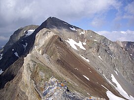
The first recorded ascension dates from 1848, by captain Loupot who was carrying out triangulation works. Of very easy access by its western slope, that of Gèdre, the summit is frequented by sheep and
285:
220:
by ascending the stream hollow of
Estaragne from the D 929, then to walk along the crest. It too, presents no major difficulty, at least not on a clear summer day.
324:
314:
309:
278:
213:
The most frequented access route runs today through the north, by a path which presents no difficulty (besides its steepness), from the Cap de Long dam.
55:
271:
319:
243:
304:
229:
98:
48:
186:
251:
122:
182:
145:
118:
216:
Another slightly shorter route, is accessible to the east : which consists in reaching the
202:
255:
138:
298:
162:
181:, culminating at a height of 3,173 m (10,410 ft). It is located in the
70:
57:
217:
25:
190:
178:
149:
126:
38:
189:
of which it constitutes the second highest summit, after the
259:
205:and has ever been ambled by shepherds and hunters.
161:
156:
137:
86:
47:
37:
32:
18:
279:
8:
286:
272:
15:
7:
240:
238:
230:List of Pyrenean three-thousanders
14:
193:(3,192 m (10,472 ft)).
105:
242:
104:
97:
24:
325:Hautes-Pyrénées geography stubs
1:
43:3,173 m (10,410 ft)
315:Landforms of Hautes-Pyrénées
310:Mountains of Hautes-Pyrénées
258:. You can help Knowledge by
341:
320:Pyrenean three-thousanders
254:geographical article is a
237:
177:is a summit in the French
305:Mountains of the Pyrenees
91:
23:
187:Pyrenees National Park
71:42.79222°N 0.11944°E
67: /
185:, included in the
33:Highest point
267:
266:
183:Néouvielle massif
171:
170:
146:Néouvielle massif
76:42.79222; 0.11944
332:
288:
281:
274:
246:
239:
141:
108:
107:
101:
82:
81:
79:
78:
77:
72:
68:
65:
64:
63:
60:
28:
16:
340:
339:
335:
334:
333:
331:
330:
329:
295:
294:
293:
292:
252:Hautes-Pyrénées
235:
226:
211:
199:
139:
133:
132:
131:
130:
129:
123:Hautes-Pyrénées
116:
115:
114:
113:
109:
75:
73:
69:
66:
61:
58:
56:
54:
53:
12:
11:
5:
338:
336:
328:
327:
322:
317:
312:
307:
297:
296:
291:
290:
283:
276:
268:
265:
264:
247:
233:
232:
225:
222:
210:
207:
198:
195:
169:
168:
167:1848 by Loupot
165:
159:
158:
154:
153:
143:
135:
134:
117:
111:
110:
103:
102:
96:
95:
94:
93:
92:
89:
88:
84:
83:
51:
45:
44:
41:
35:
34:
30:
29:
21:
20:
13:
10:
9:
6:
4:
3:
2:
337:
326:
323:
321:
318:
316:
313:
311:
308:
306:
303:
302:
300:
289:
284:
282:
277:
275:
270:
269:
263:
261:
257:
253:
248:
245:
241:
236:
231:
228:
227:
223:
221:
219:
214:
208:
206:
204:
196:
194:
192:
188:
184:
180:
176:
166:
164:
160:
155:
151:
147:
144:
142:
136:
128:
124:
120:
119:Midi-Pyrénées
100:
90:
85:
80:
52:
50:
46:
42:
40:
36:
31:
27:
22:
17:
260:expanding it
249:
234:
215:
212:
200:
174:
172:
163:First ascent
140:Parent range
74: /
49:Coordinates
299:Categories
59:42°47′32″N
218:Estaragne
175:Campbieil
112:Campbieil
87:Geography
62:0°07′10″E
39:Elevation
19:Campbieil
224:See also
191:pic Long
179:Pyrenees
157:Climbing
150:Pyrenees
197:History
209:Access
203:isards
127:France
250:This
256:stub
173:The
301::
125:,
121:,
287:e
280:t
273:v
262:.
152:)
148:(
Text is available under the Creative Commons Attribution-ShareAlike License. Additional terms may apply.