67:
20:
209:
82:
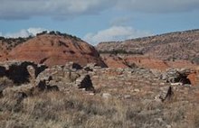
masonry, the pueblo has 22 rooms on the ground floor and may have had 6 rooms on the second story. The settlement had 37 or more additional sites, many masonry dwellings, and a
58:
The ruins are located on McKinley County Road 19, near
Tecolote Mesa. Tecolote means "owl", and the red sandstone mesa has a formation that looks like the eyes of an owl.
229:
204:
47:
214:
224:
234:
70:
Chaco Canyon and prehistoric roads. Casamero Pueblo is slightly north of 40 and east of 471. It had a road to its nearby outlier, Andrews Ranch.
75:
43:
219:
116:
165:
39:
30:
is an archaeological site including the partially excavated and stabilized ruins of an 11th-century
35:
31:
86:. Andrews Ranch, an outlier within the vicinity, was connected to the pueblo via a Chacoan road.
97:
The ruins are open throughout the year and are accessed via a short trail from the parking lot.
120:
79:
89:
Between 1966 and 1967 the pueblo was excavated. The masonry was subsequently stabilized.
198:
113:
66:
23:
Casamera Pueblo in McKinley County, New Mexico, was an outlier of Chaco Canyon.
19:
180:
167:
142:
65:
18:
83:
123:
New Mexico
Tourism Department. Retrieved August 14, 2014.
210:
Buildings and structures in McKinley County, New Mexico
143:"Casamero Pueblo | Bureau of Land Management"
8:
230:Pre-historic cities in the United States
106:
78:between about 1000 to 1125. Built with
205:Chaco Culture National Historical Park
215:Native American history of New Mexico
137:
135:
133:
131:
129:
16:Archaeological site in New Mexico, US
7:
225:Parks in McKinley County, New Mexico
74:Casamero Pueblo was an outlier of
48:Trail of the Ancients Scenic Byway
14:
235:Puebloan buildings and structures
1:
251:
181:35.426176°N 108.053635°W
119:August 21, 2014, at the
42:. It was an outlier of
186:35.426176; -108.053635
114:Trail of the Ancients.
71:
24:
220:Oasisamerica cultures
69:
22:
177: /
72:
32:Ancestral Puebloan
25:
38:, New Mexico, in
242:
192:
191:
189:
188:
187:
182:
178:
175:
174:
173:
170:
157:
156:
154:
153:
139:
124:
111:
250:
249:
245:
244:
243:
241:
240:
239:
195:
194:
185:
183:
179:
176:
171:
168:
166:
164:
163:
161:
160:
151:
149:
141:
140:
127:
121:Wayback Machine
112:
108:
103:
95:
64:
56:
46:. It is on the
40:McKinley County
28:Casamero Pueblo
17:
12:
11:
5:
248:
246:
238:
237:
232:
227:
222:
217:
212:
207:
197:
196:
159:
158:
125:
105:
104:
102:
99:
94:
91:
63:
60:
55:
52:
15:
13:
10:
9:
6:
4:
3:
2:
247:
236:
233:
231:
228:
226:
223:
221:
218:
216:
213:
211:
208:
206:
203:
202:
200:
193:
190:
148:
144:
138:
136:
134:
132:
130:
126:
122:
118:
115:
110:
107:
100:
98:
92:
90:
87:
85:
81:
77:
68:
61:
59:
53:
51:
49:
45:
41:
37:
34:community in
33:
29:
21:
162:
150:. Retrieved
146:
109:
96:
88:
76:Chaco Canyon
73:
57:
44:Chaco Canyon
27:
26:
184: /
172:108°03′13″W
147:www.blm.gov
80:core-veneer
199:Categories
169:35°25′34″N
152:2021-01-01
101:References
93:Facilities
84:Great Kiva
54:Geography
117:Archived
62:History
36:Prewitt
201::
145:.
128:^
50:.
155:.
Text is available under the Creative Commons Attribution-ShareAlike License. Additional terms may apply.