299:. The dam is 340 feet (100 m) high above the streambed, 425 feet (130 m) above the foundations, and 5,200 feet (1,600 m) long, containing 44 million cubic yards (34,000,000 m) of material. The maximum thickness of the base is 2,350 feet (720 m). Flood waters are released through an ungated, concrete overflow spillway on the west side of the dam, emptying into a stilling basin called Castaic Lagoon (colloquially referred to as the "Lower Lake", while the larger Castaic Lake is called "Upper Lake"). The total storage capacity of Castaic Lake is 325,000 acre⋅ft (401,000,000 m), of which 31,000 acre-feet (38,000,000 m) is considered active capacity and 294,000 acre-feet (363,000,000 m) are considered inactive. The inactive capacity is only used during periods of extended drought or interrupted water delivery, most recently in 2014. At maximum water elevation of 1,515 ft (462 m) AMSL, the lake covers 2,235 acres (904 ha), with 29 miles (47 km) of shoreline. The much smaller Castaic Lagoon can hold 5,560 acre⋅ft (6,860,000 m) and covers 200 acres (81 ha).
348:, before traveling through the 7.2-mile (11.6 km) Angeles Tunnel to the upper end of Castaic Lake. Together, the two reservoirs can store 505,000 acre⋅ft (623,000,000 m), or about a year's supply of water. During normal operations, Castaic Lake serves as a regulatory reservoir for water delivered through the California Aqueduct, releasing it at times of peak demand. However, the dam and lake was also built to provide a pool of "emergency storage" that can be drawn down if water deliveries from northern California are interrupted, whether due to construction, equipment malfunction or severe drought.
452:
480:
423:, located 7.2 miles (11.6 km) to the west, serves as the upper. When demand for electricity is high, usually during the afternoon, water is withdrawn from Pyramid Lake and released into Castaic Lake. At night, when demand is low, water is pumped back into Pyramid Lake. The sale of peak electricity reduces the Department of Water Resources' overall electric costs for operating the California Aqueduct.
466:
352:
1564:
32:
379:
Counties. The main customer water agencies are the
Central Basin Municipal Water District, West Basin Municipal District, and Municipal Water District of Orange County. As many as 12 million people in these areas receive their full or supplemental water supply from Castaic Lake and the feeder system.
387:
and north Los
Angeles counties, providing water to about 287,000 people. The main constituents of the agency include the Los Angeles County Waterworks District No. 36, Newhall County Water District, Santa Clara Water Division, and Valencia Water Company.
1831:
367:, where it connects to the municipal water system. The mostly underground, pre-stressed concrete pipe has walls nearly 4 feet (1.2 m) thick. Water from the Foothill Feeder is stored in the smaller
419:
separates the upper arm from the rest of
Castaic Lake, maintaining a small pool for power generation known as the Elderberry Forebay, serving as the lower reservoir of the pumped-storage operation.
1821:
843:
360:
1836:
375:. The water continues south via the 45-mile (72 km) Sepulveda Feeder, which provides water to Los Angeles proper and other municipalities in south Los Angeles and
1851:
1816:
1572:
1286:
1083:
982:
505:
420:
341:
868:
660:
899:
829:
766:
641:
798:
383:
A smaller portion of the water supply is distributed by the
Castaic Lake Water Agency. The service area covers about 195 square miles (510 km) in
1661:
495:
1535:
1517:
1474:
1028:
260:
1826:
1350:
317:
610:
576:
500:
363:. The water travels about 20 miles (32 km) south via a 16.75-foot (5.11 m) diameter pipeline to the Jensen Filtration Plant near
1443:
1019:
735:
1076:
1036:
780:
1448:
847:
1846:
1024:
61:
1527:
1092:
256:
248:
359:
Below the dam, the majority of the water flows to Los
Angeles via a system known as the Foothill Feeder, operated by the
1841:
1510:
1069:
329:
875:
1484:
1433:
1355:
1246:
1148:
687:
990:
933:
1739:
1680:
1669:
337:
1158:
1408:
1221:
1108:
376:
1469:
1423:
657:
364:
272:
1418:
1271:
1198:
1163:
1784:
1503:
1453:
1428:
1365:
1203:
1193:
805:
485:
1702:
368:
1723:
1548:
1138:
416:
1438:
1276:
1778:
1712:
1697:
1651:
1306:
1236:
336:
and eastern Los
Angeles Counties – and the West Branch, which supplies western Los Angeles and parts of
333:
1692:
1143:
1762:
1686:
1188:
1595:
1413:
1403:
1377:
1311:
617:
412:
372:
325:
313:
252:
240:
45:
1605:
1387:
1382:
1316:
1296:
1241:
1153:
1118:
675:
321:
251:, Castaic Creek provides little of its water. The lake is the terminus of the West Branch of the
232:
214:
1640:
1281:
717:
539:
400:
power plant is located at the base of the dam and generates electricity when water is needed in
312:
Castaic Lake is the lower and larger of two main storage reservoirs for the West Branch of the
1675:
1226:
1128:
893:
823:
760:
635:
572:
566:
457:
435:
742:
1646:
1620:
1479:
1345:
292:
1789:
1728:
1717:
1635:
1630:
1585:
1301:
664:
1495:
1043:
1707:
1600:
1580:
1256:
1168:
384:
284:
268:
191:
1042:. California Department of Water Resources, Division of Safety of Dams. Archived from
592:
1810:
1757:
1625:
1335:
1261:
1133:
405:
397:
244:
129:
49:
1752:
1590:
1231:
1173:
1113:
471:
176:
983:"Castaic Dam Rides Out Small Quake, But A Massive One Could Unleash A Catastrophe"
1061:
1615:
1553:
1266:
1183:
479:
401:
345:
1794:
1747:
1610:
1340:
1291:
1251:
1178:
1014:
447:
236:
76:
63:
1213:
465:
351:
264:
695:
426:
In 2009, the
Castaic pumped-storage plant generated a net 465 million KWh.
263:
and construction was completed in 1973. The lake has a capacity of 325,000
1563:
941:
220:
31:
296:
288:
914:
438:, the dam has one of the lowest safety ratings in Los Angeles County.
963:
568:
Advanced Dam
Engineering for Design, Construction, and Rehabilitation
1369:
1326:
350:
415:
is located at the upper end of the west arm of
Castaic Lake. The
1499:
1065:
1037:"Dams Within the Jurisdiction of the State of California (A-G)"
16:
Embankment dam in Los
Angeles County, California, United States
1100:
676:
http://www.lacsd.org/civica/filebank/blobdload.asp?BlobID=8666
593:"Castaic Lake The Best Places to Kayak in Southern California"
116:
328:, where it splits into the East Branch – providing water for
1832:
Buildings and structures in Los Angeles County, California
404:. In 2009, the Foothill Feeder plant generated 49 million
434:
Due to seismic vulnerabilities, and its proximity to the
844:"News from MWD: Sepulveda Feeder Shutdown : CBMWD"
571:. Springer Science & Business Media. p. 147.
1771:
1738:
1660:
1571:
1534:
1462:
1396:
1364:
1325:
1212:
1099:
934:"Hydropower License Planning and Compliance Office"
213:
208:
200:
190:
182:
172:
167:
159:
151:
143:
135:
125:
115:
110:
92:
55:
41:
24:
361:Metropolitan Water District of Southern California
324:via the California Aqueduct and pumped over the
653:
651:
155:44,000,000 cu yd (34,000,000 m)
1822:California Department of Water Resources dams
1511:
1077:
506:List of the tallest dams in the United States
8:
1518:
1504:
1496:
1084:
1070:
1062:
546:. California Department of Water Resources
21:
496:List of dams and reservoirs in California
186:325,000 acre⋅ft (401,000,000 m)
1837:Hydroelectric power plants in California
1475:California Department of Water Resources
1029:United States Department of the Interior
781:"The Center for Land Use Interpretation"
261:California Department of Water Resources
1852:Energy infrastructure completed in 1973
516:
1817:Dams in Los Angeles County, California
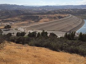
964:"CARMA - Carbon Monitoring for Action"
915:"CARMA - Carbon Monitoring for Action"
898:: CS1 maint: archived copy as title (
891:
828:: CS1 maint: archived copy as title (
821:
765:: CS1 maint: archived copy as title (
758:
688:"California State Water Project Today"
640:: CS1 maint: archived copy as title (
633:
534:
532:
530:
528:
526:
524:
522:
520:
231:is an embankment dam in northwestern
7:
981:Mcnary, Sharon (February 21, 2020).
501:List of power stations in California
1020:Geographic Names Information System
287:dam with its surfaces covered with
196:153.7 sq mi (398 km)
1351:Sacramento–San Joaquin River Delta
318:Sacramento–San Joaquin River Delta
14:
718:"California Data Exchange Center"
1662:LA Department of Water and Power
1562:
1536:CA Department of Water Resources
1444:O'Neill Pumping-Generating Plant
478:
464:
450:
267:(401,000,000 m) and stores
239:, in the unincorporated area of
30:
1025:United States Geological Survey
544:California Data Exchange Center
340:. The West Branch first enters
271:for the western portion of the
1827:California State Water Project
1528:Los Angeles County, California
1093:California State Water Project
1:
1729:Van Norman (aka San Fernando)
1573:LA Department of Public Works
19:Dam in Castaic, United States
413:Castaic Pumped-Storage Plant
147:5,200 ft (1,600 m)
1485:Bay Delta Conservation Plan
1449:Oroville–Thermalito Complex
1434:Feather River Fish Hatchery
962:Communications, Forum One.
913:Communications, Forum One.
259:. The dam was built by the
247:, a major tributary of the
98:; 51 years ago
1868:
1740:US Army Corps of Engineers
597:www.paddlingcalifornia.com
396:The 11 MW Foothill Feeder
1560:
1409:Buena Vista Pumping Plant
204:2,235 acres (904 ha)
29:
1470:CALFED Bay-Delta Program
1424:Dos Amigos Pumping Plant
1419:Devil Canyon Power Plant
1272:Little Panoche Reservoir
320:is transported down the
295:-sized rocks to prevent
273:Greater Los Angeles Area
139:340 ft (100 m)
36:View from the northeast.
1454:South Bay Pumping Plant
1429:Edmonston Pumping Plant
486:Renewable energy portal
411:The 1,495 MW (Nominal)
316:. Water drawn from the
215:Installed capacity
1847:Dams completed in 1973
932:California, State of.
716:California, State of.
417:Elderberry Forebay Dam
356:
243:. Although located on
1237:Clifton Court Forebay
369:Los Angeles Reservoir
354:
163:Uncontrolled overflow
117:Type of dam
1199:Thermalito Diversion
993:on February 24, 2020
565:R.B. Jansen (1988).
77:34.5194°N 118.6070°W
1842:Sierra Pelona Ridge
1439:Kern River Intertie
1414:Castaic Power Plant
1404:Banks Pumping Plant
1378:California Aqueduct
1329:and bodies of water
1312:Thermalito Afterbay
1277:Los Banos Reservoir
1194:Thermalito Afterbay
540:"Castaic Dam (CAS)"
373:San Fernando Valley
326:Tehachapi Mountains
314:California Aqueduct
257:State Water Project
253:California Aqueduct
192:Catchment area
183:Total capacity
73: /
1779:Brown Mountain Dam
1549:Elderberry Forebay
1388:South Bay Aqueduct
1383:North Bay Aqueduct
1317:Thermalito Forebay
1307:Tehachapi Afterbay
1297:San Luis Reservoir
1242:Elderberry Forebay
1204:Thermalito Forebay
1139:Elderberry Forebay
1015:"Castaic Lake Dam"
663:2014-07-03 at the
357:
322:San Joaquin Valley
233:Los Angeles County
160:Spillway type
82:34.5194; -118.6070
1804:
1803:
1689:(unsafe: emptied)
1683:(unsafe: emptied)
1493:
1492:
1227:Bethany Reservoir
722:cdec.water.ca.gov
578:978-0-442-24397-5
458:California portal
436:San Andreas Fault
355:The Castaic Lake.
249:Santa Clara River
226:
225:
201:Surface area
111:Dam and spillways
93:Opening date
1859:
1763:Whittier Narrows
1566:
1520:
1513:
1506:
1497:
1480:Peripheral Canal
1397:Other facilities
1346:Sacramento River
1086:
1079:
1072:
1063:
1058:
1056:
1054:
1048:
1041:
1032:
1002:
1001:
999:
998:
989:. Archived from
978:
972:
971:
959:
953:
952:
950:
949:
940:. Archived from
938:www.water.ca.gov
929:
923:
922:
910:
904:
903:
897:
889:
887:
886:
880:
874:. Archived from
873:
865:
859:
858:
856:
855:
846:. Archived from
840:
834:
833:
827:
819:
817:
816:
810:
804:. Archived from
803:
795:
789:
788:
777:
771:
770:
764:
756:
754:
753:
747:
741:. Archived from
740:
732:
726:
725:
713:
707:
706:
704:
703:
694:. Archived from
692:www.water.ca.gov
684:
678:
673:
667:
655:
646:
645:
639:
631:
629:
628:
622:
616:. Archived from
615:
607:
601:
600:
589:
583:
582:
562:
556:
555:
553:
551:
536:
488:
483:
482:
474:
469:
468:
460:
455:
454:
453:
392:Power generation
106:
104:
99:
88:
87:
85:
84:
83:
78:
74:
71:
70:
69:
66:
34:
22:
1867:
1866:
1862:
1861:
1860:
1858:
1857:
1856:
1807:
1806:
1805:
1800:
1767:
1734:
1656:
1567:
1558:
1530:
1524:
1494:
1489:
1458:
1392:
1360:
1321:
1302:Silverwood Lake
1282:O'Neill Forebay
1208:
1095:
1090:
1052:
1050:
1046:
1039:
1035:
1013:
1010:
1005:
996:
994:
980:
979:
975:
961:
960:
956:
947:
945:
931:
930:
926:
912:
911:
907:
890:
884:
882:
878:
871:
869:"Archived copy"
867:
866:
862:
853:
851:
842:
841:
837:
820:
814:
812:
808:
801:
799:"Archived copy"
797:
796:
792:
779:
778:
774:
757:
751:
749:
745:
738:
736:"Archived copy"
734:
733:
729:
715:
714:
710:
701:
699:
686:
685:
681:
674:
670:
665:Wayback Machine
656:
649:
632:
626:
624:
620:
613:
611:"Archived copy"
609:
608:
604:
591:
590:
586:
579:
564:
563:
559:
549:
547:
538:
537:
518:
514:
492:
491:
484:
477:
470:
463:
456:
451:
449:
444:
432:
394:
310:
305:
281:
152:Dam volume
102:
100:
97:
81:
79:
75:
72:
67:
64:
62:
60:
59:
37:
20:
17:
12:
11:
5:
1865:
1863:
1855:
1854:
1849:
1844:
1839:
1834:
1829:
1824:
1819:
1809:
1808:
1802:
1801:
1799:
1798:
1792:
1787:
1782:
1775:
1773:
1769:
1768:
1766:
1765:
1760:
1755:
1750:
1744:
1742:
1736:
1735:
1733:
1732:
1726:
1721:
1715:
1710:
1705:
1700:
1695:
1690:
1684:
1678:
1673:
1666:
1664:
1658:
1657:
1655:
1654:
1652:Thompson Creek
1649:
1644:
1638:
1633:
1628:
1623:
1618:
1613:
1608:
1603:
1598:
1593:
1588:
1583:
1577:
1575:
1569:
1568:
1561:
1559:
1557:
1556:
1551:
1546:
1540:
1538:
1532:
1531:
1525:
1523:
1522:
1515:
1508:
1500:
1491:
1490:
1488:
1487:
1482:
1477:
1472:
1466:
1464:
1460:
1459:
1457:
1456:
1451:
1446:
1441:
1436:
1431:
1426:
1421:
1416:
1411:
1406:
1400:
1398:
1394:
1393:
1391:
1390:
1385:
1380:
1374:
1372:
1362:
1361:
1359:
1358:
1356:San Luis Creek
1353:
1348:
1343:
1338:
1332:
1330:
1323:
1322:
1320:
1319:
1314:
1309:
1304:
1299:
1294:
1289:
1284:
1279:
1274:
1269:
1264:
1259:
1257:Lake Del Valle
1254:
1249:
1247:Frenchman Lake
1244:
1239:
1234:
1229:
1224:
1218:
1216:
1210:
1209:
1207:
1206:
1201:
1196:
1191:
1186:
1181:
1176:
1171:
1166:
1161:
1159:Little Panoche
1156:
1154:Grizzly Valley
1151:
1146:
1141:
1136:
1131:
1126:
1121:
1116:
1111:
1105:
1103:
1097:
1096:
1091:
1089:
1088:
1081:
1074:
1066:
1060:
1059:
1033:
1009:
1008:External links
1006:
1004:
1003:
973:
954:
924:
905:
860:
835:
790:
772:
727:
708:
679:
668:
647:
602:
584:
577:
557:
515:
513:
510:
509:
508:
503:
498:
490:
489:
475:
461:
446:
445:
443:
440:
431:
428:
406:kilowatt hours
393:
390:
338:Ventura County
334:San Bernardino
309:
306:
304:
301:
283:Castaic is an
280:
277:
269:drinking water
255:, part of the
224:
223:
217:
211:
210:
206:
205:
202:
198:
197:
194:
188:
187:
184:
180:
179:
174:
170:
169:
165:
164:
161:
157:
156:
153:
149:
148:
145:
141:
140:
137:
133:
132:
127:
123:
122:
119:
113:
112:
108:
107:
94:
90:
89:
57:
53:
52:
43:
39:
38:
35:
27:
26:
18:
15:
13:
10:
9:
6:
4:
3:
2:
1864:
1853:
1850:
1848:
1845:
1843:
1840:
1838:
1835:
1833:
1830:
1828:
1825:
1823:
1820:
1818:
1815:
1814:
1812:
1796:
1793:
1791:
1788:
1786:
1783:
1780:
1777:
1776:
1774:
1770:
1764:
1761:
1759:
1756:
1754:
1751:
1749:
1746:
1745:
1743:
1741:
1737:
1730:
1727:
1725:
1722:
1719:
1716:
1714:
1711:
1709:
1706:
1704:
1701:
1699:
1696:
1694:
1691:
1688:
1685:
1682:
1679:
1677:
1674:
1671:
1670:Baldwin Hills
1668:
1667:
1665:
1663:
1659:
1653:
1650:
1648:
1645:
1642:
1639:
1637:
1634:
1632:
1629:
1627:
1624:
1622:
1619:
1617:
1614:
1612:
1609:
1607:
1604:
1602:
1599:
1597:
1594:
1592:
1589:
1587:
1584:
1582:
1579:
1578:
1576:
1574:
1570:
1565:
1555:
1552:
1550:
1547:
1545:
1542:
1541:
1539:
1537:
1533:
1529:
1521:
1516:
1514:
1509:
1507:
1502:
1501:
1498:
1486:
1483:
1481:
1478:
1476:
1473:
1471:
1468:
1467:
1465:
1461:
1455:
1452:
1450:
1447:
1445:
1442:
1440:
1437:
1435:
1432:
1430:
1427:
1425:
1422:
1420:
1417:
1415:
1412:
1410:
1407:
1405:
1402:
1401:
1399:
1395:
1389:
1386:
1384:
1381:
1379:
1376:
1375:
1373:
1371:
1367:
1363:
1357:
1354:
1352:
1349:
1347:
1344:
1342:
1339:
1337:
1336:Feather River
1334:
1333:
1331:
1328:
1324:
1318:
1315:
1313:
1310:
1308:
1305:
1303:
1300:
1298:
1295:
1293:
1290:
1288:
1285:
1283:
1280:
1278:
1275:
1273:
1270:
1268:
1265:
1263:
1262:Lake Oroville
1260:
1258:
1255:
1253:
1250:
1248:
1245:
1243:
1240:
1238:
1235:
1233:
1230:
1228:
1225:
1223:
1222:Antelope Lake
1220:
1219:
1217:
1215:
1211:
1205:
1202:
1200:
1197:
1195:
1192:
1190:
1187:
1185:
1182:
1180:
1177:
1175:
1172:
1170:
1167:
1165:
1164:Los Banos Dam
1162:
1160:
1157:
1155:
1152:
1150:
1147:
1145:
1142:
1140:
1137:
1135:
1132:
1130:
1129:Cedar Springs
1127:
1125:
1122:
1120:
1117:
1115:
1112:
1110:
1107:
1106:
1104:
1102:
1098:
1094:
1087:
1082:
1080:
1075:
1073:
1068:
1067:
1064:
1049:on 2012-03-09
1045:
1038:
1034:
1030:
1026:
1022:
1021:
1016:
1012:
1011:
1007:
992:
988:
984:
977:
974:
969:
965:
958:
955:
944:on 2013-11-03
943:
939:
935:
928:
925:
920:
916:
909:
906:
901:
895:
881:on 2012-10-14
877:
870:
864:
861:
850:on 2014-07-14
849:
845:
839:
836:
831:
825:
811:on 2014-07-14
807:
800:
794:
791:
786:
782:
776:
773:
768:
762:
748:on 2014-07-14
744:
737:
731:
728:
723:
719:
712:
709:
698:on 2010-09-01
697:
693:
689:
683:
680:
677:
672:
669:
666:
662:
659:
654:
652:
648:
643:
637:
623:on 2017-11-06
619:
612:
606:
603:
598:
594:
588:
585:
580:
574:
570:
569:
561:
558:
545:
541:
535:
533:
531:
529:
527:
525:
523:
521:
517:
511:
507:
504:
502:
499:
497:
494:
493:
487:
481:
476:
473:
467:
462:
459:
448:
441:
439:
437:
429:
427:
424:
422:
418:
414:
409:
407:
403:
399:
398:hydroelectric
391:
389:
386:
381:
378:
374:
370:
366:
362:
353:
349:
347:
343:
339:
335:
331:
327:
323:
319:
315:
307:
302:
300:
298:
294:
290:
286:
278:
276:
274:
270:
266:
262:
258:
254:
250:
246:
245:Castaic Creek
242:
238:
234:
230:
222:
218:
216:
212:
209:Power Station
207:
203:
199:
195:
193:
189:
185:
181:
178:
175:
171:
166:
162:
158:
154:
150:
146:
142:
138:
134:
131:
130:Castaic Creek
128:
124:
120:
118:
114:
109:
95:
91:
86:
58:
54:
51:
50:United States
47:
44:
40:
33:
28:
23:
1785:Las Virgenes
1724:Stone Canyon
1647:Sierra Madre
1621:Puddingstone
1596:Devil's Gate
1543:
1287:Pyramid Lake
1232:Castaic Lake
1144:Fish Barrier
1123:
1051:. Retrieved
1044:the original
1018:
995:. Retrieved
991:the original
986:
976:
967:
957:
946:. Retrieved
942:the original
937:
927:
918:
908:
883:. Retrieved
876:the original
863:
852:. Retrieved
848:the original
838:
813:. Retrieved
806:the original
793:
785:www.clui.org
784:
775:
750:. Retrieved
743:the original
730:
721:
711:
700:. Retrieved
696:the original
691:
682:
671:
658:Castaic Lake
625:. Retrieved
618:the original
605:
596:
587:
567:
560:
548:. Retrieved
543:
472:Water portal
433:
425:
421:Pyramid Lake
410:
395:
382:
365:San Fernando
358:
344:, formed by
342:Pyramid Lake
311:
308:Water supply
282:
228:
227:
177:Castaic Lake
1790:Little Rock
1718:St. Francis
1713:Silver Lake
1703:Los Angeles
1636:Santa Anita
1631:San Gabriel
1586:Big Tujunga
1267:Lake Perris
1053:December 3,
402:Los Angeles
346:Pyramid Dam
229:Castaic Dam
80: /
68:118°36′25″W
56:Coordinates
25:Castaic Dam
1811:Categories
1708:Mulholland
1687:Dry Canyon
1681:Chatsworth
1601:Eaton Wash
1581:Big Dalton
1341:Piru Creek
1292:Quail Lake
1252:Lake Davis
1214:Reservoirs
1189:Quail Lake
997:2020-02-24
948:2014-06-06
885:2014-06-06
854:2014-06-06
815:2014-06-06
752:2014-06-06
702:2014-06-06
627:2014-06-08
512:References
303:Operations
285:earth-fill
279:Dimensions
237:California
65:34°31′10″N
1797:(disused)
1781:(disused)
1758:Sepulveda
1643:(disused)
1626:San Dimas
1366:Aqueducts
1149:Frenchman
1134:Del Valle
1114:B.F. Sisk
968:carma.org
919:carma.org
330:Riverside
265:acre-feet
168:Reservoir
121:Earthfill
1753:Santa Fe
1731:(failed)
1720:(failed)
1698:Fairmont
1672:(failed)
1606:Live Oak
1591:Cogswell
1526:Dams in
1174:Oroville
1109:Antelope
894:cite web
824:cite web
761:cite web
661:Archived
636:cite web
442:See also
289:boulders
126:Impounds
42:Location
1676:Bouquet
1616:Pacoima
1554:Pyramid
1544:Castaic
1463:Related
1184:Pyramid
1169:O'Neill
1124:Castaic
1119:Bethany
408:(KWh).
385:Ventura
371:in the
297:erosion
241:Castaic
173:Creates
101: (
46:Castaic
1795:Rindge
1748:Hansen
1693:Encino
1641:Sawpit
1611:Morris
1370:canals
1327:Rivers
1179:Perris
575:
550:6 June
430:Safety
377:Orange
293:cobble
144:Length
136:Height
1772:Other
1047:(PDF)
1040:(PDF)
987:LAist
879:(PDF)
872:(PDF)
809:(PDF)
802:(PDF)
746:(PDF)
739:(PDF)
621:(PDF)
614:(PDF)
1368:and
1101:Dams
1055:2012
900:link
830:link
767:link
642:link
573:ISBN
552:2014
332:and
291:and
103:1973
96:1973
219:11
1813::
1027:,
1023:.
1017:.
985:.
966:.
936:.
917:.
896:}}
892:{{
826:}}
822:{{
783:.
763:}}
759:{{
720:.
690:.
650:^
638:}}
634:{{
595:.
542:.
519:^
275:.
235:,
221:MW
48:,
1519:e
1512:t
1505:v
1085:e
1078:t
1071:v
1057:.
1031:.
1000:.
970:.
951:.
921:.
902:)
888:.
857:.
832:)
818:.
787:.
769:)
755:.
724:.
705:.
644:)
630:.
599:.
581:.
554:.
105:)
Text is available under the Creative Commons Attribution-ShareAlike License. Additional terms may apply.