34:
50:
399:
433:, and was part of its ecclesiastical parish, though part of Castle Camps for feudal purposes. It was included as part of Essex in the Risbridge poor-law union in the 19th century, and also sometimes listed as the Cambridgeshire part of Helions Bumpstead parish. The situation was only resolved in 1885 when it was transferred to Castle Camps for all civil purposes.
57:
219:
500:
Castle Camps also has its own primary school. The schoolroom was first built in 1866, when there were 96 pupils, and the building was extended in 1876 and again in 1886. Numbers rose to a peak of 160 in the 1880s, falling to 107 in 1914 and 75 by the 1930s. Pupils of secondary age were transferred to
484:
about 13 miles (21 km) to the west of Castle Camps. However, as Great
Chishill was historically a part of Essex (having been moved in boundary changes in 1895), the historic county top of Cambridgeshire is close to Castle Camps, where a point on the disused RAF airfield reaches a height of 128
464:
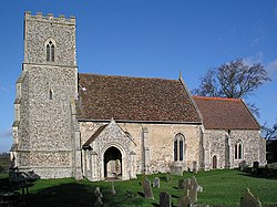
There has been a church in Castle Camps since at least the start of the 12th century. The present parish church, dedicated to All Saints since the 15th century, comprises a chancel, nave with south porch, and west tower. Situated to the north-west of the castle, the building largely dates from the
497:, The Oak (formerly The Cock but renamed in April 2019), situated on the High Street. There were two alehouses licensed in Castle Camps in 1682, and in 1800 there were 2 pubs – The George, which closed around 1910, and The Oak. The New Inn opened prior to 1871 and closed in the late 20th century.
537:
414:
with the former following the line of the ancient woodland that separated the counties, and the latter probably representing the extent of the fence around the Castle. It also borders
267:
259:
123:
96:
243:
697:
303:
49:
205:
472:
was rector of the parish in the mid-19th century, and is known for writing the hymn "O Jesus I have
Promised". He is buried in the church yard.
702:
236:
410:. Roughly triangular in shape, it covers an area of 3,198 acres (1,294 ha). Its south-western and south-eastern borders separate it from
614:
563:
692:
468:
The medieval tower collapsed in 1850, with a replacement completed in 1851. Extensive refurbishment continued through the 19th century.
231:
480:
The highest point of the current administrative county of
Cambridgeshire, 479 feet (146 m) above sea level, is in the village of
448:
station on the plateau to the south-east of the castle. Established in
September 1939, RAF Castle Camps operated as a satellite for
248:
295:
285:
193:
159:
456:
and numerous squadrons flew from the airfield until its closure in
January 1946. The land was sold between 1963 and 1966.
33:
89:
224:
290:
173:
502:
425:
The hamlet of
Olmstead in the south-eastern corner of the parish was sometimes listed as being part of
650:
517:
465:
15th and 16th century, though elements of the chancel walls may have been built in the 14th century.
344:
113:
105:
639:
618:
567:
364:
141:
662:
426:
598:
469:
437:
198:
453:
149:
481:
407:
348:
131:
70:
686:
494:
379:
340:
367:. The population of the parish (including Camps End) was 684 at the 2011 Census.
441:
415:
449:
318:
305:
398:
352:
183:
419:
356:
165:
485:
metres (420 ft) above sea level (grid reference TL 63282 41881).
387:
383:
406:
The parish of Castle Camps lies in the very south-eastern corner of
651:
http://www.hill-bagging.co.uk/mountaindetails.php?qu=S&rf=18929
430:
411:
397:
360:
677:
445:
508:
A building was bought to become the village hall in 1952.
600:
A History of the County of
Cambridge and the Isle of Ely
653:, Hill bagging website (Castle Camps Airfield summit)
351:, England. It is 15 miles (24 km) south-east of
258:
242:
230:
218:
204:
192:
182:
172:
158:
140:
122:
104:
88:
80:
26:
617:. The Village of Castle Camps. Archived from
566:. The Village of Castle Camps. Archived from
8:
593:
591:
589:
587:
585:
23:
418:to the north and has a short border with
440:, Castle Camps, like may other parts of
529:
257:
213:
181:
157:
87:
30:
241:
229:
217:
203:
191:
171:
139:
121:
103:
7:
603:. Vol. 6. 1978. pp. 36–48.
56:
16:Village and civil parish in England
663:The History of Castle Camps School
14:
698:Civil parishes in Cambridgeshire
544:. Office for National Statistics
55:
48:
32:
538:"Civil Parish population 2011"
1:
703:South Cambridgeshire District
378:, the village is named after
355:and near to the borders of
347:district, in the county of
90:OS grid reference
21:Human settlement in England
719:
693:Villages in Cambridgeshire
276:
268:Cambridgeshire South East
254:
214:
43:
31:
615:"History - The Airfield"
542:Neighbourhood Statistics
402:Signpost in Castle Camps
564:"History - The Village"
503:Linton Village College
403:
194:Postcode district
401:
518:The Hundred Parishes
493:The village has one
345:South Cambridgeshire
319:52.06335°N 0.37981°E
174:Sovereign state
114:South Cambridgeshire
621:on 20 February 2007
570:on 20 February 2007
422:to the north-west.
363:and to the town of
315: /
404:
260:UK Parliament
206:Dialling code
640:All Saints Church
476:County High Point
427:Helions Bumpstead
370:Previously named
339:is a village and
334:
333:
324:52.06335; 0.37981
124:Shire county
710:
665:
660:
654:
648:
642:
637:
631:
630:
628:
626:
611:
605:
604:
595:
580:
579:
577:
575:
560:
554:
553:
551:
549:
534:
501:the newly built
470:John Ernest Bode
444:, was home to a
438:Second World War
330:
329:
327:
326:
325:
320:
316:
313:
312:
311:
308:
282:
168:
100:
99:
69:Location within
59:
58:
52:
36:
24:
718:
717:
713:
712:
711:
709:
708:
707:
683:
682:
678:Village website
674:
669:
668:
661:
657:
649:
645:
638:
634:
624:
622:
613:
612:
608:
597:
596:
583:
573:
571:
562:
561:
557:
547:
545:
536:
535:
531:
526:
514:
491:
478:
462:
454:RAF North Weald
396:
390:'s boundaries.
323:
321:
317:
314:
309:
306:
304:
302:
301:
300:
280:
272:
249:East of England
164:
154:
136:
118:
95:
94:
84:684 (2011)
76:
75:
74:
73:
67:
66:
65:
64:
60:
39:
22:
17:
12:
11:
5:
716:
714:
706:
705:
700:
695:
685:
684:
681:
680:
673:
672:External links
670:
667:
666:
655:
643:
632:
606:
581:
555:
528:
527:
525:
522:
521:
520:
513:
510:
490:
487:
482:Great Chishill
477:
474:
461:
458:
408:Cambridgeshire
395:
392:
349:Cambridgeshire
332:
331:
299:
298:
296:Cambridgeshire
293:
288:
283:
281:List of places
277:
274:
273:
271:
270:
264:
262:
256:
255:
252:
251:
246:
240:
239:
237:Cambridgeshire
234:
228:
227:
225:Cambridgeshire
222:
216:
215:
212:
211:
208:
202:
201:
196:
190:
189:
186:
180:
179:
178:United Kingdom
176:
170:
169:
162:
156:
155:
153:
152:
146:
144:
138:
137:
135:
134:
132:Cambridgeshire
128:
126:
120:
119:
117:
116:
110:
108:
102:
101:
92:
86:
85:
82:
78:
77:
71:Cambridgeshire
68:
62:
61:
54:
53:
47:
46:
45:
44:
41:
40:
37:
29:
28:
20:
15:
13:
10:
9:
6:
4:
3:
2:
715:
704:
701:
699:
696:
694:
691:
690:
688:
679:
676:
675:
671:
664:
659:
656:
652:
647:
644:
641:
636:
633:
620:
616:
610:
607:
602:
601:
594:
592:
590:
588:
586:
582:
569:
565:
559:
556:
543:
539:
533:
530:
523:
519:
516:
515:
511:
509:
506:
504:
498:
496:
488:
486:
483:
475:
473:
471:
466:
459:
457:
455:
451:
447:
443:
439:
434:
432:
428:
423:
421:
417:
413:
409:
400:
393:
391:
389:
385:
381:
377:
373:
368:
366:
362:
358:
354:
350:
346:
342:
338:
328:
297:
294:
292:
289:
287:
284:
279:
278:
275:
269:
266:
265:
263:
261:
253:
250:
247:
245:
238:
235:
233:
226:
223:
221:
209:
207:
200:
197:
195:
187:
185:
177:
175:
167:
163:
161:
151:
148:
147:
145:
143:
133:
130:
129:
127:
125:
115:
112:
111:
109:
107:
98:
93:
91:
83:
79:
72:
51:
42:
35:
25:
19:
658:
646:
635:
623:. Retrieved
619:the original
609:
599:
572:. Retrieved
568:the original
558:
546:. Retrieved
541:
532:
507:
499:
495:public house
492:
479:
467:
463:
435:
424:
405:
380:Castle Camps
375:
371:
369:
341:civil parish
337:Castle Camps
336:
335:
63:Castle Camps
27:Castle Camps
18:
625:20 February
574:20 February
442:East Anglia
436:During the
416:Shudy Camps
386:within the
376:Camps Green
372:Great Camps
322: /
687:Categories
524:References
450:RAF Debden
307:52°03′48″N
81:Population
38:All Saints
505:in 1937.
489:Amenities
365:Haverhill
353:Cambridge
310:0°22′47″E
244:Ambulance
188:CAMBRIDGE
184:Post town
512:See also
106:District
97:TL632432
548:14 July
420:Bartlow
394:History
357:Suffolk
343:in the
291:England
166:England
160:Country
460:Church
388:parish
384:castle
382:, the
220:Police
142:Region
431:Essex
412:Essex
361:Essex
210:01799
627:2008
576:2008
550:2016
452:and
374:and
359:and
232:Fire
199:CB21
150:East
446:RAF
429:in
689::
584:^
540:.
286:UK
629:.
578:.
552:.
Text is available under the Creative Commons Attribution-ShareAlike License. Additional terms may apply.