315:
389:
105:
112:
417:
405:
377:
338:) sup." climbing skills, a rate that indicates "small difficulties requiring the use of the rope" ). From the platform on the east face where the "hole" opens, a ledge crosses the north ridge, then returns to the west face towards a chimney (vertical fracture, listed II) which is climbed 12 metres (39 ft) up to near the summit ridge, to finish with a short climb (vertical slab, grade III) to the summit.
29:
365:
741:
290:
later, when the devil reappeared the village head gave his agreement but the bridge had to be completely built in one night, that is to say, before the rooster crowed. The satanic engineer set to work, all night long a dreadful din was heard near the Golo, the bridge was almost finished as the thousands of devils called by Satan to his aid had put ardor into their work.
314:
294:
crow. A cry of rage came from the ranks of the workers of hell. In turn, the devil let out a terrible roar and threw his useless tool into the air. The hammer struck the "Capo
Tafonato", (the holed mountain) which it passed through from side to side. And this is how the devil's hole was dug, at the precise moment when Lucifer disappeared.
797:
285:
was tending the flocks in the meadows of Niolo, he received a visit from a stranger who asked him to enter his service. The latter seemed needy, so the saint hired him. During the first night when he shared his hut with his servant, he noticed that he gave off a strong smell of sulfur while sleeping.
307:
The normal route "ranks at the upper limit of what non-climbers can face". It begins at the
Moorish Pass and uses a system of low-sloping rocky outcrops (vires) that run on the east face of Capu Tafunatu: first to the south and then over whitish rocks, heading north to the plateau where the cavity
293:
In the midst of this darkness made feverish by the infernal tumult, a man walked calmly and peacefully, and contemplated the work carried out. Only one stone remained to be laid, the keystone of the Bridge. Then the man pulled out a rooster from under his coat. The rooster stretched and began to
289:
The devil, who knew well how to disguise his wicked person, went to find the head of the village of Niolo. He offered to build him a bridge over the Golo in exchange for the ownership of a soul to be chosen from his village. But the village head went to seek advice from Saint Martin. A few hours
303:
Different routes allow the ascent to the "hole" of Capu
Tafunatu, at about 2,200 metres (7,200 ft), from the refuge of Ciottulu a i Mori. All require great caution (risk of fatal falls) but remain practicable without special equipment for people in good physical condition and not prone to
286:
The next morning, Martin told the shepherd that he had guessed his true identity and that he could not keep him in his service. The devil flew into a violent rage. So he went away, determined to stay in the area and give Saint Martin a formidable competitor.
257:
The formation of the "hole" is explained by tectonics. The inclined plane at the base of this cavity is an oblique fault which, intersecting the rocky blade of the summit, weakened it and caused it to collapse.
234:
Capu
Tafunatu literally means "perforated head". The top of the mountain is pierced by an opening 55 metres (180 ft) wide by 16 metres (52 ft), making it the largest natural arch in France.
566:
388:
724:
416:
320:
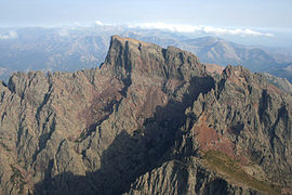
Panoramic photo of Capu
Tafunatu (east face, in the shade) and the Col des Maures (Moorish Pass), above the Ciottulu a i Mori refuge in the upper
702:
104:
717:
266:
638:
620:
1013:
376:
1006:
1035:
710:
61:
404:
364:
996:
937:
54:
932:
593:
349:: Very difficult) climb the east and west faces. Their approach is respectively from the Col des Maures and the
781:
273:(History and Theory of the Earth), hypothesizes that Corsica is a mountain peak of the sunken continent of
952:
766:
648:
957:
942:
776:
977:
826:
786:
771:
324:
Valley. One can distinguish in the wall the turns of the normal access route leading to the "hole".
972:
962:
947:
831:
761:
334:
Access to the main summit of Capu
Tafunatu, altitude 2,335 metres (7,661 ft), requires "PD (
224:
216:
168:
156:
876:
756:
663:
634:
616:
982:
922:
250:
facies, an igneous rock of the Monte Cinto annular volcano-plutonic complex, formed in the
811:
282:
967:
917:
856:
851:
149:
1029:
871:
395:
350:
28:
927:
896:
891:
881:
866:
846:
649:"Le Capu Tavunatu (Haute Corse), un essai brésilien naturel en tectonique cassante"
321:
186:
681:
656:
Travaux scientifiques du parc naturel régional et des réserves naturelles de Corse
886:
861:
841:
816:
734:
220:
204:
142:
584:
211:, France. It rises to an altitude of 2,335 metres (7,661 ft) in the Niolo
901:
836:
423:
247:
228:
667:
76:
63:
456:
454:
274:
243:
174:
251:
208:
44:
796:
615:, Cartes et guides de Corse, Grenoble: Didier Richard, p. 408,
441:
439:
613:
Guide des montagnes corses : Randonnées pédestres et escalades
706:
682:"Carte géologique de la France à 1/50000 : Galeria-Osani"
521:
519:
517:
460:
680:
Vellutini, P.J.; Rossi, P-; Michon, G.; Hervé, J.Y (1996),
193:
Northern ridge from the refuge de Ciòttulu à i Mori (PD +)
472:
445:
422:
Capu
Tafunatu to the right of Paglia Orba seen from
910:
804:
749:
382:
The arch of Capu
Tafunatu seen from the Paglia Orba
185:
180:
167:
162:
148:
138:
130:
92:
53:
43:
38:
21:
277:. It was at this time that this legend was told:
484:
215:in the northwest of the island. Located in the
279:
633:, Aiacciu i.e. Ajaccio: Albiana, p. 232,
370:Paglia Orba (center) and Capu Tafunatu (right)
718:
8:
647:Souffache, Blaise; Gauthier, Alain (1993),
594:"De nouveaux relevés métriques au Tafunatu"
725:
711:
703:
18:
549:
537:
525:
508:
16:Mountain on the island of Corsica, France
496:
435:
360:
310:
267:Georges-Louis Leclerc, Comte de Buffon
398:Valley from the arch of Capu Tafunatu
111:
7:
410:Capu Tafunatu (left) and Paglia Orba
341:Several climbing routes rated “AD” (
33:West face of Capu Tafunatu in winter
242:Capu Tafunatu consists of alkaline
203:is a mountain in the department of
14:
795:
739:
415:
403:
387:
375:
363:
313:
110:
103:
27:
461:De nouveaux relevés métriques..
271:Histoire et théorie de la terre
227:on the edge of the commune of
1:
600:(in French), 6 September 2010
485:Souffache & Gauthier 1993
345:: Fairly difficult) to “TD" (
49:2,335 m (7,661 ft)
631:Corse, l'Élysée du Géologue
1052:
611:Fabrikant, Michel (1982),
446:Capu Tafunatum, Géoportail
991:
793:
97:
26:
1036:Mountains of Haute-Corse
629:Gauthier, Alain (2015),
223:, it rises southeast of
296:
473:Vellutini et al. 1996
77:42.34083°N 8.86833°E
552:, pp. 212–220.
528:, pp. 209–211.
73: /
832:Cima di e Follicie
262:In popular culture
217:Monte Cintu massif
157:Monte Cinto massif
39:Highest point
1023:
1022:
877:Monte San Petrone
782:Monte San Petrone
733:Landforms of the
691:(in French), BRGM
640:978-2-8241-0632-8
622:978-2-7038-0018-7
281:At the time when
207:on the island of
197:
196:
82:42.34083; 8.86833
1043:
799:
744:
743:
742:
727:
720:
713:
704:
698:
697:
696:
686:
676:
675:
674:
653:
643:
625:
607:
606:
605:
589:
580:
579:
578:
553:
547:
541:
535:
529:
523:
512:
506:
500:
494:
488:
482:
476:
470:
464:
458:
449:
443:
419:
407:
391:
379:
367:
317:
269:(1707–1788), in
189:
152:
114:
113:
107:
88:
87:
85:
84:
83:
78:
74:
71:
70:
69:
66:
31:
19:
1051:
1050:
1046:
1045:
1044:
1042:
1041:
1040:
1026:
1025:
1024:
1019:
1018:
987:
906:
812:Capo al Berdato
800:
791:
745:
740:
738:
731:
701:
694:
692:
684:
679:
672:
670:
651:
646:
641:
628:
623:
610:
603:
601:
592:
583:
576:
574:
567:"Capu Tafunatu"
565:
561:
556:
548:
544:
536:
532:
524:
515:
507:
503:
495:
491:
483:
479:
471:
467:
459:
452:
444:
437:
433:
426:
420:
411:
408:
399:
392:
383:
380:
371:
368:
359:
343:Assez difficile
332:
325:
318:
301:
264:
240:
187:
150:
126:
125:
124:
123:
122:
121:
120:
119:
115:
81:
79:
75:
72:
67:
64:
62:
60:
59:
34:
17:
12:
11:
5:
1049:
1047:
1039:
1038:
1028:
1027:
1021:
1020:
1017:
1016:
1011:
1010:
1009:
999:
993:
992:
989:
988:
986:
985:
980:
975:
970:
965:
960:
955:
950:
945:
940:
935:
930:
925:
920:
914:
912:
908:
907:
905:
904:
899:
894:
889:
884:
879:
874:
869:
864:
859:
854:
852:Monte Incudine
849:
844:
839:
834:
829:
824:
819:
814:
808:
806:
802:
801:
794:
792:
790:
789:
784:
779:
774:
769:
767:Monte Incudine
764:
759:
753:
751:
747:
746:
732:
730:
729:
722:
715:
707:
700:
699:
677:
644:
639:
626:
621:
608:
590:
581:
562:
560:
557:
555:
554:
550:Fabrikant 1982
542:
538:Fabrikant 1982
530:
526:Fabrikant 1982
513:
501:
489:
477:
465:
450:
434:
432:
429:
428:
427:
421:
414:
412:
409:
402:
400:
393:
386:
384:
381:
374:
372:
369:
362:
358:
355:
347:Très difficile
331:
328:
327:
326:
319:
312:
300:
297:
263:
260:
239:
236:
195:
194:
191:
183:
182:
178:
177:
171:
165:
164:
160:
159:
154:
146:
145:
140:
136:
135:
132:
128:
127:
117:
116:
109:
108:
102:
101:
100:
99:
98:
95:
94:
90:
89:
57:
51:
50:
47:
41:
40:
36:
35:
32:
24:
23:
15:
13:
10:
9:
6:
4:
3:
2:
1048:
1037:
1034:
1033:
1031:
1015:
1012:
1008:
1005:
1004:
1003:
1000:
998:
995:
994:
990:
984:
981:
979:
976:
974:
971:
969:
966:
964:
961:
959:
958:Santo Stefano
956:
954:
951:
949:
946:
944:
943:San Colombano
941:
939:
936:
934:
933:Saint-Antoine
931:
929:
926:
924:
921:
919:
916:
915:
913:
909:
903:
900:
898:
895:
893:
890:
888:
885:
883:
880:
878:
875:
873:
872:Monte Rotondo
870:
868:
865:
863:
860:
858:
855:
853:
850:
848:
845:
843:
840:
838:
835:
833:
830:
828:
827:Cima a i Mori
825:
823:
822:Capu Tafunatu
820:
818:
815:
813:
810:
809:
807:
803:
798:
788:
785:
783:
780:
778:
777:Monte Rotondo
775:
773:
770:
768:
765:
763:
760:
758:
755:
754:
752:
748:
736:
728:
723:
721:
716:
714:
709:
708:
705:
690:
683:
678:
669:
665:
661:
658:(in French),
657:
650:
645:
642:
636:
632:
627:
624:
618:
614:
609:
599:
595:
591:
588:
587:
586:Culture Corse
582:
572:
568:
564:
563:
558:
551:
546:
543:
539:
534:
531:
527:
522:
520:
518:
514:
510:
509:Culture Corse
505:
502:
499:, p. 61.
498:
497:Gauthier 2015
493:
490:
486:
481:
478:
475:, p. 57.
474:
469:
466:
462:
457:
455:
451:
447:
442:
440:
436:
430:
425:
418:
413:
406:
401:
397:
390:
385:
378:
373:
366:
361:
356:
354:
352:
348:
344:
339:
337:
336:peu difficile
329:
323:
316:
311:
309:
305:
298:
295:
291:
287:
284:
278:
276:
272:
268:
261:
259:
255:
253:
249:
245:
237:
235:
232:
230:
226:
222:
218:
214:
210:
206:
202:
201:Capu Tafunatu
192:
190:
188:Easiest route
184:
179:
176:
172:
170:
166:
161:
158:
155:
153:
147:
144:
141:
137:
133:
129:
118:Capu Tafunatu
106:
96:
91:
86:
58:
56:
52:
48:
46:
42:
37:
30:
25:
22:Capu Tafunatu
20:
1007:Corse-du-Sud
1001:
938:Sainte-Marie
897:Punta Minuta
892:Punta Artica
882:Monte Stello
867:Monte Renoso
847:Monte Grosso
821:
787:Monte Stello
772:Monte Renoso
693:, retrieved
688:
671:, retrieved
659:
655:
630:
612:
602:, retrieved
597:
585:
575:, retrieved
570:
545:
540:, p. 8.
533:
504:
492:
480:
468:
346:
342:
340:
335:
333:
306:
302:
292:
288:
283:Saint Martin
280:
270:
265:
256:
241:
233:
212:
200:
198:
169:Type of rock
151:Parent range
1014:Waterbodies
953:Santa Lucia
948:San Quilico
887:Paglia Orba
862:Monte Padro
857:Monte d'Oro
842:Monte Cinto
817:Capu Biancu
762:Monte Cinto
737:department
735:Haute-Corse
598:Corse Matin
573:(in French)
221:Paglia Orba
205:Haute-Corse
143:Haute-Corse
80: /
55:Coordinates
902:San Parteo
837:Monte Astu
757:Monte Astu
695:2022-02-08
673:2022-02-08
604:2022-02-08
577:2022-02-08
571:Géoportail
248:ignimbrite
229:Albertacce
139:Department
65:42°20′27″N
1002:Landforms
983:Vizzavona
923:Marsolino
689:Infoterre
668:0246-1579
662:: 63–86,
304:vertigo.
219:near the
93:Geography
68:8°52′06″E
45:Elevation
1030:Category
997:Communes
353:valley.
330:Climbing
275:Atlantis
244:rhyolite
181:Climbing
175:rhyolite
968:Teghime
918:Bigorno
750:Massifs
559:Sources
424:Galéria
357:Gallery
308:opens.
252:Permian
238:Geology
209:Corsica
173:Rocks:
163:Geology
131:Country
978:Vergio
911:Passes
666:
637:
619:
299:Access
134:France
973:Verde
963:Sorba
928:Prato
805:Peaks
685:(PDF)
652:(PDF)
431:Notes
396:Fango
351:Fango
246:with
225:Manso
213:piève
664:ISSN
635:ISBN
617:ISBN
394:The
322:Golo
199:The
1032::
687:,
660:41
654:,
596:,
569:,
516:^
453:^
438:^
254:.
231:.
726:e
719:t
712:v
511:.
487:.
463:.
448:.
Text is available under the Creative Commons Attribution-ShareAlike License. Additional terms may apply.