28:
40:
79:
on the east. The lowland areas are either flat or consist of gently rolling hills. The 25-mile long Caroni river flows westward through the Caroni Plain and drains into the
87:
coast. The Caroni Plain was a major region of sugar and cocoa production in the 18th and 19th centuries and the first half of the 20th century.
167:
68:
27:
56:
172:
144:, American University (Washington, D.C.). Foreign Area Studies, Supt. of Docs., U.S. Govt. Print. Off.
101:
72:
64:
39:
161:
84:
44:
96:
80:
76:
139:
17:
52:
32:
26:
71:. The lowland areas to the south of the Central Range are the
43:
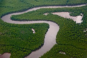
Aerial view of the Caroni Swamp on the northwestern
118:
116:
8:
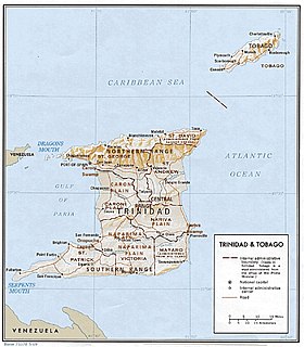
35:, showing the Caroni Plain in the northwest
38:
112:
141:Area handbook for Trinidad and Tobago
122:
7:
25:
57:Republic of Trinidad and Tobago
63:is a lowland area between the
1:
168:Plains of Trinidad and Tobago
138:Black, Jan Knippers (1976),
189:
31:Physical relief map of
48:
36:
42:
30:
75:on the west and the
49:
37:
173:Trinidad (island)
51:On the island of
47:coast of Trinidad
16:(Redirected from
180:
152:
151:
149:
126:
120:
21:
188:
187:
183:
182:
181:
179:
178:
177:
158:
157:
147:
145:
137:
134:
129:
121:
114:
110:
93:
23:
22:
15:
12:
11:
5:
186:
184:
176:
175:
170:
160:
159:
154:
153:
133:
130:
128:
127:
111:
109:
106:
105:
104:
102:Southern Range
99:
92:
89:
73:Naparima Plain
65:Northern Range
24:
14:
13:
10:
9:
6:
4:
3:
2:
185:
174:
171:
169:
166:
165:
163:
156:
143:
142:
136:
135:
131:
124:
119:
117:
113:
107:
103:
100:
98:
95:
94:
90:
88:
86:
85:Gulf of Paria
82:
78:
74:
70:
69:Central Range
66:
62:
58:
54:
46:
45:Gulf of Paria
41:
34:
29:
19:
18:Caroni Plains
155:
146:, retrieved
140:
97:Nariva Swamp
81:Caroni Swamp
77:Nariva Plain
61:Caroni Plain
60:
50:
162:Categories
148:14 October
132:References
123:Black 1976
91:See also
67:and the
53:Trinidad
33:Trinidad
83:on the
55:in the
59:, the
108:Notes
150:2013
164::
115:^
125:.
20:)
Text is available under the Creative Commons Attribution-ShareAlike License. Additional terms may apply.