29:
147:. The river flows eastward across the high plateau of El Angel. The Carchi has a total course of about 45 kilometres (28 mi), forming the border between Colombia and Ecuador for about 20 kilometres (12 mi). It passes between the cities of
265:
Almeida Reyes, Dr. Eduardo (2015), "El Camino del Inca en las Sierra Norte del
Ecuador y su Valoracion Turistica", Revista de Invetigacion Cientifica, No, 7, pp. 75-87
296:
211:
286:
291:
202:
178:
the Pasto were never fully conquered by the Incas. The Carchi was known as the
Angasmayo River by the Incas and the early
301:
281:
159:, the principal terrestrial link between Colombia and Ecuador. Entering Colombia, the Carchi becomes known as the
103:
191:
306:
231:
182:
colonists. A natural stone bridge at
Rumichaca was the northernmost outpost of the Inca Empire.
160:
156:
140:
34:
206:
148:
179:
171:
164:
174:
lived along the Carchi River in pre-Columbian times. At the northernmost point of the
275:
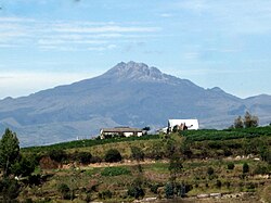
199:
175:
28:
118:
105:
144:
59:
143:, elevation 4,698 metres (15,413 ft), on the border of Ecuador and
232:
http://www.enciclopediadelecuador.com/geografia-del-ecuador/rio-carchi/
152:
136:
54:
85:
77:
68:
47:
42:
21:
196:Rand McNally, The New International Atlas, 1993.
8:
256:Austin: University of Texas Press, p. 74
254:Costume and History in Highland Ecuador,
33:The Carchi River rises on the slopes of
223:
18:
297:International rivers of South America
212:Water Resources Assessment of Ecuador
7:
14:
27:
1:
91:4,698 m (15,413 ft)
69:Physical characteristics
287:Geography of Carchi Province
163:which is a tributary of the
139:. It rises on the slopes of
87: • elevation
323:
16:River in Ecuador, Colombia
252:Meisch, Lynn. A. (2012),
192:List of rivers of Ecuador
95:
73:
26:
292:Colombia–Ecuador border
234:, accessed 18 Jun 2017
200:GEOnet Names Server
115: /
302:Rivers of Colombia
205:2020-04-10 at the
119:0.8153°N 77.6649°W
282:Rivers of Ecuador
153:Ipiales, Colombia
99:
98:
314:
266:
263:
257:
250:
244:
241:
235:
228:
157:Rumichaca Bridge
155:and beneath the
130:
129:
127:
126:
125:
124:0.8153; -77.6649
120:
116:
113:
112:
111:
108:
88:
31:
19:
322:
321:
317:
316:
315:
313:
312:
311:
272:
271:
270:
269:
264:
260:
251:
247:
242:
238:
229:
225:
220:
207:Wayback Machine
188:
149:Tulcan, Ecuador
123:
121:
117:
114:
109:
106:
104:
102:
101:
86:
64:
38:
17:
12:
11:
5:
320:
318:
310:
309:
304:
299:
294:
289:
284:
274:
273:
268:
267:
258:
245:
236:
230:"Rio Carchi",
222:
221:
219:
216:
215:
214:
209:
197:
194:
187:
184:
161:Guáitara River
141:Chiles Volcano
135:is a river of
97:
96:
93:
92:
89:
83:
82:
79:
75:
74:
71:
70:
66:
65:
63:
62:
57:
51:
49:
45:
44:
40:
39:
35:Chiles Volcano
32:
24:
23:
15:
13:
10:
9:
6:
4:
3:
2:
319:
308:
307:Border rivers
305:
303:
300:
298:
295:
293:
290:
288:
285:
283:
280:
279:
277:
262:
259:
255:
249:
246:
240:
237:
233:
227:
224:
217:
213:
210:
208:
204:
201:
198:
195:
193:
190:
189:
185:
183:
181:
177:
173:
168:
166:
162:
158:
154:
150:
146:
142:
138:
134:
128:
94:
90:
84:
80:
76:
72:
67:
61:
58:
56:
53:
52:
50:
46:
41:
36:
30:
25:
20:
261:
253:
248:
243:Google Earth
239:
226:
172:Pasto people
169:
133:Carchi River
132:
100:
22:Carchi River
176:Inca Empire
165:Patía River
122: /
276:Categories
218:References
110:77°39′54″W
107:0°48′55″N
48:Countries
203:Archived
186:See also
145:Colombia
60:Colombia
43:Location
180:Spanish
167:.
137:Ecuador
55:Ecuador
81:
78:Source
170:The
151:and
131:The
278::
37:.
Text is available under the Creative Commons Attribution-ShareAlike License. Additional terms may apply.