31:
223:
Cavitt Creek, a tributary of the Little River, enters the river upstream of the bridge. Cavitt Creek Road, after crossing Jim Creek, another Little River tributary, intersects Little River Road at the north end of the bridge. The bridge is a little more than a mile upstream of the small community of
437:
442:
51:
417:
447:
422:
412:
432:
362:
332:
205:
94:
36:
383:
427:
265:
252:
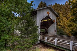
chords, three windows on each side, a metal roof, and long narrow slits above each truss for better lighting and ventilation.
30:
255:
The bridge was part of a thematic nomination of Oregon's covered bridges in 1979, but
Douglas County blocked the listing.
44:
294:
353:
193:
104:
245:
229:
358:
328:
209:
320:
189:
406:
233:
225:
213:
357:(7th ed.). Portland, Oregon: Oregon Historical Society Press. p. 181.
197:
137:
66:
53:
228:
and 7 miles (11 km) upstream of the Little River's confluence with the
204:. Built by Floyd C. Frear in 1943, it carries Cavitt Creek Road over the
327:(2nd ed.). Portland: Oregon Historical Society Press. p. 297.
217:
201:
249:
216:
and the road and bridge were named for Robert L. Cavitt, who
248:
portal arches allow room for log trucks, unhewn timbers for
396:
The map includes mile markers along the Little River.
174:
166:
156:
151:
143:
132:
127:
119:
111:
100:
90:
82:
43:
21:
351:McArthur, Lewis A.; McArthur, Lewis L. (2003) .
438:Tourist attractions in Douglas County, Oregon
8:
295:"Little River (Cavitt Creek) Covered Bridge"
378:
376:
374:
346:
344:
18:
220:along the creek in the mid-19th century.
443:Howe truss bridges in the United States
277:
289:
287:
285:
283:
281:
300:. Oregon Department of Transportation
7:
208:about 20 miles (32 km) east of
325:Historic Highway Bridges of Oregon
14:
418:Bridges in Douglas County, Oregon
386:. United States Geological Survey
29:
384:"United States Topographic Map"
16:Bridge in Oregon, United States
266:List of Oregon covered bridges
1:
448:1943 establishments in Oregon
323:; Dykman, Pieter T. (1989) .
35:Cavitt Creek Bridge over the
115:Little River Covered Bridge
464:
423:Covered bridges in Oregon
413:Bridges completed in 1943
179:
28:
433:Wooden bridges in Oregon
394:– via Acme Mapper.
67:43.244111°N 123.022000°W
354:Oregon Geographic Names
428:Road bridges in Oregon
105:Douglas County, Oregon
72:43.244111; -123.022000
186:Cavitt Creek Bridge
147:70 feet (21 m)
63: /
23:Cavitt Creek Bridge
319:Smith, Dwight A.;
230:North Umpqua River
183:
182:
86:Cavitt Creek Road
455:
397:
395:
393:
391:
380:
369:
368:
348:
339:
338:
321:Norman, James B.
316:
310:
309:
307:
305:
299:
291:
240:Notable Features
159:
78:
77:
75:
74:
73:
68:
64:
61:
60:
59:
56:
33:
19:
463:
462:
458:
457:
456:
454:
453:
452:
403:
402:
401:
400:
389:
387:
382:
381:
372:
365:
350:
349:
342:
335:
318:
317:
313:
303:
301:
297:
293:
292:
279:
274:
262:
242:
157:
128:Characteristics
107:, United States
71:
69:
65:
62:
57:
54:
52:
50:
49:
39:
24:
17:
12:
11:
5:
461:
459:
451:
450:
445:
440:
435:
430:
425:
420:
415:
405:
404:
399:
398:
370:
363:
340:
333:
311:
276:
275:
273:
270:
269:
268:
261:
258:
257:
256:
253:
241:
238:
194:Douglas County
190:covered bridge
181:
180:
177:
176:
172:
171:
168:
164:
163:
162:Floyd C. Frear
160:
158:Constructed by
154:
153:
149:
148:
145:
141:
140:
134:
130:
129:
125:
124:
123:Douglas County
121:
117:
116:
113:
109:
108:
102:
98:
97:
92:
88:
87:
84:
80:
79:
47:
41:
40:
34:
26:
25:
22:
15:
13:
10:
9:
6:
4:
3:
2:
460:
449:
446:
444:
441:
439:
436:
434:
431:
429:
426:
424:
421:
419:
416:
414:
411:
410:
408:
385:
379:
377:
375:
371:
366:
364:0-87595-277-1
360:
356:
355:
347:
345:
341:
336:
334:0-87595-205-4
330:
326:
322:
315:
312:
296:
290:
288:
286:
284:
282:
278:
271:
267:
264:
263:
259:
254:
251:
247:
244:
243:
239:
237:
235:
231:
227:
221:
219:
215:
211:
207:
203:
199:
195:
191:
187:
178:
173:
169:
165:
161:
155:
150:
146:
142:
139:
135:
131:
126:
122:
120:Maintained by
118:
114:
112:Other name(s)
110:
106:
103:
99:
96:
93:
89:
85:
81:
76:
58:123°01′19.2″W
48:
46:
42:
38:
32:
27:
20:
388:. Retrieved
352:
324:
314:
302:. Retrieved
222:
214:Cavitt Creek
206:Little River
185:
184:
144:Total length
95:Little River
55:43°14′38.8″N
37:Little River
70: /
45:Coordinates
407:Categories
272:References
198:U.S. state
138:Howe truss
390:March 22,
304:March 22,
260:See also
210:Roseburg
175:Location
136:Covered
218:settled
196:in the
152:History
91:Crosses
83:Carries
361:
331:
202:Oregon
167:Opened
133:Design
101:Locale
298:(PDF)
250:truss
246:Tudor
234:Glide
232:near
188:is a
392:2016
359:ISBN
329:ISBN
306:2016
226:Peel
170:1943
200:of
192:in
409::
373:^
343:^
280:^
236:.
212:.
367:.
337:.
308:.
Text is available under the Creative Commons Attribution-ShareAlike License. Additional terms may apply.