143:
22:
449:
130:
150:
66:, is a useful starting point for translations, but translators must revise errors as necessary and confirm that the translation is accurate, rather than simply copy-pasting machine-translated text into the English Knowledge.
372:
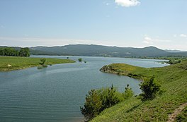
flows into and out of the lake. The dam is 55 metres (180 ft) high. The dam is also used to irrigate surrounding fields, which are largely used to grow potatoes. South of the lake are
52:
354:
valley. The dam was built in the Cecita valley near Cecita creek, a tributary of the Mucone. The creek is named after the valley, as are the dam and lake.
486:
189:
69:
Do not translate text that appears unreliable or low-quality. If possible, verify the text with references provided in the foreign-language article.
142:
510:
77:
425:
407:
479:
90:
Content in this edit is translated from the existing
Italian Knowledge article at ]; see its history for attribution.
505:
472:
350:, which flows from the slopes of mount Serra Stella, located between Monte Curcio and Monte Scuro, and into the
85:
361:, on behalf of energy producer S.M.E., Southern Electrical Society of Naples, and was completed in 1951.
106:
335:
327:
303:
171:
373:
365:
421:
403:
81:
334:
mountain range near the
Calabrian town of Camigliatello Silano. Its banks pass through towns
358:
323:
295:
99:
448:
226:
456:
311:
243:
233:
499:
221:
377:
34:
339:
357:
Dam construction began in 1947 by then local company
Lodigiani, now known as
204:
191:
307:
175:
129:
331:
88:
to the source of your translation. A model attribution edit summary is
369:
347:
343:
351:
420:(6 ed.). Hammond World Atlas Corporation. 2010. p. 54.
63:
322:
Lake Cecita is a man made reservoir created by constructing a
15:
402:(13 ed.). London: Times Books. 2011. p. 78 K5.
460:
59:
55:
a machine-translated version of the
Italian article.
281:
273:
265:
257:
253:
242:
232:
220:
181:
167:
122:
182:
84:accompanying your translation by providing an
46:Click for important translation instructions.
33:expand this article with text translated from
480:
364:The lake is located on the western border of
8:
487:
473:
400:The Times Comprehensive Atlas of the World
119:
389:
346:. The lake was created by damming the
455:This Calabrian location article is a
7:
445:
443:
238:154.5 km (59.7 sq mi)
149:
269:12.6 km (4.9 sq mi)
14:
277:108 hm (88,000 acre⋅ft)
447:
148:
141:
128:
20:
326:dam on the Mucone River in the
280:
272:
264:
256:
94:You may also add the template
1:
166:
96:{{Translated|it|Lago Cecita}}
459:. You can help Knowledge by
302:) is a man made lake in the
285:1,143 m (3,750 ft)
527:
442:
58:Machine translation, like
511:Calabrian geography stubs
261:7.5 km (4.7 mi)
136:
127:
35:the corresponding article
105:For more guidance, see
299:
107:Knowledge:Translation
78:copyright attribution
418:Hammond World Atlas
336:Spezzano della Sila
328:province of Cosenza
304:province of Cosenza
201: /
172:Province of Cosenza
374:Lago di Ariamacina
366:Sila National Park
86:interlanguage link
506:Lakes of Calabria
468:
467:
289:
288:
282:Surface elevation
118:
117:
47:
43:
518:
489:
482:
475:
451:
444:
434:
431:
413:
394:
359:Salini Impregilo
216:
215:
213:
212:
211:
206:
205:39.383°N 16.52°E
202:
199:
198:
197:
194:
184:
152:
151:
145:
132:
120:
97:
91:
64:Google Translate
45:
41:
24:
23:
16:
526:
525:
521:
520:
519:
517:
516:
515:
496:
495:
494:
493:
440:
438:
437:
428:
416:
410:
398:
395:
391:
386:
320:
246: countries
209:
207:
203:
200:
195:
192:
190:
188:
187:
163:
162:
161:
160:
159:
158:
157:
153:
114:
113:
112:
95:
89:
48:
25:
21:
12:
11:
5:
524:
522:
514:
513:
508:
498:
497:
492:
491:
484:
477:
469:
466:
465:
452:
436:
435:
433:
432:
426:
414:
408:
388:
387:
385:
382:
319:
316:
312:southern Italy
300:Lago di Cecita
287:
286:
283:
279:
278:
275:
271:
270:
267:
263:
262:
259:
255:
254:
251:
250:
247:
240:
239:
236:
234:Catchment area
230:
229:
224:
218:
217:
185:
179:
178:
169:
165:
164:
155:
154:
147:
146:
140:
139:
138:
137:
134:
133:
125:
124:
116:
115:
111:
110:
103:
92:
70:
67:
56:
49:
30:
29:
28:
26:
19:
13:
10:
9:
6:
4:
3:
2:
523:
512:
509:
507:
504:
503:
501:
490:
485:
483:
478:
476:
471:
470:
464:
462:
458:
453:
450:
446:
441:
429:
427:9780843715606
423:
419:
415:
411:
409:9780007419135
405:
401:
397:
396:
393:
390:
383:
381:
379:
375:
371:
367:
362:
360:
355:
353:
349:
345:
341:
337:
333:
329:
325:
324:hydroelectric
317:
315:
313:
309:
305:
301:
297:
293:
284:
276:
268:
260:
252:
248:
245:
241:
237:
235:
231:
228:
225:
223:
219:
214:
210:39.383; 16.52
186:
180:
177:
173:
170:
144:
135:
131:
126:
121:
108:
104:
101:
93:
87:
83:
79:
75:
71:
68:
65:
61:
57:
54:
51:
50:
44:
38:
36:
31:You can help
27:
18:
17:
461:expanding it
454:
439:
417:
399:
392:
378:Botte Donato
363:
356:
321:
291:
290:
274:Water volume
266:Surface area
82:edit summary
73:
40:
32:
292:Cecita Lake
258:Max. length
208: /
183:Coordinates
156:Cecita Lake
123:Cecita Lake
42:(July 2010)
500:Categories
384:References
340:Longobucco
227:Artificial
196:16°31′12″E
193:39°22′59″N
37:in Italian
318:Geography
100:talk page
330:, along
308:Calabria
176:Calabria
168:Location
76:provide
332:La Sila
296:Italian
98:to the
80:in the
39:.
424:
406:
370:Mucone
368:. The
348:Mucone
344:Celico
342:, and
352:Crati
249:Italy
244:Basin
60:DeepL
457:stub
422:ISBN
404:ISBN
376:and
222:Type
74:must
72:You
53:View
314:.
62:or
502::
380:.
338:,
310:,
306:,
298::
174:,
488:e
481:t
474:v
463:.
430:.
412:.
294:(
109:.
102:.
Text is available under the Creative Commons Attribution-ShareAlike License. Additional terms may apply.