128:
121:
307:
31:
176:
348:
372:
246:
Nuttall, John & Anne (1999). The
Mountains of England & Wales - Volume 1: Wales (2nd edition ed.). Milnthorpe, Cumbria: Cicerone.
120:
251:
382:
341:
223:
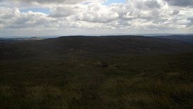
The views from the summit are extensive, if unremarkable due to the featureless, flat moorland surroundings. LLyn
Efyrnwy (
230:
Cefn
Gwyntog is renowned as one of the hardest summits in Wales to reach, due to its remoteness and hard walking terrain.
170:
268:
367:
334:
217:
227:) can be seen below. The summit is marked by a small cairn surrounded by peat bog and knee deep heather.
59:
69:
377:
247:
318:
306:
189:
184:
156:
102:
79:
361:
75:
213:
163:
224:
205:
283:
270:
36:
30:
314:
140:
49:
209:
144:
216:
known as the
Hirnantau. Its summit lies just outside the
322:
183:
169:
155:
108:
98:
90:
85:
68:
58:
48:
43:
23:
342:
8:
349:
335:
20:
239:
7:
303:
301:
127:
321:. You can help Knowledge (XXG) by
14:
305:
126:
119:
29:
373:Mountains and hills of Gwynedd
1:
16:Hill (614m) in Powys, Wales
399:
300:
54:615 m (2,018 ft)
212:. It forms a part of the
113:
28:
383:Gwynedd geography stubs
218:Snowdonia National Park
317:location article is a
64:27 m (89 ft)
284:52.82722°N 3.52111°W
280: /
91:English translation
289:52.82722; -3.52111
44:Highest point
35:Cefn Gwyntog from
330:
329:
199:
198:
390:
368:Hewitts of Wales
351:
344:
337:
309:
302:
295:
294:
292:
291:
290:
285:
281:
278:
277:
276:
273:
255:
244:
179:
159:
130:
129:
123:
99:Language of name
33:
21:
398:
397:
393:
392:
391:
389:
388:
387:
358:
357:
356:
355:
298:
288:
286:
282:
279:
274:
271:
269:
267:
266:
264:
259:
258:
245:
241:
236:
175:
157:
151:
150:
149:
148:
147:
138:
137:
136:
135:
131:
39:
17:
12:
11:
5:
396:
394:
386:
385:
380:
375:
370:
360:
359:
354:
353:
346:
339:
331:
328:
327:
310:
263:
262:External links
260:
257:
256:
238:
237:
235:
232:
208:in north east
197:
196:
187:
181:
180:
177:SH 97603 26596
173:
167:
166:
161:
153:
152:
139:
133:
132:
125:
124:
118:
117:
116:
115:
114:
111:
110:
106:
105:
100:
96:
95:
92:
88:
87:
83:
82:
72:
66:
65:
62:
56:
55:
52:
46:
45:
41:
40:
34:
26:
25:
15:
13:
10:
9:
6:
4:
3:
2:
395:
384:
381:
379:
376:
374:
371:
369:
366:
365:
363:
352:
347:
345:
340:
338:
333:
332:
326:
324:
320:
316:
311:
308:
304:
299:
296:
293:
261:
253:
252:1-85284-304-7
249:
243:
240:
233:
231:
228:
226:
221:
219:
215:
211:
207:
203:
194:
191:
188:
186:
182:
178:
174:
172:
168:
165:
162:
160:
154:
146:
142:
122:
112:
107:
104:
101:
97:
93:
89:
84:
81:
77:
73:
71:
67:
63:
61:
57:
53:
51:
47:
42:
38:
32:
27:
22:
19:
323:expanding it
312:
297:
265:
242:
229:
222:
214:Berwyn range
204:is a top of
202:Cefn Gwyntog
201:
200:
192:
164:Berwyn range
158:Parent range
134:Cefn Gwyntog
24:Cefn Gwyntog
18:
287: /
225:Lake Vyrnwy
206:Cyrniau Nod
94:windy ridge
362:Categories
272:52°49′38″N
234:References
193:Landranger
60:Prominence
275:3°31′16″W
109:Geography
50:Elevation
37:Stac Rhos
378:Nuttalls
185:Topo map
315:Gwynedd
171:OS grid
141:Gwynedd
80:Nuttall
70:Listing
250:
86:Naming
76:Hewitt
313:This
210:Wales
145:Wales
103:Welsh
319:stub
248:ISBN
74:sub
195:125
364::
220:.
190:OS
143:,
78:,
350:e
343:t
336:v
325:.
254:.
Text is available under the Creative Commons Attribution-ShareAlike License. Additional terms may apply.