75:
139:
48:
172:
493:
climatic conditions in
Central Maluku Regency in general: The average temperature recorded in 2009 in Amahai District was 26.30C, where the maximum average temperature was 30.40C and the minimum average was 23.30C. The average amount of rainfall in 2009 was 185.1 mm with an average number of rainy days of 18.1 days. The average sun irradiation in 2009 was 65.9% with an average air pressure of 1,011.2 millibars and an average relative humidity of 84.9%.
1533:
95:
179:
146:
102:
492:
The
Central Maluku region experiences a tropical marine climate and a monsoon climate. This is because Central Maluku is surrounded by vast seas, so that the tropical marine climate in this area is in rhythm with the existing seasonal climate. The following climatological conditions can describe the
509:), tabulated below with their areas (in km) and their populations at the 2010 Census and the 2020 Census, together with the official estimates as at mid 2023. The table also includes the locations of the district administrative centres, the number of
397:. The Regency covers an area of 11,595.57 km, and had a population of 361,698 at the 2010 Census, and 423,094 at the 2020 Census. The official estimate as at mid 2023 was 430,798. The principal town lies at
1350:(g) 2010 population figures for Seram Utara Timur Kobi and Seram Utara Timur Seti are included in that for Seram Utara. (h) 2010 population figure for Telutih is included in that for Tehoru.
1348:(f) includes Pulau Besar (on which the admin centre Pasanea is located) and smaller islands (a total of 4.6 km with 1,040 inhabitants in mid 2022) off the north coast of Seram.
207:
484:
much further to the south. The total area of
Central Maluku Regency is approx 275,907 km, which consists of a sea area of 264,311.43 km and a land area of 11,595.57 km.
472:
in the east, both of which were separated from
Central Maluku Regency on 18 December 2003), but it also includes a number of islands to the south, chiefly
74:
35:
138:
47:
1324:(a) including the small offshore islands of Ela, Hatala and Lain. (b) 2010 population figure for Saparua Timur is included in that for Saparua.
171:
1346:(with mid 2022 populations) are Wahai, the admin centre (5,988), Sawai (3,792), Manusela (2,196), Pasahari (1,586) and Malaku (1,426).
1446:
1575:
94:
347:
1340:(with 2020 Census populations) of Ampera (6,385), Lesane (4,493), Letwaru (6,412), Namaelo (15,280) and Namasina (3,863).
1334:
including Haruru (9,456), Sepa (8,544), Tamilouw (7,917), Soahuku (4,791), Makariki (4,128) and Amahai (3,664).
1541:
1517:
1512:
1507:
239:
1532:
510:
502:
453:
386:
251:
1439:
1482:
1474:
378:
263:
1522:
1502:
1497:
469:
465:
476:(site of the provincial capital of the same name, but excluding the City of Ambon itself), the
1456:
390:
339:
256:
80:
1432:
457:
119:
1569:
1549:
1466:
1289:
736:
481:
477:
438:
426:
418:
1487:
473:
461:
434:
414:
410:
402:
1424:
222:
209:
430:
394:
330:
244:
123:
1359:
770:
422:
1119:
945:
398:
335:
268:
115:
1554:
1428:
444:
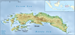
This regency is the largest in area among
Malukan regencies.
1409:
1407:
1405:
1379:
1377:
1375:
1395:
1393:
361:
1330:
of Hollo (with 1,745 inhabitants in mid 2022) and 14
1540:
1473:
409:) is composed of the central part of the island of
356:
346:
329:
321:
313:
308:
300:
295:
287:
279:
274:
262:
250:
238:
21:
1383:Badan Pusat Statistik, Jakarta, 28 February 2024,
460:. It is mainly located in the central part of
178:
145:
101:
1440:
8:
304:11,595.57 km (4,477.07 sq mi)
1447:
1433:
1425:
523:
18:
1385:Kabupaten Maluku Tengah Dalam Angka 2024
1371:
513:in each district (a total of 186 rural
355:
345:
328:
307:
294:
273:
261:
237:
202:
86:
71:
59:
41:
67:(Building the Homeland and the Nation)
1413:Badan Pusat Statistik, Jakarta, 2021.
501:The regency is divided into eighteen
452:Central Maluku Regency is one of the
320:
312:
299:
286:
278:
249:
7:
1399:Biro Pusat Statistik, Jakarta, 2011.
191:Central Maluku Regency (Indonesia)
14:
1531:
433:), together with those parts of
177:
170:
144:
137:
100:
93:
73:
46:
158:Central Maluku Regency (Maluku)
480:to the east of Ambon, and the
437:which are outside the City of
1:
1311:
1276:
1233:
1202:
1172:
1140:
1107:
1072:
1037:
1001:
967:
933:
901:
856:
822:
791:
758:
723:
680:
649:
617:
16:Regency in Maluku, Indonesia
1308:
1305:
1302:
1299:
1271:
1266:
1261:
1256:
1230:
1227:
1224:
1221:
1199:
1196:
1194:
1191:
1169:
1166:
1163:
1160:
1137:
1134:
1131:
1128:
1104:
1101:
1099:
1096:
1069:
1066:
1064:
1061:
1034:
1031:
1028:
1025:
998:
995:
992:
989:
964:
961:
958:
955:
930:
927:
924:
921:
896:
891:
886:
881:
853:
850:
847:
844:
819:
816:
814:
811:
788:
785:
782:
779:
755:
752:
749:
746:
718:
713:
708:
703:
677:
674:
671:
668:
646:
643:
640:
637:
614:
611:
608:
605:
1592:
1387:(Katalog-BPS 1102001.8101)
1529:
1463:
203:
87:
72:
60:
42:
33:
1455:Regencies and cities of
288: • Vice Regent
128:Show map of Seram Island
25:
1336:(d) comprises the five
511:administrative villages
383:Kabupaten Maluku Tengah
27:Kabupaten Maluku Tengah
1576:Central Maluku Regency
1247:totals on Seram Island
694:totals on Ambon Island
521:), and its post code.
382:
375:Central Maluku Regency
185:Central Maluku Regency
152:Central Maluku Regency
108:Central Maluku Regency
23:Central Maluku Regency
325:37/km (96/sq mi)
223:3.29167°S 128.96750°E
194:Show map of Indonesia
322: • Density
280: • Regent
228:-3.29167; 128.96750
219: /
1326:(c) comprises the
470:East Seram Regency
466:West Seram Regency
314: • Total
301: • Total
291:Marlatu L. Leleury
161:Show map of Maluku
1563:
1562:
1319:
1318:
372:
371:
1583:
1535:
1518:Tanimbar Islands
1513:Southwest Maluku
1508:Southeast Maluku
1449:
1442:
1435:
1426:
1414:
1411:
1400:
1397:
1388:
1381:
524:
468:in the west and
405:. The regency (
368:
365:
363:
234:
233:
231:
230:
229:
224:
220:
217:
216:
215:
212:
195:
181:
180:
174:
162:
148:
147:
141:
129:
104:
103:
97:
79:Location within
77:
50:
19:
1591:
1590:
1586:
1585:
1584:
1582:
1581:
1580:
1566:
1565:
1564:
1559:
1536:
1527:
1469:
1459:
1453:
1423:
1418:
1417:
1412:
1403:
1398:
1391:
1382:
1373:
1368:
1356:
1349:
1347:
1341:
1335:
1325:
1214:Teon Nila Serua
1152:Teluk Elpaputih
1090:
1085:
1055:
1050:
1019:
1014:
972:
871:
838:
589:
584:
582:
577:
575:
570:
568:
563:
561:
556:
554:
549:
544:
535:
533:
528:
499:
490:
458:Maluku Province
450:
360:
227:
225:
221:
218:
213:
210:
208:
206:
205:
199:
198:
197:
196:
193:
192:
189:
188:
187:
186:
182:
165:
164:
163:
160:
159:
156:
155:
154:
153:
149:
132:
131:
130:
127:
126:
112:
111:
110:
109:
105:
83:
68:
66:
61:Motto(s):
56:
55:
54:
53:
38:
29:
24:
17:
12:
11:
5:
1589:
1587:
1579:
1578:
1568:
1567:
1561:
1560:
1558:
1557:
1552:
1546:
1544:
1538:
1537:
1530:
1528:
1526:
1525:
1520:
1515:
1510:
1505:
1500:
1495:
1493:Central Maluku
1490:
1485:
1479:
1477:
1471:
1470:
1464:
1461:
1460:
1454:
1452:
1451:
1444:
1437:
1429:
1422:
1421:External links
1419:
1416:
1415:
1401:
1389:
1370:
1369:
1367:
1364:
1363:
1362:
1355:
1352:
1342:(e) the major
1317:
1316:
1313:
1310:
1307:
1304:
1301:
1298:
1295:
1292:
1287:
1283:
1282:
1280:
1275:
1270:
1265:
1260:
1255:
1253:
1251:
1242:
1239:
1238:
1235:
1232:
1229:
1226:
1223:
1220:
1217:
1215:
1212:
1208:
1207:
1204:
1201:
1198:
1195:
1193:
1190:
1187:
1185:
1182:
1178:
1177:
1174:
1171:
1168:
1165:
1162:
1159:
1156:
1153:
1150:
1146:
1145:
1142:
1139:
1136:
1133:
1130:
1127:
1124:
1122:
1117:
1113:
1112:
1109:
1106:
1103:
1100:
1098:
1095:
1092:
1087:
1082:
1078:
1077:
1074:
1071:
1068:
1065:
1063:
1060:
1057:
1052:
1047:
1043:
1042:
1039:
1036:
1033:
1030:
1027:
1024:
1021:
1016:
1011:
1007:
1006:
1003:
1000:
997:
994:
991:
988:
985:
982:
979:
975:
974:
969:
966:
963:
960:
957:
954:
951:
948:
943:
939:
938:
935:
932:
929:
926:
923:
920:
917:
915:
912:
908:
907:
905:
900:
895:
890:
885:
880:
878:
876:
865:
862:
861:
858:
855:
852:
849:
846:
843:
840:
835:
832:
828:
827:
824:
821:
818:
815:
813:
810:
807:
804:
801:
797:
796:
793:
790:
787:
784:
781:
778:
775:
773:
768:
764:
763:
760:
757:
754:
751:
748:
745:
742:
739:
734:
730:
729:
727:
722:
717:
712:
707:
702:
700:
698:
689:
686:
685:
682:
679:
676:
673:
670:
667:
664:
662:
659:
655:
654:
651:
648:
645:
642:
639:
636:
633:
630:
627:
623:
622:
619:
616:
613:
610:
607:
604:
601:
599:
596:
592:
591:
586:
579:
572:
565:
558:
551:
546:
541:
530:
498:
497:Administration
495:
489:
486:
449:
446:
370:
369:
358:
354:
353:
350:
344:
343:
333:
327:
326:
323:
319:
318:
315:
311:
310:
306:
305:
302:
298:
297:
293:
292:
289:
285:
284:
281:
277:
276:
272:
271:
266:
260:
259:
254:
248:
247:
242:
236:
235:
201:
200:
190:
184:
183:
176:
175:
169:
168:
167:
166:
157:
151:
150:
143:
142:
136:
135:
134:
133:
113:
107:
106:
99:
98:
92:
91:
90:
89:
88:
85:
84:
78:
70:
69:
62:
58:
57:
51:
45:
44:
43:
40:
39:
34:
31:
30:
22:
15:
13:
10:
9:
6:
4:
3:
2:
1588:
1577:
1574:
1573:
1571:
1556:
1553:
1551:
1548:
1547:
1545:
1543:
1539:
1534:
1524:
1521:
1519:
1516:
1514:
1511:
1509:
1506:
1504:
1501:
1499:
1496:
1494:
1491:
1489:
1486:
1484:
1481:
1480:
1478:
1476:
1472:
1468:
1462:
1458:
1450:
1445:
1443:
1438:
1436:
1431:
1430:
1427:
1420:
1410:
1408:
1406:
1402:
1396:
1394:
1390:
1386:
1380:
1378:
1376:
1372:
1365:
1361:
1358:
1357:
1353:
1351:
1345:
1339:
1333:
1329:
1323:
1314:
1296:
1294:Banda Islands
1293:
1291:
1288:
1285:
1284:
1281:
1279:
1274:
1269:
1264:
1259:
1254:
1252:
1250:
1248:
1243:
1241:
1240:
1236:
1218:
1216:
1213:
1210:
1209:
1205:
1188:
1186:
1183:
1180:
1179:
1175:
1157:
1155:Elpaputih Bay
1154:
1151:
1148:
1147:
1143:
1125:
1123:
1121:
1118:
1115:
1114:
1110:
1093:
1088:
1083:
1080:
1079:
1075:
1058:
1053:
1048:
1045:
1044:
1040:
1022:
1017:
1012:
1009:
1008:
1004:
986:
983:
980:
977:
976:
970:
952:
949:
947:
944:
941:
940:
936:
918:
916:
913:
910:
909:
906:
904:
899:
894:
889:
884:
879:
877:
875:
873:
872:Lease Islands
866:
864:
863:
859:
841:
836:
833:
830:
829:
825:
808:
805:
803:Saparua Timur
802:
799:
798:
794:
776:
774:
772:
769:
766:
765:
761:
743:
741:Haruku Island
740:
738:
735:
732:
731:
728:
726:
721:
716:
711:
706:
701:
699:
697:
695:
690:
688:
687:
683:
665:
663:
660:
657:
656:
652:
634:
631:
629:Leihitu Barat
628:
625:
624:
620:
602:
600:
597:
594:
593:
587:
580:
573:
566:
559:
552:
547:
542:
539:
531:
526:
525:
522:
520:
516:
512:
508:
504:
496:
494:
487:
485:
483:
482:Banda Islands
479:
478:Lease Islands
475:
471:
467:
463:
459:
455:
447:
445:
442:
440:
436:
432:
428:
424:
420:
419:Lease Islands
416:
415:Banda Islands
412:
408:
404:
400:
396:
392:
388:
384:
380:
376:
367:
359:
351:
349:
341:
337:
334:
332:
324:
316:
303:
290:
283:Tuasikal Abua
282:
270:
267:
265:
258:
255:
253:
246:
243:
241:
232:
204:Coordinates:
173:
140:
125:
121:
117:
96:
82:
76:
65:
49:
37:
32:
28:
20:
1492:
1384:
1343:
1337:
1331:
1327:
1321:
1320:
1277:
1272:
1267:
1262:
1257:
1246:
1244:
902:
897:
892:
887:
882:
869:
867:
806:East Saparua
777:Kota Saparua
737:Pulau Haruku
724:
719:
714:
709:
704:
693:
691:
632:West Leihitu
537:
518:
517:and 6 urban
514:
506:
500:
491:
474:Ambon Island
462:Seram Island
451:
443:
435:Ambon Island
406:
403:Seram Island
393:Province of
374:
373:
114:Location in
64:Pamahanunusa
63:
52:Coat of arms
26:
1483:Aru Islands
1084:Seram Utara
1049:Seram Utara
1013:Seram Utara
984:North Seram
981:Seram Utara
950:Masohi Town
946:Kota Masohi
226: /
214:128°58′03″E
1523:West Seram
1503:South Buru
1498:East Seram
1366:References
1091:Seram Seti
1086:Timur Seti
1056:Seram Kobi
1051:Timur Kobi
417:, and the
379:Indonesian
362:maltengkab
309:Population
275:Government
1475:Regencies
1465:Capital:
1338:kelurahan
1328:kelurahan
1297:Nusantara
1258:10,680.65
1094:Kobisonta
1089:Northeast
1054:Northeast
1018:Northwest
870:totals on
837:Nusa Laut
834:Nusa Laut
538:kecamatan
519:kelurahan
507:kecamatan
503:districts
464:(between
454:regencies
448:Geography
431:Nusa Laut
407:kebupaten
395:Indonesia
352:(+62) 914
348:Area code
331:Time zone
245:Indonesia
211:3°17′30″S
124:Indonesia
1570:Category
1354:Villages
1286:81.01.09
1211:81.01.02
1181:81.01.23
1149:81.01.21
1116:81.01.11
1081:81.01.24
1046:81.01.25
1010:81.01.20
990:7,173.46
978:81.01.06
942:81.01.17
922:1,619.07
911:81.01.01
831:81.01.16
800:81.01.26
767:81.01.12
733:81.01.13
661:Salahutu
658:81.01.14
626:81.01.22
598:Leihitu
595:81.01.15
585:villages
578:mid 2023
576:Estimate
534:District
252:Province
1360:Yaputih
1273:213,694
1268:204,907
1263:170,791
1184:Telutih
1158:Sahulau
1023:Pasanea
973:-97515
771:Saparua
720:128,754
715:128,069
710:110,359
543:English
532:Name of
529:Wilayah
488:Climate
423:Saparua
387:regency
385:) is a
357:Website
317:430,798
264:Capital
240:Country
36:Regency
1542:Cities
1457:Maluku
1322:Notes:
1315:97586
1309:21,902
1306:20,924
1303:18,544
1300:172.00
1237:97535
1231:14,422
1228:14,594
1225:12,857
1219:Waipia
1206:97510
1200:13,630
1197:12,838
1192:128.50
1176:97517
1170:10,069
1164:10,822
1161:120.00
1144:97519
1138:24,276
1135:22,486
1132:28,191
1129:405.72
1126:Tehoru
1120:Tehoru
1111:97534
1105:16,279
1102:14,975
1097:186.19
1076:97533
1070:13,558
1067:12,682
1062:280.65
1041:97532
1035:12,752
1032:12,024
1026:705.48
1015:Barat
1005:97531
999:21,697
996:19,681
993:39,249
965:36,533
962:36,433
959:31,480
953:Masohi
937:97516
931:50,478
928:50,028
925:38,932
919:Amahai
914:Amahai
898:66,448
893:69,192
888:62,004
883:359.00
860:97518
839:Island
826:97585
820:16,912
817:17,620
809:Tuhaha
795:97584
789:17,548
786:18,402
783:32,475
762:97583
756:26,551
753:27,390
750:24,207
747:150.00
744:Pelauw
705:383.92
684:97582
678:54,166
675:54,798
672:46,703
669:151.82
666:Tulehu
653:97581
647:19,724
644:19,543
641:16,678
635:Larike
621:97580
615:54,864
612:53,728
609:46,978
606:147.63
569:Census
562:Census
550:Centre
429:, and
427:Haruku
413:, the
399:Masohi
391:Maluku
269:Masohi
257:Maluku
120:Maluku
81:Maluku
1550:Ambon
1467:Ambon
1290:Banda
1222:24.28
1189:Laimu
1167:9,166
1029:9,260
1020:Seram
987:Wahai
971:97511
956:37.30
854:5,437
851:5,780
848:5,322
845:32.50
842:Ameth
812:96.60
780:79.90
638:84.47
590:code
574:Pop'n
567:Pop'n
560:Pop'n
548:Admin
527:Kode
439:Ambon
411:Seram
401:, on
336:UTC+9
116:Seram
1555:Tual
1488:Buru
1344:desa
1332:desa
1059:Kobi
603:Hila
588:Post
571:2020
564:2010
553:Area
545:name
515:desa
340:IEST
296:Area
122:and
1278:117
581:No.
555:in
456:in
389:of
366:.id
364:.go
1572::
1404:^
1392:^
1374:^
1312:18
1234:16
1203:10
1141:10
1108:12
1073:12
1038:13
1002:20
934:15
903:35
823:10
759:11
725:22
618:11
583:of
557:km
441:.
425:,
381::
118:,
1448:e
1441:t
1434:v
1249:)
1245:(
1173:4
968:5
874:)
868:(
857:7
792:7
696:)
692:(
681:6
650:5
540:)
536:(
505:(
421:(
377:(
342:)
338:(
Text is available under the Creative Commons Attribution-ShareAlike License. Additional terms may apply.