48:
29:
55:
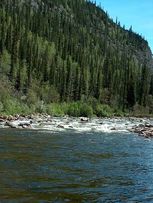
385:, rising to Class IV (advanced) in high water. The lower 76 miles (122 km) are rated Class II (novice) to III. Dangers include swift current, overhanging or submerged vegetation, rocks, rapids, and weather-related fluctuations in water levels.
1482:
1487:
1492:
622:
1325:
1097:
695:
751:
1502:
665:
944:
1102:
1152:
1062:
713:
800:
330:
34:
823:
818:
757:
592:
1497:
643:
615:
382:
366:
95:
1455:
1197:
1012:
670:
341:
276:
370:
99:
1067:
690:
565:
497:
1295:
1225:
893:
888:
790:
631:
1187:
1230:
762:
608:
381:
The
Charley River is generally floated by raft or inflatable canoe or kayak. The upper river is rated Class III (intermediate) on the
47:
1343:
1037:
992:
833:
733:
675:
660:
1182:
1142:
1057:
1027:
873:
868:
863:
843:
221:
903:
883:
878:
858:
848:
838:
828:
1077:
1042:
1007:
853:
767:
723:
1419:
926:
771:
745:
142:
1072:
1002:
952:
1366:
1335:
1147:
1047:
987:
685:
680:
1477:
1374:
1082:
997:
1437:
359:. This general locus within the Yukon River catchment is the approximate westernmost limit of the black spruce,
1404:
1275:
1132:
1112:
1087:
810:
795:
705:
394:
1399:
425:
1432:
1409:
1394:
1137:
1017:
916:
911:
326:
1177:
1052:
1032:
982:
1427:
967:
957:
652:
118:
1357:
1265:
1240:
1127:
977:
972:
962:
1384:
1379:
1167:
1117:
1092:
934:
1389:
1157:
1122:
1022:
782:
561:
493:
333:. The Charley River enters the larger river downstream and 55 miles (89 km) northwest of
1320:
1215:
741:
1315:
1280:
1250:
1220:
348:
as well as Copper, Bonanza, Hosford, Derwent, Flat-Orthmer, Crescent, and
Moraine creeks.
1310:
1305:
717:
1471:
1300:
1290:
1260:
1255:
1205:
1172:
1107:
361:
334:
206:
1285:
1210:
451:
356:
352:
1270:
1245:
314:
193:
188:
325:. Flowing generally northeast from the Mertie Mountains (named after geologist
340:
In 1980, the
Charley River and all of its main tributaries became part of the
318:
236:
223:
157:
144:
130:
Yukon–Charley Rivers
National Preserve, Southeast Fairbanks Census Area
1162:
600:
558:
The Alaska River Guide: Canoeing, Kayaking, and
Rafting in the Last Frontier
516:
345:
28:
560:(3rd ed.). Birmingham, Alabama: Menasha Ridge Press. pp. 100–02.
344:. A total of 208 miles (335 km) was declared "wild" along the entire
329:) in the northeastern part of the state, the river lies entirely within
635:
322:
492:(7th ed.). Yarmouth, Maine: DeLorme. 2010. pp. 118, 128.
604:
464:
351:
The
Charley River watershed is forested chiefly with
62:
Location of the mouth of the
Charley River in Alaska
1418:
1365:
1356:
1334:
1196:
943:
925:
902:
809:
781:
732:
704:
651:
642:
365:. The river forms part of the boundary between the
291:
283:
274:
262:
252:
213:
199:
187:
173:
134:
124:
114:
105:
91:
83:
75:
70:
21:
432:. United States Geological Survey. January 1, 2000
1483:Rivers of Southeast Fairbanks Census Area, Alaska
616:
511:
509:
313:is an 88-mile (142 km) tributary of the
8:
331:Yukon–Charley Rivers National Preserve
35:Yukon–Charley Rivers National Preserve
1493:Wild and Scenic Rivers of the United States
1488:Rivers of Yukon–Koyukuk Census Area, Alaska
596:, GlobalTwitcher.com, ed. Nicklas Stromberg
1362:
648:
623:
609:
601:
450:Derived by entering source coordinates in
471:. National Wild and Scenic Rivers System
465:"National Wild and Scenic Rivers System"
406:
383:International Scale of River Difficulty
1456:Alaska Department of Natural Resources
420:
418:
416:
414:
412:
410:
342:National Wild and Scenic Rivers System
18:
1503:Rivers of Unorganized Borough, Alaska
290:
282:
273:
54:
7:
588:, Alaska Department of Fish and Game
586:Geological Map of the Charley Basin
430:Geographic Names Information System
205:55 miles (89 km) northwest of
1098:Petersburg Creek–Duncan Salt Chuck
14:
1103:Pleasant/Lemesurier/Inian Islands
519:. National Wild and Scenic Rivers
209:, Yukon–Koyukuk Census Area
287:Wild 208.0 miles (334.7 km)
53:
46:
27:
1498:Tributaries of the Yukon River
277:National Wild and Scenic River
215: • coordinates
136: • coordinates
16:River in Alaska, United States
1:
752:Aleutian Islands World War II
106:Physical characteristics
490:Alaska Atlas & Gazetteer
254: • elevation
179:4,023 ft (1,226 m)
175: • elevation
594:Black Spruce: Picea mariana
201: • location
126: • location
1519:
1336:National Conservation Area
1450:
811:National Wildlife Refuges
706:National Historical Parks
584:J.G. Clough et al. 1995.
303:
299:
270:
183:
110:
41:
26:
591:C. Michael Hogan. 2008.
556:Jettmar, Karen (2008) .
395:List of rivers of Alaska
266:88 mi (142 km)
258:686 ft (209 m)
537:J.G. Clough et al. 1995
517:"Charley River, Alaska"
327:John Beaver Mertie, Jr.
1198:Wild and Scenic Rivers
1163:Tracy Arm-Fords Terror
546:C. Michael Hogan. 2008
237:65.31722°N 142.78056°W
158:64.70417°N 144.04472°W
1183:West Chichagof-Yakobi
1143:South Prince of Wales
1188:Wrangell–Saint Elias
927:Forest Service units
801:Yukon–Charley Rivers
242:65.31722; -142.78056
163:64.70417; -144.04472
1008:Gates of the Arctic
666:Gates of the Arctic
371:Yukon–Koyukuk
367:Southeast Fairbanks
233: /
154: /
100:Yukon–Koyukuk
96:Southeast Fairbanks
1276:North Fork Koyukuk
935:Mendenhall Glacier
791:Bering Land Bridge
783:National Preserves
734:National Monuments
714:Klondike Gold Rush
696:Wrangell–St. Elias
1465:
1464:
1446:
1445:
1352:
1351:
988:Coronation Island
567:978-0-89732-957-6
499:978-0-89933-289-5
307:
306:
1510:
1478:Rivers of Alaska
1363:
1073:Maurille Islands
1003:Forrester Island
953:Aleutian Islands
945:Wilderness Areas
904:National Forests
824:Alaska Peninsula
763:Cape Krusenstern
742:Admiralty Island
649:
625:
618:
611:
602:
572:
571:
553:
547:
544:
538:
535:
529:
528:
526:
524:
513:
504:
503:
486:
480:
479:
477:
476:
461:
455:
448:
442:
441:
439:
437:
422:
295:December 2, 1980
248:
247:
245:
244:
243:
238:
234:
231:
230:
229:
226:
176:
169:
168:
166:
165:
164:
159:
155:
152:
151:
150:
147:
137:
127:
119:Mertie Mountains
57:
56:
50:
33:Flowing through
31:
19:
1518:
1517:
1513:
1512:
1511:
1509:
1508:
1507:
1468:
1467:
1466:
1461:
1442:
1414:
1348:
1330:
1192:
1148:Stikine-LeConte
939:
921:
898:
819:Alaska Maritime
805:
777:
728:
700:
638:
632:Protected areas
629:
581:
576:
575:
568:
555:
554:
550:
545:
541:
536:
532:
522:
520:
515:
514:
507:
500:
488:
487:
483:
474:
472:
463:
462:
458:
449:
445:
435:
433:
426:"Charley River"
424:
423:
408:
403:
391:
379:
279:
255:
241:
239:
235:
232:
227:
224:
222:
220:
219:
216:
202:
174:
162:
160:
156:
153:
148:
145:
143:
141:
140:
135:
125:
66:
65:
64:
63:
60:
59:
58:
37:
17:
12:
11:
5:
1516:
1514:
1506:
1505:
1500:
1495:
1490:
1485:
1480:
1470:
1469:
1463:
1462:
1460:
1459:
1451:
1448:
1447:
1444:
1443:
1441:
1440:
1435:
1430:
1424:
1422:
1416:
1415:
1413:
1412:
1407:
1402:
1397:
1392:
1387:
1382:
1377:
1375:Afognak Island
1371:
1369:
1360:
1354:
1353:
1350:
1349:
1347:
1346:
1340:
1338:
1332:
1331:
1329:
1328:
1323:
1318:
1313:
1308:
1303:
1298:
1293:
1288:
1283:
1278:
1273:
1268:
1263:
1258:
1253:
1248:
1243:
1238:
1233:
1228:
1223:
1218:
1213:
1208:
1202:
1200:
1194:
1193:
1191:
1190:
1185:
1180:
1175:
1170:
1165:
1160:
1155:
1150:
1145:
1140:
1135:
1130:
1125:
1120:
1115:
1110:
1105:
1100:
1095:
1090:
1085:
1083:Mollie Beattie
1080:
1075:
1070:
1065:
1060:
1055:
1050:
1045:
1040:
1035:
1030:
1025:
1020:
1015:
1010:
1005:
1000:
998:Endicott River
995:
990:
985:
980:
975:
970:
965:
960:
955:
949:
947:
941:
940:
938:
937:
931:
929:
923:
922:
920:
919:
914:
908:
906:
900:
899:
897:
896:
891:
886:
881:
876:
871:
866:
861:
856:
851:
846:
841:
836:
831:
826:
821:
815:
813:
807:
806:
804:
803:
798:
793:
787:
785:
779:
778:
776:
775:
765:
760:
755:
749:
738:
736:
730:
729:
727:
726:
721:
718:Chilkoot Trail
710:
708:
702:
701:
699:
698:
693:
688:
683:
678:
673:
668:
663:
657:
655:
653:National Parks
646:
640:
639:
630:
628:
627:
620:
613:
605:
599:
598:
589:
580:
577:
574:
573:
566:
548:
539:
530:
505:
498:
481:
456:
443:
405:
404:
402:
399:
398:
397:
390:
387:
378:
375:
373:census areas.
305:
304:
301:
300:
297:
296:
293:
289:
288:
285:
281:
280:
275:
272:
271:
268:
267:
264:
260:
259:
256:
253:
250:
249:
217:
214:
211:
210:
203:
200:
197:
196:
191:
185:
184:
181:
180:
177:
171:
170:
138:
132:
131:
128:
122:
121:
116:
112:
111:
108:
107:
103:
102:
93:
89:
88:
85:
81:
80:
77:
73:
72:
68:
67:
61:
52:
51:
45:
44:
43:
42:
39:
38:
32:
24:
23:
15:
13:
10:
9:
6:
4:
3:
2:
1515:
1504:
1501:
1499:
1496:
1494:
1491:
1489:
1486:
1484:
1481:
1479:
1476:
1475:
1473:
1458:
1457:
1453:
1452:
1449:
1439:
1438:Tanana Valley
1436:
1434:
1431:
1429:
1426:
1425:
1423:
1421:
1420:State Forests
1417:
1411:
1408:
1406:
1405:Shuyak Island
1403:
1401:
1400:Point Bridget
1398:
1396:
1393:
1391:
1388:
1386:
1383:
1381:
1378:
1376:
1373:
1372:
1370:
1368:
1364:
1361:
1359:
1355:
1345:
1342:
1341:
1339:
1337:
1333:
1327:
1324:
1322:
1319:
1317:
1314:
1312:
1309:
1307:
1304:
1302:
1299:
1297:
1294:
1292:
1289:
1287:
1284:
1282:
1279:
1277:
1274:
1272:
1269:
1267:
1264:
1262:
1259:
1257:
1254:
1252:
1249:
1247:
1244:
1242:
1241:Chilikadrotna
1239:
1237:
1234:
1232:
1229:
1227:
1224:
1222:
1219:
1217:
1214:
1212:
1209:
1207:
1204:
1203:
1201:
1199:
1195:
1189:
1186:
1184:
1181:
1179:
1178:Warren Island
1176:
1174:
1171:
1169:
1166:
1164:
1161:
1159:
1156:
1154:
1151:
1149:
1146:
1144:
1141:
1139:
1136:
1134:
1133:South Baranof
1131:
1129:
1126:
1124:
1121:
1119:
1116:
1114:
1113:Saint Lazaria
1111:
1109:
1108:Russell Fiord
1106:
1104:
1101:
1099:
1096:
1094:
1091:
1089:
1086:
1084:
1081:
1079:
1076:
1074:
1071:
1069:
1066:
1064:
1061:
1059:
1056:
1054:
1051:
1049:
1046:
1044:
1041:
1039:
1036:
1034:
1031:
1029:
1026:
1024:
1021:
1019:
1016:
1014:
1011:
1009:
1006:
1004:
1001:
999:
996:
994:
991:
989:
986:
984:
981:
979:
976:
974:
971:
969:
966:
964:
961:
959:
956:
954:
951:
950:
948:
946:
942:
936:
933:
932:
930:
928:
924:
918:
915:
913:
910:
909:
907:
905:
901:
895:
892:
890:
887:
885:
882:
880:
877:
875:
872:
870:
867:
865:
862:
860:
857:
855:
852:
850:
847:
845:
842:
840:
837:
835:
832:
830:
827:
825:
822:
820:
817:
816:
814:
812:
808:
802:
799:
797:
794:
792:
789:
788:
786:
784:
780:
773:
769:
766:
764:
761:
759:
756:
753:
750:
747:
743:
740:
739:
737:
735:
731:
725:
722:
719:
715:
712:
711:
709:
707:
703:
697:
694:
692:
689:
687:
684:
682:
679:
677:
674:
672:
669:
667:
664:
662:
659:
658:
656:
654:
650:
647:
645:
641:
637:
633:
626:
621:
619:
614:
612:
607:
606:
603:
597:
595:
590:
587:
583:
582:
578:
569:
563:
559:
552:
549:
543:
540:
534:
531:
518:
512:
510:
506:
501:
495:
491:
485:
482:
470:
466:
460:
457:
453:
447:
444:
431:
427:
421:
419:
417:
415:
413:
411:
407:
400:
396:
393:
392:
388:
386:
384:
376:
374:
372:
368:
364:
363:
362:Picea mariana
358:
354:
349:
347:
343:
338:
336:
332:
328:
324:
320:
316:
312:
311:Charley River
302:
298:
294:
286:
278:
269:
265:
261:
257:
251:
246:
218:
212:
208:
204:
198:
195:
192:
190:
186:
182:
178:
172:
167:
139:
133:
129:
123:
120:
117:
113:
109:
104:
101:
97:
94:
90:
86:
82:
79:United States
78:
74:
69:
49:
40:
36:
30:
25:
20:
1454:
1410:Wood-Tikchik
1395:Kachemak Bay
1235:
1226:Beaver Creek
1153:Tebenkof Bay
1138:South Etolin
1078:Misty Fjords
1048:Kobuk Valley
1018:Hazy Islands
768:Misty Fjords
686:Kobuk Valley
681:Kenai Fjords
593:
585:
557:
551:
542:
533:
521:. Retrieved
489:
484:
473:. Retrieved
468:
459:
452:Google Earth
446:
434:. Retrieved
429:
380:
360:
357:white spruce
353:black spruce
350:
339:
310:
308:
22:Charly River
1367:State Parks
1231:Birch Creek
1053:Kootznoowoo
1033:Karta River
1013:Glacier Bay
983:Chuck River
894:Yukon Flats
889:Yukon Delta
671:Glacier Bay
579:Works cited
523:November 7,
436:November 6,
315:Yukon River
240: /
228:142°46′50″W
194:Yukon River
161: /
149:144°02′41″W
92:Census Area
1472:Categories
1321:Unalakleet
1216:Andreafsky
1068:Lake Clark
968:Bering Sea
958:Andreafsky
691:Lake Clark
475:2023-01-05
469:rivers.gov
401:References
319:U.S. state
292:Designated
225:65°19′02″N
146:64°42′15″N
1433:Southeast
1316:Tlikakila
1281:Mulchatna
1251:Fortymile
1221:Aniakchak
758:Aniakchak
346:main stem
1311:Tinayguk
1306:Sheenjek
1128:Simeonof
978:Chamisso
973:Bogoslof
963:Becharof
834:Becharof
389:See also
71:Location
1385:Chugach
1380:Chilkat
1301:Selawik
1291:Nowitna
1261:Ivishak
1256:Gulkana
1236:Charley
1206:Alagnak
1168:Tuxedni
1118:Selawik
1093:Nunivak
1058:Koyukuk
1028:Izembek
917:Tongass
912:Chugach
874:Selawik
869:Nowitna
864:Koyukuk
844:Izembek
644:Federal
377:Boating
317:in the
76:Country
1428:Haines
1390:Denali
1344:Steese
1296:Salmon
1286:Noatak
1211:Alatna
1173:Unimak
1158:Togiak
1123:Semidi
1088:Noatak
1038:Katmai
1023:Innoko
993:Denali
884:Togiak
879:Tetlin
859:Kodiak
849:Kanuti
839:Innoko
829:Arctic
796:Noatak
676:Katmai
661:Denali
636:Alaska
564:
496:
323:Alaska
263:Length
115:Source
87:Alaska
1358:State
1271:Kobuk
1246:Delta
1043:Kenai
854:Kenai
754:(FWS)
724:Sitka
335:Eagle
207:Eagle
189:Mouth
84:State
1326:Wind
1266:John
1063:Kuiu
772:USFS
746:USFS
562:ISBN
525:2013
494:ISBN
438:2013
369:and
355:and
309:The
284:Type
634:of
321:of
1474::
508:^
467:.
428:.
409:^
337:.
98:,
774:)
770:(
748:)
744:(
720:)
716:(
624:e
617:t
610:v
570:.
527:.
502:.
478:.
454:.
440:.
Text is available under the Creative Commons Attribution-ShareAlike License. Additional terms may apply.