45:
29:
52:
348:
By 1902, the name
Chemung Lake became the common name, and on October 14, 1965, this became the official name. Despite the official designation, it was often spelled with an "o" instead of an "u". But in 1978, Chemung Lake was officially changed to Chemong Lake by the Ontario Geographic Names Board.
344:
The earliest map, from 1790, called the lake "Wubscommoug", which was also spelled "Wabuskummug", an Ojibwa word meaning "place of clay earth" or mud. Over the next century the name went through many changes and spelling variations, such as
Shebaugh-tick-wyong/Shebaugh-tick-wayong East Lake (1816),
352:
The lake was called
Chemong, which is an Ojibwa word meaning "canoe", because when Europeans first approached the aboriginal village by canoe, the locals would shout "Chemong, Chemong".
426:
320:, which change the ecosystem by filtering the water and making it clearer. Some fish, such as Walleye, dislike the clear water and have become less abundant.
345:
Cimung/Cheemaun/Chemong/Shemong, and
Cicibatigweyong. In the 19th century, Mud Lake was the official name, referring to the clay mud bottom of the lake.
44:
284:. The tri-lake area is host to several popular fishing tournaments throughout the open fishing season. The most common game fish in the lake are
446:
97:
179:
328:
There are a number of small islands on the lake, including Big Island, Goat Island and Kelly Island. Most of the islands have
265:
254:
225:
214:
83:
277:
137:
281:
229:
206:
129:
221:. Lake Chemong has a length of 14 kilometres (8.7 mi) and a width of 1 kilometre (0.62 mi).
246:
210:
218:
28:
420:
401:
369:
289:
285:
250:
402:"Historical Place Names: A Case Study of Three Townships on the County of Peterborough"
144:
440:
317:
297:
305:
112:
99:
276:
Chemong Lake is part of a tri-lake water system consisting of
Chemong Lake,
336:. Rocky shoals surround these islands - boaters should approach with care.
333:
261:
329:
313:
309:
293:
73:
130:
400:
Ellery Leitch, Subitha
Premkumar, and Kathleen Watt (March 4, 2008).
198:
301:
268:
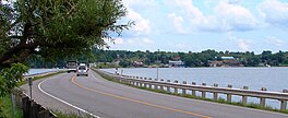
by road. This causeway is called the James A. Gifford
Causeway.
202:
33:
J. A. Gifford
Causeway with Bridgenorth on opposite shore
264:which crosses the lake, connecting Bridgenorth and
178:
174:
166:
158:
154:
143:
128:
89:
79:
69:
21:
245:Communities along and near the lakeshore include
90:
8:
425:: CS1 maint: multiple names: authors list (
18:
205:8 kilometres (5.0 mi) northwest of
361:
418:
395:
393:
391:
201:gchi-maang, meaning "big lake")" is a
184:Big Island, Goat Island, Kelly Island
7:
51:
332:or are commonly used as impromptu
197:, (pronounced "shi-MONG, from the
14:
407:. Trent Community Research Centre
50:
43:
27:
316:has caused the introduction of
165:
157:
312:. Commercial and recreational
224:Chemong is also a part of the
213:. The lake extends from near
1:
68:
447:Lakes of Peterborough County
374:Canadian Geographical Names
209:, Canada, near the town of
463:
376:. Natural Resources Canada
38:
26:
170:1 km (0.62 mi)
162:14 km (8.7 mi)
308:as well as a number of
16:Lake in Ontario, Canada
136:Harrington Narrows to
272:Tri-lake water system
230:Trent-Severn Waterway
228:water system and the
207:Peterborough, Ontario
109: /
253:on the east, and
188:
187:
113:44.400°N 78.383°W
454:
431:
430:
424:
416:
414:
412:
406:
397:
386:
385:
383:
381:
366:
132:
131:Primary outflows
124:
123:
121:
120:
119:
114:
110:
107:
106:
105:
102:
92:
54:
53:
47:
31:
19:
462:
461:
457:
456:
455:
453:
452:
451:
437:
436:
435:
434:
417:
410:
408:
404:
399:
398:
389:
379:
377:
368:
367:
363:
358:
342:
326:
290:largemouth bass
286:smallmouth bass
274:
243:
238:
215:Fowlers Corners
147: countries
118:44.400; -78.383
117:
115:
111:
108:
103:
100:
98:
96:
95:
65:
64:
63:
62:
61:
60:
59:
55:
34:
17:
12:
11:
5:
460:
458:
450:
449:
439:
438:
433:
432:
387:
370:"Chemong Lake"
360:
359:
357:
354:
341:
338:
325:
322:
273:
270:
242:
239:
237:
234:
226:Kawartha lakes
217:north to near
199:Anisnaabemowin
186:
185:
182:
176:
175:
172:
171:
168:
164:
163:
160:
156:
155:
152:
151:
148:
141:
140:
134:
126:
125:
93:
87:
86:
84:Kawartha lakes
81:
77:
76:
71:
67:
66:
57:
56:
49:
48:
42:
41:
40:
39:
36:
35:
32:
24:
23:
15:
13:
10:
9:
6:
4:
3:
2:
459:
448:
445:
444:
442:
428:
422:
403:
396:
394:
392:
388:
375:
371:
365:
362:
355:
353:
350:
346:
339:
337:
335:
331:
323:
321:
319:
318:Zebra mussels
315:
311:
307:
303:
299:
295:
291:
287:
283:
279:
278:Buckhorn Lake
271:
269:
267:
263:
258:
257:on the west.
256:
252:
248:
240:
235:
233:
231:
227:
222:
220:
216:
212:
208:
204:
200:
196:
192:
183:
181:
177:
173:
169:
161:
153:
149:
146:
142:
139:
138:Buckhorn Lake
135:
133:
127:
122:
94:
88:
85:
82:
78:
75:
72:
46:
37:
30:
25:
20:
409:. Retrieved
378:. Retrieved
373:
364:
351:
347:
343:
340:Name history
327:
324:Lake islands
298:yellow perch
275:
259:
244:
223:
195:Lake Chemong
194:
191:Chemong Lake
190:
189:
58:Chemong Lake
22:Chemong Lake
306:Muskellunge
282:Pigeon Lake
260:There is a
247:Bridgenorth
241:Communities
211:Bridgenorth
159:Max. length
116: /
91:Coordinates
356:References
219:Curve Lake
167:Max. width
380:March 19,
334:campsites
266:Ennismore
255:Ennismore
236:Geography
441:Category
421:cite web
411:19 March
330:cottages
262:causeway
70:Location
314:fishing
310:Panfish
294:walleye
180:Islands
104:78°23′W
101:44°24′N
74:Ontario
280:, and
251:Selwyn
150:Canada
405:(PDF)
193:, or
145:Basin
80:Group
427:link
413:2018
382:2018
302:Carp
203:lake
292:,
443::
423:}}
419:{{
390:^
372:.
304:,
300:,
296:,
288:,
249:,
232:.
429:)
415:.
384:.
Text is available under the Creative Commons Attribution-ShareAlike License. Additional terms may apply.