209:
108:
93:
31:
Much of the creek is diverted below ground in concrete piping. It is a few meters at the widest and is at a depth suitable for wading (not recommended due to pollution). The flow rate and volume of the creek changes with the seasons - The spring thaw yields the greatest flow. The creek contains no
69:
The
Western Falls is visible from the Radial Trail (a gravel road suitable for pedestrian and bicyclists, no motor vehicles), just west of the Upper Paradise Street stairs and the Chedoke clubhouse. From the falls, the creek is routed under the radial trail and travels through a thin stretch of
70:
forest that separates the
Chedoke Civic Golf Course from the nearby houses. At Glenside Avenue (approximately 500 meters from the Radial Trail), the creek is routed underground. It is channeled through a built concrete trough along the side of
63:, locally referred to as "The Mountain." Both falls are located in a stretch of parkland, The Mountain Brow. The larger falls is secluded, located at the east entrance of the
250:
44:. Biodiversity is considered an indicator of health. Low biodiversity indicates pollution. Testing performed by McMaster students have detected a high
107:
92:
184:
269:
67:
and requires a dangerous hike along a steeply-inclined valley that shows bright red clay soils and an abundance of mature maple trees.
243:
274:
236:
48:
count, indicating that the waters are unsafe for all humans and pets - though much less so than the East
Hamilton's
41:
64:
152:
71:
132:
37:
208:
181:
142:
60:
21:
137:
45:
188:
157:
75:
220:
147:
49:
263:
127:
98:
56:
33:
25:
216:
36:, as part of an educational program organized by Dr. George Sorger of
113:
Lower falls of the
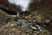
Chedoke Creek in Hamilton, Ontario Canada
224:
20:
is an urban creek that runs through the west end of
101:(Upper) height 15.5 m (51 ft), width 2 m (6.6 ft)
244:
8:
251:
237:
191:. McMaster University Biology Dept. (2008)
182:Point Source Pollution of Hamilton Harbour
32:fish stock, but has tested for watershed
177:
175:
173:
169:
88:
7:
215:This article related to a river in
205:
203:
14:
207:
106:
91:
40:for the benefit of students at
1:
223:. You can help Knowledge by
270:Rivers of Hamilton, Ontario
291:
202:
65:Chedoke Civic Golf Course
55:Two separate waterfalls (
42:Westdale Secondary School
78:at Princess Point Park.
153:Red Hill Valley Parkway
28:and the Radial Trail.
187:May 22, 2009, at the
83:Chedoke Creek Gallery
275:Ontario river stubs
38:McMaster University
143:Chedoke Expressway
61:Niagara Escarpment
24:. It crosses the
232:
231:
133:Chedoke Golf Club
74:and empties into
22:Hamilton, Ontario
282:
253:
246:
239:
211:
204:
192:
179:
138:Chedoke Hospital
110:
95:
59:) flow over the
290:
289:
285:
284:
283:
281:
280:
279:
260:
259:
258:
257:
200:
196:
195:
189:Wayback Machine
180:
171:
166:
158:Cootes Paradise
124:
119:
118:
117:
114:
111:
102:
96:
85:
84:
76:Cootes Paradise
68:
12:
11:
5:
288:
286:
278:
277:
272:
262:
261:
256:
255:
248:
241:
233:
230:
229:
219:, Canada is a
212:
194:
193:
168:
167:
165:
162:
161:
160:
155:
150:
148:Red Hill Creek
145:
140:
135:
130:
123:
120:
116:
115:
112:
105:
103:
97:
90:
87:
86:
82:
81:
80:
50:Red Hill Creek
13:
10:
9:
6:
4:
3:
2:
287:
276:
273:
271:
268:
267:
265:
254:
249:
247:
242:
240:
235:
234:
228:
226:
222:
218:
213:
210:
206:
201:
198:
190:
186:
183:
178:
176:
174:
170:
163:
159:
156:
154:
151:
149:
146:
144:
141:
139:
136:
134:
131:
129:
128:Chedoke Falls
126:
125:
121:
109:
104:
100:
99:Chedoke Falls
94:
89:
79:
77:
73:
66:
62:
58:
57:Chedoke Falls
53:
51:
47:
43:
39:
35:
29:
27:
23:
19:
18:Chedoke Creek
225:expanding it
214:
199:
197:
54:
34:biodiversity
30:
17:
15:
72:Highway 403
26:Bruce Trail
264:Categories
164:References
185:Archived
122:See also
217:Ontario
46:E. coli
221:stub
16:The
266::
172:^
52:.
252:e
245:t
238:v
227:.
Text is available under the Creative Commons Attribution-ShareAlike License. Additional terms may apply.