626:
59:
659:
92:
722:
679:
42:
550:
567:
542:
525:
99:
66:
257:
424:
dating from 1741 can be found adjacent to the church wall on St. Cuthbert's Road close to
Botanic Gardens. The centre of the old village retains much of its character from bygone ages - with the green in front of St Cuthbert's Church flanked by the two local pubs - the Bold Arms and the Hesketh Arms.
790:
runs through the north of the village and is considered by some local people to be the boundary of
Churchtown and Marshside. There are many bus stops throughout the village and local area which link to all over the Southport area and suburbs, with services extending into Liverpool, West Lancashire,
708:
Closed 2012 as a result of government national budgetary cuts. Contents removed and dispersed. Some contents remain under the control of
Merseyside Museums, and the dug-out canoe formerly in the Museum was placed in the Atkinson, Southport Town Centre in 2014 after preservation
758:
Other amenities in the
Churchtown include: Two Bakeries, Subway (Sandwich shop), Garden Centre, Antiques Shops, Two DIY shops, Three Take-Away Shops, Two Florists, Two Furniture Shops, Three Cafes, Printer Shops, Two Beauty Shops and many more smaller shops.
712:
Library. Closed 2014 as a result of government national budgetary cuts. The library building was demolished shortly after closure, probably because it was largely of wooden construction and so at particular risk of vandalism and
1436:
447:
which means the village can be susceptible to flooding during heavy rainfall. There are embankments to the north of nearby
Marshside and there are drainage systems across the area, the closest being the
413:
In 1575, a shipwreck occurred off the
Churchtown coast, the cargo of which contained potatoes, was washed ashore. Subsequently, the village became the first place in England where they were grown.
440:
To the North of
Churchtown, is Crossens, which is the most northerly suburb of Southport. To the west of Churchtown is Marshside, to the east High Park, and to the south is the Hesketh Park area.
437:
Churchtown is situated in North West
England. The closest cities are Preston to the north east and Liverpool to the south. Churchtown is a suburb of Southport which has the nearest town centre.
1070:
297:
161:
134:
425:
This is covered by a preservation order which covers much of
Botanic Road, where some thatched cottages still exist. On one side of the Hesketh Arms is the entrance to
281:
476:
443:
The village is one of many villages on the West
Lancashire Coastal Plain, most of the village is only slightly above sea-level just like the nearby village of
1063:
800:
58:
1056:
243:
341:
305:
961:
269:
91:
605:
Churchtown has one primary school (Churchtown Primary School) which is situated on St Cuthbert's Road and access is also available via
469:
274:
637:
610:
820:
323:
924:
231:
197:
1080:
617:
in February 2010 as "outstanding" (grade 1). In 2017, there was a further short inspection and the school was rated "good"
151:
1124:
462:
127:
333:
286:
1380:
909:
775:
625:
929:
705:
701:
606:
328:
211:
1007:
1048:
954:
779:
613:. It is among the ten biggest primary schools in the country, with nearly 900 pupils, and was described by
893:
1410:
1199:
449:
1249:
1234:
1169:
1027:
1012:
501:
394:
846:
670:
Corner Surgery - closed in 2006 and moved to a new surgery situated on the Co-op Complex in Marshside.
658:
1325:
1315:
1289:
1284:
1274:
1259:
1179:
1174:
1037:
1017:
452:
to the East of the village which is controlled by the pumping station at the Banks/ Crossens border.
143:
1365:
1239:
783:
1431:
1390:
1264:
1254:
1139:
947:
187:
179:
721:
678:
1400:
1395:
1360:
1350:
514:
444:
398:
262:
609:
The school is a "community school" (i.e. not a church school) but is closely associated with
1345:
1320:
1149:
454:
236:
1375:
1310:
1305:
1194:
1189:
1022:
420:
system, and evidence can be seen in the large turning circle at the front of the gardens.
1385:
1355:
826:
41:
1425:
1405:
1214:
1209:
1184:
1114:
881:
690:
46:
Bold Arms pub on Botanic Road, looking towards the Hesketh Arms pub and village green
1370:
1335:
1330:
1164:
17:
919:
1340:
1129:
646:
Marshside Road Methodist Church - on the border between Churchtown and Marshside
586:
402:
1204:
1159:
426:
386:
382:
169:
112:
356:
343:
1269:
1244:
1032:
971:
787:
576:
556:
534:
496:
378:
221:
767:
Southport Old Links is a golf Course situated to the south of the village.
1279:
1144:
1104:
1094:
1002:
987:
982:
510:
505:
390:
1229:
1224:
1109:
1099:
992:
939:
869:
581:
203:
1154:
1119:
614:
421:
847:
https://reports.ofsted.gov.uk/provider/files/2733805/urn/104861.pdf
416:
The Botanic Gardens was at one time the terminus for the Southport
720:
677:
657:
624:
857:
643:
Churchtown United Reformed Church - Non-Conformist - Botanic Road
1219:
934:
914:
417:
1052:
943:
458:
1437:
Towns and villages in the Metropolitan Borough of Sefton
1298:
1087:
296:
280:
268:
256:
242:
230:
220:
210:
196:
178:
160:
142:
126:
34:
405:on the northern fringe of what is now Southport.
1064:
955:
470:
8:
925:Lancashire Churches: Churchtown St. Cuthbert
629:St Cuthberts Church from the Grave Yard 2008
825:, North Meols Civic Society, archived from
1071:
1057:
1049:
962:
948:
940:
858:The Parish Church of St Cuthbert Southport
801:Listed buildings in Churchtown, Merseyside
649:St Patrick Catholic Church, Marshside Road
477:
463:
455:
31:
930:Sefton Council: Southport Botanic Gardens
485:Places adjacent to Churchtown, Merseyside
812:
640:- Church of England - St Cuthberts Road
295:
251:
219:
195:
125:
38:
882:Cornerstone Methodist Church Southport
920:North Meols Civic Society: Churchtown
279:
267:
255:
241:
229:
209:
177:
159:
141:
7:
492:
98:
65:
25:
565:
548:
540:
523:
97:
90:
64:
57:
40:
786:. The line closed in 1964. The
751:One podiatry/chiropody practice
1081:Metropolitan Borough of Sefton
633:The village has four churches
429:, home of the Hesketh family.
1:
566:
524:
682:Churchtown Conservative Club
549:
541:
1079:Districts and wards of the
915:St Cuthberts Church Website
385:, England. Historically in
128:OS grid reference
29:Human settlement in England
1453:
894:St Patrick Catholic Church
776:Churchtown railway station
719:Hesketh Arms Public House
687:Churchtown Dental Practice
978:
935:Churchtown Primary School
896:, accessed 19 August 2021
884:, accessed 19 August 2021
872:, accessed 19 August 2021
870:Churchtown Village Church
860:, accessed 19 August 2021
742:A jewellers / repair shop
698:Six Hairdressers/ Barbers
667:Churchtown Medical Centre
490:
401:in the ancient parish of
314:
292:
252:
144:Metropolitan borough
51:
39:
822:Churchtown Village Trail
162:Metropolitan county
780:West Lancashire Railway
730:Bold Arms Public House
726:
683:
663:
630:
389:, it is surrounded by
232:Postcode district
117:Show map of Merseyside
736:A Veterinary Practice
724:
695:Two Spar Off Licences
681:
661:
628:
81:Show map of Southport
78:Location in Southport
1381:Netherton and Orrell
676:A Conservative Club
662:Botanic Gardens Cafe
638:St Cuthbert's Church
611:St Cuthbert's Church
450:Three Pools Waterway
212:Sovereign state
353: /
910:Churchtown Website
778:was a stop on the
733:A Funeral Director
727:
684:
664:
631:
357:53.6596°N 2.9787°W
298:UK Parliament
244:Dialling code
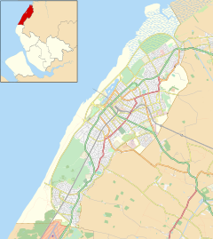
18:Churchtown, Sefton
1419:
1418:
1125:Brighton-le-Sands
1046:
1045:
754:One reflexologist
716:Churchtown Garage
597:
596:
592:
591:
372:
371:
16:(Redirected from
1444:
1073:
1066:
1059:
1050:
964:
957:
950:
941:
897:
891:
885:
879:
873:
867:
861:
855:
849:
844:
838:
837:
836:
834:
817:
782:to Crossens and
748:Three Solicitors
725:Hesketh Arms Pub
569:
568:
552:
551:
544:
543:
527:
526:
493:
479:
472:
465:
456:
368:
367:
365:
364:
363:
362:53.6596; -2.9787
358:
354:
351:
350:
349:
346:
320:
206:
138:
137:
118:
111:Location within
101:
100:
94:
82:
68:
67:
61:
44:
32:
21:
1452:
1451:
1447:
1446:
1445:
1443:
1442:
1441:
1422:
1421:
1420:
1415:
1294:
1190:Kennessee Green
1083:
1077:
1047:
1042:
974:
968:
906:
901:
900:
892:
888:
880:
876:
868:
864:
856:
852:
845:
841:
832:
830:
819:
818:
814:
809:
797:
773:
765:
706:Botanic Gardens
656:
654:Public Services
623:
621:Religious sites
607:Botanic Gardens
603:
598:
593:
553:
486:
483:
435:
411:
377:is a suburb of
361:
359:
355:
352:
347:
344:
342:
340:
339:
338:
318:
310:
202:
192:
174:
156:
133:
132:
122:
121:
120:
119:
116:
115:
109:
108:
107:
106:
102:
85:
84:
83:
80:
79:
76:
75:
74:
73:
69:
47:
30:
23:
22:
15:
12:
11:
5:
1450:
1448:
1440:
1439:
1434:
1424:
1423:
1417:
1416:
1414:
1413:
1408:
1403:
1398:
1393:
1388:
1383:
1378:
1373:
1368:
1363:
1358:
1353:
1348:
1343:
1338:
1333:
1328:
1323:
1318:
1313:
1308:
1302:
1300:
1296:
1295:
1293:
1292:
1287:
1282:
1277:
1272:
1267:
1262:
1257:
1252:
1247:
1242:
1237:
1232:
1227:
1222:
1217:
1212:
1207:
1202:
1197:
1192:
1187:
1182:
1177:
1172:
1167:
1162:
1157:
1152:
1147:
1142:
1137:
1132:
1127:
1122:
1117:
1112:
1107:
1102:
1097:
1091:
1089:
1085:
1084:
1078:
1076:
1075:
1068:
1061:
1053:
1044:
1043:
1041:
1040:
1035:
1030:
1025:
1020:
1015:
1010:
1005:
1000:
995:
990:
985:
979:
976:
975:
969:
967:
966:
959:
952:
944:
938:
937:
932:
927:
922:
917:
912:
905:
904:External links
902:
899:
898:
886:
874:
862:
850:
839:
811:
810:
808:
805:
804:
803:
796:
793:
772:
769:
764:
761:
756:
755:
752:
749:
746:
743:
740:
737:
734:
731:
728:
717:
714:
710:
704:- Situated in
699:
696:
693:
688:
685:
674:
673:Two Pharmacies
671:
668:
655:
652:
651:
650:
647:
644:
641:
622:
619:
602:
599:
595:
594:
590:
589:
584:
579:
573:
572:
570:
563:
560:
559:
554:
539:
537:
531:
530:
528:
521:
518:
517:
508:
499:
491:
488:
487:
484:
482:
481:
474:
467:
459:
434:
431:
410:
407:
370:
369:
337:
336:
331:
326:
321:
319:List of places
315:
312:
311:
309:
308:
302:
300:
294:
293:
290:
289:
284:
278:
277:
272:
266:
265:
260:
254:
253:
250:
249:
246:
240:
239:
234:
228:
227:
224:
218:
217:
216:United Kingdom
214:
208:
207:
200:
194:
193:
191:
190:
184:
182:
176:
175:
173:
172:
166:
164:
158:
157:
155:
154:
148:
146:
140:
139:
130:
124:
123:
110:
104:
103:
96:
95:
89:
88:
87:
86:
77:
71:
70:
63:
62:
56:
55:
54:
53:
52:
49:
48:
45:
37:
36:
28:
24:
14:
13:
10:
9:
6:
4:
3:
2:
1449:
1438:
1435:
1433:
1430:
1429:
1427:
1412:
1409:
1407:
1404:
1402:
1399:
1397:
1394:
1392:
1389:
1387:
1384:
1382:
1379:
1377:
1374:
1372:
1369:
1367:
1364:
1362:
1359:
1357:
1354:
1352:
1349:
1347:
1344:
1342:
1339:
1337:
1334:
1332:
1329:
1327:
1324:
1322:
1319:
1317:
1316:Blundellsands
1314:
1312:
1309:
1307:
1304:
1303:
1301:
1299:Council Wards
1297:
1291:
1288:
1286:
1283:
1281:
1278:
1276:
1273:
1271:
1268:
1266:
1263:
1261:
1258:
1256:
1253:
1251:
1248:
1246:
1243:
1241:
1238:
1236:
1233:
1231:
1228:
1226:
1223:
1221:
1218:
1216:
1215:Little Crosby
1213:
1211:
1210:Little Altcar
1208:
1206:
1203:
1201:
1198:
1196:
1193:
1191:
1188:
1186:
1185:Ince Blundell
1183:
1181:
1178:
1176:
1173:
1171:
1168:
1166:
1163:
1161:
1158:
1156:
1153:
1151:
1148:
1146:
1143:
1141:
1138:
1136:
1133:
1131:
1128:
1126:
1123:
1121:
1118:
1116:
1115:Blundellsands
1113:
1111:
1108:
1106:
1103:
1101:
1098:
1096:
1093:
1092:
1090:
1086:
1082:
1074:
1069:
1067:
1062:
1060:
1055:
1054:
1051:
1039:
1036:
1034:
1031:
1029:
1026:
1024:
1021:
1019:
1016:
1014:
1011:
1009:
1006:
1004:
1001:
999:
996:
994:
991:
989:
986:
984:
981:
980:
977:
973:
965:
960:
958:
953:
951:
946:
945:
942:
936:
933:
931:
928:
926:
923:
921:
918:
916:
913:
911:
908:
907:
903:
895:
890:
887:
883:
878:
875:
871:
866:
863:
859:
854:
851:
848:
843:
840:
829:on 9 May 2008
828:
824:
823:
816:
813:
806:
802:
799:
798:
794:
792:
791:and Preston.
789:
785:
781:
777:
770:
768:
762:
760:
753:
750:
747:
744:
741:
738:
735:
732:
729:
723:
718:
715:
711:
707:
703:
700:
697:
694:
692:
691:Tesco Express
689:
686:
680:
675:
672:
669:
666:
665:
660:
653:
648:
645:
642:
639:
636:
635:
634:
627:
620:
618:
616:
612:
608:
600:
588:
585:
583:
580:
578:
575:
574:
571:
564:
562:
561:
558:
555:
547:
538:
536:
533:
532:
529:
522:
520:
519:
516:
512:
509:
507:
503:
500:
498:
495:
494:
489:
480:
475:
473:
468:
466:
461:
460:
457:
453:
451:
446:
441:
438:
432:
430:
428:
423:
419:
414:
408:
406:
404:
400:
396:
392:
388:
384:
380:
376:
366:
335:
332:
330:
327:
325:
322:
317:
316:
313:
307:
304:
303:
301:
299:
291:
288:
285:
283:
276:
273:
271:
264:
261:
259:
247:
245:
238:
235:
233:
225:
223:
215:
213:
205:
201:
199:
189:
186:
185:
183:
181:
171:
168:
167:
165:
163:
153:
150:
149:
147:
145:
136:
131:
129:
114:
93:
60:
50:
43:
33:
27:
19:
1165:Great Crosby
1134:
1008:Hesketh Park
997:
889:
877:
865:
853:
842:
831:, retrieved
827:the original
821:
815:
774:
766:
757:
632:
604:
545:
442:
439:
436:
415:
412:
374:
373:
26:
1130:Carr Houses
970:Suburbs of
745:A newsagent
739:An Optician
587:Scarisbrick
403:North Meols
360: /
1426:Categories
1401:St. Oswald
1396:Ravenmeols
1361:Litherland
1205:Litherland
1200:Lady Green
1160:Freshfield
1135:Churchtown
998:Churchtown
807:References
709:treatment.
546:Churchtown
427:Meols Hall
387:Lancashire
383:Merseyside
375:Churchtown
345:53°39′35″N
334:Merseyside
287:North West
275:Merseyside
263:Merseyside
188:North West
170:Merseyside
113:Merseyside
105:Churchtown
72:Churchtown
35:Churchtown
1432:Southport
1346:Harington
1321:Cambridge
1270:Southport
1250:Netherton
1245:Meols Cop
1235:Marshside
1170:High Park
1088:Districts
1033:Meols Cop
1028:Marshside
1013:High Park
972:Southport
788:A565 road
771:Transport
601:Education
577:Southport
557:Mere Brow
535:Southport
502:Marshside
497:Irish Sea
433:Geography
399:Marshside
395:High Park
379:Southport
348:2°58′43″W
306:Southport
282:Ambulance
226:SOUTHPORT
222:Post town
1411:Victoria
1376:Molyneux
1311:Birkdale
1306:Ainsdale
1290:Woodvale
1285:Waterloo
1280:Waddicar
1275:Thornton
1260:Seaforth
1180:Hillside
1175:Hightown
1145:Crossens
1105:Birkdale
1095:Ainsdale
1038:Woodvale
1018:Hillside
1003:Crossens
988:Birkdale
983:Ainsdale
795:See also
511:Crossens
506:Crossens
391:Crossens
135:SD365186
1386:Norwood
1356:Linacre
1240:Melling
1230:Maghull
1225:Lydiate
1110:Blowick
1100:Aintree
993:Blowick
833:2 April
784:Preston
763:Leisure
582:Blowick
409:History
329:England
204:England
198:Country
1406:Sudell
1326:Church
1265:Sefton
1255:Orrell
1155:Formby
1140:Crosby
1120:Bootle
702:Museum
615:OFSTED
422:Stocks
258:Police
180:Region
152:Sefton
1371:Meols
1366:Manor
1336:Dukes
1331:Derby
713:fire.
515:Banks
445:Banks
248:01704
1391:Park
1341:Ford
1220:Lunt
1150:Ford
835:2008
418:tram
397:and
270:Fire
1351:Kew
1195:Kew
1023:Kew
237:PR9
1428::
513:,
504:,
393:,
381:,
324:UK
1072:e
1065:t
1058:v
963:e
956:t
949:v
478:e
471:t
464:v
20:)
Text is available under the Creative Commons Attribution-ShareAlike License. Additional terms may apply.