68:
53:
80:
767:
180:
390:
In the township the population was spread out, with 25.2% under the age of 18, 7.7% from 18 to 24, 31.1% from 25 to 44, 23.4% from 45 to 64, and 12.5% who were 65 years of age or older. The median age was 38 years. For every 100 females, there were 98.9 males. For every 100 females age 18 and over,
386:
There were 917 households, out of which 37.0% had children under the age of 18 living with them, 62.7% were married couples living together, 8.6% had a female householder with no husband present, and 23.9% were non-families. 19.8% of all households were made up of individuals, and 5.9% had someone
378:, there were 2,705 people, 917 households, and 697 families residing in the township. The population density was 115.8 inhabitants per square mile (44.7/km). There were 958 housing units at an average density of 41.0 per square mile (15.8/km). The
67:
382:
of the township was 98.82% White, 0.22% African
American, 0.18% Native American, 0.07% Asian, 0.18% from other races, and 0.52% from two or more races. Hispanic or Latino of any race were 0.52% of the population.
1282:
52:
394:
The median income for a household in the township was $ 35,208, and the median income for a family was $ 42,375. Males had a median income of $ 30,682 versus $ 20,714 for females. The
968:
705:
1048:
17:
1331:
1063:
1023:
1008:
1003:
973:
918:
993:
983:
379:
79:
1321:
1058:
1033:
998:
988:
978:
963:
958:
928:
1053:
1013:
943:
938:
933:
1073:
923:
913:
1043:
948:
514:
698:
237:
1156:
607:
1151:
1326:
825:
645:
691:
587:
1336:
1028:
1111:
438:
212:
112:
1068:
683:
468:
1101:
1126:
1106:
415:
269:
1146:
1038:
1018:
805:
619:
387:
living alone who was 65 years of age or older. The average household size was 2.77 and the average family size was 3.15.
1259:
875:
795:
715:
566:
411:
288:
257:
117:
518:
1221:
890:
885:
870:
855:
835:
810:
375:
340:
325:
515:"Geographic Identifiers: 2010 Demographic Profile Data (G001): Clearfield township, Butler County, Pennsylvania"
895:
840:
820:
815:
277:
90:
1231:
1216:
1181:
1136:
1116:
1083:
905:
865:
253:
43:
1121:
1096:
880:
860:
850:
777:
1236:
1206:
1201:
1191:
1141:
830:
800:
790:
1266:
1226:
1211:
1196:
1091:
756:
737:
281:
222:
1186:
1176:
1166:
1131:
785:
748:
845:
594:
398:
for the township was $ 14,952. About 5.9% of families and 10.8% of the population were below the
540:
488:
395:
421:
The district formerly operated
Clearfield Township Elementary School, which closed in 2015.
500:
678:
273:
57:
1315:
399:
105:
730:
291:, the township has a total area of 23.6 square miles (61.2 km), all land.
272:
border. It contains the unincorporated communities of
Coyleville and Fenelton.
100:
1297:
1284:
203:
623:
402:, including 9.5% of those under age 18 and 11.9% of those age 65 or over.
1250:‡This populated place also has portions in an adjacent county or counties
649:
653:
72:
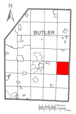
Map of Butler County, Pennsylvania, highlighting
Clearfield Township
268:
Clearfield
Township is located in eastern Butler County, along the
646:"Residents Upset With Butler District's Decision To Close Schools"
229:
208:
588:"2020 CENSUS - SCHOOL DISTRICT REFERENCE MAP: Butler County, PA"
687:
260:, United States. The population was 2,430 at the 2020 census.
765:
562:
517:. U.S. Census Bureau, American Factfinder. Archived from
16:
462:
460:
458:
456:
418:
are the district's comprehensive secondary schools.
1245:
1165:
1082:
904:
776:
747:
236:
219:
202:
194:
186:
173:
168:
160:
152:
144:
139:
131:
123:
111:
99:
89:
30:
18:Clearfield Township, Pennsylvania (disambiguation)
699:
622:. Butler Area School District. Archived from
276:passes through the township, leading east to
8:
469:"City and Town Population Totals: 2020-2022"
414:. Butler Area Intermediate High School and
706:
692:
684:
298:
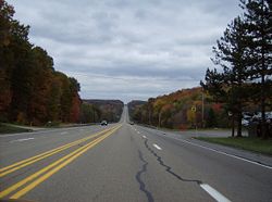
60:in the wooded hills of Clearfield Township
27:
1332:Townships in Butler County, Pennsylvania
430:
235:
201:
167:
138:
122:
88:
64:
49:
25:Township in Pennsylvania, United States
496:
486:
318:
218:
193:
185:
172:
159:
156:23.64 sq mi (61.23 km)
151:
148:23.64 sq mi (61.23 km)
143:
130:
110:
98:
76:
7:
1322:Populated places established in 1798
679:Early history of Clearfield Township
164:0.00 sq mi (0.01 km)
714:Municipalities and communities of
541:"Census of Population and Housing"
308:
84:Map of Butler County, Pennsylvania
14:
179:
178:
78:
66:
51:
416:Butler Area Senior High School
1:
441:. United States Census Bureau
1327:Pittsburgh metropolitan area
198:109.01/sq mi (42.09/km)
717:Butler County, Pennsylvania
567:United States Census Bureau
439:"2016 U.S. Gazetteer Files"
412:Butler Area School District
289:United States Census Bureau
258:Butler County, Pennsylvania
187: • Estimate
1353:
15:
1337:Townships in Pennsylvania
1255:
763:
728:
367:
354:
339:
324:
317:
312:
307:
304:
77:
65:
50:
41:
1152:Slippery Rock University
391:there were 99.4 males.
770:
1298:40.83333°N 79.76639°W
769:
620:"Butler Area Schools"
563:"U.S. Census website"
368:U.S. Decennial Census
300:Historical population
221: • Summer (
1268:United States portal
521:on February 12, 2020
195: • Density
32:Clearfield Township,
1303:40.83333; -79.76639
1294: /
1261:Pennsylvania portal
1112:Lake Arthur Estates
467:Bureau, US Census.
301:
250:Clearfield Township
771:
595:U.S. Census Bureau
499:has generic name (
475:. US Census Bureau
299:
174: • Total
161: • Water
145: • Total
1277:
1276:
626:on April 13, 1997
396:per capita income
372:
371:
287:According to the
247:
246:
153: • Land
1344:
1309:
1308:
1306:
1305:
1304:
1299:
1295:
1292:
1291:
1290:
1287:
1269:
1262:
1127:North Washington
1107:Homeacre-Lyndora
768:
740:
733:
723:
718:
708:
701:
694:
685:
666:
665:
663:
661:
642:
636:
635:
633:
631:
616:
610:
605:
603:
601:
592:
584:
578:
577:
575:
573:
559:
553:
552:
550:
548:
537:
531:
530:
528:
526:
511:
505:
504:
498:
494:
492:
484:
482:
480:
464:
451:
450:
448:
446:
435:
320:
315:
310:
302:
270:Armstrong County
226:
182:
181:
82:
70:
55:
28:
1352:
1351:
1347:
1346:
1345:
1343:
1342:
1341:
1312:
1311:
1302:
1300:
1296:
1293:
1288:
1285:
1283:
1281:
1280:
1278:
1273:
1267:
1260:
1251:
1241:
1168:
1161:
1147:Shanor-Northvue
1078:
969:Connoquenessing
900:
806:Connoquenessing
772:
766:
761:
743:
738:
731:
724:
721:
716:
712:
675:
670:
669:
659:
657:
644:
643:
639:
629:
627:
618:
617:
613:
599:
597:
590:
586:
585:
581:
571:
569:
561:
560:
556:
546:
544:
539:
538:
534:
524:
522:
513:
512:
508:
495:
485:
478:
476:
466:
465:
454:
444:
442:
437:
436:
432:
427:
408:
313:
297:
266:
220:
85:
73:
61:
46:
37:
35:
33:
26:
21:
12:
11:
5:
1350:
1348:
1340:
1339:
1334:
1329:
1324:
1314:
1313:
1275:
1274:
1272:
1271:
1264:
1256:
1253:
1252:
1249:
1247:
1243:
1242:
1240:
1239:
1234:
1229:
1224:
1219:
1214:
1209:
1204:
1199:
1194:
1189:
1184:
1179:
1173:
1171:
1167:Unincorporated
1163:
1162:
1160:
1159:
1154:
1149:
1144:
1139:
1134:
1129:
1124:
1119:
1114:
1109:
1104:
1099:
1094:
1088:
1086:
1080:
1079:
1077:
1076:
1071:
1066:
1061:
1056:
1051:
1046:
1041:
1036:
1031:
1026:
1021:
1016:
1011:
1006:
1001:
996:
991:
986:
981:
976:
971:
966:
961:
956:
951:
946:
941:
936:
931:
926:
921:
916:
910:
908:
902:
901:
899:
898:
893:
888:
883:
878:
873:
868:
863:
858:
853:
848:
843:
838:
833:
828:
823:
818:
813:
808:
803:
798:
793:
788:
782:
780:
774:
773:
764:
762:
760:
759:
753:
751:
745:
744:
729:
726:
725:
713:
711:
710:
703:
696:
688:
682:
681:
674:
673:External links
671:
668:
667:
637:
611:
579:
554:
532:
506:
452:
429:
428:
426:
423:
407:
404:
370:
369:
365:
364:
361:
359:
356:
352:
351:
348:
346:
343:
337:
336:
333:
331:
328:
322:
321:
316:
311:
306:
296:
293:
274:U.S. Route 422
265:
262:
245:
244:
241:
234:
233:
227:
217:
216:
206:
200:
199:
196:
192:
191:
188:
184:
183:
175:
171:
170:
166:
165:
162:
158:
157:
154:
150:
149:
146:
142:
141:
137:
136:
133:
129:
128:
125:
121:
120:
115:
109:
108:
103:
97:
96:
93:
87:
86:
83:
75:
74:
71:
63:
62:
58:U.S. Route 422
56:
48:
47:
42:
39:
38:
34:Butler County,
31:
24:
13:
10:
9:
6:
4:
3:
2:
1349:
1338:
1335:
1333:
1330:
1328:
1325:
1323:
1320:
1319:
1317:
1310:
1307:
1270:
1265:
1263:
1258:
1257:
1254:
1248:
1244:
1238:
1235:
1233:
1230:
1228:
1225:
1223:
1220:
1218:
1215:
1213:
1210:
1208:
1205:
1203:
1200:
1198:
1195:
1193:
1190:
1188:
1185:
1183:
1180:
1178:
1175:
1174:
1172:
1170:
1164:
1158:
1155:
1153:
1150:
1148:
1145:
1143:
1140:
1138:
1135:
1133:
1130:
1128:
1125:
1123:
1120:
1118:
1115:
1113:
1110:
1108:
1105:
1103:
1100:
1098:
1095:
1093:
1090:
1089:
1087:
1085:
1081:
1075:
1072:
1070:
1067:
1065:
1062:
1060:
1057:
1055:
1052:
1050:
1049:Slippery Rock
1047:
1045:
1042:
1040:
1037:
1035:
1032:
1030:
1027:
1025:
1022:
1020:
1017:
1015:
1012:
1010:
1007:
1005:
1002:
1000:
997:
995:
992:
990:
987:
985:
982:
980:
977:
975:
972:
970:
967:
965:
962:
960:
957:
955:
952:
950:
947:
945:
942:
940:
937:
935:
932:
930:
927:
925:
922:
920:
917:
915:
912:
911:
909:
907:
903:
897:
894:
892:
889:
887:
884:
882:
879:
877:
876:Slippery Rock
874:
872:
869:
867:
864:
862:
859:
857:
854:
852:
849:
847:
844:
842:
839:
837:
834:
832:
829:
827:
824:
822:
819:
817:
814:
812:
809:
807:
804:
802:
799:
797:
796:Cherry Valley
794:
792:
789:
787:
784:
783:
781:
779:
775:
758:
755:
754:
752:
750:
746:
742:
741:
734:
727:
722:United States
719:
709:
704:
702:
697:
695:
690:
689:
686:
680:
677:
676:
672:
656:. May 7, 2015
655:
651:
647:
641:
638:
625:
621:
615:
612:
609:
596:
589:
583:
580:
568:
564:
558:
555:
542:
536:
533:
520:
516:
510:
507:
502:
490:
474:
470:
463:
461:
459:
457:
453:
440:
434:
431:
424:
422:
419:
417:
413:
410:It is in the
405:
403:
401:
397:
392:
388:
384:
381:
380:racial makeup
377:
366:
362:
360:
357:
353:
349:
347:
344:
342:
338:
334:
332:
329:
327:
323:
303:
294:
292:
290:
285:
283:
279:
275:
271:
263:
261:
259:
255:
251:
242:
239:
231:
228:
224:
214:
213:Eastern (EST)
210:
207:
205:
197:
189:
176:
163:
155:
147:
134:
126:
119:
116:
114:
107:
104:
102:
95:United States
94:
92:
81:
69:
59:
54:
45:
40:
29:
23:
19:
1279:
1222:Murrinsville
953:
891:West Sunbury
886:West Liberty
871:Seven Fields
856:Portersville
736:
658:. Retrieved
640:
628:. Retrieved
624:the original
614:
598:. Retrieved
582:
570:. Retrieved
557:
545:. Retrieved
543:. Census.gov
535:
523:. Retrieved
519:the original
509:
497:|last1=
477:. Retrieved
472:
443:. Retrieved
433:
420:
409:
400:poverty line
393:
389:
385:
373:
295:Demographics
286:
280:and west to
267:
249:
248:
243:42-019-14048
132:Incorporated
106:Pennsylvania
36:Pennsylvania
22:
1301: /
1169:communities
1102:Forestville
1029:Muddy Creek
836:Harrisville
811:East Butler
732:County seat
572:January 31,
376:2000 census
355:2022 (est.)
1316:Categories
1289:79°45′59″W
1286:40°50′00″N
1157:Unionville
1064:Washington
954:Clearfield
896:Zelienople
841:Karns City
821:Evans City
816:Eau Claire
473:Census.gov
445:August 13,
425:References
374:As of the
278:Kittanning
169:Population
1246:Footnotes
1232:Wahlville
1217:Hilliards
1182:Branchton
1137:Oak Hills
1117:Meadowood
1024:Middlesex
1009:Lancaster
1004:Jefferson
974:Cranberry
919:Allegheny
906:Townships
866:Saxonburg
608:Text list
525:March 27,
406:Education
264:Geography
204:Time zone
1122:Meridian
1097:Fenelton
1069:Winfield
994:Franklin
984:Fairview
881:Valencia
861:Prospect
851:Petrolia
826:Fairview
778:Boroughs
660:July 15,
650:CBS News
630:July 15,
600:July 15,
489:cite web
479:June 19,
254:township
44:Township
1237:Watters
1207:Fox Run
1202:Fernway
1192:Eidenau
1142:Renfrew
1059:Venango
1034:Oakland
999:Jackson
989:Forward
979:Donegal
964:Concord
959:Clinton
929:Buffalo
831:Harmony
801:Chicora
791:Callery
654:KDKA-TV
547:June 4,
124:Settled
91:Country
1227:Sarver
1212:Herman
1197:Euclid
1092:Boyers
1054:Summit
1039:Parker
1019:Mercer
1014:Marion
944:Cherry
939:Center
934:Butler
757:Butler
739:Butler
305:Census
282:Butler
177:2,430
118:Butler
113:County
1187:Cabot
1177:Bonus
1132:Nixon
1074:Worth
924:Brady
914:Adams
786:Bruin
591:(PDF)
363:−2.1%
358:2,379
350:−8.1%
345:2,430
330:2,645
252:is a
232:(EDT)
230:UTC-4
209:UTC-5
190:2,379
101:State
1084:CDPs
1044:Penn
949:Clay
846:Mars
749:City
662:2024
632:2024
602:2024
574:2008
549:2016
527:2014
501:help
481:2023
447:2017
341:2020
326:2010
314:Note
309:Pop.
240:code
238:FIPS
140:Area
135:1804
127:1798
256:in
223:DST
1318::
735::
720:,
652:.
648:.
606:-
593:.
565:.
493::
491:}}
487:{{
471:.
455:^
319:%±
284:.
707:e
700:t
693:v
664:.
634:.
604:.
576:.
551:.
529:.
503:)
483:.
449:.
335:—
225:)
215:)
211:(
20:.
Text is available under the Creative Commons Attribution-ShareAlike License. Additional terms may apply.