226:
264:
45:
52:
29:
267:
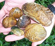
Endangered freshwater mussels. Bottom diagonal row, left to right: Cumberlandian combshell (Epioblasma brevidens), Oyster mussel (Epioblasma capsaeformis). Middle Row: Shiny pigtoe (Fusconaia cor), Birdwing pearlymussel (Lemiox rimosus), Cumberland monkeyface (Quadrula intermedia). Top row: Rough
292:
The
Plateau Province is covered by a complex forest composed of northern hardwood interspersed with conifers. The southern Appalachians contain more plant species than anywhere else in North America since the region was a refuge for many species when glaciers covered the northern part of the
305:
The Clinch Ranger
District Cluster lies within the Clinch Ranger District of the George Washington and Jefferson National Forest. To protect the headwaters of the Tennessee Valley drainage from flooding caused by timbering and the stripping of whole mountains by mining, the US Forest Service
246:
The Clinch Ranger
District lies in the Alleghany Plateau, a highly dissected plateau composed of relatively flat-lying bedrock of Mississippian and Pennsylvania age. In places the dissection is so pronounced that the area has the appearance of mountains. But compared to the Ridge and Valley
272:
Clusters of wild areas, such as the Clinch Ranger
District Cluster, are important for the maintenance of biological diversity. A natural landscape contains a blend of ecosystems—mountain slopes, moist areas, soil types, temperatures—over which species can roam in their search for mates,
284:
The bird population is also affected by the division of undisturbed forest into islands with edges defined by roads. Predators of birds, such as raccoons, snakes, skunks, house cats and egg-eating crows and blue jays, are often found at forest edges. And roads provide a pathway for
233:
The Clinch Ranger
District is divided into two parts, the northern section parallels Pine Mountain and the southern section follows Powell Mountain. US Highway 23 runs between the two sections. Other roads and trails in the area are shown on National Geographic Map 793,
254:
The horizontal layering of the
Plateau, seen in road cuts and rocky cliffs in river gorges, contrasts with the tilted up thrusts in the Ridge and Valley province on the east. Seams of high-quality coal led to mining beginning in the late 1800s.
293:
hemisphere. In modern times, game species disappeared after widespread hunting, but with the beginning of game management many species have begun to recover to the extent that animals such as black bear, deer and turkeys can be found.
2231:
296:
The watershed for the cluster contains many endangered fresh_water mussel species. The identified species has been reduced from 60 to about 40, with 26 listed by the Nature
Conservancy as globally rare.
166:
and uninventoried areas recognized by the
Wilderness Society as worthy of protection from timbering and roads. The cluster contains the following areas, all within the Clinch Ranger District of the
1442:
1246:
277:
for food, and the avoidance of predators and other stress-inducing hazards. The construction of roads breaks up the landscape into islands which limit the free migration of forest species. Such
251:
River is an example of formations in the
Plateau with almost 1000-foot-deep gorge and striking erosional features with descriptive names such as the Palisades, The Towers, and The Chimneys. .
2289:
2226:
2050:
289:
in their search for the location of nests of smaller birds, who then destroy the eggs and replace them with their own eggs leaving the unwitting owner to raise the cowbird hatchlings.
1145:
793:
723:
705:
1044:
876:
803:
994:
675:
247:
Province to the east with long uplifted ridges, the mountains are in random directions formed by the erosion of streams into deep, narrow valleys leaving rugged mountains. The
748:
1865:
2160:
1427:
2253:
1710:
1094:
1039:
846:
1950:
1117:
167:
143:
44:
2236:
1457:
1168:
733:
773:
1735:
1109:
2040:
1009:
999:
2190:
1920:
1815:
1064:
738:
503:
225:
1995:
1705:
392:
2268:
2263:
2030:
1915:
1890:
1084:
668:
2170:
2110:
2045:
2010:
1730:
1695:
97:
2165:
2055:
1940:
1885:
1805:
1755:
1178:
1099:
836:
783:
763:
696:
159:
2135:
2130:
2105:
2090:
2080:
2065:
2015:
1935:
1910:
1780:
1700:
1690:
828:
778:
743:
147:
2005:
1990:
1895:
1875:
1800:
1765:
1655:
1467:
1135:
1079:
1059:
1049:
1034:
866:
2211:
2155:
2085:
1880:
1870:
1850:
1845:
1840:
1835:
1790:
1740:
1680:
1069:
684:
661:
605:
1775:
2175:
2075:
2035:
2020:
1980:
1945:
1930:
1905:
1825:
1795:
1785:
1760:
1750:
1745:
1665:
1236:
1153:
329:
2120:
2095:
1985:
1965:
1955:
1725:
1675:
1625:
1520:
1089:
1074:
971:
818:
808:
456:
2125:
2070:
2000:
1900:
1860:
1830:
1820:
1029:
1019:
926:
758:
620:
577:
547:
2140:
1810:
1720:
1575:
1482:
1437:
1387:
1312:
1282:
339:
2258:
2185:
2145:
2100:
2060:
1975:
1770:
1158:
871:
813:
212:
207:
150:
for its rich biodiversity and rugged scenery. It offers a unique habitat for rare plants, salamanders and other rare species.
2150:
1925:
1685:
1512:
1452:
896:
891:
2115:
1855:
1605:
911:
856:
2180:
2025:
1560:
1342:
1337:
1269:
1206:
921:
851:
334:
2221:
1585:
1191:
1054:
841:
1715:
1670:
1555:
1497:
1407:
1277:
1221:
1163:
965:
916:
906:
901:
881:
861:
753:
314:
Other clusters of the
Wilderness Society's "Mountain Treasures" in the Jefferson National Forest (north to south):
75:
263:
1550:
1462:
1402:
1397:
1392:
1216:
1186:
886:
385:
177:
163:
1630:
1610:
1352:
1347:
1332:
1196:
1127:
713:
380:
354:
1635:
495:
1580:
1570:
1487:
1377:
1307:
1302:
1226:
950:
359:
349:
182:
1565:
1545:
1525:
1447:
1432:
1412:
1372:
1357:
1322:
1287:
1260:
1004:
981:
71:
1615:
1600:
1540:
1530:
1502:
1417:
1382:
1327:
79:
1640:
1595:
1492:
1472:
1367:
1362:
1297:
1211:
364:
286:
281:
have been shown to minimize the diversity required for the maintenance of a rich biological habitat.
192:
83:
1535:
1422:
344:
324:
1590:
1317:
1292:
944:
202:
539:
533:
481:
1645:
1620:
1201:
989:
616:
601:
573:
543:
452:
936:
319:
397:
643:
960:
197:
474:
2283:
1477:
567:
278:
248:
434:
Virginia's Mountain Treasures, report issued by The Wilderness Society, May, 1999
768:
613:
Where There Are Mountains, An Environmental History of the Southern Appalachians
955:
653:
638:
112:
99:
419:
A Review of the Virginia Mountain Treasures of the Jefferson National Forest
28:
688:
274:
480:. Charlottesville, Virginia: The University Press of Virginia. p.
262:
224:
657:
648:
633:
449:
Clinch Ranger District (Trails Illustrated Hiking Maps, 793)
2227:
National Register of Historic Places listings in Virginia
600:, 2013, West Virginia University Press, West Virginia,
572:. Chapel Hill: The University of North Carolina Press.
615:, 2000, University of Georgia Press, Athens, Georgia.
59:
Location of Clinch Ranger District Cluster in Virginia
51:
538:. Marietta, Georgia: Longstreet Press, Inc. pp.
421:. Blacksburg, Virginia: Sierra Club, OCLC: 893635467.
2210:
2203:
1964:
1654:
1511:
1268:
1259:
1235:
1177:
1144:
1126:
1108:
1018:
980:
935:
827:
792:
722:
704:
695:
128:
91:
67:
21:
2254:Virginia Department of Conservation and Recreation
473:
451:. Washington, D. C.: National Geographic Society.
16:Protected natural area in Virginia, United States
2290:George Washington and Jefferson National Forests
168:George Washington and Jefferson National Forests
144:George Washington and Jefferson National Forests
634:George Washington and Jefferson National Forest
174:Northern section of the Clinch Ranger District
649:Nature Conservancy's Cumberland Forest Project
386:USGS Pikeville 1:100,000 scale topographic map
162:protected by Congressional action, as well as
669:
598:A Natural History of the Central Appalachians
306:purchased the Clinch Range District in 1936.
8:
430:
428:
381:USGS Bristol 1:100,000 scale topographic map
442:
440:
2207:
1265:
701:
676:
662:
654:
18:
2269:Virginia Department of Wildlife Resources
2264:Virginia Department of Historic Resources
527:
525:
523:
521:
535:Highroad Guide to the Virginia Mountains
409:
561:
559:
398:Forest Service, Clinch Ranger District
1136:Mount Rogers National Recreation Area
7:
1169:Wolf Trap NP for the Performing Arts
796:Battlefields & Battlefield Parks
66:
1154:Assateague Island National Seashore
804:Fredericksburg and Spotsylvania NMP
496:"Appalachian Plateaus Physiography"
330:Barbours Creek-Shawvers Run Cluster
268:rabitsfoot (Quadrula cylindrica).
972:George Washington Memorial Parkway
532:Winegar, Deane and Garvey (1998).
506:from the original on 17 April 2024
417:Bamford, Sherman (February 2013).
14:
995:Captain John Smith Chesapeake NHT
393:Nature Conservancy, Clinch Valley
229:Map of the Clinch Ranger District
2051:Goshen and Little North Mountain
447:Trails Illustrated Maps (2001).
340:Mountain Lake Wilderness Cluster
50:
43:
27:
2259:Virginia Department of Forestry
1159:Chesapeake Bay Gateways Network
1118:George Washington and Jefferson
774:George Washington Birthplace NM
749:Cedar Creek and Belle Grove NHP
213:Laurel Fork (conservation area)
208:Devils Fork (conservation area)
1128:USFS National Recreation Areas
726:Historic Sites & Monuments
140:Clinch Ranger District Cluster
22:Clinch Ranger District Cluster
1:
472:Dietrich, Richard V. (1970).
1711:Cape Charles Coastal Habitat
335:Sinking Creek Valley Cluster
2237:National Historic Landmarks
2222:Virginia Landmarks Register
2306:
2161:Smith Mountain Cooperative
1951:William B. Trower Bayshore
1468:Staunton River Battlefield
1428:Sailor's Creek Battlefield
1164:Prince William Forest Park
966:Rocky Knob Recreation Area
754:Claude Moore Colonial Farm
734:Appomattox Court House NHP
724:National Historical Parks,
2249:
1458:Southwest Virginia Museum
1095:Rappahannock River Valley
1040:Eastern Shore of Virginia
178:Stone Mountain Wilderness
38:
26:
1866:Mark's and Jack's Island
1010:Star-Spangled Banner NHT
1000:Overmountain Victory NHT
794:National Military Parks,
355:Kimberling Creek Cluster
1736:Chestnut Creek Wetlands
951:Blue Ridge Music Center
744:Booker T. Washington NM
639:Geology of Virginia map
596:Stephenson, Steven L.,
360:Garden Mountain Cluster
350:Walker Mountain Cluster
183:North Fork of the Pound
87:Virginia, United States
1005:Potomac Heritage Trail
611:Davis, Donald Edward,
301:Clinch Ranger District
269:
236:Clinch Ranger District
230:
164:inventoried wilderness
148:The Wilderness Society
1921:Piney Grove Flatwoods
1816:Folly Mills Creek Fen
1626:Prince Edward-Gallion
1521:Appomattox-Buckingham
1313:Culpeper Battlefields
287:Brown-headed cowbirds
266:
228:
113:37.12472°N 82.59750°W
1706:Camp Branch Wetlands
784:Maggie L. Walker NHS
566:Nash, Steve (1999).
476:Geology and Virginia
365:Mount Rogers Cluster
193:Little Laurel Branch
158:The region includes
2212:Registered Historic
2041:G. Richard Thompson
1916:Pedlar Hills Glades
1891:North Landing River
1453:Smith Mountain Lake
829:National Cemeteries
500:Geology of Virginia
345:Angels Rest Cluster
325:Craig Creek Cluster
221:Location and access
142:is a region in the
132:U.S. Forest Service
118:37.12472; -82.59750
109: /
84:Lee County Virginia
2214:Places in Virginia
2191:White Oak Mountain
1731:Cherry Orchard Bog
1696:Bull Run Mountains
1237:National Estuarine
1065:Great Dismal Swamp
945:Blue Ridge Parkway
764:Cumberland Gap NHP
270:
231:
203:Little Stony Creek
2277:
2276:
2245:
2244:
2199:
2198:
1996:Chester F. Phelps
1941:Savage Neck Dunes
1886:New Point Comfort
1806:Elklick Woodlands
1756:Cleveland Barrens
1343:High Bridge Trail
1338:Grayson Highlands
1288:Breaks Interstate
1255:
1254:
1239:Research Reserves
990:Appalachian Trail
937:National Parkways
779:Harpers Ferry NHP
189:Southern section
136:
135:
2297:
2208:
2146:Robert W. Duncan
2101:Mattaponi Bluffs
2031:Fairystone Farms
1968:Management Areas
1936:Redrock Mountain
1911:Parramore Island
1781:Cumberland Marsh
1701:Bush Mill Stream
1691:Buffalo Mountain
1576:Devil's Backbone
1443:Shenandoah River
1393:Middle Peninsula
1266:
1192:James River Face
1179:Wilderness Areas
1110:National Forests
1085:Plum Tree Island
1055:Fisherman Island
1022:Wildlife Refuges
702:
678:
671:
664:
655:
644:Clinch Coalition
606:978-1933202-68-6
584:
583:
563:
554:
553:
529:
516:
515:
513:
511:
492:
486:
485:
479:
469:
463:
462:
444:
435:
432:
423:
422:
414:
377:Maps of region:
320:Glenwood Cluster
242:Geologic history
160:wilderness areas
124:
123:
121:
120:
119:
114:
110:
107:
106:
105:
102:
76:Dickenson County
54:
53:
47:
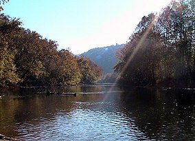
33:The Clinch River
31:
19:
2305:
2304:
2300:
2299:
2298:
2296:
2295:
2294:
2280:
2279:
2278:
2273:
2241:
2213:
2195:
2171:T. M. Gathright
2111:Mockhorn Island
2046:Game Farm Marsh
2011:Clinch Mountain
1967:
1960:
1896:Northwest River
1876:Mutton Hunk Fen
1856:Lyndhurst Ponds
1801:Difficult Creek
1771:Crawford's Knob
1766:Cowbane Prairie
1657:
1650:
1561:Conway Robinson
1507:
1498:Wilderness Road
1408:New River Trail
1278:Bear Creek Lake
1251:
1238:
1231:
1173:
1146:Other NPS Areas
1140:
1122:
1104:
1021:
1014:
982:National Trails
976:
931:
823:
795:
788:
739:Arlington House
725:
718:
691:
685:Protected areas
682:
630:
593:
591:Further reading
588:
587:
580:
569:Blue Ridge 2020
565:
564:
557:
550:
531:
530:
519:
509:
507:
494:
493:
489:
471:
470:
466:
459:
446:
445:
438:
433:
426:
416:
415:
411:
406:
374:
369:
312:
303:
261:
259:Natural history
244:
223:
156:
117:
115:
111:
108:
103:
100:
98:
96:
95:
86:
82:
78:
74:
63:
62:
61:
60:
57:
56:
55:
34:
17:
12:
11:
5:
2303:
2301:
2293:
2292:
2282:
2281:
2275:
2274:
2272:
2271:
2266:
2261:
2256:
2250:
2247:
2246:
2243:
2242:
2240:
2239:
2234:
2229:
2224:
2218:
2216:
2205:
2201:
2200:
2197:
2196:
2194:
2193:
2188:
2183:
2178:
2173:
2168:
2166:Stewarts Creek
2163:
2158:
2153:
2148:
2143:
2138:
2133:
2128:
2123:
2118:
2113:
2108:
2103:
2098:
2093:
2088:
2083:
2078:
2073:
2068:
2063:
2058:
2056:Hardware River
2053:
2048:
2043:
2038:
2033:
2028:
2023:
2018:
2013:
2008:
2003:
1998:
1993:
1988:
1983:
1978:
1972:
1970:
1962:
1961:
1959:
1958:
1953:
1948:
1943:
1938:
1933:
1928:
1923:
1918:
1913:
1908:
1903:
1898:
1893:
1888:
1883:
1881:Naked Mountain
1878:
1873:
1871:Mount Joy Pond
1868:
1863:
1858:
1853:
1851:Johnsons Creek
1848:
1846:Hughlett Point
1843:
1841:Hickory Hollow
1838:
1836:Grayson Glades
1833:
1828:
1823:
1818:
1813:
1808:
1803:
1798:
1793:
1791:Deep Run Ponds
1788:
1783:
1778:
1773:
1768:
1763:
1758:
1753:
1748:
1743:
1741:Chestnut Ridge
1738:
1733:
1728:
1723:
1718:
1713:
1708:
1703:
1698:
1693:
1688:
1683:
1681:Big Spring Bog
1678:
1673:
1668:
1662:
1660:
1652:
1651:
1649:
1648:
1643:
1638:
1633:
1628:
1623:
1618:
1613:
1608:
1603:
1598:
1593:
1588:
1586:First Mountain
1583:
1578:
1573:
1568:
1563:
1558:
1553:
1548:
1543:
1538:
1533:
1528:
1523:
1517:
1515:
1509:
1508:
1506:
1505:
1500:
1495:
1490:
1485:
1480:
1475:
1470:
1465:
1463:Staunton River
1460:
1455:
1450:
1445:
1440:
1435:
1430:
1425:
1420:
1415:
1410:
1405:
1403:Natural Tunnel
1400:
1398:Natural Bridge
1395:
1390:
1385:
1380:
1375:
1370:
1365:
1360:
1355:
1350:
1345:
1340:
1335:
1330:
1325:
1320:
1315:
1310:
1305:
1300:
1295:
1290:
1285:
1280:
1274:
1272:
1263:
1257:
1256:
1253:
1252:
1250:
1249:
1247:Chesapeake Bay
1243:
1241:
1233:
1232:
1230:
1229:
1224:
1219:
1217:Rough Mountain
1214:
1209:
1207:Ramsey's Draft
1204:
1199:
1194:
1189:
1187:Barbours Creek
1183:
1181:
1175:
1174:
1172:
1171:
1166:
1161:
1156:
1150:
1148:
1142:
1141:
1139:
1138:
1132:
1130:
1124:
1123:
1121:
1120:
1114:
1112:
1106:
1105:
1103:
1102:
1100:Wallops Island
1097:
1092:
1087:
1082:
1077:
1072:
1067:
1062:
1057:
1052:
1047:
1042:
1037:
1032:
1026:
1024:
1016:
1015:
1013:
1012:
1007:
1002:
997:
992:
986:
984:
978:
977:
975:
974:
969:
963:
961:Peaks of Otter
958:
953:
947:
941:
939:
933:
932:
930:
929:
924:
919:
914:
909:
904:
899:
894:
889:
884:
879:
877:Fredericksburg
874:
869:
864:
859:
854:
849:
844:
839:
833:
831:
825:
824:
822:
821:
816:
811:
806:
800:
798:
790:
789:
787:
786:
781:
776:
771:
769:Fort Monroe NM
766:
761:
756:
751:
746:
741:
736:
730:
728:
720:
719:
717:
716:
710:
708:
706:National Parks
699:
693:
692:
683:
681:
680:
673:
666:
658:
652:
651:
646:
641:
636:
629:
628:External links
626:
625:
624:
609:
592:
589:
586:
585:
578:
555:
548:
517:
487:
464:
458:978-1566951500
457:
436:
424:
408:
407:
405:
402:
401:
400:
395:
390:
389:
388:
383:
373:
370:
368:
367:
362:
357:
352:
347:
342:
337:
332:
327:
322:
316:
311:
310:Other clusters
308:
302:
299:
260:
257:
243:
240:
222:
219:
218:
217:
216:
215:
210:
205:
200:
198:Roaring Branch
195:
187:
186:
185:
180:
155:
152:
146:recognized by
134:
133:
130:
126:
125:
93:
89:
88:
69:
65:
64:
58:
49:
48:
42:
41:
40:
39:
36:
35:
32:
24:
23:
15:
13:
10:
9:
6:
4:
3:
2:
2302:
2291:
2288:
2287:
2285:
2270:
2267:
2265:
2262:
2260:
2257:
2255:
2252:
2251:
2248:
2238:
2235:
2233:
2230:
2228:
2225:
2223:
2220:
2219:
2217:
2215:
2209:
2206:
2202:
2192:
2189:
2187:
2184:
2182:
2179:
2177:
2174:
2172:
2169:
2167:
2164:
2162:
2159:
2157:
2154:
2152:
2149:
2147:
2144:
2142:
2139:
2137:
2136:Ragged Island
2134:
2132:
2131:Princess Anne
2129:
2127:
2124:
2122:
2119:
2117:
2116:Oakley Forest
2114:
2112:
2109:
2107:
2106:Merrimac Farm
2104:
2102:
2099:
2097:
2094:
2092:
2089:
2087:
2084:
2082:
2081:Horsepen Lake
2079:
2077:
2074:
2072:
2069:
2067:
2066:Hidden Valley
2064:
2062:
2059:
2057:
2054:
2052:
2049:
2047:
2044:
2042:
2039:
2037:
2034:
2032:
2029:
2027:
2024:
2022:
2019:
2017:
2016:Crooked Creek
2014:
2012:
2009:
2007:
2004:
2002:
1999:
1997:
1994:
1992:
1989:
1987:
1984:
1982:
1979:
1977:
1974:
1973:
1971:
1969:
1963:
1957:
1954:
1952:
1949:
1947:
1946:Unthanks Cave
1944:
1942:
1939:
1937:
1934:
1932:
1931:Poor Mountain
1929:
1927:
1924:
1922:
1919:
1917:
1914:
1912:
1909:
1907:
1906:Parkers Marsh
1904:
1902:
1899:
1897:
1894:
1892:
1889:
1887:
1884:
1882:
1879:
1877:
1874:
1872:
1869:
1867:
1864:
1862:
1859:
1857:
1854:
1852:
1849:
1847:
1844:
1842:
1839:
1837:
1834:
1832:
1829:
1827:
1826:Grafton Ponds
1824:
1822:
1819:
1817:
1814:
1812:
1809:
1807:
1804:
1802:
1799:
1797:
1796:Dendron Swamp
1794:
1792:
1789:
1787:
1786:Dameron Marsh
1784:
1782:
1779:
1777:
1774:
1772:
1769:
1767:
1764:
1762:
1761:Clover Hollow
1759:
1757:
1754:
1752:
1751:Chub Sandhill
1749:
1747:
1746:Chotank Creek
1744:
1742:
1739:
1737:
1734:
1732:
1729:
1727:
1724:
1722:
1719:
1717:
1714:
1712:
1709:
1707:
1704:
1702:
1699:
1697:
1694:
1692:
1689:
1687:
1684:
1682:
1679:
1677:
1674:
1672:
1669:
1667:
1666:Antioch Pines
1664:
1663:
1661:
1659:
1653:
1647:
1644:
1642:
1639:
1637:
1634:
1632:
1629:
1627:
1624:
1622:
1619:
1617:
1614:
1612:
1609:
1607:
1606:Moore's Creek
1604:
1602:
1599:
1597:
1594:
1592:
1589:
1587:
1584:
1582:
1579:
1577:
1574:
1572:
1569:
1567:
1564:
1562:
1559:
1557:
1556:Chilton Woods
1554:
1552:
1549:
1547:
1544:
1542:
1539:
1537:
1534:
1532:
1529:
1527:
1524:
1522:
1519:
1518:
1516:
1514:
1513:State forests
1510:
1504:
1501:
1499:
1496:
1494:
1491:
1489:
1486:
1484:
1481:
1479:
1478:Tabb Monument
1476:
1474:
1471:
1469:
1466:
1464:
1461:
1459:
1456:
1454:
1451:
1449:
1446:
1444:
1441:
1439:
1436:
1434:
1431:
1429:
1426:
1424:
1421:
1419:
1416:
1414:
1411:
1409:
1406:
1404:
1401:
1399:
1396:
1394:
1391:
1389:
1386:
1384:
1381:
1379:
1376:
1374:
1371:
1369:
1366:
1364:
1361:
1359:
1356:
1354:
1353:Hungry Mother
1351:
1349:
1348:Holliday Lake
1346:
1344:
1341:
1339:
1336:
1334:
1333:First Landing
1331:
1329:
1326:
1324:
1321:
1319:
1316:
1314:
1311:
1309:
1306:
1304:
1301:
1299:
1296:
1294:
1291:
1289:
1286:
1284:
1281:
1279:
1276:
1275:
1273:
1271:
1267:
1264:
1262:
1258:
1248:
1245:
1244:
1242:
1240:
1234:
1228:
1225:
1223:
1220:
1218:
1215:
1213:
1210:
1208:
1205:
1203:
1200:
1198:
1197:Mountain Lake
1195:
1193:
1190:
1188:
1185:
1184:
1182:
1180:
1176:
1170:
1167:
1165:
1162:
1160:
1157:
1155:
1152:
1151:
1149:
1147:
1143:
1137:
1134:
1133:
1131:
1129:
1125:
1119:
1116:
1115:
1113:
1111:
1107:
1101:
1098:
1096:
1093:
1091:
1088:
1086:
1083:
1081:
1078:
1076:
1073:
1071:
1068:
1066:
1063:
1061:
1058:
1056:
1053:
1051:
1048:
1046:
1043:
1041:
1038:
1036:
1033:
1031:
1028:
1027:
1025:
1023:
1017:
1011:
1008:
1006:
1003:
1001:
998:
996:
993:
991:
988:
987:
985:
983:
979:
973:
970:
967:
964:
962:
959:
957:
954:
952:
948:
946:
943:
942:
940:
938:
934:
928:
925:
923:
920:
918:
915:
913:
910:
908:
905:
903:
900:
898:
895:
893:
890:
888:
885:
883:
880:
878:
875:
873:
872:Fort Harrison
870:
868:
865:
863:
860:
858:
855:
853:
850:
848:
845:
843:
840:
838:
835:
834:
832:
830:
826:
820:
817:
815:
814:Petersburg NB
812:
810:
807:
805:
802:
801:
799:
797:
791:
785:
782:
780:
777:
775:
772:
770:
767:
765:
762:
760:
757:
755:
752:
750:
747:
745:
742:
740:
737:
735:
732:
731:
729:
727:
721:
715:
712:
711:
709:
707:
703:
700:
698:
694:
690:
686:
679:
674:
672:
667:
665:
660:
659:
656:
650:
647:
645:
642:
640:
637:
635:
632:
631:
627:
622:
621:0-8203-2125-7
618:
614:
610:
607:
603:
599:
595:
594:
590:
581:
579:0-8078-4759-3
575:
571:
570:
562:
560:
556:
551:
549:1-56352-462-7
545:
541:
537:
536:
528:
526:
524:
522:
518:
505:
501:
497:
491:
488:
483:
478:
477:
468:
465:
460:
454:
450:
443:
441:
437:
431:
429:
425:
420:
413:
410:
403:
399:
396:
394:
391:
387:
384:
382:
379:
378:
376:
375:
371:
366:
363:
361:
358:
356:
353:
351:
348:
346:
343:
341:
338:
336:
333:
331:
328:
326:
323:
321:
318:
317:
315:
309:
307:
300:
298:
294:
290:
288:
282:
280:
276:
265:
258:
256:
252:
250:
241:
239:
237:
227:
220:
214:
211:
209:
206:
204:
201:
199:
196:
194:
191:
190:
188:
184:
181:
179:
176:
175:
173:
172:
171:
169:
165:
161:
153:
151:
149:
145:
141:
131:
129:Administrator
127:
122:
94:
90:
85:
81:
77:
73:
70:
46:
37:
30:
25:
20:
2006:Chickahominy
1991:Briery Creek
1956:Wreck Island
1726:The Channels
1676:Bethel Beach
1656:Natural Area
1551:Chesterfield
1488:Westmoreland
1308:Clinch River
1303:Claytor Lake
1227:Three Ridges
1222:Saint Mary's
1080:Occoquan Bay
1060:Glenn Martin
1050:Featherstone
1035:Chincoteague
897:Poplar Grove
892:Hampton VAMC
819:Richmond NBP
809:Manassas NBP
759:Colonial NHP
612:
597:
568:
534:
508:. Retrieved
499:
490:
475:
467:
448:
418:
412:
313:
304:
295:
291:
283:
279:edge effects
271:
253:
249:Russell Fork
245:
235:
232:
157:
139:
137:
72:Scott County
2156:Short Hills
2086:James River
1901:Ogdens Cave
1861:Magothy Bay
1831:Grassy Hill
1821:Goshen Pass
1776:Crow's Nest
1631:Sandy Point
1611:Niday Place
1448:Sky Meadows
1433:Seven Bends
1413:Occoneechee
1378:Machicomoco
1373:Leesylvania
1358:James River
1323:Fairy Stone
1270:State parks
1070:James River
912:Seven Pines
857:Cold Harbor
847:Balls Bluff
154:Description
116: /
92:Coordinates
80:Wise County
2181:Ware Creek
2176:Turkeycock
2091:Land's End
2076:Hog Island
2036:Featherfin
2021:Dick Cross
1981:Big Survey
1811:False Cape
1721:The Cedars
1686:Blackwater
1636:South Quay
1581:Dragon Run
1571:Cumberland
1503:York River
1483:Twin Lakes
1438:Shot Tower
1418:Pocahontas
1388:Mayo River
1383:Mason Neck
1328:False Cape
1283:Belle Isle
1045:Mason Neck
956:Mabry Mill
922:Winchester
852:City Point
837:Alexandria
714:Shenandoah
510:4 February
404:References
104:82°35′51″W
2121:Pettigrew
2096:Mattaponi
2026:Doe Creek
1986:Big Woods
1716:Cave Hill
1671:Bald Knob
1658:Preserves
1566:Crawfords
1546:Charlotte
1526:Big Woods
1493:Widewater
1473:Sweet Run
1368:Lake Anna
1363:Kiptopeke
1298:Chippokes
1212:Rich Hole
1090:Presquile
1075:Nansemond
842:Arlington
101:37°7′29″N
2284:Category
2126:Powhatan
2071:Highland
2001:Cavalier
1966:Wildlife
1926:Pinnacle
1616:Old Flat
1601:Matthews
1541:Channels
1531:Bourassa
1423:Powhatan
1030:Back Bay
1020:National
927:Yorktown
917:Staunton
907:Richmond
902:Quantico
882:Glendale
867:Danville
862:Culpeper
689:Virginia
504:Archived
372:See also
275:foraging
68:Location
2232:Bridges
2141:Rapidan
1641:Whitney
1596:Lesesne
1318:Douthat
1293:Caledon
887:Hampton
697:Federal
2186:Weston
2061:Havens
1976:Amelia
1536:Browne
1202:Priest
619:
604:
576:
546:
455:
2204:Other
2151:Saxis
1591:Hawks
1261:State
540:21–24
1646:Zoar
1621:Paul
617:ISBN
602:ISBN
574:ISBN
544:ISBN
512:2019
453:ISBN
138:The
687:of
482:111
2286::
558:^
542:.
520:^
502:.
498:.
439:^
427:^
238:.
170::
968:)
949:(
677:e
670:t
663:v
623:.
608:.
582:.
552:.
514:.
484:.
461:.
Text is available under the Creative Commons Attribution-ShareAlike License. Additional terms may apply.