29:
324:
280:
334:
256:
178:
329:
319:
195:
190:
150:
142:
219:
200:
162:
158:
34:
28:
166:
134:
170:
146:
138:
252:
154:
313:
130:
50:
231:
U.S. Geological Survey. National
Hydrography Dataset high-resolution flowline data.
118:
90:
295:
282:
251:(4th ed.). Richmond, VA: Virginia Office of Graphic Communications.
232:
174:
126:
122:
105:
79:
220:
U.S. Geological Survey
Geographic Names Information System: Russell Fork
272:
173:
where it flows into the Levisa Fork which, together with the
247:
Salmon, Emily J.; Edward D. C. Campbell, Jr., eds. (1994).
153:. The Russell Fork continues to flow through the town of
117:
is a 51.9-mile-long (83.5 km) tributary of the
243:
USGS Hydrologic Unit Map - State of
Virginia (1974)
99:
89:
73:
65:
56:
46:
41:
21:
133:. Known for its whitewater, it rises in the
8:
222:, 1975 Board on Geographic Names decision
325:Landforms of Dickenson County, Virginia
212:
18:
7:
14:
249:The Hornbook of Virginia History
27:
335:Rivers of Pike County, Kentucky
1:
57:Physical characteristics
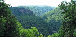
33:Russell Fork flowing through
149:, and flows northwest into
101: • location
75: • location
351:
196:List of rivers of Virginia
191:List of rivers of Kentucky
16:River in the United States
85:
61:
26:
235:, accessed June 13, 2011
201:Breaks Interstate Park
169:, to the community of
163:Elkhorn City, Kentucky
159:Breaks Interstate Park
35:Breaks Interstate Park
296:37.40677°N 82.44015°W
135:Appalachian Mountains
301:37.40677; -82.44015
292: /
330:Rivers of Kentucky
320:Rivers of Virginia
161:, and the town of
139:southwest Virginia
273:Russell Fork Info
171:Millard, Kentucky
125:and southeastern
111:
110:
342:
307:
306:
304:
303:
302:
297:
293:
290:
289:
288:
285:
262:
236:
233:The National Map
229:
223:
217:
151:Dickenson County
121:in southwestern
76:
31:
19:
350:
349:
345:
344:
343:
341:
340:
339:
310:
309:
300:
298:
294:
291:
286:
283:
281:
279:
278:
269:
259:
246:
240:
239:
230:
226:
218:
214:
209:
187:
179:Big Sandy River
155:Haysi, Virginia
145:at the base of
143:Buchanan County
102:
74:
37:
17:
12:
11:
5:
348:
346:
338:
337:
332:
327:
322:
312:
311:
276:
275:
268:
267:External links
265:
264:
263:
257:
244:
238:
237:
224:
211:
210:
208:
205:
204:
203:
198:
193:
186:
183:
147:Big A Mountain
141:, in southern
109:
108:
103:
100:
97:
96:
93:
87:
86:
83:
82:
77:
71:
70:
67:
63:
62:
59:
58:
54:
53:
48:
44:
43:
39:
38:
32:
24:
23:
15:
13:
10:
9:
6:
4:
3:
2:
347:
336:
333:
331:
328:
326:
323:
321:
318:
317:
315:
308:
305:
274:
271:
270:
266:
260:
258:0-88490-177-7
254:
250:
245:
242:
241:
234:
228:
225:
221:
216:
213:
206:
202:
199:
197:
194:
192:
189:
188:
184:
182:
180:
176:
172:
168:
164:
160:
156:
152:
148:
144:
140:
136:
132:
131:United States
128:
124:
120:
116:
107:
104:
98:
94:
92:
88:
84:
81:
78:
72:
68:
64:
60:
55:
52:
51:United States
49:
45:
40:
36:
30:
25:
20:
277:
248:
227:
215:
115:Russell Fork
114:
112:
22:Russell Fork
299: /
177:, form the
167:Pike County
119:Levisa Fork
314:Categories
287:82°26′25″W
284:37°24′24″N
207:References
185:See also
175:Tug Fork
127:Kentucky
123:Virginia
106:Kentucky
80:Virginia
42:Location
129:in the
47:Country
255:
157:, the
95:
69:
66:Source
165:, in
91:Mouth
253:ISBN
113:The
137:of
316::
181:.
261:.
Text is available under the Creative Commons Attribution-ShareAlike License. Additional terms may apply.