31:
289:
In warm months, there is a great shortage of water. Even the largest river in this area, the
Kogylnik, then dries, and it is often due to lack of water that the livestock of the Tatars die from thirst. In the autumn, when the rainy season starts, there appear suddenly appear countless streams across
290:
the low country. All of the marshes are then covered with puddles. To overcome the water shortages suffered in the summer, one finds very deep wells have been dug everywhere. Among the Tatars, as in the east, digging wells has become an act of religion and honor.
30:
456:
410:
485:
126:
490:
368:
201:
0.30 m/s (11 cu ft/s) (avg), 6.47 m/s (228 cu ft/s) (max), .0006 m/s (0.021 cu ft/s) (min)
500:
449:
403:
475:
308:
505:
495:
442:
396:
36:
480:
333:
282:
227:
86:
364:
426:
380:
239:
235:
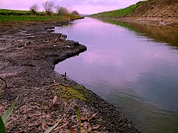
469:
312:
263:
259:
247:
112:
267:
243:
97:
215:(also Cogîlnic, Kogylnik, Kogîlnic, Kohylnyk, or Kunduk) is a 243 km river in
141:
128:
271:
309:"The Characteristics of principal water courses in the Republic of Moldova"
220:
216:
57:
53:
255:
251:
344:
359:
Brezianu, Andrei and Spânu, Vlad (eds.) (2007) "Cogâlnic/Kogâlnic"
231:
363:(2nd ed.) Scarecrow Press, Lanham, Maryland, USA, p. 92,
343:) published in Russian in 1991 by Tavria, in Simferopol,
430:
384:
195:
187:
175:
167:
157:
118:
106:
96:
80:
72:
63:
49:
44:
23:
425:This article related to a river in Ukraine is a
379:This article related to a river in Moldova is a
450:
404:
285:in his eighteenth century work described it:
8:
457:
443:
411:
397:
258:and into the Prichernomorskoy lowlands of
262:(province) of Ukraine. Together with the
300:
20:
179:3,910 km (1,510 sq mi)
7:
422:
420:
376:
374:
226:The Cogâlnic rises in the hills of
429:. You can help Knowledge (XXG) by
383:. You can help Knowledge (XXG) by
14:
238:. It flows through the cities of
361:Historical Dictionary of Moldova
29:
486:International rivers of Europe
234:west of the Moldovan capital,
120: • coordinates
1:
64:Physical characteristics
491:Tributaries of the Black Sea
159: • elevation
108: • location
82: • location
37:Bilhorod-Dnistrovskyi Raion
522:
419:
373:
197: • average
205:
183:
171:243 km (151 mi)
92:
68:
28:
18:River in Moldova, Ukraine
501:Moldova geography stubs
476:Rivers of Odesa Oblast
283:Johann Erich Thunmann
270:and thence into the
250:, and then into the
163:0 m (0 ft)
506:Ukraine river stubs
142:45.8019°N 29.6700°E
138: /
496:Europe river stubs
228:Nisporeni District
219:and south-western
87:Nisporeni District
481:Rivers of Moldova
438:
437:
392:
391:
369:978-0-8108-5607-3
337:Krymskoe Khanstvo
209:
208:
513:
459:
452:
445:
421:
413:
406:
399:
375:
347:
334:Thunmann, Johann
331:
325:
324:
322:
320:
311:. Archived from
305:
198:
153:
152:
150:
149:
148:
147:45.8019; 29.6700
143:
139:
136:
135:
134:
131:
83:
33:
21:
521:
520:
516:
515:
514:
512:
511:
510:
466:
465:
464:
463:
418:
417:
356:
351:
350:
341:Crimean Khanate
332:
328:
318:
316:
307:
306:
302:
297:
280:
196:
160:
146:
144:
140:
137:
132:
129:
127:
125:
124:
121:
109:
81:
40:
19:
12:
11:
5:
519:
517:
509:
508:
503:
498:
493:
488:
483:
478:
468:
467:
462:
461:
454:
447:
439:
436:
435:
416:
415:
408:
401:
393:
390:
389:
372:
371:
355:
352:
349:
348:
326:
315:on 12 May 2018
299:
298:
296:
293:
292:
291:
279:
276:
266:it enters the
207:
206:
203:
202:
199:
193:
192:
189:
185:
184:
181:
180:
177:
173:
172:
169:
165:
164:
161:
158:
155:
154:
122:
119:
116:
115:
110:
107:
104:
103:
100:
94:
93:
90:
89:
84:
78:
77:
74:
70:
69:
66:
65:
61:
60:
51:
47:
46:
42:
41:
39:, Odesa Oblast
34:
26:
25:
17:
13:
10:
9:
6:
4:
3:
2:
518:
507:
504:
502:
499:
497:
494:
492:
489:
487:
484:
482:
479:
477:
474:
473:
471:
460:
455:
453:
448:
446:
441:
440:
434:
432:
428:
423:
414:
409:
407:
402:
400:
395:
394:
388:
386:
382:
377:
370:
366:
362:
358:
357:
353:
346:
345:OCLC 28138870
342:
338:
335:
330:
327:
314:
310:
304:
301:
294:
288:
287:
286:
284:
277:
275:
273:
269:
265:
261:
257:
253:
249:
245:
241:
237:
233:
229:
224:
222:
218:
214:
204:
200:
194:
190:
186:
182:
178:
174:
170:
166:
162:
156:
151:
123:
117:
114:
111:
105:
101:
99:
95:
91:
88:
85:
79:
75:
71:
67:
62:
59:
55:
52:
48:
43:
38:
35:The river in
32:
27:
22:
16:
431:expanding it
424:
385:expanding it
378:
360:
340:
336:
329:
317:. Retrieved
313:the original
303:
281:
264:Sarata River
260:Odesa Oblast
248:Basarabeasca
232:Codri region
225:
212:
210:
113:Sasyk Lagoon
15:
268:Sasyk Liman
145: /
470:Categories
354:References
176:Basin size
133:29°40′12″E
130:45°48′07″N
272:Black Sea
188:Discharge
244:Cimișlia
240:Hîncești
236:Chișinău
213:Cogâlnic
45:Location
24:Cogâlnic
278:History
254:, past
230:in the
221:Ukraine
217:Moldova
58:Ukraine
54:Moldova
50:Country
367:
319:20 May
256:Artsyz
252:Budjak
191:
168:Length
102:
76:
73:Source
295:Notes
98:Mouth
427:stub
381:stub
365:ISBN
321:2017
246:and
211:The
472::
274:.
242:,
223:.
56:,
458:e
451:t
444:v
433:.
412:e
405:t
398:v
387:.
339:(
323:.
Text is available under the Creative Commons Attribution-ShareAlike License. Additional terms may apply.