42:
506:
281:
57:
295:
269:
produced by that species. The mussels were systematically harvested for only a short time because they soon realized that the yield of pearls was too low for their harvest to be economically viable.
1215:
1205:
1190:
1185:
1195:
494:
1210:
1180:
423:
1200:
673:
1058:
16:
This article is about the river in Texas, a tributary of the
Colorado River. For the river in Mexico, tributary of the Rio Grande, see
257:
in 1650 led by
Captain Diego del Castillo, to explore what is now north central Texas. The expedition reached the territory of the
748:
1031:
472:
262:
250:
124:
791:
384:
246:
265:
was launched in 1654 to follow up on
Castillo's findings. The Spanish explored the river for the gem-quality purple to pink
781:
487:
693:
597:
886:
743:
708:
41:
226:. The combined branches of the river flow east about 58 mi (93 km) until it eventually empties into the
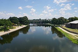
1151:
1085:
1080:
733:
219:
1175:
480:
342:
954:
906:
308:
95:
1036:
939:
786:
758:
728:
718:
703:
227:
1105:
896:
891:
821:
688:
567:
552:
218:
and traveling southeast for 88 mi (142 km) until merging with the South and Middle forks near
431:
1046:
979:
919:
723:
713:
313:
254:
215:
91:
1115:
959:
831:
776:
652:
582:
577:
562:
542:
211:
207:
1131:
1075:
1063:
856:
766:
647:
637:
460:
380:
362:
235:
223:
47:
1090:
1026:
841:
836:
657:
572:
300:
184:
396:
1141:
881:
851:
642:
632:
455:
357:
1095:
964:
949:
914:
801:
678:
547:
523:
231:
1169:
1110:
1100:
989:
934:
866:
861:
816:
607:
592:
587:
318:
1146:
1068:
1016:
1004:
994:
969:
929:
924:
683:
467:
286:
1051:
1021:
999:
984:
876:
871:
826:
811:
738:
698:
627:
622:
537:
107:
17:
56:
1041:
1009:
974:
806:
771:
612:
602:
557:
532:
276:
193:
172:
139:
126:
1136:
796:
846:
214:
Concho Rivers. The North Concho River is the longest fork, starting in
343:
U.S. Geological Survey
Geographic Names Information System: Concho River
617:
258:
187:
for "shell"; the river was so named due to its abundance of freshwater
188:
511:
505:
266:
176:
476:
261:
Indians, and reported finding pearls on the Concho River. The
1124:
905:
757:
666:
518:
155:
116:
106:
101:
87:
79:
71:
66:
28:
61:Map of the Concho River and associated watershed
206:The Concho River has three primary feeds: the
488:
8:
495:
481:
473:
430:. Conchologists of America. Archived from
1216:Tributaries of the Colorado River (Texas)
468:Southwest Paddler report on Concho River
330:
338:
336:
334:
234:about 12 mi (19 km) east of
25:
352:
350:
191:, such as the Tampico pearly mussel (
7:
403:. Texas State Historical Association
1206:Rivers of Schleicher County, Texas
14:
1191:Rivers of Glasscock County, Texas
1186:Rivers of Tom Green County, Texas
1196:Rivers of Sterling County, Texas
504:
293:
279:
253:, dispatched an expedition from
55:
40:
1032:Prairie Dog Town Fork Red River
263:Diego de Guadalajara expedition
1211:Rivers of Concho County, Texas
1181:Rivers of Howard County, Texas
792:Falcon International Reservoir
379:DeLorme, 4th ed., 2001, p. 55
247:Hernando de Ugarte y la Concha
118: • coordinates
1:
356: Julia Cauble Smith:
102:Physical characteristics
23:River in Texas, United States
1201:Rivers of Coke County, Texas
367:. Retrieved 2010-05-18.
157: • elevation
887:Richland-Chambers Reservoir
424:"The Tampico Pearlymussel (
422:Howells, Robert G. (1996).
377:Texas Atlas & Gazeteer,
161:1,480 ft (450 m)
1232:
709:Gulf Intracoastal Waterway
15:
428:) Shades of the Old West"
230:within the waters of the
220:Goodfellow Air Force Base
54:
39:
401:Handbook of Texas Online
674:Acequia Madre de Valero
426:Cyrtonaias tampicoensis
309:List of rivers of Texas
787:Choke Canyon Reservoir
744:Sabine–Neches Waterway
729:Port Mansfield Channel
719:Matagorda Ship Channel
251:Governor of New Mexico
897:Toledo Bend Reservoir
892:Sam Rayburn Reservoir
782:Cedar Creek Reservoir
397:"Castillo, Diego Del"
140:31.57139°N 99.72472°W
759:Lakes and reservoirs
714:Houston Ship Channel
694:Brazos Santiago Pass
314:Concho County, Texas
46:The Concho River in
832:Lake Corpus Christi
667:Channels and canals
145:31.57139; -99.72472
136: /
583:Espiritu Santo Bay
578:East Matagorda Bay
563:Corpus Christi Bay
519:Bays and estuaries
456:North Concho River
171:is a river in the
1160:
1159:
1152:Rio Grande Valley
1132:Big Cypress Bayou
1086:San Jacinto River
1081:San Gabriel River
1076:San Bernard River
1064:San Antonio River
857:Lake Marble Falls
767:Amistad Reservoir
648:Tres Palacios Bay
526:
461:Handbook of Texas
363:Handbook of Texas
236:Paint Rock, Texas
224:San Angelo, Texas
165:
164:
48:San Angelo, Texas
1223:
1091:San Marcos River
1027:Pedernales River
842:Lake Ray Roberts
837:Lake Ray Hubbard
521:
509:
508:
497:
490:
483:
474:
443:
442:
440:
439:
419:
413:
412:
410:
408:
393:
387:
374:
368:
354:
345:
340:
303:
301:Geography portal
298:
297:
296:
289:
284:
283:
282:
151:
150:
148:
147:
146:
141:
137:
134:
133:
132:
129:
59:
44:
26:
1231:
1230:
1226:
1225:
1224:
1222:
1221:
1220:
1176:Rivers of Texas
1166:
1165:
1163:
1161:
1156:
1142:Ottine wetlands
1120:
955:Guadalupe River
901:
882:Lewisville Lake
852:Lake Livingston
753:
734:Riverside Canal
662:
643:St. Charles Bay
633:San Antonio Bay
520:
514:
503:
501:
452:
447:
446:
437:
435:
421:
420:
416:
406:
404:
395:
394:
390:
375:
371:
355:
348:
341:
332:
327:
299:
294:
292:
285:
280:
278:
275:
244:
204:
158:
144:
142:
138:
135:
130:
127:
125:
123:
122:
119:
62:
50:
35:
30:
24:
21:
12:
11:
5:
1229:
1227:
1219:
1218:
1213:
1208:
1203:
1198:
1193:
1188:
1183:
1178:
1168:
1167:
1158:
1157:
1155:
1154:
1149:
1144:
1139:
1134:
1128:
1126:
1122:
1121:
1119:
1118:
1113:
1108:
1103:
1098:
1096:San Saba River
1093:
1088:
1083:
1078:
1073:
1072:
1071:
1061:
1056:
1055:
1054:
1049:
1039:
1034:
1029:
1024:
1019:
1014:
1013:
1012:
1002:
997:
992:
987:
982:
977:
972:
967:
965:Lampasas River
962:
957:
952:
950:Canadian River
947:
942:
940:Colorado River
937:
932:
927:
922:
917:
915:Angelina River
911:
909:
903:
902:
900:
899:
894:
889:
884:
879:
874:
869:
864:
859:
854:
849:
844:
839:
834:
829:
824:
819:
814:
809:
804:
802:Lady Bird Lake
799:
794:
789:
784:
779:
774:
769:
763:
761:
755:
754:
752:
751:
746:
741:
736:
731:
726:
721:
716:
711:
706:
704:Franklin Canal
701:
696:
691:
686:
681:
679:American Canal
676:
670:
668:
664:
663:
661:
660:
655:
650:
645:
640:
635:
630:
625:
620:
615:
610:
605:
600:
595:
590:
585:
580:
575:
570:
565:
560:
555:
550:
548:Carancahua Bay
545:
540:
535:
529:
527:
524:Gulf of Mexico
516:
515:
502:
500:
499:
492:
485:
477:
471:
470:
465:
451:
450:External links
448:
445:
444:
414:
388:
369:
346:
329:
328:
326:
323:
322:
321:
316:
311:
305:
304:
290:
274:
271:
243:
240:
232:O.H. Ivie Lake
228:Colorado River
210:, Middle, and
203:
200:
163:
162:
159:
156:
153:
152:
120:
117:
114:
113:
110:
104:
103:
99:
98:
89:
85:
84:
81:
77:
76:
73:
69:
68:
64:
63:
60:
52:
51:
45:
37:
36:
31:
22:
13:
10:
9:
6:
4:
3:
2:
1228:
1217:
1214:
1212:
1209:
1207:
1204:
1202:
1199:
1197:
1194:
1192:
1189:
1187:
1184:
1182:
1179:
1177:
1174:
1173:
1171:
1164:
1153:
1150:
1148:
1145:
1143:
1140:
1138:
1135:
1133:
1130:
1129:
1127:
1123:
1117:
1114:
1112:
1111:Wichita River
1109:
1107:
1106:Trinity River
1104:
1102:
1101:Sulphur River
1099:
1097:
1094:
1092:
1089:
1087:
1084:
1082:
1079:
1077:
1074:
1070:
1067:
1066:
1065:
1062:
1060:
1057:
1053:
1050:
1048:
1045:
1044:
1043:
1040:
1038:
1035:
1033:
1030:
1028:
1025:
1023:
1020:
1018:
1015:
1011:
1008:
1007:
1006:
1003:
1001:
998:
996:
993:
991:
990:Navidad River
988:
986:
983:
981:
978:
976:
973:
971:
968:
966:
963:
961:
958:
956:
953:
951:
948:
946:
943:
941:
938:
936:
935:Buffalo Bayou
933:
931:
928:
926:
923:
921:
918:
916:
913:
912:
910:
908:
904:
898:
895:
893:
890:
888:
885:
883:
880:
878:
875:
873:
870:
868:
867:Lake Tawakoni
865:
863:
862:Lake Meredith
860:
858:
855:
853:
850:
848:
845:
843:
840:
838:
835:
833:
830:
828:
825:
823:
822:Lake Buchanan
820:
818:
817:Lake Bardwell
815:
813:
810:
808:
805:
803:
800:
798:
795:
793:
790:
788:
785:
783:
780:
778:
775:
773:
770:
768:
765:
764:
762:
760:
756:
750:
749:San Luis Pass
747:
745:
742:
740:
737:
735:
732:
730:
727:
725:
722:
720:
717:
715:
712:
710:
707:
705:
702:
700:
697:
695:
692:
690:
689:Bolivar Roads
687:
685:
682:
680:
677:
675:
672:
671:
669:
665:
659:
656:
654:
651:
649:
646:
644:
641:
639:
636:
634:
631:
629:
626:
624:
621:
619:
616:
614:
611:
609:
608:Matagorda Bay
606:
604:
601:
599:
596:
594:
593:Guadalupe Bay
591:
589:
588:Galveston Bay
586:
584:
581:
579:
576:
574:
571:
569:
568:Dickinson Bay
566:
564:
561:
559:
556:
554:
553:Christmas Bay
551:
549:
546:
544:
541:
539:
536:
534:
531:
530:
528:
525:
517:
513:
507:
498:
493:
491:
486:
484:
479:
478:
475:
469:
466:
464:
462:
457:
454:
453:
449:
434:on 2012-03-06
433:
429:
427:
418:
415:
402:
398:
392:
389:
386:
382:
378:
373:
370:
366:
364:
359:
353:
351:
347:
344:
339:
337:
335:
331:
324:
320:
319:Concho Valley
317:
315:
312:
310:
307:
306:
302:
291:
288:
277:
272:
270:
268:
264:
260:
256:
252:
248:
241:
239:
237:
233:
229:
225:
221:
217:
216:Howard County
213:
209:
201:
199:
197:
195:
190:
186:
182:
178:
174:
170:
160:
154:
149:
121:
115:
111:
109:
105:
100:
97:
93:
90:
86:
82:
78:
75:United States
74:
70:
65:
58:
53:
49:
43:
38:
34:
27:
19:
1162:
1147:Rincon Bayou
1069:Medina River
1059:Sabine River
1047:Devils River
1017:Paluxy River
1005:Nueces River
995:Neches River
980:Little River
970:Lavaca River
945:Concho River
944:
930:Brazos River
925:Bosque River
920:Blanco River
724:Pass Cavallo
684:Aransas Pass
598:Laguna Madre
459:
436:. Retrieved
432:the original
425:
417:
405:. Retrieved
400:
391:
376:
372:
361:
358:Concho River
287:Texas portal
245:
205:
196:tampicoensis
192:
180:
169:Concho River
168:
166:
32:
29:Concho River
1116:White River
1052:Pecos River
1022:Pease River
1000:Nolan River
985:Llano River
960:James River
877:Lake Travis
872:Lake Texoma
827:Lake Conroe
812:Lake Austin
777:Canyon Lake
739:Sabine Pass
699:Cedar Bayou
653:Trinity Bay
628:Sabine Lake
623:Redfish Bay
538:Aransas Bay
143: /
18:Rio Conchos
1170:Categories
1042:Rio Grande
1010:Frio River
975:Leon River
807:Lavon Lake
772:Caddo Lake
613:Nueces Bay
603:Lavaca Bay
558:Copano Bay
543:Baffin Bay
533:Alazan Bay
510:Waters of
438:2010-05-18
385:0899333206
325:References
194:Cyrtonaias
173:U.S. state
131:99°43′29″W
128:31°34′17″N
33:Río Concho
1137:Cow Bayou
1037:Red River
797:Inks Lake
638:South Bay
458:from the
360:from the
202:Geography
96:Tom Green
1125:Wetlands
847:Lake LBJ
658:West Bay
573:East Bay
407:July 21,
273:See also
255:Santa Fe
88:Counties
67:Location
618:Oso Bay
522:of the
242:History
189:mussels
185:Spanish
72:Country
907:Rivers
463:Online
383:
365:Online
267:pearls
181:Concho
112:
92:Concho
512:Texas
259:Tejas
212:South
208:North
177:Texas
108:Mouth
83:Texas
80:State
409:2012
381:ISBN
179:.
167:The
94:and
222:in
198:).
183:is
175:of
1172::
399:.
349:^
333:^
249:,
238:.
496:e
489:t
482:v
441:.
411:.
20:.
Text is available under the Creative Commons Attribution-ShareAlike License. Additional terms may apply.