272:
41:
145:
veins and the town of Copala was founded to serve the mines. The town was named after a mythical city of gold for which de Ibarra had unsuccessfully searched in northern Mexico.
320:
344:
339:
282:
122:
171:
313:
200:
306:
76:
130:
40:
126:
110:
256:
134:
61:
260:
290:
271:
333:
102:
204:
186:
173:
152:
Indians, but was rebuilt after the rebellion was quelled the following year.
149:
286:
106:
66:
279:
142:
54:
160:
The economy of Copala is based on tourism, mining, and agriculture.
138:
240:, Seville: Escuela de Estudios Hispano-Americanos, p.14-17.
148:
The town of Copala was destroyed in 1616 by an uprising of
294:
253:
82:
72:
60:
50:
24:
227:, Culiacán: Universidad Autónoma de Sinaloa, p.24.
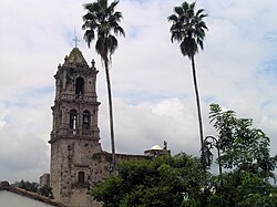
101:, is a four-century-old silver-mining town in the
199:, at an altitude of 610 m. The town is along
314:
8:
321:
307:
21:
225:Economía y Sociedad en Sinaloa, 1591-1900
216:
121:The area was occupied and ruled by the
81:
49:
37:
109:. The town is in the municipality of
278:This article about a location in the
71:
59:
7:
268:
266:
141:. In 1565 prospectors discovered
14:
238:Sonora y Sinaloa en el Siglo XVII
270:
39:
345:Northern Mexico geography stubs
203:, approximately 50 km east of
1:
16:Silver-mining town in Sinaloa
293:. You can help Knowledge by
340:Populated places in Sinaloa
236:Luis Navarro Garcia (1967)
223:Benito Ramírez Meza (1993)
137:and conquered the area for
361:
265:
125:peoples until 1564, when
38:
31:
254:Copala official website
131:Sierra Madre Occidental
19:Town in Sinaloa, Mexico
187:23.39472°N 105.93250°W
168:Copala is located at
192:23.39472; -105.93250
97:, formerly known as
183: /
127:Francisco de Ibarra
259:2013-05-30 at the
201:Federal Highway 40
99:San José de Copala
45:San José de Copala
302:
301:
92:
91:
352:
323:
316:
309:
274:
267:
241:
234:
228:
221:
198:
197:
195:
194:
193:
188:
184:
181:
180:
179:
176:
43:
22:
360:
359:
355:
354:
353:
351:
350:
349:
330:
329:
328:
327:
261:Wayback Machine
250:
245:
244:
235:
231:
222:
218:
213:
191:
189:
185:
182:
177:
174:
172:
170:
169:
166:
158:
119:
88:
46:
34:
27:
20:
17:
12:
11:
5:
358:
356:
348:
347:
342:
332:
331:
326:
325:
318:
311:
303:
300:
299:
275:
264:
263:
249:
248:External links
246:
243:
242:
229:
215:
214:
212:
209:
165:
162:
157:
154:
118:
115:
90:
89:
86:
84:
80:
79:
74:
70:
69:
64:
58:
57:
52:
48:
47:
44:
36:
35:
32:
29:
28:
25:
18:
15:
13:
10:
9:
6:
4:
3:
2:
357:
346:
343:
341:
338:
337:
335:
324:
319:
317:
312:
310:
305:
304:
298:
296:
292:
288:
284:
281:
276:
273:
269:
262:
258:
255:
252:
251:
247:
239:
233:
230:
226:
220:
217:
210:
208:
206:
202:
196:
163:
161:
155:
153:
151:
146:
144:
140:
136:
132:
128:
124:
116:
114:
112:
108:
104:
103:Mexican state
100:
96:
85:
78:
75:
68:
65:
63:
56:
53:
42:
30:
23:
295:expanding it
277:
237:
232:
224:
219:
167:
159:
147:
129:crossed the
120:
98:
94:
93:
73:Municipality
190: /
178:105°55′57″W
83:Postal code
334:Categories
211:References
175:23°23′41″N
123:indigenous
26:El Quelite
164:Geography
111:Concordia
77:Concordia
257:Archived
205:Mazatlán
150:Tepehuan
287:Sinaloa
280:Mexican
156:Economy
135:Durango
117:History
107:Sinaloa
67:Sinaloa
51:Country
143:silver
95:Copala
55:Mexico
289:is a
283:state
139:Spain
133:from
87:82650
62:State
291:stub
33:Town
285:of
105:of
336::
207:.
113:.
322:e
315:t
308:v
297:.
Text is available under the Creative Commons Attribution-ShareAlike License. Additional terms may apply.