30:
22:
143:
53:
150:
The
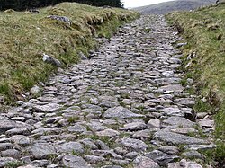
Highland Council states that the Corrieyairack Pass is not maintained as a public road, and is not suitable for use as one, so it advises against using motor vehicles on the pass. The road surface is made of stone, though it is now very eroded and damaged, and in many places the original paving
133:
encamped at the height of the pass, and the
Government commander approached from the south to quell the rebellion. The Government forces retreated due to the strongly entrenched position of the Jacobite Forces.
251:
203:
29:
404:
473:
468:
235:
21:
453:
85:
248:
448:
210:
142:
463:
458:
106:
90:
41:
270:
81:
130:
25:
A well-preserved section of
General Wade's Military Road near Melgarve, looking west up towards the Corrieyairack Pass
443:
163:
249:
http://www.scottish.parliament.uk/business/committees/enterprise/inquiries/rei/ec04-reis-highlandcouncil.htm
126:
77:
229:
118:
384:
362:
340:
318:
296:
274:
255:
65:
156:
52:
437:
110:
73:
45:
166:
with separate listings for each section, these being from south-east to north-west:
56:
Corrieyairack Pass lies between Fort
Augustus and Laggan in the Scottish highlands.
159:, as well as access for workers maintaining the adjacent electricity pylon line.
122:
102:
38:
341:"Corrieyairack Pass,military road,Allt Lagan a'Bhainne to Black Burn (SM6141)"
114:
34:
419:
406:
319:"Corrieyairack Pass,military road,watershed to Allt Lagan a'Bhainne (SM6140)"
363:"Corrieyairack Pass,military road,Black Burn to Connachie Burn (SM6142)"
125:
in the south. This path almost became the site of a major battle in the
93:, built at the time of the Jacobite risings in the eighteenth century.
385:"Corrieyairack Pass,military road,Connachie Burn to Culachy (SM6143)"
297:"Corrieyairack Pass,military road,Allt Ruadh to watershed (SM6218)"
275:"Corrieyairack Pass,military road,Melgarve to Allt Ruadh (SM6219)"
152:
141:
28:
179:
Allt Lagan a'Bhainne to Black Burn 2.5 km (1.6 mi)
176:
watershed to Allt Lagan a'Bhainne 1.5 km (0.9 mi)
182:
101:
This pass would be relatively obscure were it not for
185:Connachie Burn to Culachy 1 km (0.6 mi)
173:Allt Ruadh to watershed 1.5 km (0.9 mi)
170:Melgarve to Allt Ruadh 4 km (2.5 mi)
48:, looking northeast. The Pass is to the west.
8:
151:has been lost. It is now used primarily by
89:. It is notable for the presence of one of
51:
20:
195:
234:: CS1 maint: archived copy as title (
227:
72:) is a 770 m (2526 ft) high
7:
474:Landforms of Highland (council area)
469:Transport in Highland (council area)
162:The military road is designated a
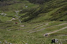
146:Zig-zags near the top of the pass
14:
454:Scheduled monuments in Scotland
383:Historic Environment Scotland.
361:Historic Environment Scotland.
339:Historic Environment Scotland.
317:Historic Environment Scotland.
295:Historic Environment Scotland.
109:built over it in 1731, between
16:Pass in the Scottish Highlands
1:
271:Historic Environment Scotland
91:General Wade's military roads
131:Prince Charles Edward Stuart
449:Mountain passes of Scotland
490:
164:Scheduled Ancient Monument
44:to Corrieyairack Pass and
464:Badenoch and Strathspey
127:Jacobite rising of 1745
459:Geography of Inverness
259:scottish.parliament.uk
147:
57:
49:
26:
145:
55:
32:
24:
420:57.05119°N 4.61136°W
70:Màm Choire Ghearraig
416: /
425:57.05119; -4.61136
254:2005-03-17 at the
148:
78:Scottish Highlands
62:Corrieyairack Pass
58:
50:
33:Garva Bridge over
27:
444:Roads in Scotland
117:to the north and
481:
431:
430:
428:
427:
426:
421:
417:
414:
413:
412:
409:
396:
395:
393:
391:
380:
374:
373:
371:
369:
358:
352:
351:
349:
347:
336:
330:
329:
327:
325:
314:
308:
307:
305:
303:
292:
286:
285:
283:
281:
267:
261:
246:
240:
239:
233:
225:
223:
221:
215:
209:. Archived from
208:
200:
88:
489:
488:
484:
483:
482:
480:
479:
478:
434:
433:
424:
422:
418:
415:
410:
407:
405:
403:
402:
400:
399:
389:
387:
382:
381:
377:
367:
365:
360:
359:
355:
345:
343:
338:
337:
333:
323:
321:
316:
315:
311:
301:
299:
294:
293:
289:
279:
277:
269:
268:
264:
256:Wayback Machine
247:
243:
226:
219:
217:
216:on 6 March 2012
213:
206:
204:"Archived copy"
202:
201:
197:
192:
157:mountain bikers
140:
99:
84:
66:Scottish Gaelic
17:
12:
11:
5:
487:
485:
477:
476:
471:
466:
461:
456:
451:
446:
436:
435:
398:
397:
375:
353:
331:
309:
287:
262:
241:
194:
193:
191:
188:
187:
186:
183:
180:
177:
174:
171:
139:
138:The pass today
136:
98:
95:
82:grid reference
39:General Wade's
15:
13:
10:
9:
6:
4:
3:
2:
486:
475:
472:
470:
467:
465:
462:
460:
457:
455:
452:
450:
447:
445:
442:
441:
439:
432:
429:
386:
379:
376:
364:
357:
354:
342:
335:
332:
320:
313:
310:
298:
291:
288:
276:
272:
266:
263:
260:
257:
253:
250:
245:
242:
237:
231:
212:
205:
199:
196:
189:
184:
181:
178:
175:
172:
169:
168:
167:
165:
160:
158:
154:
144:
137:
135:
132:
128:
124:
120:
116:
112:
111:Fort Augustus
108:
107:military road
104:
97:Military road
96:
94:
92:
87:
83:
79:
75:
71:
67:
63:
54:
47:
46:Fort Augustus
43:
42:military road
40:
36:
31:
23:
19:
401:
388:. Retrieved
378:
366:. Retrieved
356:
344:. Retrieved
334:
322:. Retrieved
312:
300:. Retrieved
290:
278:. Retrieved
265:
258:
244:
218:. Retrieved
211:the original
198:
161:
149:
103:General Wade
100:
69:
61:
59:
18:
423: /
220:15 November
123:Strath Spey
438:Categories
408:57°03′04″N
190:References
115:Great Glen
35:River Spey
411:4°36′41″W
390:29 March
368:29 March
346:29 March
324:29 March
302:29 March
280:29 March
252:Archived
230:cite web
119:Melgarve
86:NN417986
129:, when
113:in the
76:in the
153:hikers
214:(PDF)
207:(PDF)
392:2019
370:2019
348:2019
326:2019
304:2019
282:2019
236:link
222:2010
155:and
74:pass
60:The
121:in
105:'s
80:at
37:on
440::
273:.
232:}}
228:{{
68:–
394:.
372:.
350:.
328:.
306:.
284:.
238:)
224:.
64:(
Text is available under the Creative Commons Attribution-ShareAlike License. Additional terms may apply.