375:
708:
696:
724:
736:
59:
605:) has occurred in several places along Corte Madera Creek with significant damage to the surviving populations of native rainbows. In addition, there are also several private ponds stocked with warm water non-native species, such as Smallmouth Bass, Redear Sunfish and Bluegill that threaten the surviving native trout population fry and eggs. The most notable pond is on Iroquois Trail and empties into Corte Madera Creek through a single outlet which floods during El Niño, or a wet winter.
40:
1207:
66:
695:
707:
378:
Snippet of Easton's 1868 Official San Mateo County Map showing the historical town of
Searsville in between Alambique Creek (Arroyo Alembique) and Sausal Creek (and its Martin Creek tributary). Searsville was inundated by Searsville Dam and Reservoir in 1891. Modified to also show Bear Creek and San
549:
The extent by which
Searsville Reservoir serves as a source for non-native species was illustrated when Stanford biologists studied the aquatic fauna found in the plunge pool below the Searsville dam spillway. The plunge pool was drained in 2013 to allow for a safety inspection of the base of the
597:
In the spring of 1991, an adult steelhead (0.74m) was observed jumping at the base of
Searsville Dam. In May 2002, the San Francisquito Watershed Council released a barrier survey including Corte Madera Creek. A private bridge apron adjacent to Willowbrook Drive and another downstream of the
506:). They noted that the only native species observed with any regularity in the study area are Sacramento sucker and rainbow trout, and attributed the now depauperate native fish fauna to dislocation of hydrologic connectivity due to the dam, transformation of the habitat above the dam from
598:
confluence with
Damiani Creek were described as impassable barriers to upstream migrating steelhead. In 2014 a systematic study of 1,400 plus dams in California identified Searsville Dam as a high-priority candidate to improve environmental flows for native fish conservation.
735:
550:
dam. Native species found when the plunge pool was pumped dry include two steelhead trout, 26 California roach and 22 Sacramento suckers. In contrast, more than 1,500 non-native fishes were encountered during the dewatering process, including over 500 sunfish including
430:) populations live in upper Corte Madera Creek and its tributaries. In a 1996 biotic assessment of upper Searsville Lake and the lower floodplain of Corte Madera Creek, Stanford biologists wrote that the native species likely included steelhead/coastal rainbow trout (
374:
665:
and
Alambique Creek were historically tributary to Sausal Creek. This unique confluence of streams and natural wetlands was submerged and buried with sediment due to the construction of Searsville Dam and the siltation of the reservoir.
648:
enters a historic wetland pond (Lloyd's Pond) which is currently impounded by the road-fill of
Portola Road and a culvert. From there Alambique Creek flows under Portola Road into the upper Searsville Reservoir at its confluence with
723:
977:
763:
984:
1331:
1667:
1687:
1113:
701:
Shot looking southeast from Jasper Ridge's Sun Field
Station up the Corte Madera Creek watershed with Russian Ridge on the right and Montebello Ridge on the left.
58:
1141:
742:
17:
865:
Durham's Place Names of
California's San Francisco Bay Area: Includes Marin, San Francisco, San Mateo, Contra Costa, Alameda, Solano & Santa Clara counties
1221:
901:. California Department of Fish and Game, Water Projects Branch Report no. 1. Sacramento, California: California Department of Fish and Game. Archived from
1585:
1276:
1196:
1136:
325:
249:
1151:
614:
1529:
928:"Historical distribution and current status of steelhead/rainbow trout (Oncorhynchus mykiss) in streams of the San Francisco Estuary, California"
1682:
172:
1482:
1391:
840:
1236:
388:
1447:
674:
355:
1555:
1106:
1598:
1550:
873:
896:
952:
538:) occur in the lotic portions of Corte Madera Creek below the dam but not above, likely due to depredation by non-native fish and
1603:
1580:
1452:
1311:
657:
flows into Sausal Creek just upstream of the reservoir area at the Family Farm Road bridge. From there Sausal Creek joins enters
1608:
1570:
1565:
1271:
650:
621:
to pick up Coal Creek, Rengstorff Gulch, Damiani Creek, Jones Gulch, Hamms Gulch - all draining the northeastern slope of the
1672:
1630:
1625:
1590:
1560:
1266:
830:
1677:
1545:
1540:
1472:
1437:
1099:
1286:
1070:
121:
1462:
313:
1411:
1396:
1246:
812:
714:
626:
531:
235:
131:
613:
Corte Madera Creek has its origin just northeast of Borel Hill in the Coal Creek Open Space
Preserve (part of the
1575:
1356:
1646:
1513:
1326:
1281:
629:
and crosses under
Portola Road at Brookside Drive. Before reaching Searsville Reservoir it arrives in a large
475:
797:
426:. Although steelhead can no longer run above Searsville Dam to spawn, stream resident coastal rainbow trout (
1487:
309:
1508:
1457:
1371:
1291:
863:
773:
746:
678:
400:
392:
359:
483:
1043:"San Francisquito Watershed and Alluvial Fan, in Creek & Watershed Map of Palo Alto & Vicinity"
1503:
1316:
1122:
1081:
633:
or freshwater marsh formed by the nexus of several creeks, including Westbridge Creek, Sausal Creek,
622:
491:
1477:
662:
654:
634:
591:
321:
39:
1376:
1191:
1186:
447:
395:
land grants (the latter surrounding the former). Corte Madera Creek was dammed in 1892, creating
713:
Stepping stones across dry Corte Madera Creek on trail from Trail Lane to Mapache Drive Trail,
530:) which prey on virtually all historically native fishes. They noted that federally threatened
1442:
1381:
1251:
869:
836:
618:
539:
1361:
1346:
1301:
1156:
1021:
661:. Corte Madera Creek enters Searsville Reservoir further to the east. Old maps suggest that
439:
85:
1076:
1066:
1042:
1386:
1366:
1351:
1261:
1161:
816:
645:
638:
317:
953:
Biotic assessment of upper Searsville Lake and the lower floodplain of Corte Madera Creek
978:
Report on the fish relocations associated with the Searsville Dam plunge pool dewatering
902:
1416:
1306:
1226:
927:
768:
670:
658:
567:
423:
396:
351:
223:
1661:
1467:
1421:
1401:
1181:
1171:
551:
519:
455:
100:
1206:
808:
U.S. Geological Survey. National Hydrography Dataset high-resolution flowline data.
1341:
1321:
1256:
1241:
1231:
1176:
1010:"Systematic Screening of Dams for Environmental Flow Assessment and Implementation"
583:
1166:
1146:
933:. Center for Ecosystem Management and Restoration, Oakland, CA. pp. 145–146
523:
515:
499:
218:
422:) spawning stream; however, access to the creek has been blocked since 1890 by
1406:
1336:
1296:
832:
California Place Names: The Origin and Etymology of Current Geographical Names
798:
U.S. Geological Survey Geographic Names Information System: Corte Madera Creek
463:
412:
363:
110:
264:
251:
187:
174:
1026:
1009:
514:, and the fact that Searsville Reservoir harbors many non-native species of
415:
346:(Spanish for "a place where wood is cut") is a 7.3-mile-long (11.7 km)
809:
575:
559:
435:
1091:
644:
Just south of the intersection of Mountain Home Road and Portola Road,
527:
590:). Other non-native in the plunge pool included 500 bullfrogs and 150
511:
347:
1086:
507:
373:
1095:
898:
The Freshwater Fish and Fisheries of the San Francisco Bay Area
65:
601:
Illegal fishing of rainbow trout (stream resident forms of
976:
Alan Launer; Christina Feng; Annette Potvin (2013-11-15).
741:
Mouth of Corte Madera Creek (left) at its confluence with
44:
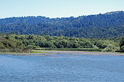
Looking south across Searsville Reservoir from the dam on
951:
Craig Fee; Alan Launer; Steve Rottenborn (1996-10-21).
1077:
Oakland Museum Map of San Francisquito Creek Watershed
729:
Corte Madera Creek just below Searsville Dam July 2011
868:. Word Dancer Press, Sanger, California. p. 44.
1639:
1522:
1496:
1430:
1214:
1129:
331:
303:
295:
290:
280:
241:
229:
217:
203:
164:
154:
146:
137:
127:
116:
106:
96:
91:
81:
28:
764:List of watercourses in the San Francisco Bay Area
617:, and follows Alpine Road northwesterly along the
312:, Gulch Creek, Rengstorff Gulch, Damiani Creek,
1008:T. E. Grantham; J. H. Viers; PB Moyle (2014).
926:Leidy, R.A.; G.S. Becker; B.N. Harvey (2005).
835:. University of California Press. p. 92.
1107:
1067:San Francisquito Watershed & Alluvial Fan
983:(Report). Stanford University. Archived from
958:(Report). Stanford University. pp. 17–18
18:Corte Madera Creek (Marin County, California)
8:
1114:
1100:
1092:
686:Photos of the Corte Madera Creek Watershed
1025:
615:Midpeninsula Regional Open Space District
921:
919:
829:Erwin G. Gudde; William Bright (2004).
785:
691:
411:Corte Madera Creek was historically an
399:, which inundated the historic town of
1668:Rivers of San Mateo County, California
793:
791:
789:
25:
1688:Tributaries of San Francisquito Creek
1483:The Forest of Nisene Marks State Park
7:
73:Location of the mouth in California
16:For the creek in Marin County, see
1087:San Francisquito Watershed Council
160:Russian Ridge Open Space Preserve.
23:River in California, United States
14:
389:Rancho Cañada del Corte de Madera
1453:Henry Cowell Redwoods State Park
1205:
734:
722:
706:
694:
64:
57:
38:
1045:. Oakland Museum of California
673:Corte Madera Creek joins with
625:. It levels out upon reaching
350:that flows north-northwest to
243: • coordinates
166: • coordinates
1:
1683:Rivers of Northern California
1473:San Bruno Mountain State Park
1438:Big Basin Redwoods State Park
749:mainstem below Searsville Dam
138:Physical characteristics
1071:Oakland Museum of California
592:Louisiana red swamp crayfish
282: • elevation
205: • elevation
1463:Portola Redwoods State Park
532:California red-legged frogs
432:Oncorhynchus mykiss irideus
420:Oncorhynchus mykiss irideus
231: • location
156: • location
1704:
236:Portola Valley, California
209:1,950 ft (590 m)
132:Portola Valley, California
15:
1203:
895:Skinner, John E. (1962).
862:Durham, David L. (1998).
819:, accessed March 15, 2011
444:Hesperoleucas symmetricus
213:
142:
52:
37:
1647:Santa Cruz Mountains AVA
1537:El Corte de Madera Creek
1514:Skyline-to-the-Sea Trail
1282:El Corte de Madera Creek
1041:Janet M. Sowers (2005).
582:species) and over 1,000
496:Orthodon microlepidontus
476:three-spined stickleback
333: • right
286:351 ft (107 m)
1586:Purisima Creek Redwoods
1488:Uvas Canyon County Park
472:Entosphenus tridentatus
468:Catostomus occidentalis
305: • left
1458:McNee Ranch State Park
1448:Castle Rock State Park
1372:San Francisquito Creek
1292:Guadalupe Valley Creek
774:San Francisquito Creek
747:San Francisquito Creek
679:San Francisquito Creek
544:Lithobates catesbeiana
480:Gasterosteus aculeatus
393:Rancho Corte de Madera
380:
360:San Francisquito Creek
265:37.40083°N 122.23833°W
188:37.32389°N 122.19000°W
1673:Palo Alto, California
1082:Beyond Searsville Dam
1027:10.1093/biosci/biu159
488:Ptychocheilus grandis
484:Sacramento pikeminnow
385:Corte de Madera Creek
377:
32:Corte De Madera Creek
1678:Santa Cruz Mountains
1523:Open Space Preserves
1504:Bay Area Ridge Trail
1317:Little Boulder Creek
1123:Santa Cruz Mountains
745:(right) forming the
659:Searsville Reservoir
623:Santa Cruz Mountains
504:Oncorhynchus kisutch
492:Sacramento blackfish
470:), Pacific lamprey (
397:Searsville Reservoir
354:and then joins with
270:37.40083; -122.23833
193:37.32389; -122.19000
1530:Bear Creek Redwoods
1509:Devil's Slide Trail
1478:Sanborn County Park
663:Dennis Martin Creek
655:Dennis Martin Creek
635:Dennis Martin Creek
572:Lepomis microlophus
564:Lepomis macrochirus
556:(Lepomis cyanellus)
460:Rhinichthys osculus
379:Francisquito Creek.
322:Dennis Martin Creek
291:Basin features
261: /
184: /
1591:Rancho San Antonio
1377:San Gregorio Creek
1192:Santa Teresa Hills
1187:San Bruno Mountain
815:2016-06-30 at the
540:American bullfrogs
381:
344:Corte Madera Creek
46:Corte Madera Creek
29:Corte Madera Creek
1655:
1654:
1616:St. Joseph's Hill
1443:Butano State Park
1392:San Vicente Creek
1382:San Lorenzo River
1252:Branciforte Creek
1215:Rivers and creeks
1020:(11): 1006–1018.
842:978-0-520-24217-3
619:San Andreas Fault
464:Sacramento sucker
452:Lavinia exilcauda
341:
340:
1695:
1362:Pilarcitos Creek
1347:Permanente Creek
1302:Harrington Creek
1209:
1157:Montara Mountain
1116:
1109:
1102:
1093:
1054:
1053:
1051:
1050:
1038:
1032:
1031:
1029:
1005:
999:
998:
996:
995:
989:
982:
973:
967:
966:
964:
963:
957:
948:
942:
941:
939:
938:
932:
923:
914:
913:
911:
910:
892:
886:
885:
883:
882:
859:
853:
852:
850:
849:
826:
820:
810:The National Map
806:
800:
795:
738:
726:
710:
698:
588:Gambusia affinis
576:bullhead catfish
440:California roach
387:ran through the
334:
306:
276:
275:
273:
272:
271:
266:
262:
259:
258:
257:
254:
206:
199:
198:
196:
195:
194:
189:
185:
182:
181:
180:
177:
167:
157:
122:San Mateo County
86:Spanish language
68:
67:
61:
42:
26:
1703:
1702:
1698:
1697:
1696:
1694:
1693:
1692:
1658:
1657:
1656:
1651:
1635:
1576:Picchetti Ranch
1518:
1492:
1426:
1387:San Pedro Creek
1367:San Bruno Creek
1352:Pescadero Creek
1332:Los Gatos Creek
1287:Guadalupe River
1262:Carbonera Creek
1210:
1201:
1162:Mount Bielawski
1125:
1120:
1063:
1058:
1057:
1048:
1046:
1040:
1039:
1035:
1007:
1006:
1002:
993:
991:
987:
980:
975:
974:
970:
961:
959:
955:
950:
949:
945:
936:
934:
930:
925:
924:
917:
908:
906:
894:
893:
889:
880:
878:
876:
861:
860:
856:
847:
845:
843:
828:
827:
823:
817:Wayback Machine
807:
803:
796:
787:
782:
760:
755:
754:
753:
750:
739:
730:
727:
718:
711:
702:
699:
688:
687:
646:Alambique Creek
639:Alambique Creek
611:
474:), and perhaps
409:
372:
337:Westridge Creek
332:
318:Alambique Creek
316:, Hamms Gulch,
304:
283:
269:
267:
263:
260:
255:
252:
250:
248:
247:
244:
232:
224:Searsville Lake
204:
192:
190:
186:
183:
178:
175:
173:
171:
170:
165:
155:
77:
76:
75:
74:
71:
70:
69:
48:
33:
30:
24:
21:
12:
11:
5:
1701:
1699:
1691:
1690:
1685:
1680:
1675:
1670:
1660:
1659:
1653:
1652:
1650:
1649:
1643:
1641:
1637:
1636:
1634:
1633:
1628:
1623:
1620:
1617:
1614:
1611:
1606:
1601:
1596:
1593:
1588:
1583:
1578:
1573:
1568:
1563:
1558:
1556:La Honda Creek
1553:
1548:
1543:
1538:
1535:
1532:
1526:
1524:
1520:
1519:
1517:
1516:
1511:
1506:
1500:
1498:
1494:
1493:
1491:
1490:
1485:
1480:
1475:
1470:
1465:
1460:
1455:
1450:
1445:
1440:
1434:
1432:
1428:
1427:
1425:
1424:
1419:
1417:Waterman Creek
1414:
1409:
1404:
1399:
1394:
1389:
1384:
1379:
1374:
1369:
1364:
1359:
1354:
1349:
1344:
1339:
1334:
1329:
1324:
1319:
1314:
1309:
1307:La Honda Creek
1304:
1299:
1294:
1289:
1284:
1279:
1274:
1269:
1264:
1259:
1254:
1249:
1244:
1239:
1234:
1229:
1227:Alamitos Creek
1224:
1218:
1216:
1212:
1211:
1204:
1202:
1200:
1199:
1194:
1189:
1184:
1179:
1174:
1169:
1164:
1159:
1154:
1149:
1144:
1139:
1137:Black Mountain
1133:
1131:
1127:
1126:
1121:
1119:
1118:
1111:
1104:
1096:
1090:
1089:
1084:
1079:
1074:
1062:
1061:External links
1059:
1056:
1055:
1033:
1000:
968:
943:
915:
887:
874:
854:
841:
821:
801:
784:
783:
781:
778:
777:
776:
771:
769:Searsville Dam
766:
759:
756:
752:
751:
740:
733:
731:
728:
721:
719:
715:Portola Valley
712:
705:
703:
700:
693:
690:
689:
685:
684:
683:
671:Searsville Dam
627:Portola Valley
610:
607:
568:redear sunfish
536:Rana draytonii
424:Searsville Dam
408:
405:
371:
368:
352:Searsville Dam
339:
338:
335:
329:
328:
307:
301:
300:
297:
293:
292:
288:
287:
284:
281:
278:
277:
245:
242:
239:
238:
233:
230:
227:
226:
221:
215:
214:
211:
210:
207:
201:
200:
168:
162:
161:
158:
152:
151:
148:
144:
143:
140:
139:
135:
134:
129:
125:
124:
118:
114:
113:
108:
104:
103:
98:
94:
93:
89:
88:
83:
79:
78:
72:
63:
62:
56:
55:
54:
53:
50:
49:
43:
35:
34:
31:
22:
13:
10:
9:
6:
4:
3:
2:
1700:
1689:
1686:
1684:
1681:
1679:
1676:
1674:
1671:
1669:
1666:
1665:
1663:
1648:
1645:
1644:
1642:
1638:
1632:
1629:
1627:
1624:
1621:
1619:Stevens Creek
1618:
1615:
1613:Skyline Ridge
1612:
1610:
1607:
1605:
1602:
1600:
1599:Russian Ridge
1597:
1594:
1592:
1589:
1587:
1584:
1582:
1579:
1577:
1574:
1572:
1569:
1567:
1564:
1562:
1559:
1557:
1554:
1552:
1551:Fremont Older
1549:
1547:
1544:
1542:
1539:
1536:
1533:
1531:
1528:
1527:
1525:
1521:
1515:
1512:
1510:
1507:
1505:
1502:
1501:
1499:
1497:Hiking trails
1495:
1489:
1486:
1484:
1481:
1479:
1476:
1474:
1471:
1469:
1468:Redwood Grove
1466:
1464:
1461:
1459:
1456:
1454:
1451:
1449:
1446:
1444:
1441:
1439:
1436:
1435:
1433:
1429:
1423:
1422:Zayante Creek
1420:
1418:
1415:
1413:
1412:Waddell Creek
1410:
1408:
1405:
1403:
1402:Tip Toe Falls
1400:
1398:
1397:Stevens Creek
1395:
1393:
1390:
1388:
1385:
1383:
1380:
1378:
1375:
1373:
1370:
1368:
1365:
1363:
1360:
1358:
1355:
1353:
1350:
1348:
1345:
1343:
1340:
1338:
1335:
1333:
1330:
1328:
1325:
1323:
1320:
1318:
1315:
1313:
1310:
1308:
1305:
1303:
1300:
1298:
1295:
1293:
1290:
1288:
1285:
1283:
1280:
1278:
1275:
1273:
1270:
1268:
1265:
1263:
1260:
1258:
1255:
1253:
1250:
1248:
1247:Boulder Creek
1245:
1243:
1240:
1238:
1235:
1233:
1230:
1228:
1225:
1223:
1220:
1219:
1217:
1213:
1208:
1198:
1195:
1193:
1190:
1188:
1185:
1183:
1182:Mount Umunhum
1180:
1178:
1175:
1173:
1172:Mount Madonna
1170:
1168:
1165:
1163:
1160:
1158:
1155:
1153:
1150:
1148:
1145:
1143:
1140:
1138:
1135:
1134:
1132:
1128:
1124:
1117:
1112:
1110:
1105:
1103:
1098:
1097:
1094:
1088:
1085:
1083:
1080:
1078:
1075:
1072:
1068:
1065:
1064:
1060:
1044:
1037:
1034:
1028:
1023:
1019:
1015:
1011:
1004:
1001:
990:on 2015-01-05
986:
979:
972:
969:
954:
947:
944:
929:
922:
920:
916:
905:on 2011-07-26
904:
900:
899:
891:
888:
877:
875:1-884995-14-4
871:
867:
866:
858:
855:
844:
838:
834:
833:
825:
822:
818:
814:
811:
805:
802:
799:
794:
792:
790:
786:
779:
775:
772:
770:
767:
765:
762:
761:
757:
748:
744:
737:
732:
725:
720:
716:
709:
704:
697:
692:
682:
680:
676:
672:
667:
664:
660:
656:
652:
647:
642:
640:
636:
632:
628:
624:
620:
616:
608:
606:
604:
603:O. m. irideus
599:
595:
593:
589:
585:
581:
577:
573:
569:
566:) and likely
565:
561:
557:
553:
552:green sunfish
547:
545:
541:
537:
533:
529:
525:
521:
517:
513:
509:
505:
501:
497:
493:
489:
485:
481:
477:
473:
469:
465:
461:
457:
456:speckled dace
453:
449:
445:
441:
437:
433:
429:
428:O. m. irideus
425:
421:
417:
414:
406:
404:
402:
398:
394:
390:
386:
383:Historically
376:
369:
367:
365:
361:
357:
353:
349:
345:
336:
330:
327:
323:
319:
315:
311:
308:
302:
298:
294:
289:
285:
279:
274:
246:
240:
237:
234:
228:
225:
222:
220:
216:
212:
208:
202:
197:
169:
163:
159:
153:
149:
145:
141:
136:
133:
130:
126:
123:
120:Southeastern
119:
115:
112:
109:
105:
102:
101:United States
99:
95:
90:
87:
84:
80:
60:
51:
47:
41:
36:
27:
19:
1604:Saratoga Gap
1581:Pulgas Ridge
1357:Peters Creek
1342:Naples Creek
1322:Llagas Creek
1312:Laguna Creek
1272:Coyote Creek
1257:Butano Creek
1242:Bogess Creek
1232:Alpine Creek
1177:Mount Thayer
1142:Crystal Peak
1047:. Retrieved
1036:
1017:
1013:
1003:
992:. Retrieved
985:the original
971:
960:. Retrieved
946:
935:. Retrieved
907:. Retrieved
903:the original
897:
890:
879:. Retrieved
864:
857:
846:. Retrieved
831:
824:
804:
668:
651:Sausal Creek
643:
630:
612:
602:
600:
596:
587:
584:mosquitofish
579:
571:
563:
555:
548:
543:
535:
503:
495:
487:
479:
471:
467:
459:
451:
443:
431:
427:
419:
410:
384:
382:
343:
342:
326:Sausal Creek
45:
1622:Teague Hill
1609:Sierra Azul
1571:Monte Bello
1566:Los Trancos
1327:Loch Lomond
1267:Clear Creek
1222:Adobe Creek
1167:Mount Chual
1147:Loma Prieta
516:centrarchid
500:coho salmon
314:Jones Gulch
296:Tributaries
268: /
256:122°14′18″W
191: /
179:122°11′24″W
1662:Categories
1631:Windy Hill
1626:Thornewood
1595:Ravenswood
1561:Long Ridge
1534:Coal Creek
1407:Uvas Creek
1337:Love Creek
1297:Hale Creek
1277:Deer Creek
1237:Bean Creek
1197:Twin Peaks
1152:Long Ridge
1049:2012-02-11
1014:BioScience
994:2015-01-05
962:2014-01-04
937:2009-12-28
909:2010-09-20
881:2010-08-30
848:2010-09-20
780:References
743:Bear Creek
675:Bear Creek
524:black bass
413:anadromous
401:Searsville
364:California
356:Bear Creek
310:Coal Creek
253:37°24′03″N
176:37°19′26″N
111:California
1546:Foothills
1541:El Sereno
717:July 2021
609:Watershed
416:steelhead
82:Etymology
813:Archived
758:See also
677:to form
580:Ameiurus
560:bluegill
518:fishes (
358:to form
92:Location
1073:website
574:), two
528:crappie
520:sunfish
498:), and
436:sculpin
407:Ecology
370:History
97:Country
872:
839:
669:Below
637:, and
631:laguna
526:, and
512:lentic
299:
150:
147:Source
117:Region
1640:Other
1431:Parks
1130:Peaks
988:(PDF)
981:(PDF)
956:(PDF)
931:(PDF)
508:lotic
448:hitch
348:creek
219:Mouth
107:State
870:ISBN
837:ISBN
391:and
128:City
1069:at
1022:doi
546:).
510:to
490:),
482:),
462:),
454:),
446:),
434:),
362:in
1664::
1018:64
1016:.
1012:.
918:^
788:^
681:.
653:.
641:.
594:.
558:,
522:,
438:,
403:.
366:.
324:,
320:,
1115:e
1108:t
1101:v
1052:.
1030:.
1024::
997:.
965:.
940:.
912:.
884:.
851:.
586:(
578:(
570:(
562:(
554:(
542:(
534:(
502:(
494:(
486:(
478:(
466:(
458:(
450:(
442:(
418:(
20:.
Text is available under the Creative Commons Attribution-ShareAlike License. Additional terms may apply.